Coral Sea: HAMISH - Tropical Cyclone

Moderator: S2k Moderators

Message
Author
User avatar
HURAKAN
Professional-Met
Professional-Met
Posts: 46086
Age: 37
Joined: Thu May 20, 2004 4:34 pm
Location: Key West, FL
Contact:

#141 Postby HURAKAN » Sat Mar 07, 2009 9:22 pm

Image

WTPS31 PGTW 080300
MSGID/GENADMIN/NAVMARFCSTCEN PEARL HARBOR HI/JTWC//
SUBJ/TROPICAL CYCLONE 18P (HAMISH) WARNING NR 006//
RMKS/
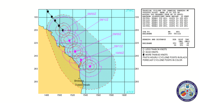
1. TROPICAL CYCLONE 18P (HAMISH) WARNING NR 06
01 ACTIVE TROPICAL CYCLONE IN SOUTHPAC
MAX SUSTAINED WINDS BASED ON ONE-MINUTE AVERAGE
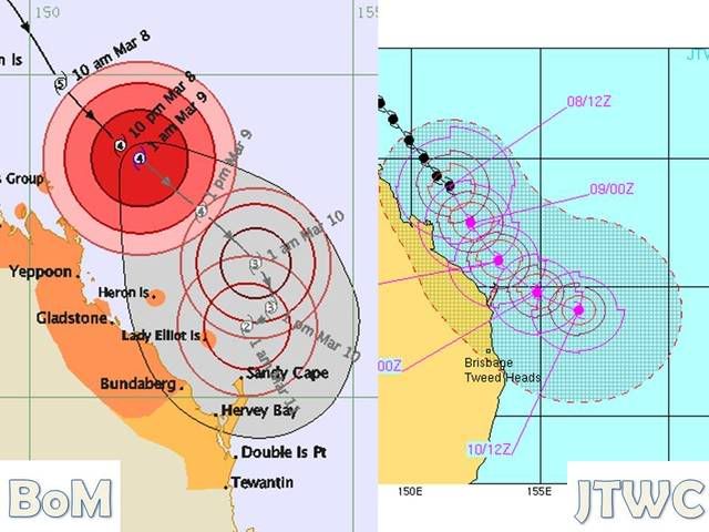
---
WARNING POSITION:
080000Z --- NEAR 20.0S 150.5E
MOVEMENT PAST SIX HOURS - 140 DEGREES AT 09 KTS
POSITION ACCURATE TO WITHIN 020 NM
POSITION BASED ON EYE FIXED BY SATELLITE
PRESENT WIND DISTRIBUTION:
MAX SUSTAINED WINDS - 130 KT, GUSTS 160 KT
WIND RADII VALID OVER OPEN WATER ONLY
RADIUS OF 064 KT WINDS - 050 NM NORTHEAST QUADRANT
050 NM SOUTHEAST QUADRANT
040 NM SOUTHWEST QUADRANT
040 NM NORTHWEST QUADRANT
RADIUS OF 050 KT WINDS - 070 NM NORTHEAST QUADRANT
065 NM SOUTHEAST QUADRANT
065 NM SOUTHWEST QUADRANT
065 NM NORTHWEST QUADRANT
RADIUS OF 034 KT WINDS - 130 NM NORTHEAST QUADRANT
110 NM SOUTHEAST QUADRANT
115 NM SOUTHWEST QUADRANT
125 NM NORTHWEST QUADRANT
REPEAT POSIT: 20.0S 150.5E
---
FORECASTS:
12 HRS, VALID AT:
081200Z --- 21.6S 151.5E
MAX SUSTAINED WINDS - 125 KT, GUSTS 150 KT
WIND RADII VALID OVER OPEN WATER ONLY
RADIUS OF 064 KT WINDS - 050 NM NORTHEAST QUADRANT
045 NM SOUTHEAST QUADRANT
040 NM SOUTHWEST QUADRANT
050 NM NORTHWEST QUADRANT
RADIUS OF 050 KT WINDS - 070 NM NORTHEAST QUADRANT
070 NM SOUTHEAST QUADRANT
070 NM SOUTHWEST QUADRANT
075 NM NORTHWEST QUADRANT
RADIUS OF 034 KT WINDS - 090 NM NORTHEAST QUADRANT
105 NM SOUTHEAST QUADRANT
115 NM SOUTHWEST QUADRANT
100 NM NORTHWEST QUADRANT
VECTOR TO 24 HR POSIT: 155 DEG/ 09 KTS
---
24 HRS, VALID AT:
090000Z --- 23.3S 152.4E
MAX SUSTAINED WINDS - 115 KT, GUSTS 140 KT
WIND RADII VALID OVER OPEN WATER ONLY
RADIUS OF 064 KT WINDS - 050 NM NORTHEAST QUADRANT
045 NM SOUTHEAST QUADRANT
040 NM SOUTHWEST QUADRANT
050 NM NORTHWEST QUADRANT
RADIUS OF 050 KT WINDS - 065 NM NORTHEAST QUADRANT
065 NM SOUTHEAST QUADRANT
065 NM SOUTHWEST QUADRANT
070 NM NORTHWEST QUADRANT
RADIUS OF 034 KT WINDS - 085 NM NORTHEAST QUADRANT
100 NM SOUTHEAST QUADRANT
110 NM SOUTHWEST QUADRANT
095 NM NORTHWEST QUADRANT
VECTOR TO 36 HR POSIT: 150 DEG/ 08 KTS
---
36 HRS, VALID AT:
091200Z --- 24.6S 153.3E
MAX SUSTAINED WINDS - 110 KT, GUSTS 135 KT
WIND RADII VALID OVER OPEN WATER ONLY
RADIUS OF 064 KT WINDS - 045 NM NORTHEAST QUADRANT
040 NM SOUTHEAST QUADRANT
035 NM SOUTHWEST QUADRANT
045 NM NORTHWEST QUADRANT
RADIUS OF 050 KT WINDS - 055 NM NORTHEAST QUADRANT
055 NM SOUTHEAST QUADRANT
060 NM SOUTHWEST QUADRANT
065 NM NORTHWEST QUADRANT
RADIUS OF 034 KT WINDS - 080 NM NORTHEAST QUADRANT
095 NM SOUTHEAST QUADRANT
100 NM SOUTHWEST QUADRANT
090 NM NORTHWEST QUADRANT
VECTOR TO 48 HR POSIT: 130 DEG/ 08 KTS
---
EXTENDED OUTLOOK:
48 HRS, VALID AT:
100000Z --- 25.6S 154.7E
MAX SUSTAINED WINDS - 100 KT, GUSTS 125 KT
WIND RADII VALID OVER OPEN WATER ONLY
RADIUS OF 064 KT WINDS - 035 NM NORTHEAST QUADRANT
035 NM SOUTHEAST QUADRANT
035 NM SOUTHWEST QUADRANT
035 NM NORTHWEST QUADRANT
RADIUS OF 050 KT WINDS - 055 NM NORTHEAST QUADRANT
055 NM SOUTHEAST QUADRANT
060 NM SOUTHWEST QUADRANT
065 NM NORTHWEST QUADRANT
RADIUS OF 034 KT WINDS - 080 NM NORTHEAST QUADRANT
095 NM SOUTHEAST QUADRANT
100 NM SOUTHWEST QUADRANT
090 NM NORTHWEST QUADRANT
---
REMARKS:
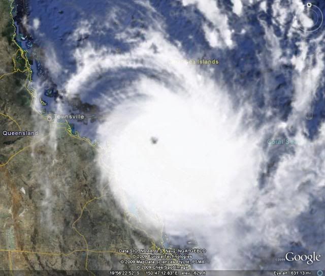
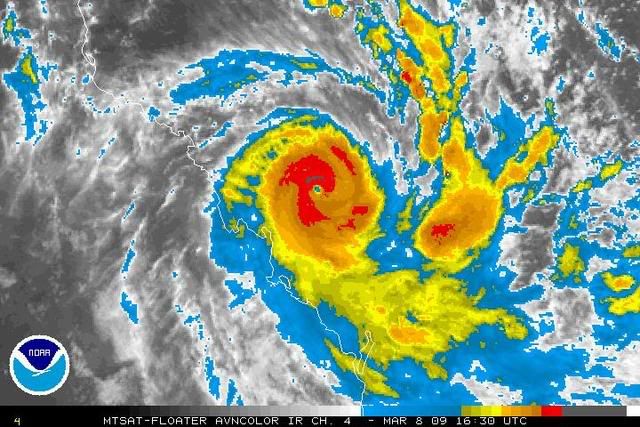
080300Z POSITION NEAR 20.4S 150.8E.
TROPICAL CYCLONE (TC) 18P (HAMISH), LOCATED APPROXIMATELY 465 NM
NORTH-NORTHWEST OF BRISBANE, AUSTRALIA, HAS TRACKED SOUTHEASTWARD
AT 09 KNOTS OVER THE PAST 06 HOURS. ANIMATED INFRARED AND MULTI-
SPECTRAL IMAGERY INDICATES THAT AN TC 18P HAS MAINTAINED ITS STRONG
INTENSITY OVER THE PAST 12 HOURS. BASED ON RADAR IMAGERY FROM
MACKAY, AUSTRALIA AND SATELLITE IMAGERY, THERE IS HIGH CONFIDENCE IN
THE POSITION OF THE SYSTEM. TC 18P HAS MAINTAINED A STEADY TRACK TO
THE SOUTHEAST AND IS EXPECTED TO CONTINUE TRACKING ALONG THE EASTERN
COAST OF AUSTRALIA. CURRENT MODEL GUIDANCE SUGGESTS TC 16S WILL NOT
MAKE LANDFALL, HOWEVER THE CLOSE PROXIMITY TO LAND WILL BEGIN TO
ADVERSELY AFFECT THE INTENSITY. INCREASING VERTICAL WIND SHEAR WILL
BEGIN TO INCREASE AROUND TAU 24 HELPING WEAKEN THE TC MORE RAPIDLY.
MAXIMUM SIGNIFICANT WAVE HEIGHT AT 080000Z IS 19 FEET. NEXT WARNINGS
AT 081500Z AND 090300Z.
0 likes   

User avatar
HURAKAN
Professional-Met
Professional-Met
Posts: 46086
Age: 37
Joined: Thu May 20, 2004 4:34 pm
Location: Key West, FL
Contact:

#142 Postby HURAKAN » Sat Mar 07, 2009 9:32 pm

Image
0 likes   

Squarethecircle
Category 5
Category 5
Posts: 2165
Joined: Fri Oct 19, 2007 4:00 pm
Location: Fairfax, VA

#143 Postby Squarethecircle » Sat Mar 07, 2009 9:34 pm

130 to 135 knots sound about right, though the eye is still emptying (convection also appears to be increasing). Again, the last report should have been higher, but I digress.
0 likes   

User avatar
Chacor
Category 5
Category 5
Posts: 10229
Joined: Mon Oct 02, 2006 10:43 pm
Location: Singapore

#144 Postby Chacor » Sat Mar 07, 2009 9:55 pm

BoM are holding at 115 kt.

AXAU21 ABRF 080047
IDQ20018
TROPICAL CYCLONE TECHNICAL BULLETIN: AUSTRALIA - EASTERN REGION
Issued by BRISBANE TROPICAL CYCLONE WARNING CENTRE
at: 0046 UTC 08/03/2009
Name: Severe Tropical Cyclone Hamish
Identifier: 17U
Data At: 0000 UTC
Latitude: 20.1S
Longitude: 150.5E
Location Accuracy: within 15 nm [28 km]
Movement Towards: south southeast [150 deg]
Speed of Movement: 10 knots [19 km/h]
Maximum 10-Minute Wind: 115 knots [215 km/h]
Maximum 3-Second Wind Gust: 160 knots [295 km/h]
Central Pressure: 925 hPa
Radius of 34-knot winds NE quadrant: 120 nm [220 km]
Radius of 34-knot winds SE quadrant: 120 nm [220 km]
Radius of 34-knot winds SW quadrant: 120 nm [220 km]
Radius of 34-knot winds NW quadrant: 120 nm [220 km]
Radius of 48-knot winds NE quadrant: 60 nm [110 km]
Radius of 48-knot winds SE quadrant: 60 nm [110 km]
Radius of 48-knot winds SW quadrant: 60 nm [110 km]
Radius of 48-knot winds NW quadrant: 60 nm [110 km]
Radius of 64-knot winds: 35 nm [65 km]
Radius of Maximum Winds: 25 nm
Dvorak Intensity Code: T6.5/6.5/D1.5/24HRS
Pressure of outermost isobar: 1006 hPa
Radius of outermost closed isobar: 150 nm [280 km]
Storm Depth: Deep
FORECAST DATA
Date/Time : Location : Loc. Accuracy: Max Wind : Central Pressure
[UTC] : degrees : nm [km]: knots[km/h]: hPa
+12: 08/1200: 21.5S 151.1E: 045 [085]: 105 [195]: 937
+24: 09/0000: 22.6S 151.8E: 075 [140]: 095 [175]: 947
+36: 09/1200: 23.5S 152.3E: 110 [200]: 090 [165]: 951
+48: 10/0000: 24.3S 152.5E: 140 [260]: 085 [155]: 955
+60: 10/1200: 25.1S 152.6E: 190 [345]: 075 [140]: 963
+72: 11/0000: 25.8S 152.7E: 235 [435]: 045 [085]: 987
REMARKS:
Final T based on DT with White surround and Off White centre based on EIR and
Reef observations. South-southeast movement expected to continue for next 48
hours.


Copyright Commonwealth of Australia
==
The next bulletin for this system will be issued by: 08/0700 UTC by Brisbane
TCWC.
0 likes   

CrazyC83
Professional-Met
Professional-Met
Posts: 33393
Joined: Tue Mar 07, 2006 11:57 pm
Location: Deep South, for the first time!

#145 Postby CrazyC83 » Sat Mar 07, 2009 10:54 pm

Here is what I would have for the BT intensities personally (based on my own guesses, except for a couple pressures):

6/1200Z - 80 kt/967mb
6/1800Z - 90 kt/956mb (pressure based on reef obs around 1900Z)
7/0000Z - 105 kt/947mb (pressure based on reef obs)
7/0600Z - 125 kt/931mb
7/1200Z - 135 kt/923mb
7/1800Z - 145 kt/914mb
8/0000Z - 140 kt/918mb
NOW - 130 kt/924mb
0 likes   

Squarethecircle
Category 5
Category 5
Posts: 2165
Joined: Fri Oct 19, 2007 4:00 pm
Location: Fairfax, VA

#146 Postby Squarethecircle » Sun Mar 08, 2009 12:47 am

Looks really brilliant right now. Very round eye on vis (it looks like there's a thunderstorm obscuring part of the eye in some images, but a lower EV image reveals it's just a clipped highlight), and a fairly warm and very round eye on the IR. However, microwave from about 330Z reveals a fairly clear ERC underway.
0 likes   

User avatar
Crostorm
Category 5
Category 5
Posts: 2060
Age: 49
Joined: Mon Dec 25, 2006 3:51 pm
Location: Croatia-Europe
Contact:

Re: Coral Sea: HAMISH - Severe Tropical Cyclone

#147 Postby Crostorm » Sun Mar 08, 2009 3:39 am

Minister for Emergency Services
The Honourable Neil Roberts
08/03/2009
Resources in place as Cyclone Hamish heads south

Additional Emergency Management Queensland personnel and thousands of sandbags and tarps are now in place in major centres between Mackay and Hervey Bay as Tropical Cyclone Hamish continues to move south parallel to the Queensland coast.

Tropical Cyclone Hamish remains a category 4 cyclone, and as at 2pm today was estimated to be 170 kilometres east-northeast of Mackay and 305 kilometres north of Yeppoon. The system is moving south-southeast at 17 kilometres per hour.

Emergency Services Minister Neil Roberts said staff from across all of his department's divisions had been deployed along the central coast over the weekend.

"The key to an efficient and effective response in a natural disaster is to be well-prepared," Mr Roberts said.

"Our deployment of additional resources will ensure we respond to the communities' needs as quickly as possible.

"More than 40 additional Urban Search and Rescue (USAR) personnel from the Queensland Fire and Rescue Service (QFRS) have been deployed to Rockhampton, with another eight swift water rescue personnel moving from Airlie Beach and Proserpine to Rockhampton today.

"Twenty QFRS Incident Management Team (IMT) members are also on standby, with another 20 to be sourced from the Brisbane area to deploy if necessary.

"Also based in Rockhampton are two Queensland Ambulance Service Special Operations Response Teams (SORT)."

Mr Roberts said a 30-strong strike team of State Emergency Service volunteers from Townsville were also being deployed south to bolster volunteer numbers.

Fourteen Emergency Management Queensland (EMQ) staff from the South Eastern and South Western Regions were yesterday deployed to Mackay, Rockhampton, Maryborough and Hervey Bay.

Additional supplies of equipment have also been transported to Central Queensland, including 1,900 tarps and 6,000 sandbags. In addition, 500 metres of flood barrier equipment and two floodbo ats will arrive in Rockhampton this afternoon.

"These additional resources will be deployed to the communities that most need them as the cyclone threat continues to move south," Mr Roberts said.

Over the next 48 hours, damaging wind gusts and flash flooding due to large seas, high tides and heavy rain is possible in coastal areas between Mackay and Tewantin.

Evacuations are now underway on Heron and Lady Elliott islands, with only a skeleton staff to remain on these islands. Up to 1,000 campers, and another 2,000 residents and resort guests, will be evacuated from Fraser Island by barge to Rainbow Beach by this afternoon.

Emergency services will be working closely with the Bureau of Meteorology (BOM) and local authorities in the towns of 1770 and Yeppoon, as well as across the Fraser Coast, over the next 24 hours to monitor weather conditions.

EMQ Executive Director Frank Pagano said it was important that residents were adequately pre pared for severe weather conditions over the next few days.

"One of the most valuable items you can have as a cyclone approaches is a battery-operated radio. This will keep you up-to-date with weather conditions and what action you may need to take," Mr Pagano said.

He added that people should put together an emergency kit. This should contain a first aid kit, torch, spare batteries, matches, waterproof bags, necessary medication, spare clothing, valuables, canned food and water supplies. A list of emergency numbers and important documentation should also be placed in your emergency kit.

Mr Pagano said that Tropical Cyclone Hamish had the potential to produce substantial rain and storm surges over the next few days and urged people to remain alert to rapidly changing weather conditions.

"A storm surge is a rise above the normal water level along a shore resulting from strong onshore winds and reduced atmospheric pressure. And in some cases, th is could be a number of metres depending on cyclone conditions," Mr Pagano said.

"The Department of Emergency Services will be working closely with the Bureau of Meteorology to constantly assess the risk of storm surges along the coast as Tropical Cyclone Hamish moves south. If necessary, people living in at-risk areas will be evacuated.

"People are urged to limit their travel into the cyclone watch and warning areas over the next few days, and also be aware of the dangers of flash flooding in drains, creeks and causeways after heavy rain and stay away from these areas," he said.

For assistance from the SES contact 132 500. For life-threatening emergencies dial triple zero (000).

For more information on how to prepare for a cyclone the public are urged to visit http://www.disaster.qld.gov.au and for the latest weather reports visit the Bureau of Meteorology website at http://www.bom.gov.au

Media contact: Minister's office - Scott Chandler on 0499 096 204; Department of Emergency Services Media on 3247 8186.
0 likes   

User avatar
Crostorm
Category 5
Category 5
Posts: 2060
Age: 49
Joined: Mon Dec 25, 2006 3:51 pm
Location: Croatia-Europe
Contact:

#148 Postby Crostorm » Sun Mar 08, 2009 3:50 am

Image
0 likes   

User avatar
Crostorm
Category 5
Category 5
Posts: 2060
Age: 49
Joined: Mon Dec 25, 2006 3:51 pm
Location: Croatia-Europe
Contact:

#149 Postby Crostorm » Sun Mar 08, 2009 3:58 am

IDQP0005
Australian Government Bureau of Meteorology
Queensland
Tropical Cyclone Warning Centre

Media: The Standard Emergency Warning Signal should NOT be used with this
warning.

TOP PRIORITY FOR
TROPICAL CYCLONE ADVICE NUMBER 23
Issued by the Bureau of Meteorology, Brisbane
Issued at 4:56pm on Sunday the 8th of March 2009

A Cyclone WARNING remains current for coastal and island communities from Saint
Lawrence to Bundaberg [including the Percy group of islands]. A Cyclone WATCH
remains current for coastal and island communities from Bundaberg to Tewantin.

The Cyclone WARNING from Mackay to Saint Lawrence has been cancelled.

Severe Tropical Cyclone Hamish, a CATEGORY 4 CYCLONE, is located off the north
Queensland coast and at 4:00 pm EST was estimated to be 215 kilometres northeast
of St Lawrence and 260 kilometres north of Yeppoon, moving southeast at 13
kilometres per hour.

Severe Tropical Cyclone Hamish poses a significant threat to coastal and island
communities between Saint Lawrence and Bundaberg [including the Percy group of
islands]. The cyclone is expected to maintain a southeast track parallel to the
coast during the next 24 to 48 hours.

Damaging wind gusts are expected to affect coastal and island communities
between Saint Lawrence and Bundaberg during the next 24 hours.

Destructive winds are expected to affect island communities between Saint
Lawrence and Bundaberg [including the Percy group of islands] during the next 24
hours.

Damaging winds are not expected to develop about coastal and island communities
between Bundaberg and Tewantin during the next 24 hours, however they may
develop within 48 hours.

As the cyclone moves to the southeast, sea levels are expected to be elevated
above the normal tide along the coastline south of the cyclone. Large waves may
produce minor flooding along the foreshore. People living in areas likely to be
affected by this flooding should take measures to protect their property as much
as possible and be prepared to help their neighbours.

Heavy rainbands associated with Severe Tropical Cyclone Hamish are likely to
cause some flooding in smaller coastal rivers and streams between Mackay and
Yeppoon tonight. Heavy rainfalls are likely to affect the coastal streams
between Yeppoon and Fraser Island during Monday and Tuesday. A separate Flood
Warning has been issued for these areas.


Details of Severe Tropical Cyclone Hamish at 4:00 pm EST:
.Centre located near...... 20.8 degrees South 150.8 degrees East
.Location accuracy........ within 28 kilometres
.Recent movement.......... towards the southeast at 13 kilometres per hour
.Wind gusts near centre... 240 kilometres per hour
.Severity category........ 4
.Central pressure......... 950 hectoPascals

People between Saint Lawrence and Bundaberg [including the Percy group of
islands] should immediately commence or continue preparations, especially
securing boats and property.

People between Bundaberg and Tewantin should consider what action they will need
to take if the cyclone threat increases. If you are unsure about the actions to
be taken, information is available from your local government or local State
Emergency Service.


The next advice will be issued by 8:00 pm EST Sunday 08 March.


This warning is also available through TV and Radio Broadcasts; the Bureau's
website at http://www.bom.gov.au or call 1300 659 212. The Bureau and the State
Emergency Service would appreciate this warning being broadcast regularly.
0 likes   

User avatar
Crostorm
Category 5
Category 5
Posts: 2060
Age: 49
Joined: Mon Dec 25, 2006 3:51 pm
Location: Croatia-Europe
Contact:

#150 Postby Crostorm » Sun Mar 08, 2009 4:04 am

Image
0 likes   

User avatar
Crostorm
Category 5
Category 5
Posts: 2060
Age: 49
Joined: Mon Dec 25, 2006 3:51 pm
Location: Croatia-Europe
Contact:

#151 Postby Crostorm » Sun Mar 08, 2009 5:56 am

WWPS20 KNES 080926

A. 18P (HAMISH)

B. 08/0830Z

C. 20.8S

D. 151.2E

E. ONE/MTSAT

F. T6.0/6.5/W0.5/06HRS

G. IR/EIR

H. REMARKS...STORM WEAKENING SLIGHTLY WITH B SURROUND YIELDING AN E
NUMBER OF 5.5. OW/W EYE ADJUSTMENT OF PLUS 0.5 YIELDING A FINAL DT OF
6.0. MET AND PT AGREE WITH DT. FT BASED ON MET.

I. ADDL POSITIONS

NIL


...EVANS
0 likes   

User avatar
Chacor
Category 5
Category 5
Posts: 10229
Joined: Mon Oct 02, 2006 10:43 pm
Location: Singapore

#152 Postby Chacor » Sun Mar 08, 2009 8:40 am

Strengthened slightly (90 kt 950 hPa at 06z, now 95 kt 945 hPa).

AXAU21 ABRF 081246
IDQ20018
TROPICAL CYCLONE TECHNICAL BULLETIN: AUSTRALIA - EASTERN REGION
Issued by BRISBANE TROPICAL CYCLONE WARNING CENTRE
at: 1246 UTC 08/03/2009
Name: Severe Tropical Cyclone Hamish
Identifier: 17U
Data At: 1200 UTC
Latitude: 21.1S
Longitude: 151.4E
Location Accuracy: within 15 nm [28 km]
Movement Towards: southeast [138 deg]
Speed of Movement: 6 knots [12 km/h]
Maximum 10-Minute Wind: 95 knots [175 km/h]
Maximum 3-Second Wind Gust: 135 knots [250 km/h]
Central Pressure: 945 hPa
Radius of 34-knot winds NE quadrant: 120 nm [220 km]
Radius of 34-knot winds SE quadrant: 120 nm [220 km]
Radius of 34-knot winds SW quadrant: 120 nm [220 km]
Radius of 34-knot winds NW quadrant: 120 nm [220 km]
Radius of 48-knot winds NE quadrant: 70 nm [130 km]
Radius of 48-knot winds SE quadrant: 70 nm [130 km]
Radius of 48-knot winds SW quadrant: 70 nm [130 km]
Radius of 48-knot winds NW quadrant: 70 nm [130 km]
Radius of 64-knot winds: 45 nm [85 km]
Radius of Maximum Winds: 35 nm [65 km]
Dvorak Intensity Code: T6.0/6.0/W0.5/24HRS
Pressure of outermost isobar: 1004 hPa
Radius of outermost closed isobar: 120 nm [220 km]
Storm Depth: Deep
FORECAST DATA
Date/Time : Location : Loc. Accuracy: Max Wind : Central Pressure
[UTC] : degrees : nm [km]: knots[km/h]: hPa
+12: 09/0000: 21.9S 152.3E: 045 [085]: 095 [175]: 945
+24: 09/1200: 22.7S 153.3E: 075 [140]: 085 [155]: 952
+36: 10/0000: 23.5S 153.7E: 110 [200]: 075 [140]: 960
+48: 10/1200: 23.9S 153.4E: 140 [260]: 065 [120]: 970
+60: 11/0000: 24.1S 152.9E: 190 [350]: 055 [100]: 980
+72: 11/1200: 24.5S 152.4E: 230 [425]: 050 [095]: 985
REMARKS:
Eye pattern with B surround, OW eye and W surrounding ring. DT is 6.0. MET
supports. Recent radar imagery is suggestive of new outer eyewall formation.
System is expected to continue to track ESE for 24 to 36 hours before
encountering moderate to strong wind shear. After this time the low level
circulation is expected to be steered westward by surface ridging.

Copyright Commonwealth of Australia
==
The next bulletin for this system will be issued by: 08/1900 UTC by Brisbane
TCWC.
0 likes   

User avatar
HURAKAN
Professional-Met
Professional-Met
Posts: 46086
Age: 37
Joined: Thu May 20, 2004 4:34 pm
Location: Key West, FL
Contact:

#153 Postby HURAKAN » Sun Mar 08, 2009 10:55 am

TROPICAL CYCLONE ADVICE NUMBER 26
Issued by the Bureau of Meteorology, Brisbane
Issued at 1:41am on Monday the 9th of March 2009

A Cyclone WARNING remains current for coastal and island communities from Saint
Lawrence to Bundaberg. A Cyclone WATCH remains current for coastal and island
communities from Bundaberg to Tewantin.

Severe Tropical Cyclone Hamish, a CATEGORY 4 CYCLONE, is located off the central
Queensland coast and at 1:00 am EST was estimated to be 260 kilometres east of
Mackay and 225 kilometres north northeast of Yeppoon, moving southeast at 12
kilometres per hour.

Severe Tropical Cyclone Hamish poses a threat to exposed coastal and island
communities between Saint Lawrence and Bundaberg [including the Percy group of
islands and Heron Island]. The cyclone is expected to maintain a southeast track
parallel to the coast during the next 24 hours.

Damaging winds are currently occurring in exposed coastal areas and islands
between Shoalwater Bay and Gladstone and are expected to extend south over other
exposed coastal and island communities to Bundaberg during Monday.

Damaging winds are not expected to develop about coastal and island communities
between Bundaberg and Tewantin during the next 24 hours, however they may
develop within 48 hours.

As the cyclone moves to the southeast, sea levels are expected to be elevated
above the normal tide along the coastline. Large waves may produce minor
flooding along the foreshore. People living in areas likely to be affected by
this flooding should take measures to protect their property as much as possible
and be prepared to help their neighbours.

Areas of heavy rainfall are likely to develop between Yeppoon and Tewantin on
Monday.


Details of Severe Tropical Cyclone Hamish at 1:00 am EST:
.Centre located near...... 21.3 degrees South 151.7 degrees East
.Location accuracy........ within 28 kilometres
.Recent movement.......... towards the southeast at 12 kilometres per hour
.Wind gusts near centre... 250 kilometres per hour
.Severity category........ 4
.Central pressure......... 945 hectoPascals

People between Saint Lawrence and Bundaberg should immediately commence or
continue preparations, especially securing boats and property.

People between Bundaberg and Tewantin should consider what action they will need
to take if the cyclone threat increases. If you are unsure about the actions to
be taken, information is available from your local government or local State
Emergency Service.

The next advice will be issued by 5:00 am EST Monday 09 March.


This warning is also available through TV and Radio Broadcasts; the Bureau's
website at http://www.bom.gov.au or call 1300 659 212. The Bureau and the State
Emergency Service would appreciate this warning being broadcast regularly.
0 likes   

User avatar
HURAKAN
Professional-Met
Professional-Met
Posts: 46086
Age: 37
Joined: Thu May 20, 2004 4:34 pm
Location: Key West, FL
Contact:

#154 Postby HURAKAN » Sun Mar 08, 2009 11:05 am

Image

Someone will be wrong.
0 likes   

User avatar
HURAKAN
Professional-Met
Professional-Met
Posts: 46086
Age: 37
Joined: Thu May 20, 2004 4:34 pm
Location: Key West, FL
Contact:

#155 Postby HURAKAN » Sun Mar 08, 2009 12:20 pm

Image
0 likes   

User avatar
HURAKAN
Professional-Met
Professional-Met
Posts: 46086
Age: 37
Joined: Thu May 20, 2004 4:34 pm
Location: Key West, FL
Contact:

#156 Postby HURAKAN » Sun Mar 08, 2009 2:01 pm

Australian Government Bureau of Meteorology
Queensland
Tropical Cyclone Warning Centre

Media: The Standard Emergency Warning Signal should NOT be used with this
warning.

TOP PRIORITY
TROPICAL CYCLONE ADVICE NUMBER 27
Issued by the Bureau of Meteorology, Brisbane
Issued at 4:59am on Monday the 9th of March 2009

A Cyclone WARNING is current for coastal and island communities from Yeppoon to
Hervey Bay. A Cyclone WATCH is current for coastal and island communities from
Hervey Bay to Tewantin.

The cyclone warning between Saint Lawrence and Yeppoon has been CANCELLED.

Severe Tropical Cyclone Hamish, a CATEGORY 4 CYCLONE, is located off the central
Queensland coast and at 4:00 am EST was estimated to be 230 kilometres north
northeast of Yeppoon and 395 kilometres north of Bundaberg, moving southeast at
10 kilometres per hour.

Severe Tropical Cyclone Hamish poses a threat to exposed coastal and island
communities between Yeppoon and Hervey Bay [including Heron and Lady Elliot
Islands]. The cyclone is expected to maintain a southeast track parallel to the
coast during the next 24 hours and slowly weaken.

Damaging winds are expected to affect exposed islands between Yeppoon and Hervey
Bay, and may affect coastal areas in this region if the cyclone takes a slightly
more southerly track.

Damaging winds are not expected to develop about coastal and island communities
between Hervey Bay and Tewantin during the next 24 hours, however they may
develop within 48 hours.

As the cyclone moves to the southeast, sea levels are expected to be elevated
above the normal tide along the coastline and large waves may produce minor
flooding along the foreshore, particularly between Yeppoon and Gladstone on the
high tide this morning. People living in areas likely to be affected by this
flooding should take measures to protect their property as much as possible and
be prepared to help their neighbours.


Details of Severe Tropical Cyclone Hamish at 4:00 am EST:
.Centre located near...... 21.4 degrees South 151.9 degrees East
.Location accuracy........ within 37 kilometres
.Recent movement.......... towards the southeast at 10 kilometres per hour
.Wind gusts near centre... 250 kilometres per hour
.Severity category........ 4
.Central pressure......... 945 hectoPascals

People between Yeppoon and Hervey Bay should immediately commence or continue
preparations, especially securing boats and property.

People between Hervey Bay and Tewantin should consider what action they will
need to take if the cyclone threat increases. If you are unsure about the
actions to be taken, information is available from your local government or
local State Emergency Service.

The next advice will be issued by 8:00 am EST Monday 09 March.


This warning is also available through TV and Radio Broadcasts; the Bureau's
website at http://www.bom.gov.au or call 1300 659 212. The Bureau and the State
Emergency Service would appreciate this warning being broadcast regularly.
0 likes   

User avatar
KWT
Category 5
Category 5
Posts: 31390
Joined: Tue Aug 17, 2004 11:02 am
Location: UK!!!

#157 Postby KWT » Sun Mar 08, 2009 2:14 pm

Looks very good still right now, decent central core it seems as you'd expect by a still powerful cyclone.
0 likes   

User avatar
HURAKAN
Professional-Met
Professional-Met
Posts: 46086
Age: 37
Joined: Thu May 20, 2004 4:34 pm
Location: Key West, FL
Contact:

#158 Postby HURAKAN » Sun Mar 08, 2009 2:46 pm

Image
0 likes   

User avatar
HURAKAN
Professional-Met
Professional-Met
Posts: 46086
Age: 37
Joined: Thu May 20, 2004 4:34 pm
Location: Key West, FL
Contact:

#159 Postby HURAKAN » Sun Mar 08, 2009 3:20 pm

Image

NRL: 115 knots
0 likes   

User avatar
HURAKAN
Professional-Met
Professional-Met
Posts: 46086
Age: 37
Joined: Thu May 20, 2004 4:34 pm
Location: Key West, FL
Contact:

#160 Postby HURAKAN » Sun Mar 08, 2009 5:37 pm

TROPICAL CYCLONE ADVICE NUMBER 28
Issued by the Bureau of Meteorology, Brisbane
Issued at 7:38am on Monday the 9th of March 2009

A Cyclone WARNING remains current for coastal and island communities from
Yeppoon to Hervey Bay. A Cyclone WATCH remains current for coastal and island
communities from Hervey Bay to Tewantin.

Severe Tropical Cyclone Hamish, a CATEGORY 4 CYCLONE, is located off the central
Queensland coast and at 7:00 am EST was estimated to be 215 kilometres northeast
of Yeppoon and 345 kilometres north of Bundaberg, moving southeast at 12
kilometres per hour.

Severe Tropical Cyclone Hamish poses a threat to exposed coastal and island
communities between Yeppoon and Hervey Bay [including Heron and Lady Elliot
Islands]. The cyclone is expected to maintain a southeast track parallel to the
coast during the next 24 hours and slowly weaken.

Damaging winds are expected to affect exposed islands between Yeppoon and Hervey
Bay, and may affect coastal areas in this region if the cyclone takes a more
southerly track.

Damaging winds are not expected to develop about coastal and island communities
between Hervey Bay and Tewantin during the next 24 hours, however they may
develop within 48 hours.

As the cyclone moves to the southeast, sea levels are expected to be elevated
above the normal tide along the coastline and large waves may produce minor
flooding along the foreshore, particularly between Yeppoon and Gladstone on the
high tide this morning. People living in areas likely to be affected by this
flooding should take measures to protect their property as much as possible and
be prepared to help their neighbours.

A separate SEVERE WEATHER WARNING has been issued for large southeasterly swells
and inundation above the normal high tide between Proserpine and Yeppoon.


Details of Severe Tropical Cyclone Hamish at 7:00 am EST:
.Centre located near...... 21.8 degrees South 152.2 degrees East
.Location accuracy........ within 28 kilometres
.Recent movement.......... towards the southeast at 12 kilometres per hour
.Wind gusts near centre... 250 kilometres per hour
.Severity category........ 4
.Central pressure......... 945 hectoPascals

People between Yeppoon and Hervey Bay should immediately commence or continue
preparations, especially securing boats and property.

People between Hervey Bay and Tewantin should consider what action they will
need to take if the cyclone threat increases. If you are unsure about the
actions to be taken, information is available from your local government or
local State Emergency Service.

The next advice will be issued by 11:00 am EST Monday 09 March.

This warning is also available through TV and Radio Broadcasts; the Bureau's
website at http://www.bom.gov.au or call 1300 659 212. The Bureau and the State
Emergency Service would appreciate this warning being broadcast regularly.
0 likes   


Return to “2009”

Who is online

Users browsing this forum: No registered users and 45 guests