Coral Sea: JASPER - Tropical Cyclone

Moderator: S2k Moderators

Message
Author
User avatar
HURAKAN
Professional-Met
Professional-Met
Posts: 46086
Age: 37
Joined: Thu May 20, 2004 4:34 pm
Location: Key West, FL
Contact:

Coral Sea: JASPER - Tropical Cyclone

#1 Postby HURAKAN » Wed Mar 18, 2009 8:24 pm

Image

Australian Government Bureau of Meteorology
Queensland
Tropical Cyclone Warning Centre

Media: This message is issued daily for the information of interested parties.
Media are NOT required to broadcast this message.

TROPICAL CYCLONE OUTLOOK
for the Coral Sea West of Longitude 160 East
Issued at 2:37pm on Wednesday the 18th of March 2009

The monsoon trough extends across far northern Cape York Peninsula and the
northern Coral Sea. A small low is embedded in the trough just south of Port
Moresby, and is not expected to develop significantly. Another broader low lies
over the northeast Coral Sea near 13S 157E. Environmental conditions are likely
to become more favourable for the development of this low late this week. Over
the weekend, an upper trough moving into the Coral Sea is likely to capture the
system and move it to the southeast, well off the Queensland coast.

The probability of this system becoming a tropical cyclone over the next three
days is:

Thursday: Low
Friday: Moderate
Saturday: High

Tropical Cyclone outlooks issued by Brisbane can be accessed through the
Bureau's Home Page http://www.bom.gov.au.

Please note that the Darwin Regional Forecasting Centre issues Tropical Cyclone
Outlooks that cover the Gulf of Carpentaria. Refer to the Northern Region and
Gulf 3 day outlook at http://www.bom.gov.au/weather/cyclone/tc-outlooks.shtml.
0 likes   

User avatar
KWT
Category 5
Category 5
Posts: 31390
Joined: Tue Aug 17, 2004 11:02 am
Location: UK!!!

#2 Postby KWT » Wed Mar 18, 2009 8:34 pm

Yet another system in this location, seems to be a bit of a hotbed for development over the last few weeks. Certainly has got some deep convection with it and they seem quite keen on it becoming a tropical cyclone at some point.
0 likes   

User avatar
HURAKAN
Professional-Met
Professional-Met
Posts: 46086
Age: 37
Joined: Thu May 20, 2004 4:34 pm
Location: Key West, FL
Contact:

#3 Postby HURAKAN » Thu Mar 19, 2009 4:30 am

TROPICAL CYCLONE TECHNICAL BULLETIN: AUSTRALIA - EASTERN REGION
Issued by BRISBANE TROPICAL CYCLONE WARNING CENTRE
at: 0928 UTC 19/03/2009
Name: Tropical Low
Identifier: 19U
Data At: 0600 UTC
Latitude: 16.9S
Longitude: 155.0E
Location Accuracy: within 60 nm [110 km]
Movement Towards: south southwest [200 deg]
Speed of Movement: 4 knots [7 km/h]
Maximum 10-Minute Wind: 25 knots [45 km/h]
Maximum 3-Second Wind Gust: 35 knots [65 km/h]
Central Pressure: 999 hPa
Radius of 34-knot winds NE quadrant:
Radius of 34-knot winds SE quadrant:
Radius of 34-knot winds SW quadrant:
Radius of 34-knot winds NW quadrant:
Radius of 48-knot winds NE quadrant:
Radius of 48-knot winds SE quadrant:
Radius of 48-knot winds SW quadrant:
Radius of 48-knot winds NW quadrant:
Radius of 64-knot winds:
Radius of Maximum Winds: n/a
Dvorak Intensity Code: T2.0/2.0/D1.0/12HRS
Pressure of outermost isobar: 1000 hPa
Radius of outermost closed isobar: 90 nm [165 km]
Storm Depth: Shallow
FORECAST DATA
Date/Time : Location : Loc. Accuracy: Max Wind : Central Pressure
[UTC] : degrees : nm [km]: knots[km/h]: hPa
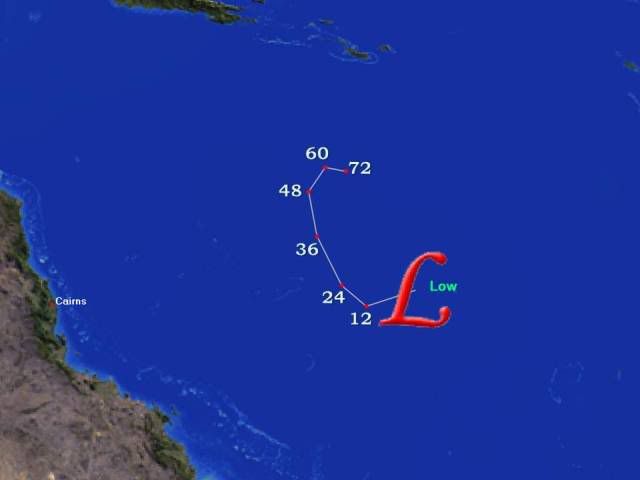
+12: 19/1800: 17.7S 154.2E: 090 [165]: 030 [055]: 995
+24: 20/0600: 17.5S 153.1E: 120 [220]: 030 [055]: 995
+36: 20/1800: 16.8S 152.6E: 150 [280]: 035 [065]: 992
+48: 21/0600: 15.4S 152.2E: 185 [345]: 050 [095]: 984
+60: 21/1800: 14.6S 152.5E: 230 [430]: 060 [110]: 975
+72: 22/0600: 14.6S 154.0E: 290 [535]: 065 [120]: 973
REMARKS:
Irregular vis CDO pattern. DT is 2.0. MET is 1.5. PAT is 2.0. Final T is 2.0.
System expected to be slow moving in a weak steering environment during the next
24 to 48 hours. Slow to average deepening forecast under weak shear.


Copyright Commonwealth of Australia
==
The next bulletin for this system will be issued by: 19/1300 UTC by Brisbane
TCWC.
0 likes   

User avatar
HURAKAN
Professional-Met
Professional-Met
Posts: 46086
Age: 37
Joined: Thu May 20, 2004 4:34 pm
Location: Key West, FL
Contact:

Re: Coral Sea: Invest 98P

#4 Postby HURAKAN » Thu Mar 19, 2009 5:16 am

AN AREA OF CONVECTION HAS PERSISTED NEAR 16.5S 154.3E,
APPROXIMATELY 490 NM EAST OF CAIRNS, AUSTRALIA. RECENT ANIMATED
MULTISPECTRAL SATELLITE IMAGERY SHOWS CONVECTIVE BANDING DEVELOP-
ING ALONG THE EASTERN AND SOUTHWESTERN PERIPHERIES OF A BROAD
LOW LEVEL CIRCULATION CENTER EVIDENT IN AN 182008Z QUIKSCAT PASS.
A FLARE OF DEEP CONVECTION HAS RECENTLY DEVELOPED NEAR THE CENTER
OF THIS LOW LEVEL CIRCULATION. THE DISTURBANCE LIES IN AN AREA OF
LOW VERTICAL WIND SHEAR BENEATH THE AXIS OF AN UPPER LEVEL RIDGE.
UPPER LEVEL ANALYIS FURTHER INDICATES VERY STRONG POLEWARD OUTFLOW
AHEAD OF AN APPROACHING MIDLATITUDE TROUGH TO THE SOUTHWEST.
MAXIMUM SUSTAINED SURFACE WINDS ARE ESTIMATED AT 25 TO 30 KNOTS.
MINIMUM SEA LEVEL PRESSURE IS ESTIMATED TO BE NEAR 1001 MB. BASED
ON AN IMPROVING LOW LEVEL SIGNATURE AND VERY FAVORABLE UPPER LEVEL
SUPPORT, THE POTENTIAL FOR THE DEVELOPMENT OF A SIGNIFICANT
TROPICAL CYCLONE WITHIN THE NEXT 24 HOURS IS FAIR.

Image

Image
0 likes   

User avatar
HURAKAN
Professional-Met
Professional-Met
Posts: 46086
Age: 37
Joined: Thu May 20, 2004 4:34 pm
Location: Key West, FL
Contact:

#5 Postby HURAKAN » Thu Mar 19, 2009 5:17 am

19/0830 UTC 16.3S 154.4E T1.5/1.5 98P -- Southwest Pacific
0 likes   

User avatar
HURAKAN
Professional-Met
Professional-Met
Posts: 46086
Age: 37
Joined: Thu May 20, 2004 4:34 pm
Location: Key West, FL
Contact:

#6 Postby HURAKAN » Thu Mar 19, 2009 7:48 am

TROPICAL CYCLONE TECHNICAL BULLETIN: AUSTRALIA - EASTERN REGION
Issued by BRISBANE TROPICAL CYCLONE WARNING CENTRE
at: 1246 UTC 19/03/2009
Name: Tropical Low
Identifier: 19U
Data At: 1200 UTC
Latitude: 17.4S
Longitude: 154.9E
Location Accuracy: within 60 nm [110 km]
Movement Towards: south southwest [200 deg]
Speed of Movement: 4 knots [7 km/h]
Maximum 10-Minute Wind: 25 knots [45 km/h]
Maximum 3-Second Wind Gust: 35 knots [65 km/h]
Central Pressure: 999 hPa
Radius of 34-knot winds NE quadrant:
Radius of 34-knot winds SE quadrant:
Radius of 34-knot winds SW quadrant:
Radius of 34-knot winds NW quadrant:
Radius of 48-knot winds NE quadrant:
Radius of 48-knot winds SE quadrant:
Radius of 48-knot winds SW quadrant:
Radius of 48-knot winds NW quadrant:
Radius of 64-knot winds:
Radius of Maximum Winds: n/a
Dvorak Intensity Code: T2.0/2.0/S0.0/6HRS
Pressure of outermost isobar: 1002 hPa
Radius of outermost closed isobar: 105 nm [195 km]
Storm Depth: Shallow
FORECAST DATA
Date/Time : Location : Loc. Accuracy: Max Wind : Central Pressure
[UTC] : degrees : nm [km]: knots[km/h]: hPa
+12: 20/0000: 17.8S 153.7E: 090 [165]: 030 [055]: 995
+24: 20/1200: 17.3S 153.1E: 120 [220]: 030 [055]: 994
+36: 21/0000: 16.1S 152.5E: 150 [280]: 040 [075]: 990
+48: 21/1200: 15.0S 152.3E: 185 [345]: 055 [100]: 979
+60: 22/0000: 14.4S 152.7E: 230 [430]: 060 [110]: 977
+72: 22/1200: 14.5S 153.2E: 280 [520]: 065 [120]: 973
REMARKS:
Deep convection around centre has become sporadic last 6 hours with diurnal
convective minimum. MET is 1.0. PAT is 1.5. Final T held at 2.0 due to
contraints. System expected to be slow moving in a weak steering environment
during the next 24 to 48 hours. Deepening forecast under weak shear.


Copyright Commonwealth of Australia
==
The next bulletin for this system will be issued by: 19/1900 UTC by Brisbane
0 likes   

User avatar
HURAKAN
Professional-Met
Professional-Met
Posts: 46086
Age: 37
Joined: Thu May 20, 2004 4:34 pm
Location: Key West, FL
Contact:

#7 Postby HURAKAN » Thu Mar 19, 2009 9:49 am

Image

Image
0 likes   

User avatar
KWT
Category 5
Category 5
Posts: 31390
Joined: Tue Aug 17, 2004 11:02 am
Location: UK!!!

#8 Postby KWT » Thu Mar 19, 2009 10:58 am

Rather messy with regards to convection but slow development still looks quite probable given the decent set-up it has to work with for now.
0 likes   

User avatar
HURAKAN
Professional-Met
Professional-Met
Posts: 46086
Age: 37
Joined: Thu May 20, 2004 4:34 pm
Location: Key West, FL
Contact:

#9 Postby HURAKAN » Thu Mar 19, 2009 2:54 pm

TROPICAL CYCLONE TECHNICAL BULLETIN: AUSTRALIA - EASTERN REGION
Issued by BRISBANE TROPICAL CYCLONE WARNING CENTRE
at: 1923 UTC 19/03/2009
Name: Tropical Low
Identifier: 19U
Data At: 1800 UTC
Latitude: 17.7S
Longitude: 154.6E
Location Accuracy: within 60 nm [110 km]
Movement Towards: southwest [224 deg]
Speed of Movement: 4 knots [8 km/h]
Maximum 10-Minute Wind: 25 knots [45 km/h]
Maximum 3-Second Wind Gust: 35 knots [65 km/h]
Central Pressure: 999 hPa
Radius of 34-knot winds NE quadrant:
Radius of 34-knot winds SE quadrant:
Radius of 34-knot winds SW quadrant:
Radius of 34-knot winds NW quadrant:
Radius of 48-knot winds NE quadrant:
Radius of 48-knot winds SE quadrant:
Radius of 48-knot winds SW quadrant:
Radius of 48-knot winds NW quadrant:
Radius of 64-knot winds:
Radius of Maximum Winds: n/a
Dvorak Intensity Code: D2.0/2.0/D1.0/24HRS
Pressure of outermost isobar: 1002 hPa
Radius of outermost closed isobar: 100 nm [185 km]
Storm Depth: Shallow
FORECAST DATA
Date/Time : Location : Loc. Accuracy: Max Wind : Central Pressure
[UTC] : degrees : nm [km]: knots[km/h]: hPa
+12: 20/0600: 17.6S 154.0E: 090 [165]: 025 [045]: 995
+24: 20/1800: 16.7S 153.7E: 120 [220]: 030 [055]: 995
+36: 21/0600: 15.8S 153.8E: 155 [285]: 035 [065]: 990
+48: 21/1800: 15.4S 153.6E: 185 [345]: 055 [100]: 975
+60: 22/0600: 15.1S 153.2E: 235 [430]: 065 [120]: 973
+72: 22/1800: 15.0S 152.5E: 280 [520]: 070 [130]: 970
REMARKS:
Sporadic deep convection continues to develop about a broad centre. Little
overall curvature or organisation evident. DT is quite unclear hence FT held to
MET at 2.0.

System expected to be relatively slow moving in a weak steering environment
during the next 24 to 48 hours.

Deepening forecast with centre under good upper divergence and weak vertical
shear.


Copyright Commonwealth of Australia
==
The next bulletin for this system will be issued by: 20/0100 UTC by Brisbane
TCWC.
0 likes   

User avatar
HURAKAN
Professional-Met
Professional-Met
Posts: 46086
Age: 37
Joined: Thu May 20, 2004 4:34 pm
Location: Key West, FL
Contact:

#10 Postby HURAKAN » Thu Mar 19, 2009 3:05 pm

Image
0 likes   

User avatar
HURAKAN
Professional-Met
Professional-Met
Posts: 46086
Age: 37
Joined: Thu May 20, 2004 4:34 pm
Location: Key West, FL
Contact:

#11 Postby HURAKAN » Thu Mar 19, 2009 3:08 pm

Image
0 likes   

User avatar
Cookie
S2K Supporter
S2K Supporter
Posts: 477
Age: 36
Joined: Sun Dec 14, 2008 11:13 am
Location: Isle Of lewis scotland

Re:

#12 Postby Cookie » Thu Mar 19, 2009 6:09 pm

HURAKAN wrote:Image


is that a low or a pound coin? :double:
0 likes   

User avatar
HURAKAN
Professional-Met
Professional-Met
Posts: 46086
Age: 37
Joined: Thu May 20, 2004 4:34 pm
Location: Key West, FL
Contact:

Re: Re:

#13 Postby HURAKAN » Thu Mar 19, 2009 6:12 pm

Cookie wrote:is that a low or a pound coin? :double:


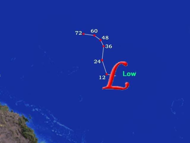
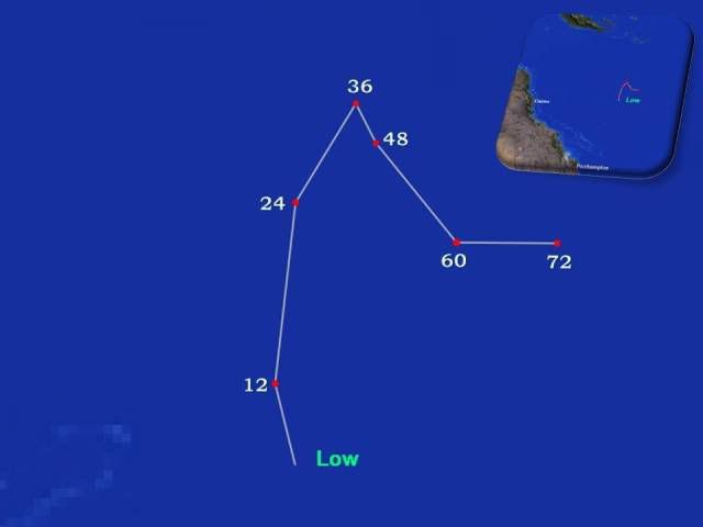
Using Eye of the Storm and PowePoint to put a map to the numbers!!!
0 likes   

User avatar
HURAKAN
Professional-Met
Professional-Met
Posts: 46086
Age: 37
Joined: Thu May 20, 2004 4:34 pm
Location: Key West, FL
Contact:

#14 Postby HURAKAN » Thu Mar 19, 2009 8:02 pm

TROPICAL CYCLONE TECHNICAL BULLETIN: AUSTRALIA - EASTERN REGION
Issued by BRISBANE TROPICAL CYCLONE WARNING CENTRE
at: 0051 UTC 20/03/2009
Name: Tropical Low
Identifier: 19U
Data At: 0000 UTC
Latitude: 17.3S
Longitude: 153.0E
Location Accuracy: within 30 nm [55 km]
Movement Towards: west northwest [285 deg]
Speed of Movement: 16 knots [29 km/h]
Maximum 10-Minute Wind: 25 knots [45 km/h]
Maximum 3-Second Wind Gust: 35 knots [65 km/h]
Central Pressure: 1000 hPa
Radius of 34-knot winds NE quadrant:
Radius of 34-knot winds SE quadrant:
Radius of 34-knot winds SW quadrant:
Radius of 34-knot winds NW quadrant:
Radius of 48-knot winds NE quadrant:
Radius of 48-knot winds SE quadrant:
Radius of 48-knot winds SW quadrant:
Radius of 48-knot winds NW quadrant:
Radius of 64-knot winds:
Radius of Maximum Winds: n/a
Dvorak Intensity Code: T1.5/2.0/S0.0/24HRS
Pressure of outermost isobar: 1002 hPa
Radius of outermost closed isobar: 150 nm [280 km]
Storm Depth: Shallow
FORECAST DATA
Date/Time : Location : Loc. Accuracy: Max Wind : Central Pressure
[UTC] : degrees : nm [km]: knots[km/h]: hPa
+12: 20/1200: 16.9S 152.9E: 060 [110]: 030 [055]: 996
+24: 21/0000: 16.0S 153.0E: 090 [165]: 030 [055]: 997
+36: 21/1200: 15.5S 153.3E: 120 [225]: 035 [065]: 993
+48: 22/0000: 15.7S 153.4E: 155 [285]: 045 [085]: 987
+60: 22/1200: 16.2S 153.8E: 200 [375]: 060 [110]: 975
+72: 23/0000: 16.2S 154.3E: 250 [465]: 065 [120]: 973
REMARKS:
Low level circulation represented on Quickscat with deep convection and possible
mid-level circulation located about 2 degrees to the southeast. Surface obs
support the Qscat position.

Some interaction with an upper trough presently so shear to south of system is
having an influence.

Slow movement is expected over the next 72 hours and the environment is likely
to become favourable for some development in 12 to 36 hours.

DT unobtainable, FT of 1.5 based on MET with steady trend over 24 hours.

Technical Bulletin will continue to be sent due to expected redevelopment.

Copyright Commonwealth of Australia
==
The next bulletin for this system will be issued by: 20/0700 UTC by Brisbane
TCWC.
0 likes   

User avatar
HURAKAN
Professional-Met
Professional-Met
Posts: 46086
Age: 37
Joined: Thu May 20, 2004 4:34 pm
Location: Key West, FL
Contact:

#15 Postby HURAKAN » Thu Mar 19, 2009 8:13 pm

Image
0 likes   

User avatar
KWT
Category 5
Category 5
Posts: 31390
Joined: Tue Aug 17, 2004 11:02 am
Location: UK!!!

#16 Postby KWT » Thu Mar 19, 2009 9:00 pm

Track outside of 36hrs seems pretty uncertain it seems thanks to the weak steering currents which are present at the moment. Does seem like shear is holding up development of 98P.
0 likes   

User avatar
HURAKAN
Professional-Met
Professional-Met
Posts: 46086
Age: 37
Joined: Thu May 20, 2004 4:34 pm
Location: Key West, FL
Contact:

#17 Postby HURAKAN » Fri Mar 20, 2009 6:00 am

TROPICAL CYCLONE TECHNICAL BULLETIN: AUSTRALIA - EASTERN REGION
Issued by BRISBANE TROPICAL CYCLONE WARNING CENTRE
at: 0638 UTC 20/03/2009
Name: Tropical Low
Identifier: 19U
Data At: 0600 UTC
Latitude: 17.1S
Longitude: 153.5E
Location Accuracy: within 30 nm [55 km]
Movement Towards: east northeast [067 deg]
Speed of Movement: 5 knots [10 km/h]
Maximum 10-Minute Wind: 25 knots [45 km/h]
Maximum 3-Second Wind Gust: 35 knots [65 km/h]
Central Pressure: 1000 hPa
Radius of 34-knot winds NE quadrant:
Radius of 34-knot winds SE quadrant:
Radius of 34-knot winds SW quadrant:
Radius of 34-knot winds NW quadrant:
Radius of 48-knot winds NE quadrant:
Radius of 48-knot winds SE quadrant:
Radius of 48-knot winds SW quadrant:
Radius of 48-knot winds NW quadrant:
Radius of 64-knot winds:
Radius of Maximum Winds: n/a
Dvorak Intensity Code: T1.5/1.5/S0.0/24HRS
Pressure of outermost isobar: 1002 hPa
Radius of outermost closed isobar: 90 nm [165 km]
Storm Depth: Shallow
FORECAST DATA
Date/Time : Location : Loc. Accuracy: Max Wind : Central Pressure
[UTC] : degrees : nm [km]: knots[km/h]: hPa
+12: 20/1800: 16.5S 153.0E: 060 [110]: 025 [045]: 1000
+24: 21/0600: 15.9S 153.0E: 090 [165]: 025 [045]: 998
+36: 21/1800: 15.4S 153.2E: 120 [225]: 030 [055]: 997
+48: 22/0600: 15.2S 153.2E: 155 [285]: 030 [055]: 996
+60: 22/1800: 14.7S 153.6E: 200 [375]: 040 [075]: 990
+72: 23/0600: 14.7S 154.3E: 250 [465]: 055 [100]: 975
REMARKS:
A complex broad area of low pressure exists in the Coral Sea with no well
defined centres.

Some interaction with an upper trough presently so shear to south of system is
having an influence, this is expected to weaken in the next 24 hours.

Slow movement is expected over the next 72 hours and the environment is likely
to become favourable for some development in 24 to 48 hours.

DT unobtainable, FT of 1.5 based on MET with steady trend over 24 hours.

This will be the last Technical Bulletin unless the system intensifies.

Copyright Commonwealth of Australia
0 likes   

User avatar
HURAKAN
Professional-Met
Professional-Met
Posts: 46086
Age: 37
Joined: Thu May 20, 2004 4:34 pm
Location: Key West, FL
Contact:

#18 Postby HURAKAN » Fri Mar 20, 2009 12:03 pm

Australian Government Bureau of Meteorology
Queensland
Tropical Cyclone Warning Centre

Media: This message is issued daily for the information of interested parties.
Media are NOT required to broadcast this message.

TROPICAL CYCLONE OUTLOOK
for the Coral Sea West of Longitude 160 East
Issued at 2:30pm on Friday the 20th of March 2009

The monsoon trough extends across far northern Cape York Peninsula and the
northern Coral Sea. A low with central pressure approximately 1000 hPa lies over
the Coral Sea near 17S 153E. This low is expected to deepen further over the
next few days while remaining slow moving.

The probability of this system becoming a tropical cyclone over the next three
days is:

Saturday: Moderate
Sunday: High
Monday: High

Tropical Cyclone outlooks issued by Brisbane can be accessed through the
Bureau's Home Page http://www.bom.gov.au.

Please note that the Darwin Regional Forecasting Centre issues Tropical Cyclone
Outlooks that cover the Gulf of Carpentaria. Refer to the Northern Region and
Gulf 3 day outlook at http://www.bom.gov.au/weather/cyclone/tc-outlooks.shtml.
0 likes   

User avatar
HURAKAN
Professional-Met
Professional-Met
Posts: 46086
Age: 37
Joined: Thu May 20, 2004 4:34 pm
Location: Key West, FL
Contact:

#19 Postby HURAKAN » Fri Mar 20, 2009 11:38 pm

Image
0 likes   

User avatar
HURAKAN
Professional-Met
Professional-Met
Posts: 46086
Age: 37
Joined: Thu May 20, 2004 4:34 pm
Location: Key West, FL
Contact:

#20 Postby HURAKAN » Sat Mar 21, 2009 7:27 am

Australian Government Bureau of Meteorology
Queensland
Tropical Cyclone Warning Centre

Media: This message is issued daily for the information of interested parties.
Media are NOT required to broadcast this message.

TROPICAL CYCLONE OUTLOOK
for the Coral Sea West of Longitude 160 East
Issued at 2:30pm on Saturday the 21st of March 2009

The monsoon trough extends across far northern Cape York Peninsula and the
northern Coral Sea. A low with central pressure approximately 999 hPa lies over
the Coral Sea near 22S 162E. This low is expected to deepen slightly and move
southeast during the next few days.

The probability of this system becoming a tropical cyclone over the next three
days is:

Saturday: Low
Sunday: Low
Monday: Low

Tropical Cyclone outlooks issued by Brisbane can be accessed through the
Bureau's Home Page http://www.bom.gov.au.

Please note that the Darwin Regional Forecasting Centre issues Tropical Cyclone
Outlooks that cover the Gulf of Carpentaria. Refer to the Northern Region and
Gulf 3 day outlook at http://www.bom.gov.au/weather/cyclone/tc-outlooks.shtml.
0 likes   


Return to “2009”

Who is online

Users browsing this forum: No registered users and 125 guests