Coral Sea: JASPER - Tropical Cyclone
Moderator: S2k Moderators


-
HURAKAN

- Professional-Met

- Posts: 46086
- Age: 37
- Joined: Thu May 20, 2004 4:34 pm
- Location: Key West, FL
- Contact:
Australian Government Bureau of Meteorology
Queensland
Tropical Cyclone Warning Centre
TROPICAL CYCLONE INFORMATION BULLETIN
For 6:30am AEST on Tuesday the 24th of March 2009
At 4 am EST Tuesday, Tropical Cyclone Jasper [Category 1] with central pressure
995 hPa was located near latitude 17.6 south longitude 158.0 east, which is
about 1010 km east northeast of Mackay.
The cyclone is moving east southeast at about 32 kilometres per hour.
TROPICAL CYCLONE JASPER, CATEGORY 1, is located in the eastern Coral Sea well
away from the Queensland coast and is expected to maintain its current intensity
as it moves to the southeast. TROPICAL CYCLONE JASPER poses NO IMMEDIATE THREAT
to people in coastal and island communities along the Queensland coast.
The next Information Bulletin will be issued by 11 am EST today.
0 likes
-
HURAKAN
- Professional-Met
- Posts: 46086
- Age: 37
- Joined: Thu May 20, 2004 4:34 pm
- Location: Key West, FL
- Contact:
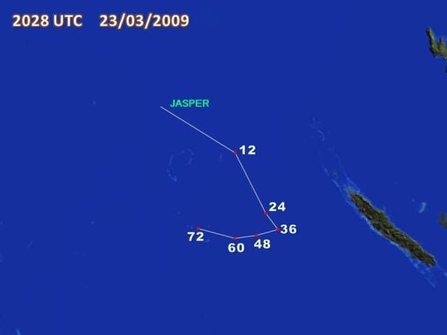
TROPICAL CYCLONE TECHNICAL BULLETIN: AUSTRALIA - EASTERN REGION
Issued by BRISBANE TROPICAL CYCLONE WARNING CENTRE
at: 2028 UTC 23/03/2009
Name: Tropical Cyclone Jasper
Identifier: 20U
Data At: 1800 UTC
Latitude: 17.6S
Longitude: 158.0E
Location Accuracy: within 60 nm [110 km]
Movement Towards: east southeast [110 deg]
Speed of Movement: 17 knots [32 km/h]
Maximum 10-Minute Wind: 40 knots [75 km/h]
Maximum 3-Second Wind Gust: 55 knots [100 km/h]
Central Pressure: 995 hPa
Radius of 34-knot winds NE quadrant: 90 nm [165 km]
Radius of 34-knot winds SE quadrant: 120 nm [220 km]
Radius of 34-knot winds SW quadrant: 180 nm [335 km]
Radius of 34-knot winds NW quadrant: 60 nm [110 km]
Radius of 48-knot winds NE quadrant:
Radius of 48-knot winds SE quadrant:
Radius of 48-knot winds SW quadrant:
Radius of 48-knot winds NW quadrant:
Radius of 64-knot winds:
Radius of Maximum Winds: 30 nm [55 km]
Dvorak Intensity Code: T3.0/3.0/D1.5/24HRS
Pressure of outermost isobar: 1002 hPa
Radius of outermost closed isobar: 90 nm [165 km]
Storm Depth: Deep
FORECAST DATA
Date/Time : Location : Loc. Accuracy: Max Wind : Central Pressure
[UTC] : degrees : nm [km]: knots[km/h]: hPa
+12: 24/0600: 19.1S 160.4E: 090 [165]: 040 [075]: 991
+24: 24/1800: 21.0S 161.6E: 120 [220]: 040 [075]: 990
+36: 25/0600: 21.5S 161.8E: 150 [280]: 040 [075]: 987
+48: 25/1800: 21.7S 161.1E: 185 [345]: 040 [075]: 988
+60: 26/0600: 21.8S 160.4E: 230 [430]: 040 [075]: 987
+72: 26/1800: 21.5S 159.2E: 280 [520]: 040 [075]: 988
REMARKS:
DT shear pattern with 0.5 of a degree separation from deep convection gives 3.0
based on EIR. Upper trough over the Coral Sea expected to keep the system moving
to the southeast for at least the next 24 hours.
Copyright Commonwealth of Australia
==
The next bulletin for this system will be issued by: 24/0100 UTC by Brisbane
0 likes
-
HURAKAN
- Professional-Met
- Posts: 46086
- Age: 37
- Joined: Thu May 20, 2004 4:34 pm
- Location: Key West, FL
- Contact:
HIGH SEAS WEATHER WARNING FOR METAREA 10 ISSUED BY THE AUSTRALIAN BUREAU OF
METEOROLOGY, BRISBANE 2038 UTC 23 March 2009
GALE WARNING FOR NORTH EASTERN AREA
SITUATION
At 1800 UTC Tropical Cyclone Jasper was centred within 60 nautical miles of
latitude seventeen decimal six south [17.6S]
longitude one hundred and fifty eight decimal zero east [158.0E]
Recent movement : east southeast at 17 knots
Maximum winds : 40 knots
Central pressure: 995 hPa
AREA AFFECTED
Within 90 nautical miles in NE quadrant
and within 120 nautical miles in SE quadrant
and within 180 nautical miles in SW quadrant
and within 60 nautical miles in NW quadrant.
FORECAST
Maximum winds to 40 knots near the centre.
Winds above 34 knots within 90 nautical miles in NE quadrant
and within 120 nautical miles in SE quadrant
and within 180 nautical miles in SW quadrant
and within 60 nautical miles in NW quadrant with very rough seas and moderate
swell.
Forecast positions
At 0600 UTC 24 March: Within 90 nautical miles of 19.1 south 160.4 east
Central pressure 991 hPa.
Winds to 40 knots near centre
At 1800 UTC 24 March: Within 120 nautical miles of 21.0 south 161.6 east
Central pressure 990 hPa.
Winds to 40 knots
REMARKS
All ships in the area please send weather reports every three hours.
Regular weather observing ships use normal channels.
Other ships please use either email to marwxqld@bom.gov.au or fax to
+61732398776 or satellite to SAC 1241 through Land Earth Station Perth 212.
Next warning will be issued by 0100 UTC 24 March 2009.
WEATHER BRISBANE
0 likes
-
HURAKAN
- Professional-Met
- Posts: 46086
- Age: 37
- Joined: Thu May 20, 2004 4:34 pm
- Location: Key West, FL
- Contact:
TROPICAL CYCLONE TECHNICAL BULLETIN: AUSTRALIA - EASTERN REGION
Issued by BRISBANE TROPICAL CYCLONE WARNING CENTRE
at: 2357 UTC 23/03/2009
Name: Tropical Cyclone Jasper
Identifier: 20U
Data At: 2200 UTC
Latitude: 17.3S
Longitude: 158.7E
Location Accuracy: within 40 nm [75 km]
Movement Towards: southeast [130 deg]
Speed of Movement: 10 knots [19 km/h]
Maximum 10-Minute Wind: 50 knots [95 km/h]
Maximum 3-Second Wind Gust: 70 knots [130 km/h]
Central Pressure: 985 hPa
Radius of 34-knot winds NE quadrant: 240 nm [445 km]
Radius of 34-knot winds SE quadrant: 300 nm [555 km]
Radius of 34-knot winds SW quadrant: 300 nm [555 km]
Radius of 34-knot winds NW quadrant: 240 nm [445 km]
Radius of 48-knot winds NE quadrant: 0 nm [0 km]
Radius of 48-knot winds SE quadrant: 240 nm [445 km]
Radius of 48-knot winds SW quadrant: 240 nm [445 km]
Radius of 48-knot winds NW quadrant: 0 nm [0 km]
Radius of 64-knot winds:
Radius of Maximum Winds: 150 nm [280 km]
Dvorak Intensity Code: T3.5/3.5/D1.5/24HRS
Pressure of outermost isobar: 1000 hPa
Radius of outermost closed isobar: 100 nm [185 km]
Storm Depth: Deep
FORECAST DATA
Date/Time : Location : Loc. Accuracy: Max Wind : Central Pressure
[UTC] : degrees : nm [km]: knots[km/h]: hPa
+12: 24/1000: 18.9S 160.5E: 070 [130]: 055 [100]: 978
+24: 24/2200: 20.5S 161.8E: 100 [185]: 060 [110]: 975
+36: 25/1000: 20.9S 161.5E: 130 [245]: 070 [130]: 962
+48: 25/2200: 21.2S 160.8E: 165 [305]: 075 [140]: 956
+60: 26/1000: 21.1S 159.9E: 210 [395]: 080 [150]: 950
+72: 26/2200: 19.9S 158.1E: 260 [480]: 085 [155]: 945
REMARKS:
CDO pattern with possible 0.5 banding feature based on GMS-5 2130UTC VIS and IR,
yielding a DT of 3.5. Upper trough over the Coral Sea expected to move the
system to the southeast for at least the next 24 hours. Quikscat at 22:52UTC
shows 50 knot winds in the southern semicircle [most, but not all, rain
affected].
Copyright Commonwealth of Australia
==
The next bulletin for this system will be issued by: 24/0500 UTC by Brisbane
TCWC.
0 likes
-
HURAKAN
- Professional-Met
- Posts: 46086
- Age: 37
- Joined: Thu May 20, 2004 4:34 pm
- Location: Key West, FL
- Contact:
TPPS10 PGTW 240007
A. TROPICAL DISTURBANCE 98P (NE OF AUSTRALIA)
B. 23/2330Z
C. 17.4S
D. 159.1E
E. FIVE/MTSAT
F. T2.5/2.5 STT: D0.5/03HRS
G. IR/EIR/VIS/MSI
H. REMARKS: 40A/PBO SBC/ANMTN. CNVCTN WRAP OF 0.40 ON LOG10
SPIRAL YIELDS A DT OF 2.5. PT AGREES. DBO DT.
I. ADDITIONAL POSITIONS:
23/1821Z 16.8S 158.2E AMSU
23/1938Z 17.0S 158.4E SSMI
23/2037Z 16.9S 158.7E SSMS
UEHARA
0 likes

Tropical Disturbance Summary For area Equator to 25S, 160E to 120W
ISSUED FROM RSMC NADI Mar 23/2318 UTC 2009 UTC.
TROPICAL CYCLONE JASPER [990HPA] CATEGORY 1 CENTRE WAS LOCATED NEAR
17 DECIMAL 6 SOUTH 158 DECIMAL 0 EAST AT 231800 UTC. POSITION FAIR.
CYCLONE MOVING EAST-SOUTHEAST AT ABOUT 17 KNOTS.
TC JASPER IS EXPECTED TO MOVE INTO NADI-RSMC AREA OF RESPONSIBILITY
IN THE NEXT 6 TO 12 HOURS AND IS FORECAST TO BE NEAR 19.1S 160.4E AT
240600 UTC AND NEAR 21.0S 161.6E AT 241800 UTC.
THERE ARE NO OTHER SIGNIFICANT TROPICAL DISTURBANCES ANALYSED OR
FORECAST IN THE AREA.
0 likes
Quite a bit difference between the first forecast when Jasper formed and the newest one which shows Jasper getting upto 85kts, much depends on whether that mod-high shear can stay away from Jasper, but for now it has improved quite a lot recently in terms of presentation, just needed the deeper convection to wrap into the circulation which is what has happened over the last 12hrs.
0 likes

-
HURAKAN
- Professional-Met
- Posts: 46086
- Age: 37
- Joined: Thu May 20, 2004 4:34 pm
- Location: Key West, FL
- Contact:

WTPS31 PGTW 240300
MSGID/GENADMIN/NAVMARFCSTCEN PEARL HARBOR HI/JTWC//
SUBJ/TROPICAL CYCLONE 23P (JASPER) WARNING NR 001//
RMKS/
1. TROPICAL CYCLONE 23P (JASPER) WARNING NR 001
01 ACTIVE TROPICAL CYCLONE IN SOUTHPAC
MAX SUSTAINED WINDS BASED ON ONE-MINUTE AVERAGE
---
WARNING POSITION:
240000Z --- NEAR 17.3S 159.2E
MOVEMENT PAST SIX HOURS - 115 DEGREES AT 13 KTS
POSITION ACCURATE TO WITHIN 060 NM
POSITION BASED ON CENTER LOCATED BY SATELLITE
PRESENT WIND DISTRIBUTION:
MAX SUSTAINED WINDS - 035 KT, GUSTS 045 KT
WIND RADII VALID OVER OPEN WATER ONLY
REPEAT POSIT: 17.3S 159.2E
---
FORECASTS:
12 HRS, VALID AT:
241200Z --- 18.2S 160.6E
MAX SUSTAINED WINDS - 045 KT, GUSTS 055 KT
WIND RADII VALID OVER OPEN WATER ONLY
RADIUS OF 034 KT WINDS - 060 NM NORTHEAST QUADRANT
065 NM SOUTHEAST QUADRANT
060 NM SOUTHWEST QUADRANT
050 NM NORTHWEST QUADRANT
VECTOR TO 24 HR POSIT: 155 DEG/ 06 KTS
---
24 HRS, VALID AT:
250000Z --- 19.3S 161.2E
MAX SUSTAINED WINDS - 055 KT, GUSTS 070 KT
WIND RADII VALID OVER OPEN WATER ONLY
RADIUS OF 050 KT WINDS - 025 NM NORTHEAST QUADRANT
030 NM SOUTHEAST QUADRANT
025 NM SOUTHWEST QUADRANT
025 NM NORTHWEST QUADRANT
RADIUS OF 034 KT WINDS - 070 NM NORTHEAST QUADRANT
075 NM SOUTHEAST QUADRANT
070 NM SOUTHWEST QUADRANT
060 NM NORTHWEST QUADRANT
VECTOR TO 36 HR POSIT: 225 DEG/ 04 KTS
---
36 HRS, VALID AT:
251200Z --- 19.9S 160.6E
MAX SUSTAINED WINDS - 060 KT, GUSTS 075 KT
WIND RADII VALID OVER OPEN WATER ONLY
RADIUS OF 050 KT WINDS - 030 NM NORTHEAST QUADRANT
035 NM SOUTHEAST QUADRANT
035 NM SOUTHWEST QUADRANT
030 NM NORTHWEST QUADRANT
RADIUS OF 034 KT WINDS - 075 NM NORTHEAST QUADRANT
080 NM SOUTHEAST QUADRANT
080 NM SOUTHWEST QUADRANT
075 NM NORTHWEST QUADRANT
VECTOR TO 48 HR POSIT: 295 DEG/ 07 KTS
---
EXTENDED OUTLOOK:
48 HRS, VALID AT:
260000Z --- 19.3S 159.3E
MAX SUSTAINED WINDS - 065 KT, GUSTS 080 KT
WIND RADII VALID OVER OPEN WATER ONLY
RADIUS OF 050 KT WINDS - 030 NM NORTHEAST QUADRANT
035 NM SOUTHEAST QUADRANT
035 NM SOUTHWEST QUADRANT
030 NM NORTHWEST QUADRANT
RADIUS OF 034 KT WINDS - 080 NM NORTHEAST QUADRANT
085 NM SOUTHEAST QUADRANT
085 NM SOUTHWEST QUADRANT
080 NM NORTHWEST QUADRANT
---
REMARKS:
240300Z POSITION NEAR 17.5S 159.6E.
TROPICAL CYCLONE (TC) 23P (JASPER), LOCATED APPROXIMATELY 505 NM
NORTHWEST OF NOUMEA, NEW CALEDONIA, HAS TRACKED EAST-SOUTHEASTWARD
AT 13 KNOTS OVER THE PAST SIX HOURS. DVORAK SATELLITE INTENSITY
ESTIMATES OF 2.5 FROM PGTW AND 3.0 FROM ABRF AND CONSOLIDATING
STRUCTURE EVIDENT IN RECENT MICROWAVE SATELLITE IMAGERY AND
SCATTEROMETER DATA INDICATE THAT TC 23P HAS FORMED. THE CYCLONE IS
TRACKING EAST-SOUTHEASTWARD ALONG THE WESTERN PERIPHERY OF A
SUBTROPICAL STEERING RIDGE. THIS GENERAL MOTION IS EXPECTED TO
CONTINUE THROUGH THE NEXT 12 HOURS. THEREAFTER, A SECOND SUBTROPICAL
RIDGE TO THE SOUTHWEST WILL INDUCE A COMPETING STEERING INFLUENCE,
SLOWING FORWARD TRACK MOTION AND TURNING THE SYSTEM NORTHWESTWARD
AFTER TAU 36. THE NUMERICAL MODEL TRACKERS, WITH THE EXCEPTION OF
WBAR AND GFDN, ARE IN FAIR AGREEMENT WITH THIS SCENARIO. HOWEVER,
DEPICTIONS OF THE EXACT TRACK VARY, AND THE CURRENT FORECAST LIES
CLOSE TO THE MODEL CONSENSUS. TC 23P IS EXPECTED TO INTENSIFY
THROUGHOUT THE FORECAST PERIOD UNDER THE INFLUENCE OF DUAL-CHANNEL
UPPER LEVEL OUTFLOW. INCREASING VERTICAL WIND SHEAR AFTER TAU 24
SHOULD LIMIT THIS INTENSIFICATION TO A SLOWER RATE. THIS WARNING
SUPERSEDES AND CANCELS REF A, NAVMARFCSTCEN 232151Z MAR 09 TROPICAL
CYCLONE FORMATION ALERT (WTPS21 PGTW 232200). MAXIMUM SIGNIFICANT
WAVE HEIGHT AT 240000Z IS 12 FEET. NEXT WARNINGS AT 241500Z AND
250300Z.//
NNNN
0 likes


-
Grifforzer
- Category 1

- Posts: 418
- Joined: Thu Feb 26, 2009 11:27 pm
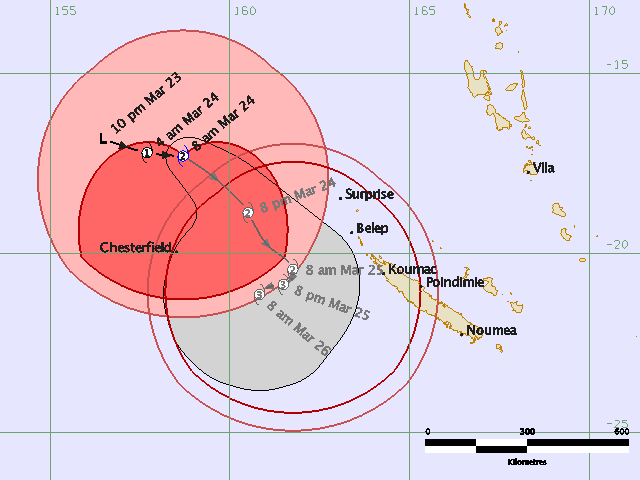
Tropical Cyclone Warning Center Brisbane
High Seas Warning
TROPICAL CYCLONE JASPER (CAT 2)
2:50 PM EST March 24 2009
===========================
At 2:00 PM EST, Tropical Cyclone Jasper, Category Two [985 hPa] located at 18.7S 160.1E has 10 minute sustained winds of 50 knots with gusts of 70 knots. The cyclone is reported as moving southeast at 14 knots.
Storm Force Winds
===============
100 NM northeast quadrant
240 NM southeast quadrant
240 NM northwest quadrant
100 NM southwest quadrant
Gale Force Winds
================
240 NM northeast quadrant
300 NM southeast quadrant
300 NM northwest quadrant
240 NM southwest quadrant
Dvorak Intensity: T3.0/3.5/D2.0/24HRS
Forecast and Intensity
=======================
12 HRS: 20.5S 161.5E - 60 knots (CAT 2)
24 HRS: 21.3S 162.0E - 65 knots (CAT 3)
48 HRS: 21.7S 160.9E - 75 knots (CAT 3)
72 HRS: 20.0S 157.7E - 85 knots (CAT 3)
Remarks:
============
Irregular VIS CDO 1.6 degrees in diameter yields DT3.0. MET and PAT suggest 2.5. DT used as final T. Expect SE steering to continue for 18 to 24 hours before a competing influence slows the system and ultimately turns it westward.
NEXT TROPICAL CYCLONE WARNING WILL BE ISSUED BY RSMC NADI..
-----------------------------------------------------
http://www.webcitation.org/5fVUXatHz - BOM official bulletin link
0 likes
-
Grifforzer
- Category 1
- Posts: 418
- Joined: Thu Feb 26, 2009 11:27 pm
From RSMC Nadi Gale Warning
Gale Warning 037 ISSUED FROM RSMC NADI Mar 24/0202 UTC 2009 UTC.
Tropical Cyclone Jasper [985hPa] CATEGORY 2 centre was located near
17 decimal 5 south 159 decimal 1 east at 240000 UTC.
Position Fair.
Repeat position 17.5S 159.1E at 240000 UTC.
Cyclone moving southeast at about 10 knots.
Expect sustained winds of 50 knots close to the centre.
Expect winds over 47 knots within 240 nautical miles of centre in the
southeastern semicircle.
Expect winds over 33 knots within 240 nautical miles of centre in the
northwestern semicircle and within 300 nautical miles in the
southeastern semicircle.
Forecast position near 19.2S 160.7 E at 241200 UTC
and near 20.5S 161.7 E at 250000 UTC.
0 likes
-
Grifforzer
- Category 1
- Posts: 418
- Joined: Thu Feb 26, 2009 11:27 pm
RSMC Nadi Hurricane Warning
HURRICANE WARNING 038 ISSUED FROM RSMC NADI Mar 24/0708 UTC 2009 UTC.
TROPICAL CYCLONE JASPER [980HPA] CATEGORY 2 CENTRE WAS LOCATED NEAR 19 DECIMAL 2
SOUTH 160 DECIMAL 4 EAST AT 240600 UTC.
POSITION FAIR.
REPEAT POSITION 19.2S 160.4E AT 240600 UTC.
CYCLONE MOVING SOUTHEAST AT ABOUT 14 KNOTS.
EXPECT SUSTAINED WINDS OF 55 KNOTS CLOSE TO THE CENTRE INCREASING TO 65 KNOTS IN
THE NEXT 12 TO 24 HOURS.
EXPECT WINDS OVER 47 KNOTS WITHIN 100 NAUTICAL MILES IN THE NORTHERN SEMICIRCLE
AND WITHIN 240 NAUTICAL MILES OF CENTRE IN THE SOUTHERN SEMICIRCLE.
EXPECT WINDS OVER 33 KNOTS WITHIN 240 NAUTICAL MILES OF CENTRE IN THE NORTHERN
SEMICIRCLE AND WITHIN 300 NAUTICAL MILES IN THE SOUTHERN SEMICIRCLE.
FORECAST POSITION NEAR 20.2S 161.3E AT 241800 UTC
AND NEAR 21.0S 161.3E AT 250600 UTC.
0 likes
-
HURAKAN
- Professional-Met
- Posts: 46086
- Age: 37
- Joined: Thu May 20, 2004 4:34 pm
- Location: Key West, FL
- Contact:
TROPICAL CYCLONE TECHNICAL BULLETIN: AUSTRALIA - EASTERN REGION
Issued by BRISBANE TROPICAL CYCLONE WARNING CENTRE
at: 0446 UTC 24/03/2009
Name: Tropical Cyclone Jasper
Identifier: 20U
Data At: 0400 UTC
Latitude: 18.7S
Longitude: 160.1E
Location Accuracy: within 40 nm [75 km]
Movement Towards: southeast [135 deg]
Speed of Movement: 14 knots [26 km/h]
Maximum 10-Minute Wind: 50 knots [95 km/h]
Maximum 3-Second Wind Gust: 70 knots [130 km/h]
Central Pressure: 985 hPa
Radius of 34-knot winds NE quadrant: 240 nm [445 km]
Radius of 34-knot winds SE quadrant: 300 nm [555 km]
Radius of 34-knot winds SW quadrant: 300 nm [555 km]
Radius of 34-knot winds NW quadrant: 240 nm [445 km]
Radius of 48-knot winds NE quadrant: 100 nm [185 km]
Radius of 48-knot winds SE quadrant: 240 nm [445 km]
Radius of 48-knot winds SW quadrant: 240 nm [445 km]
Radius of 48-knot winds NW quadrant: 100 nm [185 km]
Radius of 64-knot winds:
Radius of Maximum Winds: 35 nm [65 km]
Dvorak Intensity Code: T3.0/3.5/D2.0/24HRS
Pressure of outermost isobar: 1008 hPa
Radius of outermost closed isobar: 215 nm [400 km]
Storm Depth: Deep
FORECAST DATA
Date/Time : Location : Loc. Accuracy: Max Wind : Central Pressure
[UTC] : degrees : nm [km]: knots[km/h]: hPa
+12: 24/1600: 20.5S 161.5E: 070 [130]: 060 [110]: 976
+24: 25/0400: 21.3S 162.0E: 100 [185]: 065 [120]: 970
+36: 25/1600: 21.5S 161.4E: 130 [245]: 070 [130]: 959
+48: 26/0400: 21.7S 160.9E: 165 [305]: 075 [140]: 953
+60: 26/1600: 21.0S 159.0E: 210 [395]: 080 [150]: 948
+72: 27/0400: 20.0S 157.7E: 260 [480]: 085 [155]: 945
REMARKS:
Irregular VIS CDO 1.6 degrees in diameter yields DT3.0. MET and PAT suggest 2.5.
DT used as final T. Expect SE steering to continue for 18 to 24 hours before a
competing influence slows the system and ultimately turns it westward.
Copyright Commonwealth of Australia
==
The next bulletin for this system will be issued by Nadi TCWC.
0 likes

Who is online
Users browsing this forum: No registered users and 120 guests