what a tough call they have to make on this one... im not surprised they are hesitant... lol
this may bring about some new definitions and rules for naming... this will break some records if it gets named..
by the way ssts where this is at are quite a bit lower then where vince formed by about 10 degrees...
but the air aloft if much colder as Ortt said allowing for convection to form over rather cold waters..
NE of Azores Islands : INVEST 92L
Moderator: S2k Moderators
-
HURAKAN

- Professional-Met

- Posts: 46086
- Age: 37
- Joined: Thu May 20, 2004 4:34 pm
- Location: Key West, FL
- Contact:
592
ABNT20 KNHC 022333
TWOAT
TROPICAL WEATHER OUTLOOK
NWS TPC/NATIONAL HURRICANE CENTER MIAMI FL
800 PM EDT TUE JUN 2 2009
FOR THE NORTH ATLANTIC...CARIBBEAN SEA AND THE GULF OF MEXICO...
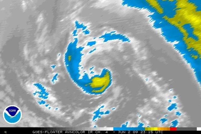
THE NON-TROPICAL AREA OF LOW PRESSURE CENTERED ABOUT 400 MILES
NORTH-NORTHEAST OF THE AZORES ISLANDS HAS CHANGED LITTLE IN
STRUCTURE TODAY. THE LOW...WHICH IS OVER WATER TEMPERATURES OF
NEAR 60 DEGREES...IS ACCOMPANIED BY WINDS OF 45-50 MPH CLOSE TO THE
CENTER BUT IS ASSOCIATED WITH ONLY LIMITED THUNDERSTORM ACTIVITY.
THE LOW HAS BEEN MEANDERING OVER THE PAST SEVERAL HOURS BUT IS
EXPECTED TO BEGIN AN EASTWARD MOTION TOMORROW AND GRADUALLY WEAKEN.
THERE IS A LOW CHANCE...LESS THAN 30 PERCENT...OF THIS SYSTEM
BECOMING A TROPICAL OR SUBTROPICAL CYCLONE DURING THE NEXT 48
HOURS.
ELSEWHERE...TROPICAL CYCLONE FORMATION IS NOT EXPECTED DURING THE
NEXT 48 HOURS.
$$
FORECASTER FRANKLIN
Bye, bye 92L. You're not going to get any better.
ABNT20 KNHC 022333
TWOAT
TROPICAL WEATHER OUTLOOK
NWS TPC/NATIONAL HURRICANE CENTER MIAMI FL
800 PM EDT TUE JUN 2 2009
FOR THE NORTH ATLANTIC...CARIBBEAN SEA AND THE GULF OF MEXICO...
THE NON-TROPICAL AREA OF LOW PRESSURE CENTERED ABOUT 400 MILES
NORTH-NORTHEAST OF THE AZORES ISLANDS HAS CHANGED LITTLE IN
STRUCTURE TODAY. THE LOW...WHICH IS OVER WATER TEMPERATURES OF
NEAR 60 DEGREES...IS ACCOMPANIED BY WINDS OF 45-50 MPH CLOSE TO THE
CENTER BUT IS ASSOCIATED WITH ONLY LIMITED THUNDERSTORM ACTIVITY.
THE LOW HAS BEEN MEANDERING OVER THE PAST SEVERAL HOURS BUT IS
EXPECTED TO BEGIN AN EASTWARD MOTION TOMORROW AND GRADUALLY WEAKEN.
THERE IS A LOW CHANCE...LESS THAN 30 PERCENT...OF THIS SYSTEM
BECOMING A TROPICAL OR SUBTROPICAL CYCLONE DURING THE NEXT 48
HOURS.
ELSEWHERE...TROPICAL CYCLONE FORMATION IS NOT EXPECTED DURING THE
NEXT 48 HOURS.
$$
FORECASTER FRANKLIN
Bye, bye 92L. You're not going to get any better.
0 likes
-
hurricanefloyd5

- Category 5

- Posts: 1659
- Age: 43
- Joined: Sun May 02, 2004 10:53 am
- Location: Spartanburg
- Contact:
Re:
Aric Dunn wrote:what a tough call they have to make on this one... im not surprised they are hesitant... lol
this may bring about some new definitions and rules for naming... this will break some records if it gets named..
by the way ssts where this is at are quite a bit lower then where vince formed by about 10 degrees...
but the air aloft if much colder as Ortt said allowing for convection to form over rather cold waters..
I think this should still b named.
0 likes
-
Category 5

- Category 5
- Posts: 10074
- Age: 34
- Joined: Sun Feb 11, 2007 10:00 pm
- Location: New Brunswick, NJ
- Contact:
Re:
CrazyC83 wrote:It pretty much looks like an unnamed hurricane...
Tropical Storm, not a Hurricane.
0 likes
-
DanieleItalyRm

- Category 1

- Posts: 486
- Age: 38
- Joined: Mon Sep 22, 2008 7:52 am
- Location: Rome - Italy - Mediterranean sea

-
cycloneye

- Admin

- Posts: 139083
- Age: 67
- Joined: Thu Oct 10, 2002 10:54 am
- Location: San Juan, Puerto Rico
Re: NE of Azores Islands : INVEST 92L
00 UTC Best Track
AL, 92, 2009060300, , BEST, 0, 447N, 247W, 45, 995, LO,
AL, 92, 2009060300, , BEST, 0, 447N, 247W, 45, 995, LO,
0 likes


-
wxman57

- Moderator-Pro Met

- Posts: 22482
- Age: 66
- Joined: Sat Jun 21, 2003 8:06 pm
- Location: Houston, TX (southwest)
Re: NE of Azores Islands : INVEST 92L
Just a big swirling low over water temps in the 50s. Won't be able to generate any significant convection near the center. Shouldn't be named or we'd be naming storms up there year round.
0 likes


-
DESTRUCTION5

- Category 5
- Posts: 4391
- Age: 42
- Joined: Wed Sep 03, 2003 11:25 am
- Location: Stuart, FL
Re: NE of Azores Islands : INVEST 92L
wxman57 wrote:Just a big swirling low over water temps in the 50s. Won't be able to generate any significant convection near the center. Shouldn't be named or we'd be naming storms up there year round.
Im not sure ive seen many of these all year round...At least ones that look like this...
0 likes


-
DanieleItalyRm
- Category 1
- Posts: 486
- Age: 38
- Joined: Mon Sep 22, 2008 7:52 am
- Location: Rome - Italy - Mediterranean sea
-
AJC3

- Admin
- Posts: 3873
- Age: 60
- Joined: Tue Aug 31, 2004 7:04 pm
- Location: West Melbourne, Florida
- Contact:
Re:
DanieleItalyRm wrote:Sorry but I am sure that they are waiting for it dissipation so they wont need to give it a name.
Yesterday and in this night the tropical caracteristics is evident.
This is a classic Azores low, of which one or two dozen form each year. While it has a fairly tight circulation, it's still a baroclinic cold core system, and I have yet to see enough persistent deep convection associated with this system for advisories to be initiated on it. It's pretty doubtful that the sporadic and rather shallow central convection that the system has been generating has injected enough latent heat into the core for any significant (read: weak, shallow at best...non-existent at worst) warm core to develop.
A system like this demonstrates that, once a system occludes to the point that it sheds all frontal characteristics, the line between extratropical and subtropical can become fuzzy (read: subjective).
And the whole "I've seen worse systems named" argument doesn't hold water. "Crappy system B should be named because crappy system A was named" is a weak argument to begin with. Moreover, list an Azores system that had TC or STC advisories initiated on it, and there's a good chance I can dig up a satellite picture that has much more extensive cold-top central convection than this system has ever had.
0 likes
-
cycloneye
- Admin
- Posts: 139083
- Age: 67
- Joined: Thu Oct 10, 2002 10:54 am
- Location: San Juan, Puerto Rico
Re: NE of Azores Islands : INVEST 92L
000
ABNT20 KNHC 031137
TWOAT
TROPICAL WEATHER OUTLOOK
NWS TPC/NATIONAL HURRICANE CENTER MIAMI FL
800 AM EDT WED JUN 3 2009
FOR THE NORTH ATLANTIC...CARIBBEAN SEA AND THE GULF OF MEXICO...
THE NON-TROPICAL AREA OF LOW PRESSURE CENTERED ABOUT 425 MILES
NORTH-NORTHEAST OF THE AZORES CONTINUES TO PRODUCE WINDS TO GALE
FORCE...BUT THE ASSOCIATED SHOWER AND THUNDERSTORM ACTIVITY REMAINS
LIMITED. THE LOW IS EXPECTED TO REMAIN OVER VERY COLD WATER AND
GRADUALLY WEAKEN AS IT BEGINS TO MOVE EASTWARD LATER TODAY. THERE
IS A LOW CHANCE...LESS THAN 30 PERCENT...OF THIS SYSTEM BECOMING A
TROPICAL OR SUBTROPICAL CYCLONE DURING THE NEXT 48 HOURS.
ELSEWHERE...TROPICAL CYCLONE FORMATION IS NOT EXPECTED DURING THE
NEXT 48 HOURS.
$$
FORECASTER BERG
0 likes
-
hurricanefloyd5
- Category 5
- Posts: 1659
- Age: 43
- Joined: Sun May 02, 2004 10:53 am
- Location: Spartanburg
- Contact:
Re:
CrazyC83 wrote:It pretty much looks like an unnamed hurricane...
I am upset with the NHC they should have named it i mean it was an unnamed Hurricane for petesakes. yeah right an unname hurricane at level INVEST92l NICE.
0 likes


Re: Re:
AJC3 did a great job of explaining why this is not a tropical system much less a hurricane.
hurricanefloyd5 wrote:CrazyC83 wrote:It pretty much looks like an unnamed hurricane...
I am upset with the NHC they should have named it i mean it was an unnamed Hurricane for petesakes. yeah right an unname hurricane at level INVEST92l NICE.
0 likes
Who is online
Users browsing this forum: No registered users and 119 guests