
Last Advisory
000
WTNT35 KNHC 290842
TCPAT5
BULLETIN
TROPICAL DEPRESSION DANNY ADVISORY NUMBER 12
NWS TPC/NATIONAL HURRICANE CENTER MIAMI FL AL052009
500 AM EDT SAT AUG 29 2009
...DANNY RAPIDLY BECOMING ABSORBED BY AN EXTRATROPICAL LOW...
AT 5 AM EDT...0900 UTC...THE TROPICAL STORM WATCH FOR THE NORTH
CAROLINA COAST FROM CAPE LOOKOUT NORTHWARD TO DUCK...INCLUDING THE
PAMLICO AND ALBEMARLE SOUNDS HAS BEEN DISCONTINUED.
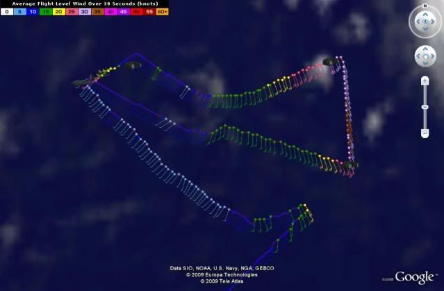
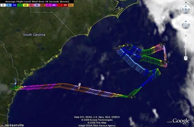
SATELLITE IMAGES AND DATA FROM AN AIR FORCE RECONNAISSANCE PLANE
INDICATE THAT DANNY IS RAPIDLY BECOMING ABSORBED BY AN
EXTRATROPICAL LOW OVER NORTH CAROLINA. AT 500 AM EDT...0900
UTC...THE REMNANTS OF DANNY WERE LOCATED NEAR LATITUDE 34.3
NORTH... LONGITUDE 74.6 WEST OR ABOUT 80 MILES...130 KM...SOUTHEAST
OF CAPE HATTERAS NORTH CAROLINA AND ABOUT 540 MILES...875
KM...SOUTH-SOUTHWEST OF NANTUCKET MASSACHUSETTS.
THE EXTRATROPICAL LOW IS FORECAST TO MOVE RAPIDLY TOWARD THE
NORTH-NORTHEAST AND THEN NORTHEAST NEAR 30 TO 35 MPH DURING THE NEXT
DAY OR SO.
MAXIMUM SUSTAINED WINDS ARE NEAR 35 MPH...55 KM/HR...WITH HIGHER
GUSTS.
ESTIMATED MINIMUM CENTRAL PRESSURE IS 1007 MB...29.74 INCHES.
LARGE SWELLS FROM THE EXTRATROPICAL LOW ARE EXPECTED TO PRODUCE
DANGEROUS SURF CONDITIONS AND LIFE-THREATENING RIP CURRENTS ALONG
THE U.S. EAST COAST DURING THE NEXT DAY OR TWO. PLEASE CONSULT
STATEMENTS ISSUED BY YOUR LOCAL NATIONAL WEATHER SERVICE FORECAST
OFFICE FOR MORE DETAILS.
...SUMMARY OF 500 AM EDT INFORMATION...
LOCATION...34.3N 74.6W
MAXIMUM SUSTAINED WINDS...35 MPH
PRESENT MOVEMENT...NORTH-NORTHEAST OR 20 DEGREES AT 30 MPH
MINIMUM CENTRAL PRESSURE...1007 MB
THIS IS THE LAST PUBLIC ADVISORY ISSUED BY THE NATIONAL HURRICANE
CENTER ON THIS SYSTEM. ADDITIONAL INFORMATION ON THIS SYSTEM CAN BE
FOUND IN HIGH SEAS FORECASTS ISSUED BY THE NATIONAL WEATHER
SERVICE...UNDER AWIPS HEADER NFDHSFAT1 AND WMO HEADER FZNT01 KWBC.
$$
FORECASTER AVILA
ATL: TROPICAL DEPRESSION DANNY (05L)
Moderator: S2k Moderators


-
otowntiger
- Category 5

- Posts: 1787
- Joined: Tue Aug 31, 2004 7:06 pm
- Location: Orlando
Re: ATL: TROPICAL DEPRESSION DANNY (05L)
wxman57 wrote:Only one thing left to say...
I agree and I think you need to go over to the 94L thread and administer last rites to it as well.
0 likes

Re: ATL: TROPICAL DEPRESSION DANNY (05L)
I would say that it was born dead. A very interesting but frustrating system it was.
0 likes

Re: ATL: TROPICAL DEPRESSION DANNY (05L)
Sanibel wrote:Dead? Pretty good IR for "dead"
It is more impressive now that it has been merged with the big extratropical system, but as a tropical one it is dead, it has re-incarnated if you want to see it that way.
0 likes


Danny's undead: "Danny is getting stronger, despite an official downgrade from tropical storm status"
http://www.accuweather.com/regional-new ... eastusnews
http://www.accuweather.com/regional-new ... eastusnews
Wind gusts of 40 to 60 mph will buffet the New England coast (especially on Cape Cod and the islands) into this evening, then diminish later tonight. The gusty winds will shift into the maritime provinces of Canada tonight and Sunday.
0 likes
-
vbhoutex

- Storm2k Executive

- Posts: 28974
- Age: 72
- Joined: Wed Oct 09, 2002 11:31 pm
- Location: Spring Branch area, Houston, TX
- Contact:
Re:
funster wrote:Danny's undead: "Danny is getting stronger, despite an official downgrade from tropical storm status"
http://www.accuweather.com/regional-new ... eastusnewsWind gusts of 40 to 60 mph will buffet the New England coast (especially on Cape Cod and the islands) into this evening, then diminish later tonight. The gusty winds will shift into the maritime provinces of Canada tonight and Sunday.
Is any of this supposed to be a surprise? Most of this was expected whatever form "Danny" was in when he reached this area. I have to stop there or punish myself for the rest of what I would post.
0 likes
-
Hybridstorm_November2001

- S2K Supporter

- Posts: 2802
- Joined: Sat Aug 21, 2004 2:50 pm
- Location: SW New Brunswick, Canada
- Contact:


Re: ATL: TROPICAL DEPRESSION DANNY (05L)
Heaviest Wind/Rain is coming through the Island right now. Might be gusting over 40mph.
0 likes
-
Maritimer71

- S2K Supporter
- Posts: 41
- Joined: Sun Aug 23, 2009 6:07 am
- Location: Nova Scotia - Canada
-
tropicana

- Category 5
- Posts: 8056
- Joined: Sat Sep 27, 2003 6:48 pm
- Location: Niagara Falls, Ontario, Canada
- Contact:
Re: ATL: TROPICAL DEPRESSION DANNY (Advisories)
Statements by the Canadian Hurricane Centre:-
WOCN31 CWHX 291200
Tropical storm Danny information statement issued by the
Canadian hurricane centre of Environment Canada at 9.00 AM ADT
Saturday 29 August 2009.
The next statement will be issued by 3.00 PM ADT
... Danny a weak tropical storm ...
At 9.00 AM ADT... Remnants of tropical storm Danny was located
Near latitude 35.0 N and longitude 73.6 W... About 100 nautical
Miles or 180 km (110miles) east of Cape Hatteras . Maximum sustained winds
Are estimated at 40 knots... 74 km/h (45mph) ... And central pressure
At 1004 MB. Danny is moving north northeast at 27 knots... 50 km/h.(30mph)
Rainfall warnings in effect over Southwestern New Brunswick
For amounts of 75 mm and over Southern Nova Scotia for 50 mm.
Elsewhere across the Maritimes.. Forecast amounts will be less
Than the 50 mm warning criteria. A rainfall warning will be
Posted over the Newfoundland south coast region for amounts
Just above 50 mm. The heavy rainfall will present driving hazards
For motorists.. Overflowing catch basins and ditches.
Winds warnings are not anticipated. However warnings for Les Suetes
over the Cape Breton Highlands of 110 km/h and Wreckhouse winds near
Port aux Basques of 100 km/h is anticipated.
Heavy swell associated with the storm may cause significant surf
And rip tides along the Atlantic coast of Nova Scotia. Caution
Should be observed by people near the coast.
Gale warnings are in effect for all maritime marine waters
Except the Laurentian fan. Gale warnings are in effect for
The western waters of the Newfoundland marine district.
Aircraft can not find any circulation nor gale force
Winds. Hence Miami has discontinued messaging as Danny becomes
absorbed by the extra-tropical low generated by the advancing
Upper trough from the deep south. Convection has become
Notable in the area off the Carolina coast where cyclogenesis
Will likely occur.
In their final message.. Miami carries an absorbed Danny
With the newly formed extra tropical low hence their final
Track is snapped westward.
At the CHC.. We will maintain Danny as a separate entity
For now based on the reasoning suggested in our previous
Message and repeated below. As well.. We prefer to see the
Latest quickscat and visual satellite imagery before
Discontinuing our messages.
Of note.. Even if we no longer reference Danny.. All
Of our public and marine forecasts were constructed last
Night based on dynamical modelling taking the influence
Of Danny into account. We doubt that there will be little
Change in the forecasts for the Maritimes and Newfoundland
Other than tweaking numbers based on newer dynamic models.
As mentioned in the previous message..
There are 3 separate weather entities.. A very marginal tropical
Storm.. The approaching upper trough from the american deep
South and the upper trough moving in from Ontario. Unfortunately
The Gem combined Danny and the southern upper trough hence it
generated an unrealistically deep and fast moving low that
Was west of our chosen track. One suspects that latent
Heating feedback is also an issue so the Gem was rejected.
The nam kept Danny as a weakening entity that can be followed
By the 576 thickness warm pool and the 500 MB vorticity
Through Newfoundland. As a result.. The nam provides the
Best template for the public and marine forecasts. The gfs
Resolution is too coarse to offer much help.
The effect of rainfall from Danny will mostly be confined
To Nova Scotia and Newfoundland. The very heavy rain over
New Brunswick is mostly caused by a moisture laden gulf
Of Mexico airmass carried by an upper trough from the
American deep south which rides over a warm frontal zone.
The nam model hints at local amounts of 100 mm there.
Storm surge should not be an issue due to neap tides this
Weekend and insufficient winds. Waves should be less
Than 8 metres offshore of Nova Scotia and less than 6
Into Newfoundland waters.
0 likes
-
tropicana
- Category 5
- Posts: 8056
- Joined: Sat Sep 27, 2003 6:48 pm
- Location: Niagara Falls, Ontario, Canada
- Contact:
Re: ATL: TROPICAL DEPRESSION DANNY (Advisories)
Statements by the CHC:-
Post-tropical storm Danny information statement issued by the
canadian hurricane centre of Environment Canada at 3.00 PM ADT
Saturday 29 August 2009.
...Post-tropical Danny tracking towards Southern Nova Scotia...
At 3.00 PM ADT... Post-tropical storm Danny was located near
Latitude 37.3 N and longitude 71.7 W... About 180 nautical miles
Or 335 km (205miles) east of Wallops Island . Maximum sustained winds are
Estimated at 40 knots... 74 km/h (45mph) ... And central pressure at 1002
MB. Danny is moving northeast at 41 knots... 76 km/h (47mph).
Rain at times heavy will reduce visibilities..Present driving
Hazards for motorists..And overflow catch basins and ditches.
Winds warnings are not anticipated. However warnings for Les Suetes
over the Cape Breton Highlands of 110 km/h and Wreckhouse winds near
Port aux Basques of 100 km/h are predicted.
Heavy swell associated with the storm may cause significant surf
And rip tides along the Atlantic coast of Nova Scotia. Caution
Should be observed by people near the coast.
Danny ended its transition to a post-tropical storm this morning.
Satellite pictures shows heavy convection in its vicinity
And quickscat shows the circulation expanded the gales far
Away from the centre. Dynamic support from the upper flow
Is driving the system which at this time continues to feed
From the warm sea surface.
Nhc in Miami stopped tracking post-tropical storm Danny
Early this morning. CHC forecasters will continue to maintain
Danny as a post-tropical entity until it moves out of the
Response zone on Monday.
Post-tropical storm Danny will move over colder water
Tonight as it passes near the Atlantic coast of Nova Scotia
Then track across Cape Breton Sunday morning.
It will pass over Southeastern Newfoundland late Sunday then
Move away over the Atlantic Sunday night and on Monday.
Canadian models indicate good upper support over the tropical
Airmass associated with Danny which moves ahead of low
Pressure system coming from the Great Lakes.
Past experience indicates that post-tropical storm Danny
Is likely to remain as an entity under those conditions.
The tropical nature of this system will produce rain at
Times heavy giving significant rainfall in a short period
Of time. Rainfall amounts of 50 mm and up to 100 mm are
Likely to fall over Nova Scotia..Pei and
Southern New Brunswick.
Heavy rainfall warnings are in effect for those regions.
Gale force winds are predicted over most of the maritime
And Newfoundland marine district.
0 likes
-
tropicana
- Category 5
- Posts: 8056
- Joined: Sat Sep 27, 2003 6:48 pm
- Location: Niagara Falls, Ontario, Canada
- Contact:
Re: ATL: TROPICAL DEPRESSION DANNY (Advisories)
Statements by the CHC:-
Post tropical Danny information statement issued by the canadian
hurricane centre of Environment Canada at 9.00 PM ADT Saturday
29 August 2009.
... Post-tropical storm moving towards the Atlantic coast
Of Nova Scotia ...
At 9.00 PM ADT... POST TROPICAL STORM DANNY was located near latitude
40.6 N and longitude 68.6 W... About 75 nautical miles or 140 km (85miles )
East southeast of Nantucket . Maximum sustained winds are
Estimated at 40 knots... 74 km/h. (45mph) .. And central pressure at 1002
MB. Danny is moving northeast at 24 knots... 44 km/h. (27mph)
Rainfall warnings are in effect for pei and Southern New Brunswick
for amounts of 50 mm with local amounts to 80. For northern new
Brunswick.. Rainfall amounts of 20 to 30 mm can be expected.
Rainfall warnings are continued for Nova Scotia for amounts of
50 to 70 mm with local amounts up to 100 mm.
Rainfall warnings are in effect for the Southwestern Newfoundland
regions for amounts near 50 mm.
Rain at times heavy will reduce visibilities..Present driving
Hazards for motorists..And overflow catch basins and ditches.
Wind warnings are not anticipated. However warnings for Les Suetes
over the Cape Breton Highlands of 110 km/h and Wreckhouse winds near
Port aux Basques of 100 km/h are predicted.
Heavy swell associated with the storm may cause significant surf
And rip tides along the Atlantic coast of Nova Scotia. Caution
Should be observed by people near the coast.
4. Marine weather impacts and warnings summary
Gale warnings are continued for all maritime marine waters
Except the Laurentian fan. Gale warnings are in effect for all
The Newfoundland waters except the Grand Banks.
5. Technical discussion for meteorologists
A. Analysis
Post-tropical storm Danny is located over warm water and
Lots of convection is associated with it causing heavy rain
From numerous thundershowers in the northeast and southeast
quadrants. We locate Danny near the cluster of lightning strokes
indicates by the lighnting detectors. Radar echoes are strong
Which indicates heavy rain. Some land stations are reporting
Heavy rainfall amounts as well.
B. Prognostic
Canadian hurricane centre forecasters will maintain Danny as
A post-tropical entity until it moves out of the response
Zone on Monday. Dynamic support from the upper flow is driving
The system which at this time continues to feed from the warm
Sea surface.
Canadian hurricane centre forecasters will maintain Danny as
A post-tropical entity until it moves out of the response
Zone on Monday. Dynamic support from the upper flow is driving
The system which at this time continues to feed from the warm
Sea surface.
Post-tropical storm Danny will move over colder water
Tonight as it passes near the Atlantic coast of Nova Scotia
Then track near Cape Breton Sunday afternoon.
It will pass over Southeastern Newfoundland late Sunday then
Move away over the Atlantic Sunday night and on Monday.
Canadian and us models indicate upper support over the tropical
airmass associated with Danny which moves ahead of low
Pressure system coming from the Great Lakes and the low pressure
centre currently near Cape Cod. Past experience indicates that
post-tropical storm Danny has the potential to remain as an entity
during the forecast period under those conditions.
Note that Danny will track further south than indicated in previous
messages based in keeping Danny separate from the vorticity
Support centre of the Cape Cod low.
Next statement at 3:00am ADT
0 likes
-
tropicana
- Category 5
- Posts: 8056
- Joined: Sat Sep 27, 2003 6:48 pm
- Location: Niagara Falls, Ontario, Canada
- Contact:
Re: ATL: TROPICAL DEPRESSION DANNY (Advisories)
FINAL STATEMENT from the CHC:-
Post tropical Danny information statement issued by the canadian
hurricane centre of Environment Canada at 3.00 AM ADT Sunday
30 August 2009.
... Danny absorbed into the maritime low pressure centre...
Post tropical storm Danny can not be detected on quickscat for 18
hours now. One was able to eye ball an area of convection
Southeast of cap cod and follow that cluster where Danny was suppose
To be.. But that relationship has fallen apart. The models
Still retains a very weak vort centre over the supposed
Position of Danny but after 12 zulu..The machine models lose
Its Resolution.
Thickness are still high surrounding the deep maritime low
Now moving through the Bay of Fundy. This no doubt reflects
The moist gulf of Mexico air that was introduced by a an
Upper trough that originated in the american deep south. Clearly..
This warm unstable airmass riding over the warm frontal zone
In combination with maritime low has produced copious amounts of
Rain. At issue time.. Amounts of 100 mm have fallen so far
In Southern New Brunswick. One can speculate that Danny
Introduced tropical air from the Bahamas into the mix.
In terms of winds.. We could not detect any veering or
Backing of winds on the ocean bouys so Danny has long ago
disconnected itself from the boundary layer. Therefore
It is no longer an issue for the marine forecast as the
Large wind field of the baroclinic field now dominates. Even the
wave field that was previous carried by Danny is now being shaped
And carried forward by the maritime low.
This is the final message from the canadian hurricane centre
messaging on tropical system Danny.
0 likes
-
Hybridstorm_November2001
- S2K Supporter
- Posts: 2802
- Joined: Sat Aug 21, 2004 2:50 pm
- Location: SW New Brunswick, Canada
- Contact:
-
SaskatchewanScreamer
Danny brings big winds, big mess to Maritimes
Updated Sun. Aug. 30 2009 6:24 PM ET
CTV.ca News Staff
Many residents in the Maritimes spent Sunday cleaning up after tropical storm Danny brought heavy rain and stiff winds to the region.
In some parts of Nova Scotia and New Brunswick, more than 100 millimeters fell, meaning roadways and basements in several areas were swamped.
In Saint John, N.B., roads were under water and dozens of locals woke up to flooded homes.
"Moisture, mold and in mildew in your house -- it's hard to get rid of and it's costly and you can't go through insurance every time that it happens," said frustrated resident Terry York on Sunday.
As the storm tore through the region, about 17,000 homes in Nova Scotia were left in the dark, said Nova Scotia Power spokeswoman Jennifer Parker.
She said the storm was more powerful than Hurricane Bill, which pushed through the Maritimes a week ago.
"The storm did end up packing more of a punch than originally forecast, and in fact, more than a punch in some cases that Hurricane Bill. Winds at the Halifax airport were actually higher than last weekend," she told CTV Atlantic.
By Sunday afternoon, power had been restored, she said.
Danny originated off the Bahamas and grew into a tropical storm, before being downgraded to a tropical depression.
On Saturday, Danny dumped heavy rain and caused dangerous rip currents along parts of the U.S. east coast as it moved north towards Canada.
However, an earlier storm warning for southern areas of Newfoundland was called off Sunday as the storm pushed out into the Atlantic.
With reports from CTV Atlantic reporters Dina Bartolacci and Jill Matthews
0 likes
Who is online
Users browsing this forum: No registered users and 123 guests