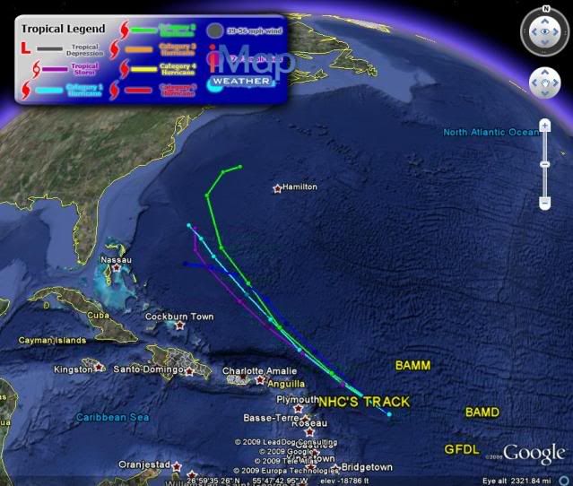
ATL: TROPICAL DEPRESSION DANNY (05L)

Moderator: S2k Moderators

Message
Author
User avatar
HURAKAN
Professional-Met
Professional-Met
Posts: 46086
Age: 37
Joined: Thu May 20, 2004 4:34 pm
Location: Key West, FL
Contact:

ATL: TROPICAL DEPRESSION DANNY (05L)

#1 Postby HURAKAN » Mon Aug 24, 2009 8:09 am

BEGIN
NHC_ATCF
invest_al922009.invest
FSTDA
R
U
040
010
0000
200908241325
NONE
NOTIFY=ATRP
END
INVEST, AL, L, , , , , 92, 2009, DB, O, 2009082412, 9999999999, , , , , , METWATCH, , AL922009
AL, 92, 2009082312, , BEST, 0, 140N, 480W, 20, 1011, DB, 0, , 0, 0, 0, 0,
AL, 92, 2009082318, , BEST, 0, 146N, 500W, 20, 1011, DB, 0, , 0, 0, 0, 0,
AL, 92, 2009082400, , BEST, 0, 152N, 520W, 20, 1011, DB, 0, , 0, 0, 0, 0,
AL, 92, 2009082406, , BEST, 0, 159N, 540W, 20, 1010, DB, 34, NEQ, 0, 0, 0, 0, 850, 0, 0, 0, 0,
AL, 92, 2009082412, , BEST, 0, 165N, 560W, 20, 1010, DB, 34, NEQ, 0, 0, 0, 0, 1012, 200, 0, 0, 0, L, 0, , 0, 0, INVEST, M,


Image
0 likes   

User avatar
HURAKAN
Professional-Met
Professional-Met
Posts: 46086
Age: 37
Joined: Thu May 20, 2004 4:34 pm
Location: Key West, FL
Contact:

ATL: TROPICAL DEPRESSION DANNY - Computer Models

#2 Postby HURAKAN » Mon Aug 24, 2009 8:12 am

647
WHXX01 KWBC 241327
CHGHUR
TROPICAL CYCLONE GUIDANCE MESSAGE
NWS TPC/NATIONAL HURRICANE CENTER MIAMI FL
1327 UTC MON AUG 24 2009

DISCLAIMER...NUMERICAL MODELS ARE SUBJECT TO LARGE ERRORS.
PLEASE REFER TO NHC OFFICIAL FORECASTS FOR TROPICAL CYCLONE
AND SUBTROPICAL CYCLONE INFORMATION.

ATLANTIC OBJECTIVE AIDS FOR

DISTURBANCE INVEST (AL922009) 20090824 1200 UTC

...00 HRS... ...12 HRS... ...24 HRS. .. ...36 HRS...
090824 1200 090825 0000 090825 1200 090826 0000

LAT LON LAT LON LAT LON LAT LON
BAMS 16.5N 56.0W 19.0N 60.0W 21.8N 63.8W 24.7N 66.4W
BAMD 16.5N 56.0W 18.4N 58.7W 20.3N 61.2W 22.1N 63.3W
BAMM 16.5N 56.0W 18.4N 59.3W 20.4N 62.3W 22.3N 64.5W
LBAR 16.5N 56.0W 18.3N 59.2W 20.2N 62.1W 21.8N 64.7W
SHIP 20KTS 24KTS 30KTS 36KTS
DSHP 20KTS 24KTS 30KTS 36KTS

...48 HRS... ...72 HRS... ...96 HRS. .. ..120 HRS...
090826 1200 090827 1200 090828 1200 090829 1200

LAT LON LAT LON LAT LON LAT LON
BAMS 27.2N 68.9W 31.4N 71.0W 33.6N 70.0W 34.2N 68.5W
BAMD 23.6N 64.9W 25.2N 67.5W 25.7N 69.5W 25.8N 71.6W
BAMM 23.9N 66.4W 26.5N 69.4W 27.8N 70.7W 28.8N 72.0W
LBAR 23.4N 66.9W 25.7N 69.8W 26.9N 71.0W 28.6N 71.4W
SHIP 43KTS 52KTS 61KTS 72KTS
DSHP 43KTS 52KTS 61KTS 72KTS

...INITIAL CONDITIONS...
LATCUR = 16.5N LONCUR = 56.0W DIRCUR = 290DEG SPDCUR = 20KT
LATM12 = 15.2N LONM12 = 52.0W DIRM12 = 289DEG SPDM12 = 20KT
LATM24 = 14.0N LONM24 = 48.0W
WNDCUR = 20KT RMAXWD = 0NM WNDM12 = 20KT
CENPRS = 1010MB OUTPRS = 1012MB OUTRAD = 200NM SDEPTH = M
RD34NE = 0NM RD34SE = 0NM RD34SW = 0NM RD34NW = 0NM

$$
NNNN
0 likes   

User avatar
Blown Away
S2K Supporter
S2K Supporter
Posts: 9863
Joined: Wed May 26, 2004 6:17 am

Re: ATL: Invest 92L

#3 Postby Blown Away » Mon Aug 24, 2009 8:22 am

The models seem to bring 92L near SFL then up the EC. That trough is going to be sitting on SFL for a few days and if this wave moves at the 20-25mph clip I don't see it making it to SFL before recurving.
0 likes   

User avatar
KWT
Category 5
Category 5
Posts: 31390
Joined: Tue Aug 17, 2004 11:02 am
Location: UK!!!

#4 Postby KWT » Mon Aug 24, 2009 8:26 am

The thing is the steering currents look pretty slack past 48hrs as the upper trough moves out of the way. Not the easiest one to call to be honest but we've seen these sorts of systems pull off big shocks in the past before so worth watching. Pattern post 96hrs may well favour an east coast rider if it sets up far enough to the SW.
0 likes   

canes04
Category 1
Category 1
Posts: 296
Joined: Sat May 22, 2004 5:41 pm
Location: Miami, FL

Re: ATL: Invest 92L

#5 Postby canes04 » Mon Aug 24, 2009 8:33 am

Per 8am discussion, appears to be slowing down. This could be an interesting week.

AN ATLANTIC OCEAN TROPICAL WAVE IS ALONG 55W/56W TO THE SOUTH OF
23N...NOT MOVING MUCH DURING THE LAST SIX HOURS. IT HAD BEEN
MOVING WEST ABOUT 20 KT. SCATTERED MODERATE SHOWERS TO ISOLATED
STRONG THUNDERSTORMS FROM 14N TO 20N BETWEEN 50W AND 60W.
0 likes   

User avatar
AdamFirst
S2K Supporter
S2K Supporter
Posts: 2487
Age: 35
Joined: Thu Aug 14, 2008 10:54 am
Location: Port Saint Lucie, FL

#6 Postby AdamFirst » Mon Aug 24, 2009 8:34 am

12Z NOGAPS has a formidable cyclone (high-end tropical storm, it looks like), brushing Hatteras in 5 days

Image
0 likes   

User avatar
srainhoutx
S2K Supporter
S2K Supporter
Posts: 6919
Age: 66
Joined: Sun Jan 14, 2007 11:34 am
Location: Haywood County, NC
Contact:

Re: ATL: Invest 92L

#7 Postby srainhoutx » Mon Aug 24, 2009 8:37 am

I'll agree that the next 48 hours look rather unimpressive for 92L, but just beyond that time frame all bets are off. Again the interesting part of this disturbance is the persisant guidance and the bullish nature of the HPC on developing this near the Bahamas. We all remember what happened 4 years ago with a weak, sickly looking disturabance, so worth watching IMHO.
0 likes   

User avatar
HURAKAN
Professional-Met
Professional-Met
Posts: 46086
Age: 37
Joined: Thu May 20, 2004 4:34 pm
Location: Key West, FL
Contact:

#8 Postby HURAKAN » Mon Aug 24, 2009 8:41 am

Image

First track forecast
0 likes   

User avatar
HURAKAN
Professional-Met
Professional-Met
Posts: 46086
Age: 37
Joined: Thu May 20, 2004 4:34 pm
Location: Key West, FL
Contact:

Re: ATL: Invest 92L - Computer Models

#9 Postby HURAKAN » Mon Aug 24, 2009 8:44 am

Code: Select all

                    *   ATLANTIC SHIPS INTENSITY FORECAST       *
                    *      GOES DATA AVAILABLE                  *
                    *      OHC  DATA AVAILABLE                  *
                    *  INVEST      AL922009  08/24/09  12 UTC   *

TIME (HR)          0     6    12    18    24    36    48    60    72    84    96   108   120
SHEAR (KT)        26    22    20    17    16     7    13    14    20    10    12     2     0
SHEAR DIR        257   276   269   273   281   250   328   356   356   352   347   286   203
SST (C)         28.1  28.2  28.3  28.4  28.4  28.6  28.7  28.9  29.0  29.0  29.0  28.9  28.9


Shear decreases, then increases, and then decreases.
0 likes   

StormClouds63
Category 2
Category 2
Posts: 583
Age: 60
Joined: Tue May 13, 2008 11:56 am
Location: Southwest Louisiana

Re: ATL: Invest 92L

#10 Postby StormClouds63 » Mon Aug 24, 2009 8:48 am

Another re-curve scenario ... Pattern like 2006 now seems more plausible?
0 likes   

User avatar
KWT
Category 5
Category 5
Posts: 31390
Joined: Tue Aug 17, 2004 11:02 am
Location: UK!!!

#11 Postby KWT » Mon Aug 24, 2009 8:49 am

Yeah I think the steering currents are meant to weaken once this gets closer to the Bahamas region.

srainhoutx, totally agree this does need very close watching, whilst its quite possible it will recurve sharply enough to avoid landfall this is a somewhat different set-up then with Bill as this system should end up somewhat further south-west. Also history does show us that these systems can become quite strong, hurricane status is possible IMO.

stormcloud, this may not be a recurve, indeed even if it does recurve it maybe far enough south-west to still hit the Outer Banks.
0 likes   

User avatar
KWT
Category 5
Category 5
Posts: 31390
Joined: Tue Aug 17, 2004 11:02 am
Location: UK!!!

#12 Postby KWT » Mon Aug 24, 2009 8:53 am

Thats of course on the assumption it carries on heading NW like those models are suggesting, I suspect we will see the system end up a good 5 degrees further west by the end of those runs when we get to the time.
0 likes   

Frank2
Category 5
Category 5
Posts: 4061
Joined: Mon Jul 25, 2005 12:47 pm

Re: ATL: Invest 92L

#13 Postby Frank2 » Mon Aug 24, 2009 8:53 am

It doesn't look like anything more than a disorganized wave interacting with the opening ULL, so I'll stick with my guess of nothing to track until at least next week, since there's nothing else behind 92L ATTM...

Frank
0 likes   

User avatar
KWT
Category 5
Category 5
Posts: 31390
Joined: Tue Aug 17, 2004 11:02 am
Location: UK!!!

#14 Postby KWT » Mon Aug 24, 2009 8:59 am

Yeah thats what it is right now but models prog that to change. Funnily enough GFS is the least bullish of all the models which is rather odd but its constantly forming a low to the NE where this system is progged to be by all the other models.

For now its not much but conditions are exepected to improve downstream, esp when this system gets into weaker steering currents, we shall see though, GFS may end up being right who knows!
0 likes   

User avatar
HURAKAN
Professional-Met
Professional-Met
Posts: 46086
Age: 37
Joined: Thu May 20, 2004 4:34 pm
Location: Key West, FL
Contact:

#15 Postby HURAKAN » Mon Aug 24, 2009 9:03 am

Image

Another area to watch is the trough off the SE coast. Continues to flare and you know that where there's smoke, there's fire!
0 likes   

User avatar
KWT
Category 5
Category 5
Posts: 31390
Joined: Tue Aug 17, 2004 11:02 am
Location: UK!!!

#16 Postby KWT » Mon Aug 24, 2009 9:06 am

Possibly Hurakan, one thing that will be interesting to observe is how much of an impact if any the trough will have on this whole set-up. The GFS shows this trough hanging about for a few days as well so it may make a difference, who knows!
0 likes   

User avatar
gatorcane
S2K Supporter
S2K Supporter
Posts: 23499
Age: 46
Joined: Sun Mar 13, 2005 3:54 pm
Location: Boca Raton, FL

#17 Postby gatorcane » Mon Aug 24, 2009 9:13 am

Not all models recurve, 12Z deep bams bend it back west, wonder what it is seeing

Image
0 likes   

OuterBanker
S2K Supporter
S2K Supporter
Posts: 1704
Joined: Wed Feb 26, 2003 10:53 am
Location: Nags Head, NC
Contact:

#18 Postby OuterBanker » Mon Aug 24, 2009 9:22 am

Sure enough, GFS doesn't see it al all. But European, Canadian, UKMET all see it. The CMC is the strongest, but they develop about 100 hurricanes a year anyway. I don't think this will develop until 70 west anyway. This year will be clear for anything below 20 N also I think. Strangely enough, the EPAC is the same way.

BTW, we were out of town this weekend and we were afraid that our nephew would go surfing Saturday. He went, but though better of it and didn't hit the water. But he surfed what turned out to be perfect surf all day Sunday. Perfect 6 and 8 ft tubes and clean.
0 likes   

Sanibel
Category 5
Category 5
Posts: 10348
Joined: Mon Aug 30, 2004 11:06 pm
Location: Offshore SW Florida

Re: ATL: Invest 92L

#19 Postby Sanibel » Mon Aug 24, 2009 9:33 am

The "perma-trough" is back over us with a SW flow and lack of rain. This synoptic has established a steering pattern up the East Coast that can be seen in the visible satellite.

Good thing the pattern is ocean-ward this year because this kind of entry position for a developing wave is a nightmare track in a more westward steering pattern at this time of year. Think Andrew, Labor Day Storm, and Katrina for examples. Thank goodness the steering pattern is NOT towards Florida.

What will the ULL do?
Last edited by Sanibel on Mon Aug 24, 2009 9:34 am, edited 1 time in total.
0 likes   

User avatar
Stormsfury
Category 5
Category 5
Posts: 10549
Age: 51
Joined: Wed Feb 05, 2003 6:27 pm
Location: Summerville, SC

#20 Postby Stormsfury » Mon Aug 24, 2009 9:34 am

The projected large scale pattern in the next 5 to 7 days by the global models strongly resembles that to what occurred in 1991 with Hurricane Bob.
0 likes   


Return to “2009”

Who is online

Users browsing this forum: No registered users and 64 guests