ATL: TROPICAL DEPRESSION DANNY (05L)
Moderator: S2k Moderators
-
MGC

- S2K Supporter

- Posts: 5792
- Joined: Sun Mar 23, 2003 9:05 pm
- Location: Pass Christian MS, or what is left.
Re: ATL: TROPICAL STORM DANNY
Looks like naked Danny is scooting a bit NNE. Circulation looks to be elongating somewhat. I don't think Danny has long.....he is going to die of exposure......MGC
0 likes
-
massweathernet

- Tropical Low

- Posts: 48
- Joined: Mon May 18, 2009 1:52 pm
- Location: Boston, MA
- Contact:
Re: ATL: TROPICAL STORM DANNY
Last edited by massweathernet on Fri Aug 28, 2009 3:48 pm, edited 1 time in total.
0 likes
-
HURAKAN

- Professional-Met

- Posts: 46086
- Age: 37
- Joined: Thu May 20, 2004 4:34 pm
- Location: Key West, FL
- Contact:
070
URNT15 KNHC 282040
AF302 0805A DANNY HDOB 30 20090828
203030 3022N 07525W 9594 00419 0061 +240 +230 344004 005 007 001 00
203100 3020N 07526W 9597 00417 0062 +241 +230 331006 007 008 002 03
203130 3019N 07527W 9589 00425 0062 +242 +230 326009 009 999 999 03
203200 3020N 07529W 9593 00420 0062 +241 +231 328008 009 001 003 03
203230 3021N 07529W 9590 00423 0063 +239 +232 349008 009 003 003 03
203300 3022N 07531W 9593 00421 0063 +240 +232 004010 010 009 002 00
203330 3023N 07532W 9593 00422 0063 +240 +231 003009 009 005 003 00
203400 3024N 07533W 9594 00422 0064 +240 +230 010008 009 007 001 00
203430 3026N 07534W 9594 00422 0066 +240 +229 010007 007 009 001 00
203500 3027N 07535W 9593 00425 0067 +240 +228 014006 006 006 002 00
203530 3028N 07537W 9596 00423 0068 +240 +228 020006 006 007 002 00
203600 3029N 07538W 9594 00425 0068 +240 +227 025006 007 009 001 00
203630 3030N 07539W 9594 00425 0069 +240 +227 027009 010 006 002 00
203700 3031N 07540W 9594 00426 0070 +240 +226 027010 010 006 002 00
203730 3032N 07541W 9594 00428 0071 +240 +226 040009 009 005 002 00
203800 3034N 07543W 9594 00428 0072 +240 +225 040008 008 006 002 00
203830 3035N 07544W 9594 00428 0072 +238 +225 048008 008 008 002 00
203900 3036N 07545W 9594 00428 0072 +240 +225 054008 009 007 002 00
203930 3037N 07546W 9594 00428 0072 +240 +225 055008 008 019 000 03
204000 3038N 07547W 9594 00430 0074 +238 +225 053009 009 019 000 03
$$
;
0 likes
-
Lowpressure

- S2K Supporter
- Posts: 2032
- Age: 57
- Joined: Sun Sep 14, 2003 9:17 am
- Location: Charlotte, North Carolina
-
HURAKAN
- Professional-Met
- Posts: 46086
- Age: 37
- Joined: Thu May 20, 2004 4:34 pm
- Location: Key West, FL
- Contact:
Re: ATL: TROPICAL STORM DANNY
massweathernet wrote:http://www.ssd.noaa.gov/goes/flt/t1/flash-vis-s.html
New pop up thunderstorm SW of the LLC.
Thunderstorms are developing on the SE quadrant
0 likes
-
massweathernet
- Tropical Low
- Posts: 48
- Joined: Mon May 18, 2009 1:52 pm
- Location: Boston, MA
- Contact:
Re: ATL: TROPICAL STORM DANNY
HURAKAN wrote:massweathernet wrote:http://www.ssd.noaa.gov/goes/flt/t1/flash-vis-s.html
New pop up thunderstorm SW of the LLC.
Thunderstorms are developing on the SE quadrant
My bad. I meant SE but I typed SW.
0 likes
-
HURAKAN
- Professional-Met
- Posts: 46086
- Age: 37
- Joined: Thu May 20, 2004 4:34 pm
- Location: Key West, FL
- Contact:
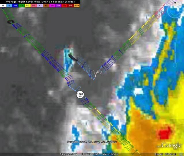
331
URNT12 KNHC 282046
VORTEX DATA MESSAGE AL052009
A. 28/20:29:40Z
B. 30 deg 24 min N
075 deg 24 min W
C. NA
D. 29 kt
E. 050 deg 147 nm
F. 141 deg 35 kt
G. 050 deg 121 nm
H. EXTRAP 1006 mb
I. 23 C / 459 m
J. 24 C / 457 m
K. 23 C / NA
L. NA
M. NA
N. 1345 / 01
O. 0.02 / 1 nm
P. AF302 0805A DANNY OB 08
MAX FL WIND 40 KT NE QUAD 19:26:50Z
SLP EXTRAP FROM BELOW 1500 FT
;
0 likes
-
UpTheCreek

- Category 1

- Posts: 397
- Age: 60
- Joined: Tue Aug 31, 2004 5:28 pm
- Location: Vassalboro, Maine
Re:
Lowpressure wrote:I think those that think this will get better organized should back up and realize this is a pathetic excuse for a TS. If it even is a TS. The rain bands on the coast are from the ULL moving up the interior. Next.
Not here in New Bern, the rain on my rooftop is from Danny.....at least for the time being.
0 likes
-
HURAKAN
- Professional-Met
- Posts: 46086
- Age: 37
- Joined: Thu May 20, 2004 4:34 pm
- Location: Key West, FL
- Contact:
706
URNT15 KNHC 282050
AF302 0805A DANNY HDOB 31 20090828
204030 3039N 07549W 9593 00431 0074 +237 +225 054008 009 999 999 03
204100 3040N 07550W 9594 00431 0076 +235 +225 052007 007 999 999 03
204130 3040N 07550W 9594 00431 0077 +235 +225 054007 007 018 000 03
204200 3043N 07552W 9593 00433 0076 +239 +225 061006 006 999 999 03
204230 3044N 07553W 9593 00433 0077 +239 +225 065006 006 016 000 03
204300 3045N 07555W 9596 00431 0077 +240 +225 063006 006 999 999 03
204330 3046N 07556W 9594 00432 0077 +240 +225 055005 005 018 000 03
204400 3047N 07557W 9594 00433 0077 +240 +224 063005 005 018 000 03
204430 3049N 07558W 9594 00432 0078 +239 +225 066006 007 019 000 03
204500 3050N 07600W 9593 00433 0078 +235 +224 065007 007 999 999 03
204530 3051N 07601W 9593 00434 0078 +235 +224 070006 007 018 000 03
204600 3052N 07602W 9594 00433 0079 +235 +224 070006 007 017 000 03
204630 3053N 07603W 9593 00435 0079 +236 +223 073005 005 999 999 03
204700 3054N 07604W 9593 00434 0079 +235 +223 071005 005 017 000 03
204730 3055N 07606W 9593 00436 0080 +235 +222 070004 005 015 000 03
204800 3057N 07607W 9596 00434 0080 +240 +222 057004 004 017 000 03
204830 3058N 07608W 9593 00435 0080 +240 +221 055004 004 018 000 03
204900 3059N 07609W 9593 00436 0080 +240 +222 050004 004 999 999 03
204930 3100N 07611W 9594 00435 0080 +240 +222 065004 005 999 999 03
205000 3101N 07612W 9593 00437 0081 +240 +222 068005 005 017 000 03
$$
;
0 likes
-
massweathernet
- Tropical Low
- Posts: 48
- Joined: Mon May 18, 2009 1:52 pm
- Location: Boston, MA
- Contact:


Re: ATL: TROPICAL STORM DANNY
Danny is about to be blasted apart by the ULL heading for it....I give it another 18hrs if that.
WXMN57 time to call it with your signature picture....
WXMN57 time to call it with your signature picture....
0 likes
-
HURAKAN
- Professional-Met
- Posts: 46086
- Age: 37
- Joined: Thu May 20, 2004 4:34 pm
- Location: Key West, FL
- Contact:
533
URNT15 KNHC 282100
AF302 0805A DANNY HDOB 32 20090828
205030 3102N 07613W 9593 00437 0082 +240 +221 056005 005 015 000 03
205100 3104N 07614W 9594 00436 0082 +240 +221 058006 007 007 002 00
205130 3105N 07615W 9594 00437 0082 +240 +221 058007 007 012 000 00
205200 3106N 07617W 9594 00438 0082 +240 +221 053006 006 009 001 00
205230 3107N 07618W 9594 00437 0082 +241 +221 051006 007 008 001 00
205300 3108N 07619W 9593 00437 0082 +243 +221 050008 008 009 001 00
205330 3109N 07620W 9594 00437 0082 +240 +222 054008 008 008 002 00
205400 3110N 07622W 9581 00442 0076 +240 +222 058010 010 011 000 00
205430 3112N 07623W 9586 00446 0081 +236 +222 062010 011 010 000 00
205500 3113N 07625W 9592 00440 0085 +234 +224 058010 011 010 001 00
205530 3115N 07626W 9589 00442 0084 +231 +226 061010 010 009 001 00
205600 3117N 07628W 9597 00435 0084 +232 +228 064009 010 010 001 00
205630 3118N 07630W 9595 00437 0084 +230 +230 064009 009 011 001 00
205700 3120N 07632W 9591 00440 0084 +230 +230 067009 010 007 002 00
205730 3122N 07634W 9599 00433 0084 +230 +230 067010 011 009 001 00
205800 3123N 07635W 9590 00442 0084 +234 +234 073010 011 010 001 00
205830 3125N 07637W 9597 00436 0084 +233 +233 071011 012 011 001 00
205900 3127N 07639W 9597 00436 0086 +230 +230 071012 013 014 000 00
205930 3128N 07641W 9590 00444 0086 +230 +230 073012 012 010 002 00
210000 3130N 07643W 9599 00436 0087 +230 +230 075011 012 017 000 00
$$
;
0 likes
-
vbhoutex

- Storm2k Executive

- Posts: 28974
- Age: 72
- Joined: Wed Oct 09, 2002 11:31 pm
- Location: Spring Branch area, Houston, TX
- Contact:
Re: ATL: TROPICAL STORM DANNY
massweathernet wrote:Bands can clearly be seen on KLTX's NEXRAD in 248 NMI Mode:
As was stated above I believe those bands over land seem to be more a product of the ULL moving into that area than Danny. Probably a combination of the two air masses colliding and squeezing the moisture out to put it very simply. There is no substantial convection directly as the result of Danny to the west of his LLCC that I can see.
0 likes
-
massweathernet
- Tropical Low
- Posts: 48
- Joined: Mon May 18, 2009 1:52 pm
- Location: Boston, MA
- Contact:
Re: ATL: TROPICAL STORM DANNY
vbhoutex wrote:massweathernet wrote:Bands can clearly be seen on KLTX's NEXRAD in 248 NMI Mode:
As was stated above I believe those bands over land seem to be more a product of the ULL moving into that area than Danny. Probably a combination of the two air masses colliding and squeezing the moisture out to put it very simply. There is no substantial convection directly as the result of Danny to the west of his LLCC that I can see.
If you observe the radar image carefully, you can clearly see the differences in direction, from both systems. Danny's rain is coming from the east onshore and the ULL's is coming from the south.
0 likes
-
HURAKAN
- Professional-Met
- Posts: 46086
- Age: 37
- Joined: Thu May 20, 2004 4:34 pm
- Location: Key West, FL
- Contact:
346
URNT15 KNHC 282110
AF302 0805A DANNY HDOB 33 20090828
210030 3132N 07645W 9590 00444 0087 +230 +230 074011 011 016 000 00
210100 3133N 07646W 9594 00440 0087 +231 +231 076011 012 016 000 00
210130 3135N 07648W 9597 00438 0088 +230 +230 074011 011 016 000 00
210200 3137N 07650W 9589 00445 0088 +230 +230 076010 011 010 002 00
210230 3139N 07652W 9596 00439 0086 +230 +230 078010 011 012 001 00
210300 3140N 07654W 9320 00692 0083 +218 +218 084008 008 012 001 05
210330 3142N 07655W 8523 01493 9990 +185 +999 081005 007 999 999 05
210400 3143N 07657W 8132 01898 9990 +163 +999 086002 003 999 999 05
210430 3144N 07658W 7793 02262 9990 +146 +999 088002 005 999 999 05
210500 3145N 07700W 7476 02594 9990 +139 +999 141004 006 999 999 05
210530 3146N 07701W 7202 02908 9990 +127 +999 148006 007 999 999 05
210600 3147N 07703W 6980 03177 9990 +109 +999 161006 007 008 002 05
210630 3148N 07705W 6952 03205 9990 +105 +999 151006 007 011 000 01
210700 3150N 07707W 6963 03190 9990 +104 +999 150007 007 014 000 01
210730 3151N 07710W 6965 03184 9990 +105 +999 141007 007 009 001 01
210800 3153N 07713W 6969 03181 9990 +105 +999 132006 007 018 000 01
210830 3154N 07715W 6965 03185 9990 +104 +999 115007 007 016 001 01
210900 3156N 07718W 6970 03183 9990 +105 +999 128007 008 017 000 01
210930 3157N 07720W 6965 03187 9990 +105 +999 110010 011 999 999 05
211000 3159N 07723W 6967 03187 9990 +105 +999 137007 008 999 999 05
$$
;
Ascending and leaving
0 likes
-
NC George

- Category 2

- Posts: 624
- Age: 54
- Joined: Sun Sep 14, 2003 11:44 am
- Location: Washington, NC, USA
Re: ATL: TROPICAL STORM DANNY
vbhoutex wrote:massweathernet wrote:Bands can clearly be seen on KLTX's NEXRAD in 248 NMI Mode:
As was stated above I believe those bands over land seem to be more a product of the ULL moving into that area than Danny. Probably a combination of the two air masses colliding and squeezing the moisture out to put it very simply. There is no substantial convection directly as the result of Danny to the west of his LLCC that I can see.
I agree that the bands are a combination of the ULL and Danny, but the one primarily associated with the ULL are going from the SE to the NW, and moving northward, while the ones primarily associated with Danny are going from the NE to the SW, and moving westwards. It's easier to see on a longer loop of the GA/SC/NC area.
0 likes
Who is online
Users browsing this forum: No registered users and 122 guests