ATL: TROPICAL DEPRESSION HENRI (10L)
Moderator: S2k Moderators
-
wxman57

- Moderator-Pro Met

- Posts: 22482
- Age: 66
- Joined: Sat Jun 21, 2003 8:06 pm
- Location: Houston, TX (southwest)
Re: ATL: TROPICAL STORM HENRI (10L)
The center is moving directly into the core of highest shear now. Doesn't matter if it's moving west, WNW or WSW (or even NW or SW). Shear is increasing and it's being torn apart more by the minute.
0 likes
-
Derek Ortt
Re: ATL: TROPICAL STORM HENRI (10L)
Cuber wrote:Derek Ortt wrote:wxman57 wrote:KF CP = Kentucky Fried Chicken People? That's just what popped into my head first. Must be lunch time.
LOL
ProMets laughing out loud and admitting to thinking about lunch during tropical storm/cyclone season ??? more evidence of a hum-drum 2009 (but keep your waders and slicker nearby Gusty ... just in case)
KF CP is actually a met term
0 likes
-
Gustywind

- Category 5

- Posts: 12334
- Joined: Mon Sep 03, 2007 7:29 am
- Location: Baie-Mahault, GUADELOUPE
Re: ATL: TROPICAL STORM HENRI (10L)
Cuber wrote:Derek Ortt wrote:wxman57 wrote:KF CP = Kentucky Fried Chicken People? That's just what popped into my head first. Must be lunch time.
LOL
ProMets laughing out loud and admitting to thinking about lunch during tropical storm/cyclone season ??? more evidence of a hum-drum 2009 (but keep your waders and slicker nearby Gusty ... just in case)
Tkanks Cuber
0 likes
-
Evil Jeremy

- S2K Supporter

- Posts: 5459
- Age: 30
- Joined: Mon Apr 10, 2006 2:10 pm
- Location: Los Angeles, CA
Re: ATL: TROPICAL STORM HENRI (10L)
Small but intense burst of convection on the NE part of the circulation:
http://www.ssd.noaa.gov/goes/flt/t1/wv-l.jpg
http://www.ssd.noaa.gov/goes/flt/t1/wv-l.jpg
0 likes
Frances 04 / Jeanne 04 / Katrina 05 / Wilma 05 / Fay 08 / Debby 12 / Andrea 13 / Colin 16 / Hermine 16 / Matthew 16 / Irma 17
Re: ATL: TROPICAL STORM HENRI (10L)
Derek Ortt wrote:Cuber wrote:wxman57 wrote:KF CP = Kentucky Fried Chicken People? That's just what popped into my head first. Must be lunch time.
ProMets laughing out loud and admitting to thinking about lunch during tropical storm/cyclone season ??? more evidence of a hum-drum 2009 (but keep your waders and slicker nearby Gusty ... just in case)
KF CP is actually a met term
From google, KF CP = Kain-Fritsch (KF) clouds parameterization (CP)
0 likes
-
Evil Jeremy
- S2K Supporter
- Posts: 5459
- Age: 30
- Joined: Mon Apr 10, 2006 2:10 pm
- Location: Los Angeles, CA
Re: ATL: TROPICAL STORM HENRI (10L)
Yea, the circulation is still there. A little ragged and hard to see, but it is there. I think the new convection on the NE part of the center might buy Henri 6 more hours of life.
Hmm, looking at the circulation, it looks like Henri is slowing down over the past couple of hours.
Hmm, looking at the circulation, it looks like Henri is slowing down over the past couple of hours.
0 likes
Frances 04 / Jeanne 04 / Katrina 05 / Wilma 05 / Fay 08 / Debby 12 / Andrea 13 / Colin 16 / Hermine 16 / Matthew 16 / Irma 17

-
Derek Ortt
-
Evil Jeremy
- S2K Supporter
- Posts: 5459
- Age: 30
- Joined: Mon Apr 10, 2006 2:10 pm
- Location: Los Angeles, CA

Re:
Derek Ortt wrote:circu still present on nighttime visible
In fact, the convection has moved closer to the center in the last 2 hours, which means the shear may be starting to relax. Still very exposed though
12z nogaps and cmc and 18z hwrf now hold on to Henri through 96hrs so you might be right about the shear letting up.
http://moe.met.fsu.edu/tcgengifs/
0 likes

Re: ATL: TROPICAL STORM HENRI (10L)
Any chance that the remnants making it as far west as Florida?
0 likes

Re: ATL: TROPICAL STORM HENRI (10L)
boca wrote:Any chance that the remnants making it as far west as Florida?
18Z HWRF shows the remnants very close to Florida's coast:
120 hours HWRF
0 likes

786
WHXX01 KWBC 080039
CHGHUR
TROPICAL CYCLONE GUIDANCE MESSAGE
NWS TPC/NATIONAL HURRICANE CENTER MIAMI FL
0039 UTC THU OCT 8 2009
DISCLAIMER...NUMERICAL MODELS ARE SUBJECT TO LARGE ERRORS.
PLEASE REFER TO NHC OFFICIAL FORECASTS FOR TROPICAL CYCLONE
AND SUBTROPICAL CYCLONE INFORMATION.
ATLANTIC OBJECTIVE AIDS FOR
TROPICAL CYCLONE HENRI (AL102009) 20091008 0000 UTC
...00 HRS... ...12 HRS... ...24 HRS. .. ...36 HRS...
091008 0000 091008 1200 091009 0000 091009 1200
LAT LON LAT LON LAT LON LAT LON
BAMS 19.3N 59.2W 20.1N 61.4W 20.7N 63.0W 20.8N 64.9W
BAMD 19.3N 59.2W 20.3N 60.9W 20.8N 62.3W 20.5N 64.2W
BAMM 19.3N 59.2W 20.1N 61.1W 20.6N 62.6W 20.4N 64.6W
LBAR 19.3N 59.2W 20.6N 61.1W 21.7N 62.2W 22.0N 62.7W
SHIP 35KTS 30KTS 29KTS 32KTS
DSHP 35KTS 30KTS 29KTS 32KTS
...48 HRS... ...72 HRS... ...96 HRS. .. ..120 HRS...
091010 0000 091011 0000 091012 0000 091013 0000
LAT LON LAT LON LAT LON LAT LON
BAMS 20.9N 67.1W 21.4N 72.0W 22.4N 77.0W 23.0N 80.8W
BAMD 20.3N 66.8W 20.8N 73.0W 22.0N 77.9W 22.5N 81.4W
BAMM 20.3N 67.3W 21.1N 73.3W 22.4N 78.2W 23.0N 81.5W
LBAR 21.5N 63.4W 20.5N 66.0W 20.3N 71.7W 20.1N 77.3W
SHIP 38KTS 49KTS 61KTS 71KTS
DSHP 38KTS 49KTS 61KTS 71KTS
...INITIAL CONDITIONS...
LATCUR = 19.3N LONCUR = 59.2W DIRCUR = 285DEG SPDCUR = 13KT
LATM12 = 18.6N LONM12 = 56.6W DIRM12 = 296DEG SPDM12 = 12KT
LATM24 = 17.9N LONM24 = 54.6W
WNDCUR = 35KT RMAXWD = 30NM WNDM12 = 45KT
CENPRS = 1008MB OUTPRS = 1012MB OUTRAD = 100NM SDEPTH = M
RD34NE = 60NM RD34SE = 90NM RD34SW = 0NM RD34NW = 0NM
0 likes
-
HURAKAN

- Professional-Met

- Posts: 46086
- Age: 37
- Joined: Thu May 20, 2004 4:34 pm
- Location: Key West, FL
- Contact:
181
WTNT35 KNHC 080231
TCPAT5
BULLETIN
TROPICAL DEPRESSION HENRI ADVISORY NUMBER 6
NWS TPC/NATIONAL HURRICANE CENTER MIAMI FL AL102009
1100 PM AST WED OCT 07 2009
...HENRI WEAKENS TO A TROPICAL DEPRESSION...
AT 1100 PM AST...0300 UTC...THE CENTER OF TROPICAL DEPRESSION HENRI
WAS LOCATED NEAR LATITUDE 19.5 NORTH...LONGITUDE 59.7 WEST OR ABOUT
240 MILES...385 KM...EAST-NORTHEAST OF THE NORTHERN LEEWARD ISLANDS.
THE DEPRESSION IS MOVING TOWARD THE WEST-NORTHWEST NEAR 15 MPH. A
TURN TOWARD THE WEST WITH A DECREASE IN FORWARD SPEED IS EXPECTED
OVER THE NEXT DAY OR SO.
MAXIMUM SUSTAINED WINDS ARE NEAR 35 MPH...55 KM/HR...WITH HIGHER
GUSTS. ADDITIONAL WEAKENING IS FORECAST AND HENRI COULD DEGENERATE
INTO A REMNANT LOW ON THURSDAY.
ESTIMATED MINIMUM CENTRAL PRESSURE IS 1009 MB...29.80 INCHES.
...SUMMARY OF 1100 PM AST INFORMATION...
LOCATION...19.5N 59.7W
MAXIMUM SUSTAINED WINDS...35 MPH
PRESENT MOVEMENT...WEST-NORTHWEST OR 285 DEGREES AT 15 MPH
MINIMUM CENTRAL PRESSURE...1009 MB
THE NEXT ADVISORY WILL BE ISSUED BY THE NATIONAL HURRICANE CENTER AT
500 AM AST.
$$
FORECASTER CANGIALOSI/BEVEN
720
WTNT45 KNHC 080233
TCDAT5
TROPICAL DEPRESSION HENRI DISCUSSION NUMBER 6
NWS TPC/NATIONAL HURRICANE CENTER MIAMI FL AL102009
1100 PM AST WED OCT 07 2009
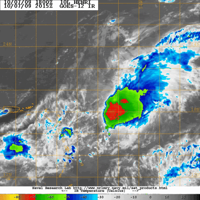
SATELLITE IMAGES AND MICROWAVE DATA INDICATE THAT THE LOW-LEVEL
CENTER OF HENRI IS LOCATED WELL TO THE WEST OF A PERSISTENT AREA OF
OF DEEP CONVECTION. THIS ASYMMETRIC STRUCTURE IS DUE TO ABOUT
25 KT OF SOUTHWESTERLY VERTICAL WIND SHEAR. DVORAK INTENSITY
ESTIMATES HAVE DECREASED AND ON THIS BASIS...HENRI IS BEING
DOWNGRADED TO A TROPICAL DEPRESSION WITH THE INITIAL INTENSITY SET
AT 30 KT. THE STRONG SOUTHWESTERLY SHEAR IS EXPECTED TO PERSIST
FOR ANOTHER 12 HOURS WHICH SHOULD CONTINUE TO DECOUPLE THE CYCLONE.
GLOBAL MODELS SHOW THAT HENRI...OR ITS REMNANTS...WILL BE MOVING
UNDER AN UPPER-LEVEL SHEAR AXIS BETWEEN 12 AND 36 HOURS.
THEREAFTER...STRONG NORTHEASTERLY MID- TO UPPER-LEVEL FLOW WILL
IMPACT THE SYSTEM. THIS UNFAVORABLE ATMOSPHERIC ENVIRONMENT SHOULD
LEAD TO CONTINUED WEAKENING AS UNANIMOUSLY SHOWN BY THE DYNAMICAL
MODELS. THE OFFICIAL FORECAST IS SIMILAR TO THE PREVIOUS ONE AND
CALLS FOR HENRI TO DEGENERATE INTO A REMNANT LOW WITHIN 24 HOURS.
THE INITIAL MOTION IS 285/13...SLIGHTLY TO THE SOUTH OF THE PREVIOUS
ADVISORY. THIS MOTION IS EXPECTED TO CONTINUE FOR ABOUT ANOTHER
DAY. THEREAFTER...A STRONG DEEP-LAYER RIDGE WILL BUILD OVER THE
WESTERN ATLANTIC CAUSING HENRI...OR ITS REMNANTS...TO TURN WESTWARD
OR SOUTHWESTWARD. THE NEW TRACK FORECAST IS NUDGED A LITTLE TO THE
SOUTH TO ACCOUNT FOR THE INITIAL HEADING AND IS NEAR THE BAM
SHALLOW.
FORECAST POSITIONS AND MAX WINDS
INITIAL 08/0300Z 19.5N 59.7W 30 KT
12HR VT 08/1200Z 20.1N 61.3W 30 KT
24HR VT 09/0000Z 20.7N 63.0W 25 KT...REMNANT LOW
36HR VT 09/1200Z 20.9N 65.0W 20 KT...REMNANT LOW
48HR VT 10/0000Z 20.6N 67.1W 20 KT...REMNANT LOW
72HR VT 11/0000Z...DISSIPATED
$$
FORECASTER CANGIALOSI/BEVEN
WTNT35 KNHC 080231
TCPAT5
BULLETIN
TROPICAL DEPRESSION HENRI ADVISORY NUMBER 6
NWS TPC/NATIONAL HURRICANE CENTER MIAMI FL AL102009
1100 PM AST WED OCT 07 2009
...HENRI WEAKENS TO A TROPICAL DEPRESSION...
AT 1100 PM AST...0300 UTC...THE CENTER OF TROPICAL DEPRESSION HENRI
WAS LOCATED NEAR LATITUDE 19.5 NORTH...LONGITUDE 59.7 WEST OR ABOUT
240 MILES...385 KM...EAST-NORTHEAST OF THE NORTHERN LEEWARD ISLANDS.
THE DEPRESSION IS MOVING TOWARD THE WEST-NORTHWEST NEAR 15 MPH. A
TURN TOWARD THE WEST WITH A DECREASE IN FORWARD SPEED IS EXPECTED
OVER THE NEXT DAY OR SO.
MAXIMUM SUSTAINED WINDS ARE NEAR 35 MPH...55 KM/HR...WITH HIGHER
GUSTS. ADDITIONAL WEAKENING IS FORECAST AND HENRI COULD DEGENERATE
INTO A REMNANT LOW ON THURSDAY.
ESTIMATED MINIMUM CENTRAL PRESSURE IS 1009 MB...29.80 INCHES.
...SUMMARY OF 1100 PM AST INFORMATION...
LOCATION...19.5N 59.7W
MAXIMUM SUSTAINED WINDS...35 MPH
PRESENT MOVEMENT...WEST-NORTHWEST OR 285 DEGREES AT 15 MPH
MINIMUM CENTRAL PRESSURE...1009 MB
THE NEXT ADVISORY WILL BE ISSUED BY THE NATIONAL HURRICANE CENTER AT
500 AM AST.
$$
FORECASTER CANGIALOSI/BEVEN
720
WTNT45 KNHC 080233
TCDAT5
TROPICAL DEPRESSION HENRI DISCUSSION NUMBER 6
NWS TPC/NATIONAL HURRICANE CENTER MIAMI FL AL102009
1100 PM AST WED OCT 07 2009
SATELLITE IMAGES AND MICROWAVE DATA INDICATE THAT THE LOW-LEVEL
CENTER OF HENRI IS LOCATED WELL TO THE WEST OF A PERSISTENT AREA OF
OF DEEP CONVECTION. THIS ASYMMETRIC STRUCTURE IS DUE TO ABOUT
25 KT OF SOUTHWESTERLY VERTICAL WIND SHEAR. DVORAK INTENSITY
ESTIMATES HAVE DECREASED AND ON THIS BASIS...HENRI IS BEING
DOWNGRADED TO A TROPICAL DEPRESSION WITH THE INITIAL INTENSITY SET
AT 30 KT. THE STRONG SOUTHWESTERLY SHEAR IS EXPECTED TO PERSIST
FOR ANOTHER 12 HOURS WHICH SHOULD CONTINUE TO DECOUPLE THE CYCLONE.
GLOBAL MODELS SHOW THAT HENRI...OR ITS REMNANTS...WILL BE MOVING
UNDER AN UPPER-LEVEL SHEAR AXIS BETWEEN 12 AND 36 HOURS.
THEREAFTER...STRONG NORTHEASTERLY MID- TO UPPER-LEVEL FLOW WILL
IMPACT THE SYSTEM. THIS UNFAVORABLE ATMOSPHERIC ENVIRONMENT SHOULD
LEAD TO CONTINUED WEAKENING AS UNANIMOUSLY SHOWN BY THE DYNAMICAL
MODELS. THE OFFICIAL FORECAST IS SIMILAR TO THE PREVIOUS ONE AND
CALLS FOR HENRI TO DEGENERATE INTO A REMNANT LOW WITHIN 24 HOURS.
THE INITIAL MOTION IS 285/13...SLIGHTLY TO THE SOUTH OF THE PREVIOUS
ADVISORY. THIS MOTION IS EXPECTED TO CONTINUE FOR ABOUT ANOTHER
DAY. THEREAFTER...A STRONG DEEP-LAYER RIDGE WILL BUILD OVER THE
WESTERN ATLANTIC CAUSING HENRI...OR ITS REMNANTS...TO TURN WESTWARD
OR SOUTHWESTWARD. THE NEW TRACK FORECAST IS NUDGED A LITTLE TO THE
SOUTH TO ACCOUNT FOR THE INITIAL HEADING AND IS NEAR THE BAM
SHALLOW.
FORECAST POSITIONS AND MAX WINDS
INITIAL 08/0300Z 19.5N 59.7W 30 KT
12HR VT 08/1200Z 20.1N 61.3W 30 KT
24HR VT 09/0000Z 20.7N 63.0W 25 KT...REMNANT LOW
36HR VT 09/1200Z 20.9N 65.0W 20 KT...REMNANT LOW
48HR VT 10/0000Z 20.6N 67.1W 20 KT...REMNANT LOW
72HR VT 11/0000Z...DISSIPATED
$$
FORECASTER CANGIALOSI/BEVEN
0 likes
-
gatorcane

- S2K Supporter
- Posts: 23499
- Age: 46
- Joined: Sun Mar 13, 2005 3:54 pm
- Location: Boca Raton, FL
Re: ATL: TROPICAL STORM HENRI (10L)
Macrocane wrote:boca wrote:Any chance that the remnants making it as far west as Florida?
18Z HWRF shows the remnants very close to Florida's coast:
120 hours HWRF
So does the 18Z GFDL, right into Southern FL. BUT -- the hope is that this thing gets decoupled and torn up by shear before it has a chance to get that far.
As for the shear, indeed it is relaxing slowly. Question though is what will be left by then? The NHC is banking on a confluent trough axis to give it the final blow, however, should that not happen it could regenerate. Will have to watch with the synoptic setup that is taking place with good ridging to the north of it about to set up. However, some strong ENE shear due in part from this strong ridge, should kick in to help keep it in check.
An example of this shear is seen on the big thunderstorms that blew up earlier today over Cuba. Notice how they got sheared off to the SW. Still, I'm just not sure that there will be enough shear to knock this thing out but who knows, few models do anything with it.
I will say that we have seen vigorous systems look like this in the past and once they get farther west into more favorable conditions they explode. If those thunderstorms continue to fire and convection not decrease, one has to start raising some eyebrows.
Last edited by gatorcane on Wed Oct 07, 2009 9:40 pm, edited 5 times in total.
0 likes
-
gatorcane
- S2K Supporter
- Posts: 23499
- Age: 46
- Joined: Sun Mar 13, 2005 3:54 pm
- Location: Boca Raton, FL
Re: ATL: TROPICAL STORM HENRI (10L)
Evil Jeremy wrote:Yea, the circulation is still there. A little ragged and hard to see, but it is there. I think the new convection on the NE part of the center might buy Henri 6 more hours of life.
Hmm, looking at the circulation, it looks like Henri is slowing down over the past couple of hours.
You can see the circulation better using shortwave IR loop at night. Notice how it is exposed WNW of the main large blob:
http://www.ssd.noaa.gov/goes/east/tatl/loop-ir2.html
0 likes
Who is online
Users browsing this forum: No registered users and 131 guests