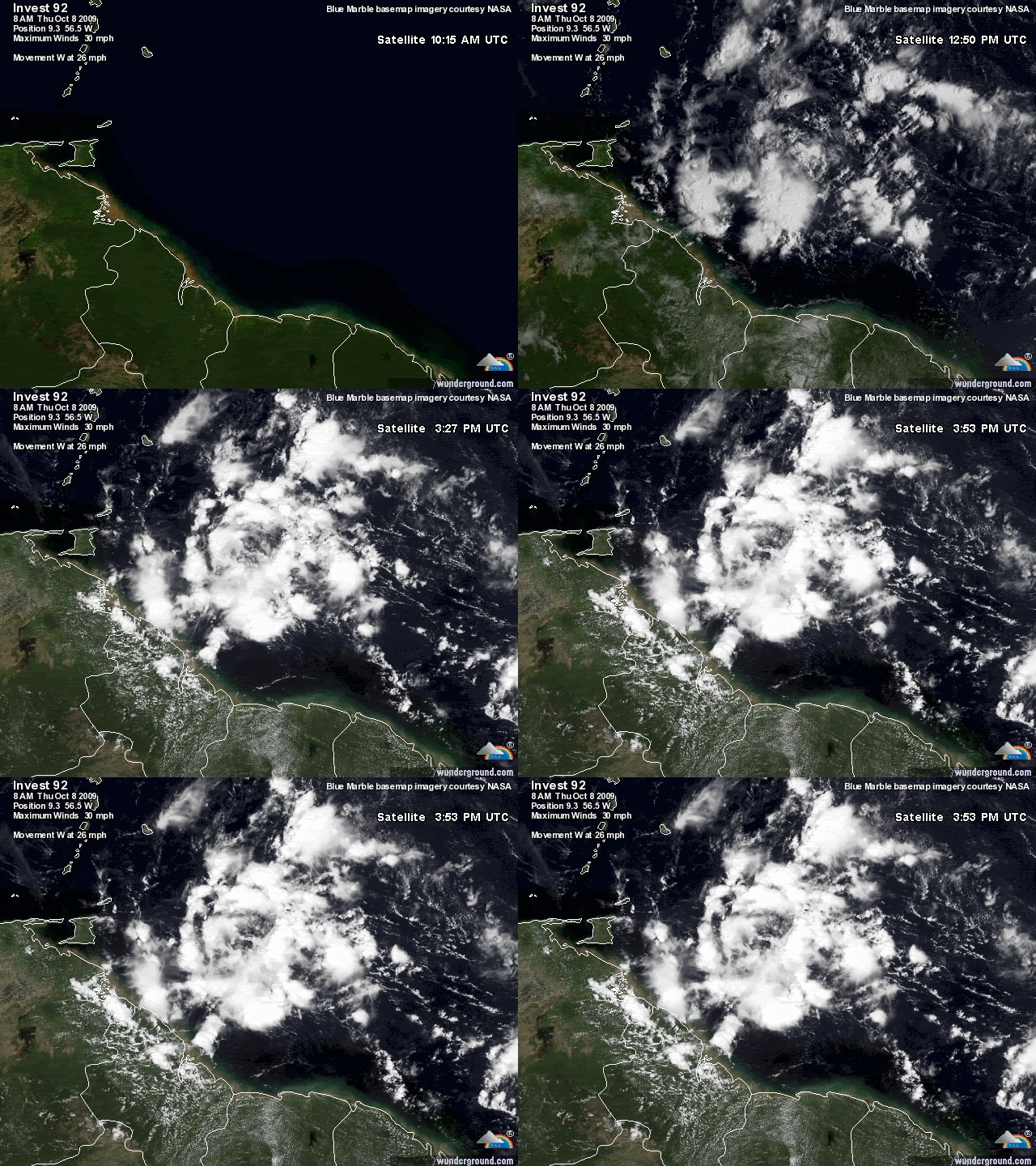
ATL : INVEST 92L

Moderator: S2k Moderators

Message
Author
User avatar
cycloneye
Admin
Admin
Posts: 139086
Age: 67
Joined: Thu Oct 10, 2002 10:54 am
Location: San Juan, Puerto Rico

Re: ATL : INVEST 92L

#21 Postby cycloneye » Thu Oct 08, 2009 10:47 am

TheEuropean wrote:Hi, this was the first thread about this system:

viewtopic.php?f=31&t=106794

Is is possible always to post here a link to the locked discussion thread in Talkin' Tropics in the first post of a new invest? Thx.


I forgot to add the link at the first post but is there now.Thanks for the reminder.
0 likes   
Visit the Caribbean-Central America Weather Thread where you can find at first post web cams,radars
and observations from Caribbean basin members Click Here

User avatar
HURAKAN
Professional-Met
Professional-Met
Posts: 46086
Age: 37
Joined: Thu May 20, 2004 4:34 pm
Location: Key West, FL
Contact:

#22 Postby HURAKAN » Thu Oct 08, 2009 10:59 am

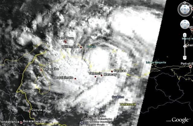
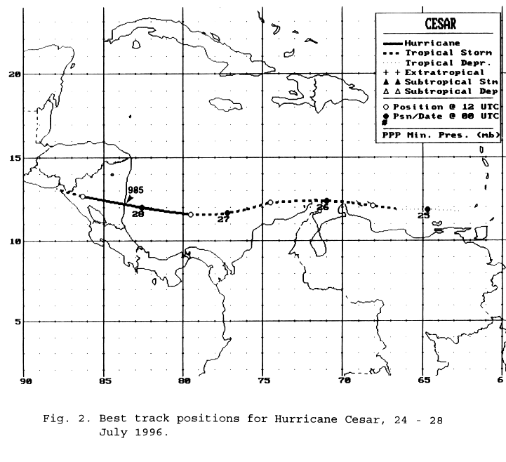
A track close to South America doesn't necessarily mean that it won't develop, as an example, here is Tropical Storm César (July 25, 1996)

Image

Image

It will be interesting if 92L can develop and be named, because if the track is correct, it will likely make a safe crossing into the Pacific and be the first storm to keep its name since the rule was implemented in 2001.
0 likes   

User avatar
Macrocane
Category 5
Category 5
Posts: 4218
Age: 35
Joined: Sun May 24, 2009 5:35 pm
Location: El Salvador

Re: ATL : INVEST 92L

#23 Postby Macrocane » Thu Oct 08, 2009 11:05 am

Cesar was a bad storm here in Central America, certainly something to keep both eyes on
0 likes   

User avatar
southerngale
Retired Staff
Retired Staff
Posts: 27420
Joined: Thu Oct 10, 2002 1:27 am
Location: Southeast Texas (Beaumont area)

Re: ATL : INVEST 92L

#24 Postby southerngale » Thu Oct 08, 2009 11:05 am

TheEuropean wrote:Hi, this was the first thread about this system:

viewtopic.php?f=31&t=106794

Is is possible always to post here a link to the locked discussion thread in Talkin' Tropics in the first post of a new invest? Thx.


Good idea. When an Invest, TD, etc. forms, we've asked staff to post a link in the TT thread to the new thread in Active Storms, but never thought to ask everyone to do the same here, for those who want a quick reference to the thread before it became an Invest, TD, or named storm. Thanks. :)
0 likes   
Please support Storm2k by making a donation today. It is greatly appreciated! Click here: Image

Image my Cowboys Image my RocketsImage my Astros

User avatar
HURAKAN
Professional-Met
Professional-Met
Posts: 46086
Age: 37
Joined: Thu May 20, 2004 4:34 pm
Location: Key West, FL
Contact:

#25 Postby HURAKAN » Thu Oct 08, 2009 11:11 am

Image

Sea Surface Temperatures won't be a problem.

Image

A long way to go
0 likes   

floridasun78
Category 5
Category 5
Posts: 3755
Joined: Sun May 17, 2009 10:16 pm
Location: miami fl

Re: ATL : INVEST 92L

#26 Postby floridasun78 » Thu Oct 08, 2009 11:16 am

why put invest on area that going run into land? and look weaker and other day when it look better it look like nhc few days late
0 likes   

Derek Ortt

#27 Postby Derek Ortt » Thu Oct 08, 2009 11:18 am

LGE also takes this to 85KT
0 likes   

User avatar
BigA
Professional-Met
Professional-Met
Posts: 1317
Joined: Sun Jul 24, 2005 10:56 pm

#28 Postby BigA » Thu Oct 08, 2009 11:18 am

The models look like they have initiated this system at 9.3 north (Initiating a system without a well-defined low-level center is always a craps-shoot), but it looks like if there is a spin developing, it is a bit north of 9.3, closer to 10.0 exactly. This may be academic, but it may also be the difference between being too close to SAM to develop, and being far enough north.
0 likes   

User avatar
HURAKAN
Professional-Met
Professional-Met
Posts: 46086
Age: 37
Joined: Thu May 20, 2004 4:34 pm
Location: Key West, FL
Contact:

Re: ATL : INVEST 92L

#29 Postby HURAKAN » Thu Oct 08, 2009 11:22 am

floridasun78 wrote:why put invest on area that going run into land? and look weaker and other day when it look better it look like nhc few days late


Since the models show the disturbance skirting the SA coast, there is a chance for development. If the path is further south, then there is no way but the disturbance may stay at a good distance from the coast to be able to develop and that's why it's an invest. I guess!
0 likes   

User avatar
BigA
Professional-Met
Professional-Met
Posts: 1317
Joined: Sun Jul 24, 2005 10:56 pm

Re: ATL : INVEST 92L

#30 Postby BigA » Thu Oct 08, 2009 11:23 am

floridasun78 wrote:why put invest on area that going run into land? and look weaker and other day when it look better it look like nhc few days late


I think that the NHC thinks that there is at least some chance that 92L moves north far enough to not be mauled by South America. Considering that it is at about 10.0 north right now, and 57.5 west, if it moves much at all north of due west it should be far enough north to clear Trinidad and Tobago (northern coast at 10.7 north, 61.1 west). And unlike almost every other system this year, upper level shear isn't really an issue. I think this is invest-worthy.
0 likes   

User avatar
HURAKAN
Professional-Met
Professional-Met
Posts: 46086
Age: 37
Joined: Thu May 20, 2004 4:34 pm
Location: Key West, FL
Contact:

#31 Postby HURAKAN » Thu Oct 08, 2009 11:26 am

Loop: http://rammb.cira.colostate.edu/ramsdis ... km_visible

I agree with BigA that the "center" or area of greatest rotation, appears to be close to 10°N and not 9.3°N like the model initiated.
0 likes   

User avatar
cycloneye
Admin
Admin
Posts: 139086
Age: 67
Joined: Thu Oct 10, 2002 10:54 am
Location: San Juan, Puerto Rico

Re: ATL : INVEST 92L

#32 Postby cycloneye » Thu Oct 08, 2009 11:42 am

Is the ridge going to be very strong to not allow 92L to go north and track all the way to the EPAC?
0 likes   
Visit the Caribbean-Central America Weather Thread where you can find at first post web cams,radars
and observations from Caribbean basin members Click Here

User avatar
wxman57
Moderator-Pro Met
Moderator-Pro Met
Posts: 22482
Age: 66
Joined: Sat Jun 21, 2003 8:06 pm
Location: Houston, TX (southwest)

Re: ATL : INVEST 92L

#33 Postby wxman57 » Thu Oct 08, 2009 11:44 am

cycloneye wrote:Is the ridge going to be very strong to not allow 92L to go north and track all the way to the EPAC?


The ridge to its north is currently strong and forecast to strengthen with time. This system is heading west.
0 likes   

User avatar
cycloneye
Admin
Admin
Posts: 139086
Age: 67
Joined: Thu Oct 10, 2002 10:54 am
Location: San Juan, Puerto Rico

Re: ATL : INVEST 92L - Models

#34 Postby cycloneye » Thu Oct 08, 2009 11:46 am

Lets see what GFDL and HWRF have in their first plots later this afternoon.
0 likes   
Visit the Caribbean-Central America Weather Thread where you can find at first post web cams,radars
and observations from Caribbean basin members Click Here

User avatar
HURAKAN
Professional-Met
Professional-Met
Posts: 46086
Age: 37
Joined: Thu May 20, 2004 4:34 pm
Location: Key West, FL
Contact:

#35 Postby HURAKAN » Thu Oct 08, 2009 11:55 am

Image

Like Lewis and Clark
0 likes   

User avatar
lrak
S2K Supporter
S2K Supporter
Posts: 1770
Age: 57
Joined: Thu Jun 21, 2007 2:48 pm
Location: Corpus Christi, TX

Re: ATL : INVEST 92L

#36 Postby lrak » Thu Oct 08, 2009 12:11 pm

took me a while but then I got it.... :lol: HURAKAN good one! History wasn't my favorite, unless it was WAR!
0 likes   
AKA karl

Also
Personal Forecast Disclaimer:
My posts on this forum are NOT official forecast and should not be used as such. My posts are my basic observations and are definitely not backed by any "well some" meteorological knowledge. For official information, please refer to the NHC and NWS products.

User avatar
HURAKAN
Professional-Met
Professional-Met
Posts: 46086
Age: 37
Joined: Thu May 20, 2004 4:34 pm
Location: Key West, FL
Contact:

Re: ATL : INVEST 92L

#37 Postby HURAKAN » Thu Oct 08, 2009 12:16 pm

lrak wrote:took me a while but then I got it.... :lol: HURAKAN good one! History wasn't my favorite, unless it was WAR!


For some reason it came to my mind Lewis and Clark when I read wxman57 post.
0 likes   

User avatar
cycloneye
Admin
Admin
Posts: 139086
Age: 67
Joined: Thu Oct 10, 2002 10:54 am
Location: San Juan, Puerto Rico

Re: ATL : INVEST 92L - Models

#38 Postby cycloneye » Thu Oct 08, 2009 12:22 pm

The first GFDL plots are only for 6 hours.

WHXX04 KWBC 081713
CHGQLM
ATTENTION...NATIONAL HURRICANE CENTER

NCEP UNCOUPLED GFDL HURRICANE MODEL FORECAST MADE FOR

TROPICAL DEPRESSION INVEST 92L

INITIAL TIME 12Z OCT 8

DISCLAIMER ... THIS INFORMATION IS PROVIDED AS GUIDANCE. IT
REQUIRES INTERPRETATION BY HURRICANE SPECIALISTS AND SHOULD
NOT BE CONSIDERED AS A FINAL PRODUCT. PLEASE SEE THE TPC/NHC
OFFICIAL FORECAST.


FORECAST STORM POSITION

HOUR LATITUDE LONGITUDE HEADING/SPEED(KT)

0 8.8 56.9 280./22.9
6 9.6 58.6 295./18.7

STORM DISSIPATED AT 6 HRS AT THE ABOVE PSN.

0 likes   
Visit the Caribbean-Central America Weather Thread where you can find at first post web cams,radars
and observations from Caribbean basin members Click Here

User avatar
Blown Away
S2K Supporter
S2K Supporter
Posts: 9862
Joined: Wed May 26, 2004 6:17 am

Re: ATL : INVEST 92L

#39 Postby Blown Away » Thu Oct 08, 2009 12:27 pm

Convection really starting to build.
http://www.ssd.noaa.gov/goes/east/tatl/loop-avn.html
0 likes   
Hurricane Eye Experience: David 79, Irene 99, Frances 04, Jeanne 04, Wilma 05...
Hurricane Brush Experience: Andrew 92, Erin 95, Floyd 99, Matthew 16, Irma 17, Ian 22, Nicole 22…

User avatar
HURAKAN
Professional-Met
Professional-Met
Posts: 46086
Age: 37
Joined: Thu May 20, 2004 4:34 pm
Location: Key West, FL
Contact:

#40 Postby HURAKAN » Thu Oct 08, 2009 12:32 pm

:uarrow: Wrong initiation, 8.8°N.
0 likes   


Return to “2009”

Who is online

Users browsing this forum: No registered users and 119 guests