WPAC: SEVERE TROPICAL STORM LUPIT (22W)
Moderator: S2k Moderators
-
beaufort12
- S2K Supporter

- Posts: 70
- Joined: Thu Sep 02, 2004 9:18 am
- Location: Lorton VA
Re: WPAC: TROPICAL DEPRESSION 22W
Yes, this is moving into prime territory, and unfortunately, it's also looking all too familiar.
0 likes

-
P.K.

- Professional-Met

- Posts: 5149
- Joined: Thu Sep 23, 2004 5:57 pm
- Location: Watford, England
- Contact:
Re: WPAC: TROPICAL DEPRESSION 22W
WTPQ20 RJTD 141800
RSMC TROPICAL CYCLONE ADVISORY
NAME TD
ANALYSIS
PSTN 141800UTC 11.2N 146.8E POOR
MOVE W 22KT
PRES 1004HPA
MXWD 030KT
GUST 045KT
FORECAST
24HF 151800UTC 13.5N 141.3E 120NM 70%
MOVE WNW 15KT
PRES 1000HPA
MXWD 035KT
GUST 050KT =
RSMC TROPICAL CYCLONE ADVISORY
NAME TD
ANALYSIS
PSTN 141800UTC 11.2N 146.8E POOR
MOVE W 22KT
PRES 1004HPA
MXWD 030KT
GUST 045KT
FORECAST
24HF 151800UTC 13.5N 141.3E 120NM 70%
MOVE WNW 15KT
PRES 1000HPA
MXWD 035KT
GUST 050KT =
0 likes
-
HURAKAN

- Professional-Met
- Posts: 46086
- Age: 37
- Joined: Thu May 20, 2004 4:34 pm
- Location: Key West, FL
- Contact:
Re: WPAC: TROPICAL DEPRESSION 22W
TPPN11 PGTW 141843
A. TROPICAL DEPRESSION 22W (SE OF GUAM)
B. 13/1730Z
C. 11.0N
D. 146.5E
E. SIX/MTSAT
F. T2.0/2.0/S0.0/18HRS STT: D0.5/06HRS
G. IR/EIR
H. REMARKS: 38A/PBO SBC/ANMTN. CONVECTION WRAPPED A .30 ON LOG10
SPIRAL YIELDING A DT OF 2.0. MET YIELDS A 2.0. PT YIELDS A 2.5.
DBO DT.
I. ADDITIONAL POSITIONS: NONE
BRANDON
0 likes
-
ozonepete
- Professional-Met
- Posts: 4743
- Joined: Mon Sep 07, 2009 3:23 pm
- Location: From Ozone Park, NYC / Now in Brooklyn, NY
Re: WPAC: TROPICAL DEPRESSION 22W
Wow! Another major threat for Luzon in the Philippines. JTWC now has a 100 knot typhoon bearing down on the area around Monday. The Pacific is certainly making up for the Atlantic.
0 likes
-
oaba09
- S2K Supporter
- Posts: 1496
- Age: 37
- Joined: Thu Oct 01, 2009 10:02 am
- Location: Valenzuela, Philippines
- Contact:
Re: WPAC: TROPICAL DEPRESSION 22W
surprisingly though, our local weather bureau(PAGASA) hasn't issued any warnings yet....This threat is not even on our news........This is the reason why I rely on the JTWC when it comes to typhoons.......
0 likes
-
ozonepete
- Professional-Met
- Posts: 4743
- Joined: Mon Sep 07, 2009 3:23 pm
- Location: From Ozone Park, NYC / Now in Brooklyn, NY
Re: WPAC: TROPICAL DEPRESSION 22W
oaba09 wrote:surprisingly though, our local weather bureau(PAGASA) hasn't issued any warnings yet....This threat is not even on our news........This is the reason why I rely on the JTWC when it comes to typhoons.......
It's still at least 5 days away and not even declared a TS yet. That must be why they don't want to say anything yet. Here in New York City, when the local Weather Service starts putting a hurricane in the forecast, the city has to start spending millions of dollars in storm preparations.
0 likes
-
Cookie

- S2K Supporter
- Posts: 477
- Age: 36
- Joined: Sun Dec 14, 2008 11:13 am
- Location: Isle Of lewis scotland
Re: WPAC: TROPICAL DEPRESSION 22W
oaba09 wrote:surprisingly though, our local weather bureau(PAGASA) hasn't issued any warnings yet....This threat is not even on our news........This is the reason why I rely on the JTWC when it comes to typhoons.......
hopefully these areas will already be prepared after the other systems this year.
0 likes
-
StormingB81

- S2K Supporter
- Posts: 5676
- Age: 42
- Joined: Thu Aug 27, 2009 1:45 am
- Location: Rockledge, Florida
-
cycloneye

- Admin

- Posts: 139162
- Age: 67
- Joined: Thu Oct 10, 2002 10:54 am
- Location: San Juan, Puerto Rico
Re: WPAC: TROPICAL DEPRESSION 22W
000
WTPQ31 PGUM 142119 CCA
TCPPQ1
BULLETIN
TROPICAL STORM 22W ADVISORY NUMBER 4...CORRECTION
NATIONAL WEATHER SERVICE TIYAN GU WP222009
800 AM CHST THU OCT 15 2009
CORRECTION TO TYPOS
...TROPICAL DEPRESSION 22W BECOMES A TROPICAL STORM...
...A TROPICAL STORM WATCH REMAINS IN EFFECT FOR GUAM...
A TROPICAL STORM WATCH MEANS TROPICAL-STORM FORCE WINDS OF 39 MPH OR
HIGHER ARE POSSIBLE IN THE NEXT 24 TO 48 HOURS.
AT 700 AM CHST...2100Z...THE CENTER OF TROPICAL STORM 22W WAS
LOCATED NEAR LATITUDE 11.2 DEGREES NORTH AND LONGITUDE 145.7
DEGREES EAST.
THIS IS ABOUT 170 MILES SOUTH-SOUTHEAST OF GUAM
205 MILES SOUTH OF ROTA
260 MILES SOUTH OF TINIAN
270 MILES SOUTH OF SAIPAN AND
365 MILES EAST-NORTHEAST OF FAIS.
TROPICAL STORM 22W IS MOVING WEST AT 26 MPH. THE TROPICAL STORM IS
EXPECTED TO DECREASE IN FORWARD SPEED DURING THE NEXT 12 HOURS
WHILE CONTINUING ON ITS CURRENT TRACK. BASED ON THE CURRENT
TRACK...22W WILL PASS SOUTH OF GUAM ON THIS AFTERNOON.
MAXIMUM SUSTAINED WINDS ARE 40 MPH. TROPICAL STORM 22W IS EXPECTED
TO INTENSIFY SLOWLY DURING THE NEXT 12 TO 24 HOURS.
REPEATING THE 700 AM CHST POSITION...LATITUDE 11.2 DEGREES NORTH AND
LONGITUDE 145.7 DEGREES EAST...MOVING WEST AT 26 MPH WITH MAXIMUM
SUSTAINED WINDS OF 40 MPH.
AN INTERMEDIATE ADVISORY WILL BE ISSUED BY THE NATIONAL WEATHER
SERVICE AT 1100 AM CHST LATER THIS MORNING...THEN FOLLOWED BY AN
ADVISORY AT 200 PM THIS AFTERNOON.
$$
ZIOBRO
0 likes
Visit the Caribbean-Central America Weather Thread where you can find at first post web cams,radars
and observations from Caribbean basin members Click Here
and observations from Caribbean basin members Click Here
-
cycloneye
- Admin
- Posts: 139162
- Age: 67
- Joined: Thu Oct 10, 2002 10:54 am
- Location: San Juan, Puerto Rico
Re: WPAC: TROPICAL DEPRESSION 22W
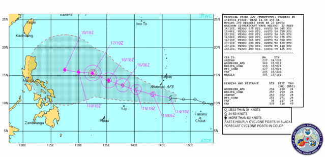
0300z Warning=JTWC Upgrades to Tropical Storm
WTPN31 PGTW 150300
MSGID/GENADMIN/NAVMARFCSTCEN PEARL HARBOR HI/JTWC//
SUBJ/TROPICAL CYCLONE WARNING//
RMKS/
1. TROPICAL STORM 22W (TWENTYTWO) WARNING NR 005
02 ACTIVE TROPICAL CYCLONES IN NORTHWESTPAC
MAX SUSTAINED WINDS BASED ON ONE-MINUTE AVERAGE
WIND RADII VALID OVER OPEN WATER ONLY
---
WARNING POSITION:
150000Z --- NEAR 11.6N 144.7E
MOVEMENT PAST SIX HOURS - 290 DEGREES AT 19 KTS
POSITION ACCURATE TO WITHIN 060 NM
POSITION BASED ON CENTER LOCATED BY SATELLITE
PRESENT WIND DISTRIBUTION:
MAX SUSTAINED WINDS - 035 KT, GUSTS 045 KT
WIND RADII VALID OVER OPEN WATER ONLY
REPEAT POSIT: 11.6N 144.7E
---
FORECASTS:
12 HRS, VALID AT:
151200Z --- 12.5N 141.4E
MAX SUSTAINED WINDS - 040 KT, GUSTS 050 KT
WIND RADII VALID OVER OPEN WATER ONLY
RADIUS OF 034 KT WINDS - 025 NM NORTHEAST QUADRANT
025 NM SOUTHEAST QUADRANT
025 NM SOUTHWEST QUADRANT
025 NM NORTHWEST QUADRANT
VECTOR TO 24 HR POSIT: 285 DEG/ 15 KTS
---
24 HRS, VALID AT:
160000Z --- 13.2N 138.4E
MAX SUSTAINED WINDS - 050 KT, GUSTS 065 KT
WIND RADII VALID OVER OPEN WATER ONLY
RADIUS OF 034 KT WINDS - 060 NM NORTHEAST QUADRANT
050 NM SOUTHEAST QUADRANT
050 NM SOUTHWEST QUADRANT
060 NM NORTHWEST QUADRANT
VECTOR TO 36 HR POSIT: 290 DEG/ 12 KTS
---
36 HRS, VALID AT:
161200Z --- 14.1N 136.0E
MAX SUSTAINED WINDS - 060 KT, GUSTS 075 KT
WIND RADII VALID OVER OPEN WATER ONLY
RADIUS OF 050 KT WINDS - 015 NM NORTHEAST QUADRANT
010 NM SOUTHEAST QUADRANT
010 NM SOUTHWEST QUADRANT
015 NM NORTHWEST QUADRANT
RADIUS OF 034 KT WINDS - 075 NM NORTHEAST QUADRANT
070 NM SOUTHEAST QUADRANT
070 NM SOUTHWEST QUADRANT
075 NM NORTHWEST QUADRANT
VECTOR TO 48 HR POSIT: 285 DEG/ 10 KTS
---
EXTENDED OUTLOOK:
48 HRS, VALID AT:
170000Z --- 14.6N 134.1E
MAX SUSTAINED WINDS - 065 KT, GUSTS 080 KT
WIND RADII VALID OVER OPEN WATER ONLY
RADIUS OF 050 KT WINDS - 030 NM NORTHEAST QUADRANT
025 NM SOUTHEAST QUADRANT
025 NM SOUTHWEST QUADRANT
030 NM NORTHWEST QUADRANT
RADIUS OF 034 KT WINDS - 085 NM NORTHEAST QUADRANT
080 NM SOUTHEAST QUADRANT
080 NM SOUTHWEST QUADRANT
085 NM NORTHWEST QUADRANT
VECTOR TO 72 HR POSIT: 300 DEG/ 05 KTS
---
72 HRS, VALID AT:
180000Z --- 15.6N 132.2E
MAX SUSTAINED WINDS - 080 KT, GUSTS 100 KT
WIND RADII VALID OVER OPEN WATER ONLY
RADIUS OF 064 KT WINDS - 030 NM NORTHEAST QUADRANT
025 NM SOUTHEAST QUADRANT
025 NM SOUTHWEST QUADRANT
030 NM NORTHWEST QUADRANT
RADIUS OF 050 KT WINDS - 045 NM NORTHEAST QUADRANT
045 NM SOUTHEAST QUADRANT
045 NM SOUTHWEST QUADRANT
045 NM NORTHWEST QUADRANT
RADIUS OF 034 KT WINDS - 090 NM NORTHEAST QUADRANT
085 NM SOUTHEAST QUADRANT
085 NM SOUTHWEST QUADRANT
090 NM NORTHWEST QUADRANT
VECTOR TO 96 HR POSIT: 280 DEG/ 05 KTS
---
LONG RANGE OUTLOOK:
NOTE...ERRORS FOR TRACK HAVE AVERAGED NEAR 250 NM
ON DAY 4 AND 350 NM ON DAY 5... AND FOR INTENSITY
NEAR 20 KT EACH DAY.
---
96 HRS, VALID AT:
190000Z --- 15.9N 130.3E
MAX SUSTAINED WINDS - 090 KT, GUSTS 110 KT
WIND RADII VALID OVER OPEN WATER ONLY
VECTOR TO 120 HR POSIT: 275 DEG/ 06 KTS
---
120 HRS, VALID AT:
200000Z --- 16.2N 127.7E
MAX SUSTAINED WINDS - 100 KT, GUSTS 125 KT
WIND RADII VALID OVER OPEN WATER ONLY
---
REMARKS:
150300Z POSITION NEAR 11.8N 143.9E.
MAXIMUM SIGNIFICANT WAVE HEIGHT AT 150000Z IS 12 FEET.
TROPICAL STORM 22W (TWENTYTWO), LOCATED APPROXIMATELY 110 NM SOUTH
OF GUAM, HAS TRACKED WEST-NORTHWESTWARD AT 19 KNOTS OVER THE PAST
SIX HOURS. NEXT WARNINGS AT 150900Z, 151500Z, 152100Z AND 160300Z.
//
NNNN
0 likes
Visit the Caribbean-Central America Weather Thread where you can find at first post web cams,radars
and observations from Caribbean basin members Click Here
and observations from Caribbean basin members Click Here
-
cycloneye
- Admin
- Posts: 139162
- Age: 67
- Joined: Thu Oct 10, 2002 10:54 am
- Location: San Juan, Puerto Rico
Re: WPAC: TROPICAL DEPRESSION 22W
JMA still has it as a Tropical Depression.
TD
Issued at 01:10 UTC, 15 October 2009
<Analyses at 15/00 UTC>
Scale -
Intensity -
TD
Center position N11°20'(11.3°)
E144°30'(144.5°)
Direction and speed of movement W 40km/h(22kt)
Central pressure 1004hPa
Maximum wind speed near the center 15m/s(30kt)
Maximum wind gust speed 23m/s(45kt)
TD
Issued at 01:10 UTC, 15 October 2009
<Analyses at 15/00 UTC>
Scale -
Intensity -
TD
Center position N11°20'(11.3°)
E144°30'(144.5°)
Direction and speed of movement W 40km/h(22kt)
Central pressure 1004hPa
Maximum wind speed near the center 15m/s(30kt)
Maximum wind gust speed 23m/s(45kt)
0 likes
Visit the Caribbean-Central America Weather Thread where you can find at first post web cams,radars
and observations from Caribbean basin members Click Here
and observations from Caribbean basin members Click Here

Re: WPAC: TROPICAL DEPRESSION 22W
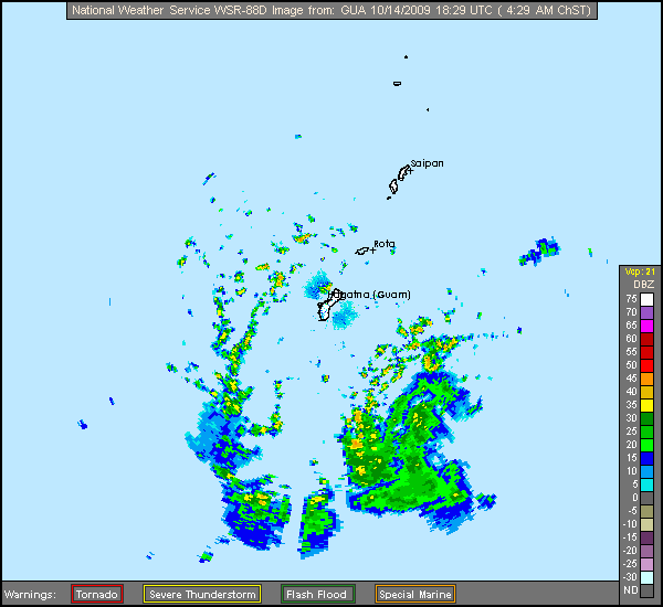
Not much rain so far here in Tamuning, Guam. There was a short shower early this morning (11:40am now) but not much since. The winds have picked up a little. I thought there would be more rain but looks like radar has it spiraling just to our south. You can see the low clouds moving quickly across the sky. Telltale signs of something tropical nearby.
12:20 pm update: just after I wrote this it started raining horizontally !
12:20 pm update: just after I wrote this it started raining horizontally !
Last edited by JTE50 on Wed Oct 14, 2009 9:20 pm, edited 1 time in total.
0 likes
-
drdavisjr

- Category 1

- Posts: 428
- Age: 56
- Joined: Mon Oct 12, 2009 7:07 am
- Location: Marilao, Bulacan, Philippines
- Contact:
Re: WPAC: TROPICAL DEPRESSION 22W
oaba09 wrote:surprisingly though, our local weather bureau(PAGASA) hasn't issued any warnings yet....This threat is not even on our news........This is the reason why I rely on the JTWC when it comes to typhoons.......
I'm very sorry to say, but PAGASA is a joke. Consider that we live in a country that has on average 20 typhoons per year enter the Philippine Area of Responsibility and not even 1 Doppler radar.
I guess the only good news (for us in Manila) so far from this forecast is that 22W won't be a Supertyphoon and that it might not be a direct hit on Manila.
0 likes
-
ozonepete
- Professional-Met
- Posts: 4743
- Joined: Mon Sep 07, 2009 3:23 pm
- Location: From Ozone Park, NYC / Now in Brooklyn, NY
Re: WPAC: TROPICAL DEPRESSION 22W
drdavisjr wrote:oaba09 wrote:surprisingly though, our local weather bureau(PAGASA) hasn't issued any warnings yet....This threat is not even on our news........This is the reason why I rely on the JTWC when it comes to typhoons.......
I'm very sorry to say, but PAGASA is a joke. Consider that we live in a country that has on average 20 typhoons per year enter the Philippine Area of Responsibility and not even 1 Doppler radar.
I guess the only good news (for us in Manila) so far from this forecast is that 22W won't be a Supertyphoon and that it might not be a direct hit on Manila.
I'm sorry to hear that. That really is a shame. But as far as this one goes, it's way too early to tell or worry about yet.
On a personal note, I would love to live out there. It looks so beautiful, and I've met a lot of really nice people from there.
0 likes
-
drdavisjr
- Category 1
- Posts: 428
- Age: 56
- Joined: Mon Oct 12, 2009 7:07 am
- Location: Marilao, Bulacan, Philippines
- Contact:
Re: WPAC: TROPICAL DEPRESSION 22W
ozonepete wrote:drdavisjr wrote:oaba09 wrote:surprisingly though, our local weather bureau(PAGASA) hasn't issued any warnings yet....This threat is not even on our news........This is the reason why I rely on the JTWC when it comes to typhoons.......
I'm very sorry to say, but PAGASA is a joke. Consider that we live in a country that has on average 20 typhoons per year enter the Philippine Area of Responsibility and not even 1 Doppler radar.
I guess the only good news (for us in Manila) so far from this forecast is that 22W won't be a Supertyphoon and that it might not be a direct hit on Manila.
I'm sorry to hear that. That really is a shame. But as far as this one goes, it's way too early to tell or worry about yet.
On a personal note, I would love to live out there. It looks so beautiful, and I've met a lot of really nice people from there.
It is beautiful here and the people are absolutely wonderful. I'm not Filipino, so I say this very objectively.
0 likes
-
dowdavek
- Tropical Low

- Posts: 41
- Age: 31
- Joined: Thu Jul 09, 2009 4:06 am
- Location: Dededo, Guam
- Contact:
Re: WPAC: TROPICAL DEPRESSION 22W
In Dededo (Northern Guam) we just had some strong wind about 30.min ago and heavy rain, not much on the radar for us but the storms that do pop up are pretty intense. I estimate the wind gust from earlier to be around 50 -55 mph. A lot of tree branches and other plant material were scattered about my yard.
0 likes
David D. 
-
HURAKAN
- Professional-Met
- Posts: 46086
- Age: 37
- Joined: Thu May 20, 2004 4:34 pm
- Location: Key West, FL
- Contact:
Re: WPAC: TROPICAL DEPRESSION 22W
ZCZC 751
WTPQ20 RJTD 150000
RSMC TROPICAL CYCLONE ADVISORY
NAME TD
ANALYSIS
PSTN 150000UTC 11.3N 144.5E POOR
MOVE W 22KT
PRES 1004HPA
MXWD 030KT
GUST 045KT
FORECAST
24HF 160000UTC 13.8N 138.8E 120NM 70%
MOVE WNW 15KT
PRES 996HPA
MXWD 040KT
GUST 060KT =
NNNN
WTPQ20 RJTD 150000
RSMC TROPICAL CYCLONE ADVISORY
NAME TD
ANALYSIS
PSTN 150000UTC 11.3N 144.5E POOR
MOVE W 22KT
PRES 1004HPA
MXWD 030KT
GUST 045KT
FORECAST
24HF 160000UTC 13.8N 138.8E 120NM 70%
MOVE WNW 15KT
PRES 996HPA
MXWD 040KT
GUST 060KT =
NNNN
0 likes

Who is online
Users browsing this forum: No registered users and 61 guests