WPAC : TROPICAL DEPRESSION NIDA (26W)
Moderator: S2k Moderators
-
ozonepete
- Professional-Met

- Posts: 4743
- Joined: Mon Sep 07, 2009 3:23 pm
- Location: From Ozone Park, NYC / Now in Brooklyn, NY
Re: WPAC : TYPHOON NIDA (26W)
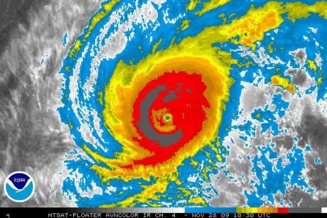
This is a very powerful storm; I'm very impressed. It may even do another ERC. But in the end, it's already moved into the zone where it has to recurve. It just doesn't have anywhere else to go since it's so close to the westerlies...
0 likes
-
oaba09
- S2K Supporter

- Posts: 1496
- Age: 37
- Joined: Thu Oct 01, 2009 10:02 am
- Location: Valenzuela, Philippines
- Contact:
Re: WPAC : TYPHOON NIDA (26W)
ozonepete wrote:
LOL! I'll see you that 10 and raise you 10.
LOL!
Seriously though, I just don't see how it could go west to SW.........The NE of the typhoon is quite clear.......Maybe JMA is expecting for it to weaken significantly....
0 likes
-
ozonepete
- Professional-Met
- Posts: 4743
- Joined: Mon Sep 07, 2009 3:23 pm
- Location: From Ozone Park, NYC / Now in Brooklyn, NY
Re: WPAC : TYPHOON NIDA (26W)
oaba09 wrote:ozonepete wrote:
LOL! I'll see you that 10 and raise you 10.
LOL!
Seriously though, I just don't see how it could go west to SW.........The NE of the typhoon is quite clear.......Maybe JMA is expecting for it to weaken significantly....
Yes, the JMA analysis may be assuming that the upper portions of Nida gets sheared off and the low level center goes westward, but those forecasts have busted every time this season.
0 likes
-
oaba09
- S2K Supporter
- Posts: 1496
- Age: 37
- Joined: Thu Oct 01, 2009 10:02 am
- Location: Valenzuela, Philippines
- Contact:
Re: WPAC : TYPHOON NIDA (26W)
ozonepete wrote:oaba09 wrote:ozonepete wrote:
LOL! I'll see you that 10 and raise you 10.
LOL!
Seriously though, I just don't see how it could go west to SW.........The NE of the typhoon is quite clear.......Maybe JMA is expecting for it to weaken significantly....
Yes, the JMA analysis may be assuming that the upper portions of Nida gets sheared off and the low level center goes westward, but those forecasts have busted every time this season.
Well...at least if JMA's prediction does hold, it will just be a weak system....
0 likes
-
ricmood
-
ozonepete
- Professional-Met
- Posts: 4743
- Joined: Mon Sep 07, 2009 3:23 pm
- Location: From Ozone Park, NYC / Now in Brooklyn, NY
Re:
ricmood wrote:Will this storm weaken IF in case it turns west and comes near/ hit philippines?
There seems to be just about no chance this will come near the Philippines. But I have to say it is a very impressive tropical cyclone right now. As I said before, it looks like it might be doing another ERC. Very impressive.
0 likes
-
ozonepete
- Professional-Met
- Posts: 4743
- Joined: Mon Sep 07, 2009 3:23 pm
- Location: From Ozone Park, NYC / Now in Brooklyn, NY
Re:
oaba09 wrote:It'd be interesting what the next JMA advisory will show....It should be updated in about 10-20 minutes....
I hope they come up with a smarter forecast this time....
0 likes
-
ozonepete
- Professional-Met
- Posts: 4743
- Joined: Mon Sep 07, 2009 3:23 pm
- Location: From Ozone Park, NYC / Now in Brooklyn, NY
Re: WPAC : TYPHOON NIDA (26W)
Also very late for me. Going to bed now. See you all tomorrow. 
0 likes
-
oaba09
- S2K Supporter
- Posts: 1496
- Age: 37
- Joined: Thu Oct 01, 2009 10:02 am
- Location: Valenzuela, Philippines
- Contact:
Re: WPAC : TYPHOON NIDA (26W)
ozonepete wrote:Also very late for me. Going to bed now. See you all tomorrow.
G'night pete!
0 likes
-
cycloneye

- Admin

- Posts: 139082
- Age: 67
- Joined: Thu Oct 10, 2002 10:54 am
- Location: San Juan, Puerto Rico
Re: WPAC : TYPHOON NIDA (26W)
JMA 12:50 UTC Warning
No change in the track.
TY 0922 (Nida)
Issued at 12:50 UTC, 28 November 2009
<Analyses at 28/12 UTC>
Scale -
Intensity Very Strong
Center position N19°00'(19.0°)
E139°20'(139.3°)
Direction and speed of movement STR
Central pressure 925hPa
Maximum wind speed near the center 50m/s(95kt)
Maximum wind gust speed 70m/s(135kt)
Area of 50kt winds or more Wide 130km(70NM)
Area of 30kt winds or more N480km(260NM)
S300km(160NM)
<Forecast for 29/12 UTC>
Intensity Very Strong
Center position of probability circle N19°20'(19.3°)
E138°40'(138.7°)
Direction and speed of movement STR
Central pressure 935hPa
Maximum wind speed near the center 45m/s(85kt)
Maximum wind gust speed 60m/s(120kt)
Radius of probability circle 130km(70NM)
Storm warning area Wide 240km(130NM)
<Forecast for 30/12 UTC>
Intensity Strong
Center position of probability circle N19°35'(19.6°)
E138°00'(138.0°)
Direction and speed of movement STR
Central pressure 945hPa
Maximum wind speed near the center 40m/s(80kt)
Maximum wind gust speed 60m/s(115kt)
Radius of probability circle 200km(110NM)
Storm warning area Wide 300km(160NM)
<Forecast for 01/12 UTC>
Intensity Strong
Center position of probability circle N19°40'(19.7°)
E137°00'(137.0°)
Direction and speed of movement STR
Central pressure 960hPa
Maximum wind speed near the center 40m/s(75kt)
Maximum wind gust speed 55m/s(105kt)
Radius of probability circle 300km(160NM)
Storm warning area Wide 370km(200NM)
0 likes
Visit the Caribbean-Central America Weather Thread where you can find at first post web cams,radars
and observations from Caribbean basin members Click Here
and observations from Caribbean basin members Click Here

-
cycloneye
- Admin
- Posts: 139082
- Age: 67
- Joined: Thu Oct 10, 2002 10:54 am
- Location: San Juan, Puerto Rico
Re: WPAC : TYPHOON NIDA (26W)
JTWC 12:00Z Warning - 140 KTS
WTPN31 PGTW 281500
MSGID/GENADMIN/NAVMARFCSTCEN PEARL HARBOR HI/JTWC//
SUBJ/TROPICAL CYCLONE WARNING//
RMKS/
1. SUPER TYPHOON 26W (NIDA) WARNING NR 027
01 ACTIVE TROPICAL CYCLONE IN NORTHWESTPAC
MAX SUSTAINED WINDS BASED ON ONE-MINUTE AVERAGE
WIND RADII VALID OVER OPEN WATER ONLY
---
WARNING POSITION:
281200Z --- NEAR 19.2N 139.3E
MOVEMENT PAST SIX HOURS - 025 DEGREES AT 02 KTS
POSITION ACCURATE TO WITHIN 020 NM
POSITION BASED ON EYE FIXED BY SATELLITE
PRESENT WIND DISTRIBUTION:
MAX SUSTAINED WINDS - 140 KT, GUSTS 170 KT
WIND RADII VALID OVER OPEN WATER ONLY
RADIUS OF 064 KT WINDS - 055 NM NORTHEAST QUADRANT
055 NM SOUTHEAST QUADRANT
050 NM SOUTHWEST QUADRANT
050 NM NORTHWEST QUADRANT
RADIUS OF 050 KT WINDS - 080 NM NORTHEAST QUADRANT
080 NM SOUTHEAST QUADRANT
075 NM SOUTHWEST QUADRANT
075 NM NORTHWEST QUADRANT
RADIUS OF 034 KT WINDS - 130 NM NORTHEAST QUADRANT
120 NM SOUTHEAST QUADRANT
115 NM SOUTHWEST QUADRANT
135 NM NORTHWEST QUADRANT
REPEAT POSIT: 19.2N 139.3E
---
FORECASTS:
12 HRS, VALID AT:
290000Z --- 19.9N 139.6E
MAX SUSTAINED WINDS - 130 KT, GUSTS 160 KT
WIND RADII VALID OVER OPEN WATER ONLY
RADIUS OF 064 KT WINDS - 050 NM NORTHEAST QUADRANT
050 NM SOUTHEAST QUADRANT
045 NM SOUTHWEST QUADRANT
045 NM NORTHWEST QUADRANT
RADIUS OF 050 KT WINDS - 080 NM NORTHEAST QUADRANT
080 NM SOUTHEAST QUADRANT
075 NM SOUTHWEST QUADRANT
075 NM NORTHWEST QUADRANT
RADIUS OF 034 KT WINDS - 135 NM NORTHEAST QUADRANT
130 NM SOUTHEAST QUADRANT
125 NM SOUTHWEST QUADRANT
135 NM NORTHWEST QUADRANT
VECTOR TO 24 HR POSIT: 030 DEG/ 03 KTS
---
24 HRS, VALID AT:
291200Z --- 20.4N 139.9E
MAX SUSTAINED WINDS - 125 KT, GUSTS 150 KT
WIND RADII VALID OVER OPEN WATER ONLY
RADIUS OF 064 KT WINDS - 045 NM NORTHEAST QUADRANT
045 NM SOUTHEAST QUADRANT
045 NM SOUTHWEST QUADRANT
045 NM NORTHWEST QUADRANT
RADIUS OF 050 KT WINDS - 075 NM NORTHEAST QUADRANT
075 NM SOUTHEAST QUADRANT
075 NM SOUTHWEST QUADRANT
070 NM NORTHWEST QUADRANT
RADIUS OF 034 KT WINDS - 135 NM NORTHEAST QUADRANT
135 NM SOUTHEAST QUADRANT
130 NM SOUTHWEST QUADRANT
135 NM NORTHWEST QUADRANT
VECTOR TO 36 HR POSIT: 045 DEG/ 05 KTS
---
36 HRS, VALID AT:
300000Z --- 21.1N 140.7E
MAX SUSTAINED WINDS - 100 KT, GUSTS 125 KT
WIND RADII VALID OVER OPEN WATER ONLY
RADIUS OF 064 KT WINDS - 040 NM NORTHEAST QUADRANT
040 NM SOUTHEAST QUADRANT
040 NM SOUTHWEST QUADRANT
040 NM NORTHWEST QUADRANT
RADIUS OF 050 KT WINDS - 070 NM NORTHEAST QUADRANT
070 NM SOUTHEAST QUADRANT
065 NM SOUTHWEST QUADRANT
065 NM NORTHWEST QUADRANT
RADIUS OF 034 KT WINDS - 140 NM NORTHEAST QUADRANT
140 NM SOUTHEAST QUADRANT
130 NM SOUTHWEST QUADRANT
135 NM NORTHWEST QUADRANT
VECTOR TO 48 HR POSIT: 045 DEG/ 06 KTS
---
EXTENDED OUTLOOK:
48 HRS, VALID AT:
301200Z --- 22.0N 141.6E
MAX SUSTAINED WINDS - 075 KT, GUSTS 090 KT
WIND RADII VALID OVER OPEN WATER ONLY
RADIUS OF 064 KT WINDS - 025 NM NORTHEAST QUADRANT
025 NM SOUTHEAST QUADRANT
025 NM SOUTHWEST QUADRANT
025 NM NORTHWEST QUADRANT
RADIUS OF 050 KT WINDS - 050 NM NORTHEAST QUADRANT
055 NM SOUTHEAST QUADRANT
050 NM SOUTHWEST QUADRANT
050 NM NORTHWEST QUADRANT
RADIUS OF 034 KT WINDS - 130 NM NORTHEAST QUADRANT
130 NM SOUTHEAST QUADRANT
120 NM SOUTHWEST QUADRANT
125 NM NORTHWEST QUADRANT
VECTOR TO 72 HR POSIT: 040 DEG/ 05 KTS
---
72 HRS, VALID AT:
011200Z --- 23.5N 143.1E
MAX SUSTAINED WINDS - 050 KT, GUSTS 065 KT
WIND RADII VALID OVER OPEN WATER ONLY
BECOMING EXTRATROPICAL
RADIUS OF 034 KT WINDS - 075 NM NORTHEAST QUADRANT
080 NM SOUTHEAST QUADRANT
070 NM SOUTHWEST QUADRANT
070 NM NORTHWEST QUADRANT
VECTOR TO 96 HR POSIT: 060 DEG/ 14 KTS
---
LONG RANGE OUTLOOK:
NOTE...ERRORS FOR TRACK HAVE AVERAGED NEAR 250 NM
ON DAY 4 AND 350 NM ON DAY 5... AND FOR INTENSITY
NEAR 20 KT EACH DAY.
---
96 HRS, VALID AT:
021200Z --- 26.1N 148.7E
MAX SUSTAINED WINDS - 040 KT, GUSTS 050 KT
WIND RADII VALID OVER OPEN WATER ONLY
EXTRATROPICAL
---
REMARKS:
281500Z POSITION NEAR 19.4N 139.4E.
SUPER TYPHOON (STY) 26W (NIDA), LOCATED APPROXIMATELY 350 NM SOUTH-
SOUTHWEST OF IWO TO, HAS TRACKED NORTH-NORTHEASTWARD AT 02 KNOTS OVER
THE PAST SIX HOURS. MAXIMUM SIGNIFICANT WAVE HEIGHT AT 281200Z IS 34
FEET. NEXT WARNINGS AT 282100Z, 290300Z, 290900Z AND 291500Z.//
NNNN
0 likes
Visit the Caribbean-Central America Weather Thread where you can find at first post web cams,radars
and observations from Caribbean basin members Click Here
and observations from Caribbean basin members Click Here
-
P.K.

- Professional-Met
- Posts: 5149
- Joined: Thu Sep 23, 2004 5:57 pm
- Location: Watford, England
- Contact:
Re: WPAC : TYPHOON NIDA (26W)
KMA track is now pretty similar to the JMA one leaving the JTWC as the only agency now forecasting a recurve. The CWB hasn't issued a 12Z forecast as of yet.
WTKO20 RKSL 281200
KMA TROPICAL CYCLONE ADVISORY NO. 21
NAME TY 0922 NIDA
ANALYSIS
POSITION 281200UTC 19.0N 139.3E
MOVEMENT SE 2KT
PRES/VMAX 925HPA 99KT
FORECAST
24HR
POSITION 291200UTC 19.6N 138.8E WITHIN 80NM
PRES/VMAX 940HPA 89KT
48HR
POSITION 301200UTC 20.0N 137.8E WITHIN 135NM
PRES/VMAX 950HPA 84KT
72HR
POSITION 011200UTC 20.1N 136.7E WITHIN 215NM
PRES/VMAX 965HPA 74KT
KOREA METEOROLOGICAL ADMINISTRATION.
CMA:
WTPQ20 BABJ 281200
SUBJECTIVE FORECAST
SUPER TY NIDA 0922 (0922) INITIAL TIME 281200 UTC
00HR 19.1N 139.3E 925HPA 55M/S
30KTS 400KM
50KTS 150KM
P12HR ALMOST STATIONARY
P+24HR 19.8N 139.1E 940HPA 50M/S
P+48HR 20.5N 138.9E 960HPA 40M/S
P+72HR 21.0N 138.5E 970HPA 35M/S
P+96HR 21.3N 138.1E 988HPA 25M/S=
HKO:
Date time Position Classification Maximum sustained wind
08:00 HKT 29 November 2009 19.5 N 139.4 E Severe Typhoon 165 km/hour
08:00 HKT 30 November 2009 20.0 N 139.2 E Typhoon 145 km/hour
08:00 HKT 01 December 2009 21.0 N 138.4 E Typhoon 130 km/hour
0 likes


-
dexterlabio
- Category 5

- Posts: 3406
- Joined: Sat Oct 24, 2009 11:50 pm
Re: WPAC : TYPHOON NIDA (26W)
This system is getting into my nerves already >,< By the way, nida is doing another round of ERC. and if i'm not mistaken, it's day 4 of nida maintaining a STY status o_O
Well, it also seems to be impossible for nida to threaten RP anymore, it has already gained so much latitude and the only problem is that when strong forces like HPA and northeast winds drive nida to the southwest. i'm afraid if that occurs, because as far as i know, unfavorable conditions are located above the 20N latitude, and nida's strength might not be that affected...
Well, it also seems to be impossible for nida to threaten RP anymore, it has already gained so much latitude and the only problem is that when strong forces like HPA and northeast winds drive nida to the southwest. i'm afraid if that occurs, because as far as i know, unfavorable conditions are located above the 20N latitude, and nida's strength might not be that affected...
0 likes
Personal Forecast Disclaimer:
The posts in this forum are NOT official forecast and should not be used as such. They are just the opinion of the poster and may or may not be backed by sound meteorological data. They are NOT endorsed by any professional institution or storm2k.org. For official information, please refer to the NHC and NWS products.
The posts in this forum are NOT official forecast and should not be used as such. They are just the opinion of the poster and may or may not be backed by sound meteorological data. They are NOT endorsed by any professional institution or storm2k.org. For official information, please refer to the NHC and NWS products.
Who is online
Users browsing this forum: No registered users and 135 guests