ATL: TROPICAL DEPRESSION BONNIE - DISCUSSION

Moderator: S2k Moderators

Message
Author
Vortmax1
Category 1
Category 1
Posts: 360
Joined: Wed Jul 07, 2010 11:35 pm
Location: Port Salerno, FL
Contact:

#1001 Postby Vortmax1 » Wed Jul 21, 2010 12:44 pm

The cloud swirl appears to be at different heights. The N clouds are a higher altitude and S look to at lower level. There may be a weak MLC bit no LLC.


Right!
It's not totally at the surface level...yet.
0 likes   

User avatar
KWT
Category 5
Category 5
Posts: 31415
Joined: Tue Aug 17, 2004 11:02 am
Location: UK!!!

#1002 Postby KWT » Wed Jul 21, 2010 12:48 pm

Actually I do see a LLC now after close studying, its a tiny bit SW of Ivanhaters circle and its very small indeed so likely quite weak, but you can see the whole swirl once you focus in on the lower levels turning.
0 likes   
Personal Forecast Disclaimer:
The posts in this forum are NOT official forecast and should not be used as such. They are just the opinion of the poster and may or may not be backed by sound meteorological data. They are NOT endorsed by any professional institution or storm2k.org. For official information, please refer to the NHC and NWS products

User avatar
x-y-no
Category 5
Category 5
Posts: 8359
Age: 65
Joined: Wed Aug 11, 2004 12:14 pm
Location: Fort Lauderdale, FL

Re: ATL: INVEST 97L - DISCUSSION

#1003 Postby x-y-no » Wed Jul 21, 2010 12:49 pm

Wx_Warrior wrote:x-y-no....

You are correct! Forgot about that!

Just don't think it's the right setup now for a major. Could be totally wrong.


No, I think you're right. I have a hard time seeing this as more than a moderate TS into SFL. Development in the Gulf could be considerable, but Katrina did that dip SW and trekked across the whole loop current - this one will more likely keep on a WNW to NW track.
0 likes   

User avatar
HURAKAN
Professional-Met
Professional-Met
Posts: 46086
Age: 38
Joined: Thu May 20, 2004 4:34 pm
Location: Key West, FL
Contact:

#1004 Postby HURAKAN » Wed Jul 21, 2010 12:50 pm

Image

ULL stronger than ever
0 likes   

Weatherfreak000

#1005 Postby Weatherfreak000 » Wed Jul 21, 2010 12:52 pm

That ULL is certainly a bad omen.
0 likes   

User avatar
blp
Category 5
Category 5
Posts: 2840
Age: 46
Joined: Thu Sep 09, 2004 7:51 pm
Location: Miami, FL
Contact:

Re:

#1006 Postby blp » Wed Jul 21, 2010 12:52 pm

x-y-no wrote:I think it stays at 60%.

...

Just for fun, I went back and looked at some of the discussion of the disturbance which eventually became Katrina.

It didn't look too great in this location either:

http://www.keysplants.com/wv_dia.gif

But note, even at that time the global models were quite hot on developing it in the Gulf ... so the parallel is actually not that good.


Thanks for showing that graphic.

...edited by wxman57 to remove IMG tags
0 likes   

User avatar
hookemfins
Tropical Storm
Tropical Storm
Posts: 200
Joined: Sat Aug 28, 2004 10:56 pm
Location: Miami, FL

Re:

#1007 Postby hookemfins » Wed Jul 21, 2010 12:53 pm

KWT wrote:Actually I do see a LLC now after close studying, its a tiny bit SW of Ivanhaters circle and its very small indeed so likely quite weak, but you can see the whole swirl once you focus in on the lower levels turning.


I see what you are seeing but it still looks to be in the mid levels. The low level clouds are moving towards the NE.
0 likes   

Florida1118

Re: ATL: INVEST 97L - DISCUSSION

#1008 Postby Florida1118 » Wed Jul 21, 2010 12:53 pm

Wow...This is supposed to slide west and conditions are going to be more favorable?
0 likes   

Vortmax1
Category 1
Category 1
Posts: 360
Joined: Wed Jul 07, 2010 11:35 pm
Location: Port Salerno, FL
Contact:

#1009 Postby Vortmax1 » Wed Jul 21, 2010 12:54 pm

Nice 200mb presentation of that TUTT low Hurakan!
0 likes   

User avatar
HURAKAN
Professional-Met
Professional-Met
Posts: 46086
Age: 38
Joined: Thu May 20, 2004 4:34 pm
Location: Key West, FL
Contact:

Re: Re:

#1010 Postby HURAKAN » Wed Jul 21, 2010 12:54 pm

hookemfins wrote:
KWT wrote:Actually I do see a LLC now after close studying, its a tiny bit SW of Ivanhaters circle and its very small indeed so likely quite weak, but you can see the whole swirl once you focus in on the lower levels turning.


I see what you are seeing but it still looks to be in the mid levels. The low level clouds are moving towards the NE.


If the clouds are moving TOWARDS the NE, then they're coming from the SW. :wink:
0 likes   

User avatar
Bocadude85
Category 5
Category 5
Posts: 2991
Age: 38
Joined: Mon Apr 18, 2005 2:20 pm
Location: Honolulu,Hi

Re:

#1011 Postby Bocadude85 » Wed Jul 21, 2010 12:55 pm

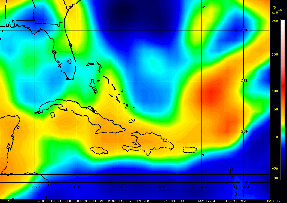
Vortmax1 wrote:Nice 200mb presentation of that TUTT low Hurakan!


Yes its supposed to slide west faster then 97L... I guess we will just have to wait and see how it plays out
0 likes   

User avatar
TeamPlayersBlue
Category 5
Category 5
Posts: 3445
Joined: Tue Feb 02, 2010 1:44 am
Location: Denver/Applewood, CO

Re: Re:

#1012 Postby TeamPlayersBlue » Wed Jul 21, 2010 12:58 pm

blp wrote:
x-y-no wrote:I think it stays at 60%.

...

Just for fun, I went back and looked at some of the discussion of the disturbance which eventually became Katrina.

It didn't look too great in this location either:


But note, even at that time the global models were quite hot on developing it in the Gulf ... so the parallel is actually not that good.


Thanks for showing that graphic.

\
i believe katrina was much further west and north when it developed. Between the Bahamas and FL
0 likes   
Personal Forecast Disclaimer:
The posts in this forum are NOT official forecast and should not be used as such. They are just the opinion of the poster and may or may not be backed by sound meteorological data. They are NOT endorsed by any professional institution or storm2k.org. For official information, please refer to the NHC and NWS products.

User avatar
KWT
Category 5
Category 5
Posts: 31415
Joined: Tue Aug 17, 2004 11:02 am
Location: UK!!!

#1013 Postby KWT » Wed Jul 21, 2010 12:58 pm

ULL tend to be really poorly modelled by the jmodels, I can't remember the amount of times they've busted...

Looks like this ULL though is a long term issue this season...
0 likes   
Personal Forecast Disclaimer:
The posts in this forum are NOT official forecast and should not be used as such. They are just the opinion of the poster and may or may not be backed by sound meteorological data. They are NOT endorsed by any professional institution or storm2k.org. For official information, please refer to the NHC and NWS products

tolakram
Admin
Admin
Posts: 20010
Age: 62
Joined: Sun Aug 27, 2006 8:23 pm
Location: Florence, KY (name is Mark)

Re: ATL: INVEST 97L - DISCUSSION

#1014 Postby tolakram » Wed Jul 21, 2010 12:58 pm

Speed this loop up and observe what many of us are identifying as a weak LLC.

http://wwwghcc.msfc.nasa.gov/cgi-bin/ge ... mframes=30

It's there, and looks to be low level, though not very big. Slowly but surely the inflow is getting established.
0 likes   
M a r k
- - - - -
Join us in chat: Storm2K Chatroom Invite. Android and IOS apps also available.

The posts in this forum are NOT official forecasts and should not be used as such. Posts are NOT endorsed by any professional institution or STORM2K.org. For official information and forecasts, please refer to NHC and NWS products.

User avatar
Blown Away
S2K Supporter
S2K Supporter
Posts: 10147
Joined: Wed May 26, 2004 6:17 am

Re: ATL: INVEST 97L - DISCUSSION

#1015 Postby Blown Away » Wed Jul 21, 2010 12:58 pm

Looking at the IR is the convection in the NW Caribbean enhancing 97L?
http://www.ssd.noaa.gov/goes/east/tatl/loop-avn.html
0 likes   
Hurricane Eye Experience: David 79, Irene 99, Frances 04, Jeanne 04, Wilma 05... EYE COMING MY WAY IN 2024…
Hurricane Brush Experience: Andrew 92, Erin 95, Floyd 99, Matthew 16, Irma 17, Ian 22, Nicole 22…

User avatar
fci
S2K Supporter
S2K Supporter
Posts: 3324
Joined: Tue Sep 14, 2004 10:29 am
Location: Lake Worth, FL

Re: ATL: INVEST 97L - DISCUSSION

#1016 Postby fci » Wed Jul 21, 2010 12:58 pm

Steve wrote:For the Joe B fans, he put out a free video today (see link below). He's not worried about anything beyond South Florida but thinks the leftover moisture (south of Hispanola) and the next wave coming through could spell trouble for the Gulf next week (168ish hours).

http://www.accuweather.com/video/731462 ... e-gulf.asp


I'm not a JB fan, at least not over any other Pro Met; but thank you for posting the link; a very good analysis was presented.
0 likes   

User avatar
x-y-no
Category 5
Category 5
Posts: 8359
Age: 65
Joined: Wed Aug 11, 2004 12:14 pm
Location: Fort Lauderdale, FL

Re: Re:

#1017 Postby x-y-no » Wed Jul 21, 2010 12:59 pm

TeamPlayersBlue wrote:i believe katrina was much further west and north when it developed. Between the Bahamas and FL


When she got named, yes. But TD 12 formed near Long Cay in the SE Bahamas, if I recall correctly.
0 likes   

StormClouds63
Category 2
Category 2
Posts: 583
Age: 62
Joined: Tue May 13, 2008 11:56 am
Location: Southwest Louisiana

Re:

#1018 Postby StormClouds63 » Wed Jul 21, 2010 1:00 pm

Weatherfreak000 wrote:That ULL is certainly a bad omen.


A tropical depression may be the most which can be expected out of this system unless the upper air patterns change. As long as the ULL continues moving west and produces shear, little chance of any significant or rapid intensification.
0 likes   

tolakram
Admin
Admin
Posts: 20010
Age: 62
Joined: Sun Aug 27, 2006 8:23 pm
Location: Florence, KY (name is Mark)

Re: ATL: INVEST 97L - DISCUSSION

#1019 Postby tolakram » Wed Jul 21, 2010 1:02 pm

Image
0 likes   
M a r k
- - - - -
Join us in chat: Storm2K Chatroom Invite. Android and IOS apps also available.

The posts in this forum are NOT official forecasts and should not be used as such. Posts are NOT endorsed by any professional institution or STORM2K.org. For official information and forecasts, please refer to NHC and NWS products.

User avatar
BigA
Professional-Met
Professional-Met
Posts: 1317
Joined: Sun Jul 24, 2005 10:56 pm

Re: ATL: INVEST 97L - DISCUSSION

#1020 Postby BigA » Wed Jul 21, 2010 1:04 pm

From what I can tell, the reason that the models forecast a reduction in shear is not due to a forecast weakening of the ULL, but that the ULL is forecast to skedaddle westward faster than 97L. Each of the 4 models that I've seen shows this (CMC, WRF, NOGAPS,GFS). But someone mentioned that the models often poorly forecast ULLs
0 likes   


Return to “2010”

Who is online

Users browsing this forum: No registered users and 7 guests