ATL: MATTHEW - Ex-Tropical Storm - Discussion

Moderator: S2k Moderators

Message
Author
User avatar
canes101
Tropical Storm
Tropical Storm
Posts: 122
Joined: Mon Jun 14, 2010 7:00 am

Re:

#1121 Postby canes101 » Fri Sep 24, 2010 7:25 pm

Vortmax1 wrote:
Thank you Vortmax. Do you know if any of the models pick it back up for potential regen?


Please read the NHC discussion at 5 PM:


FOR THE PAST FEW DAYS GLOBAL MODELS HAVE BEEN CONSISTENTLY DEPICTING
A TROPICAL CYCLONE IN THE NORTHWESTERN CARIBBEAN SEA TOWARD THE
MIDDLE OF NEXT WEEK. THE MOST RECENT RUNS INDICATE THAT ANY
DEVELOPMENT THERE WOULD LIKELY NOT HAVE CONTINUITY WITH MATTHEW...
BUT RATHER REPRESENT THE FORMATION A NEW TROPICAL CYCLONE.


Very interesting.. Thank you and I'm sorry.....
0 likes   
2010 Archive: HURRICANE ALEX, TD TWO, TS BONNIE, TS COLIN, TD FIVE, HURRICANE DANIELLE, HURRICANE EARL, TS FIONA, TS GASTON, TS HERMINE, HURRICANE IGOR, HURRICANE JULIA, HURRICANE KARL, HURRICANE LISA, TS MATTHEW, TS NICOLE, HURRICANE OTTO, HURRICANE PAULA (Active)

User avatar
FLpanhandle91
Category 4
Category 4
Posts: 956
Age: 33
Joined: Mon Sep 13, 2010 3:50 pm
Location: Fort Walton Beach, FL

Re: ATL: MATTHEW - Tropical Storm - Discussion

#1122 Postby FLpanhandle91 » Fri Sep 24, 2010 8:02 pm

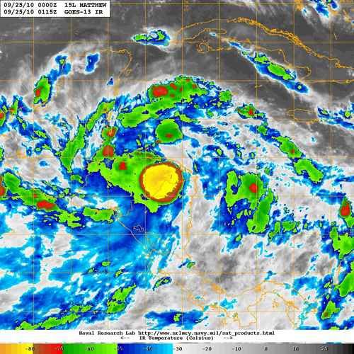
Huge blowup of convection near the center. wow.
0 likes   
Global model run times (CST):
GFS - 0z: 10:30pm, 6z: 4:30am, 12z: 10:30am, 18z: 4:30pm Euro - 0z: 12:30am 12z: 12:30pm

User avatar
HURAKAN
Professional-Met
Professional-Met
Posts: 46086
Age: 37
Joined: Thu May 20, 2004 4:34 pm
Location: Key West, FL
Contact:

#1123 Postby HURAKAN » Fri Sep 24, 2010 8:02 pm

AL, 15, 2010092500, , BEST, 0, 150N, 843W, 50, 998, TS

stronger now?
0 likes   

CrazyC83
Professional-Met
Professional-Met
Posts: 33393
Joined: Tue Mar 07, 2006 11:57 pm
Location: Deep South, for the first time!

#1124 Postby CrazyC83 » Fri Sep 24, 2010 8:12 pm

Looks to be back over water maybe? Or underestimated at landfall?
0 likes   

User avatar
sfwx
Category 1
Category 1
Posts: 371
Age: 58
Joined: Thu Sep 04, 2003 1:53 pm
Location: Rural St. Lucie County, Fl

Re: ATL: MATTHEW - Tropical Storm - Discussion

#1125 Postby sfwx » Fri Sep 24, 2010 8:20 pm

Accuweather forecast for my area. That would be an early cool front for Florida! Seems so much like Wilma...

Thursday Sep 30
Windy with t-storms possible 89°Lo 75°

Friday Oct 1
Very windy; a t-storm or two 89°Lo 81°

Saturday Oct 2
Windy with rain and a t-storm 91°Lo 59

Sunday Oct 3
Mostly cloudy; windy, cooler 77°Lo 60°
0 likes   

cpdaman
Category 5
Category 5
Posts: 3131
Joined: Sat Jun 10, 2006 11:44 am
Location: SPB county (gulf stream)

Re: ATL: MATTHEW - Tropical Storm - Discussion

#1126 Postby cpdaman » Fri Sep 24, 2010 8:30 pm

sfwx wrote:Accuweather forecast for my area. That would be an early cool front for Florida! Seems so much like Wilma...

.....

Sunday Oct 3
Mostly cloudy; windy, cooler 77°Lo 60°


c'mon now. let's not get crazy . actually i would be a tad bit surprised if that cold front in the long range does materialize.......it's still early and that would certainly require quite the pattern change
0 likes   

User avatar
Normandy
Category 5
Category 5
Posts: 2293
Joined: Sun Oct 10, 2004 12:31 am
Location: Houston, TX

#1127 Postby Normandy » Fri Sep 24, 2010 8:36 pm

Latest IR is pretty sobering for Honduras from a rainfall perspective. Talk about explosive convection.
0 likes   

Florida1118
Category 5
Category 5
Posts: 1805
Age: 27
Joined: Sat Jun 19, 2010 12:57 pm
Location: Tampa, Florida

Re: ATL: MATTHEW - Tropical Storm - Discussion

#1128 Postby Florida1118 » Fri Sep 24, 2010 8:41 pm

sfwx wrote:Accuweather forecast for my area. That would be an early cool front for Florida! Seems so much like Wilma...

Thursday Sep 30
Windy with t-storms possible 89°Lo 75°

Friday Oct 1
Very windy; a t-storm or two 89°Lo 81°

Saturday Oct 2
Windy with rain and a t-storm 91°Lo 59

Sunday Oct 3
Mostly cloudy; windy, cooler 77°Lo 60°

We are discussing it in the NW Caribbean thread in Talkin Tropics...My local mets/accuweather are both confident we will see TS/H conditions, but it seems to be from Nicole not Matt.
0 likes   

User avatar
ConvergenceZone
Category 5
Category 5
Posts: 4833
Joined: Fri Jul 29, 2005 1:40 am
Location: Northern California

#1129 Postby ConvergenceZone » Fri Sep 24, 2010 8:43 pm

Well, I think we may have to wait for another couple of weeks after Matthew dies off to get anything going...I don't see any waves/pouches being tracked. No other invests, and usually we know about them a few days before they pop up. So we should all get a much deserved break after Matthew.

In my opinion, I think the models will gradually back down from developing Nicole due to Matthew's change of track today.
0 likes   

User avatar
srainhoutx
S2K Supporter
S2K Supporter
Posts: 6919
Age: 66
Joined: Sun Jan 14, 2007 11:34 am
Location: Haywood County, NC
Contact:

Re:

#1130 Postby srainhoutx » Fri Sep 24, 2010 8:44 pm

Normandy wrote:Latest IR is pretty sobering for Honduras from a rainfall perspective. Talk about explosive convection.


Image
0 likes   
Carla/Alicia/Jerry(In The Eye)/Michelle/Charley/Ivan/Dennis/Katrina/Rita/Wilma/Ike/Harvey

Member: National Weather Association
Wx Infinity Forums
http://wxinfinity.com/index.php

Facebook.com/WeatherInfinity
Twitter @WeatherInfinity

User avatar
Ptarmigan
Category 5
Category 5
Posts: 5273
Joined: Wed Aug 16, 2006 9:06 pm

Re:

#1131 Postby Ptarmigan » Fri Sep 24, 2010 8:56 pm

Normandy wrote:Latest IR is pretty sobering for Honduras from a rainfall perspective. Talk about explosive convection.


Looks to be a flooding disaster from it. Hope everyone is okay.
0 likes   

User avatar
HURAKAN
Professional-Met
Professional-Met
Posts: 46086
Age: 37
Joined: Thu May 20, 2004 4:34 pm
Location: Key West, FL
Contact:

#1132 Postby HURAKAN » Fri Sep 24, 2010 9:21 pm

Image

Latest
0 likes   

User avatar
CourierPR
Category 5
Category 5
Posts: 1325
Age: 70
Joined: Tue Aug 31, 2004 7:53 pm
Location: Pompano Beach, Florida

Re:

#1133 Postby CourierPR » Fri Sep 24, 2010 9:23 pm

ConvergenceZone wrote:Well, I think we may have to wait for another couple of weeks after Matthew dies off to get anything going...I don't see any waves/pouches being tracked. No other invests, and usually we know about them a few days before they pop up. So we should all get a much deserved break after Matthew.

In my opinion, I think the models will gradually back down from developing Nicole due to Matthew's change of track today.
Are you serious?! Have you read any of the posts in the NW Caribbean thread concerning what the models are developing next week?! :eek:
0 likes   

User avatar
KatDaddy
Category 5
Category 5
Posts: 2815
Joined: Mon Oct 21, 2002 6:23 pm
Location: League City, Texas

Re: ATL: MATTHEW - Tropical Storm - Discussion

#1134 Postby KatDaddy » Fri Sep 24, 2010 9:25 pm

Convective bomb has exploded over E Nicaragua and extreme N Honduras. A massive disaster is unfolding this evening
0 likes   
The following post is NOT an official forecast and should not be used as such. It is just the opinion of the poster and may or may not be backed by sound meteorological data. It is NOT endorsed by any professional institution including storm2k.org For Official Information please refer to the NHC and NWS products.

User avatar
Tropics Guy
Tropical Storm
Tropical Storm
Posts: 166
Age: 61
Joined: Tue Aug 31, 2004 8:12 pm
Location: Vero Beach, FL

Re: ATL: MATTHEW - Tropical Storm - Discussion

#1135 Postby Tropics Guy » Fri Sep 24, 2010 9:30 pm

Matt not dead yet, major convection bombing out over land...............

http://www.ssd.noaa.gov/goes/flt/t1/loop-avn.html

TG
0 likes   

User avatar
TwisterFanatic
Category 5
Category 5
Posts: 1041
Joined: Mon Jun 28, 2010 12:43 pm
Location: Sallisaw, Oklahoma

#1136 Postby TwisterFanatic » Fri Sep 24, 2010 9:34 pm

That part of the terrain is pretty flat right? Or am i mistaken.
0 likes   
Personal Forecast Disclaimer:
The posts in this forum are NOT official forecast and should not be used as such. They are just the opinion of the poster and may or may not be backed by sound meteorological data. They are NOT endorsed by any professional institution or storm2k.org. For official information, please refer to the NHC and NWS products.

User avatar
Tropics Guy
Tropical Storm
Tropical Storm
Posts: 166
Age: 61
Joined: Tue Aug 31, 2004 8:12 pm
Location: Vero Beach, FL

Re:

#1137 Postby Tropics Guy » Fri Sep 24, 2010 9:38 pm

TwisterFanatic wrote:That part of the terrain is pretty flat right? Or am i mistaken.


That part is relatively flat, if he continues west it will become increasingly higher terrain, if he jogs wnw towards Belize or Yucatan then it will stay relatively flat........


TG
0 likes   

User avatar
srainhoutx
S2K Supporter
S2K Supporter
Posts: 6919
Age: 66
Joined: Sun Jan 14, 2007 11:34 am
Location: Haywood County, NC
Contact:

Re: ATL: MATTHEW - Tropical Storm - Discussion

#1138 Postby srainhoutx » Fri Sep 24, 2010 9:44 pm

Image
0 likes   
Carla/Alicia/Jerry(In The Eye)/Michelle/Charley/Ivan/Dennis/Katrina/Rita/Wilma/Ike/Harvey

Member: National Weather Association
Wx Infinity Forums
http://wxinfinity.com/index.php

Facebook.com/WeatherInfinity
Twitter @WeatherInfinity

Florida1118
Category 5
Category 5
Posts: 1805
Age: 27
Joined: Sat Jun 19, 2010 12:57 pm
Location: Tampa, Florida

Re: ATL: MATTHEW - Tropical Storm - Discussion

#1139 Postby Florida1118 » Fri Sep 24, 2010 9:53 pm

Very strange on the track...Expect it to be post tropical then tropical again while still over land...
Image
Last edited by Florida1118 on Fri Sep 24, 2010 9:54 pm, edited 1 time in total.
0 likes   

User avatar
cjrciadt
S2K Supporter
S2K Supporter
Posts: 1615
Joined: Mon Aug 22, 2005 1:11 pm
Location: Kissimmee, FL

Re: ATL: MATTHEW - Tropical Storm - Discussion

#1140 Postby cjrciadt » Fri Sep 24, 2010 9:53 pm

amamzing cold cloud tops, over land!!!
0 likes   


Return to “2010”

Who is online

Users browsing this forum: No registered users and 7 guests