
ATL: EX-Tropical Depression FIVE - Discussion
Moderator: S2k Moderators
-
chzzdekr81

- S2K Supporter

- Posts: 189
- Joined: Sun Aug 30, 2009 7:54 pm
- Location: Orange, Texas (SETX)
- Contact:


Re:
Aric Dunn wrote:another tornado warning over florida.. even a weak pointless TD can cause issues... have not heard of any major damage but none the less its a reason why all tropical systems are not irrelevant
I'm in Winter Park (Central FL) and yes... 3 funnel clouds reported in the last 20 minutes. Under Warning for another half-hour.
0 likes

Call me crazy (it wouldn't be the first time today), but the system has become a little better organized this afternoon...the center seems to have reformed right off the Florida Panhandle coast, and has started to produce some heavy convection. Perhaps one last gasp is in progress? If the system moves far enough west (I'm on Dauphin Island), I'll provide some "eye of the storm" reports!

Last edited by rockyman on Wed Aug 11, 2010 4:28 pm, edited 1 time in total.
0 likes

>>It actually looks like what you are referring to is moving due west....crazy tropics.
Absolutely. And that's why we're here. I know people get hung up on some of the wimpier storms, but they're still cool to track and watch. They're almost always throwing you some kind of curve-ball to help you file something away in your memory banks to use again some day trying to understand things. Turns out several of the models may have done quite well at differing times with the system. Most (except dynamics) never got it strong but took the center, following the upper low, toward the NC Gulf. Some progged tightening near the coast. Some have suggested a stall or whatever. It's the same thing with Bonnie's remnants. I was drinking beer on my swing on my porch between 3-5am and it was a lot more potent than it looked on IR. Been pretty near some hurricanes that had far less effect (Elena for instance). Hell, we've seen two inches already from #5 and probably will see a couple more inches overnight. Not bad for a wimpy system.
Absolutely. And that's why we're here. I know people get hung up on some of the wimpier storms, but they're still cool to track and watch. They're almost always throwing you some kind of curve-ball to help you file something away in your memory banks to use again some day trying to understand things. Turns out several of the models may have done quite well at differing times with the system. Most (except dynamics) never got it strong but took the center, following the upper low, toward the NC Gulf. Some progged tightening near the coast. Some have suggested a stall or whatever. It's the same thing with Bonnie's remnants. I was drinking beer on my swing on my porch between 3-5am and it was a lot more potent than it looked on IR. Been pretty near some hurricanes that had far less effect (Elena for instance). Hell, we've seen two inches already from #5 and probably will see a couple more inches overnight. Not bad for a wimpy system.
0 likes
-
tolakram
- Admin

- Posts: 20186
- Age: 62
- Joined: Sun Aug 27, 2006 8:23 pm
- Location: Florence, KY (name is Mark)
Re: ATL: Tropical Depression FIVE - Discussion
Just like a storm to develop once it's written off. 2010 is the year of opposites, so far.
Buoys.
http://www.ndbc.noaa.gov/maps/Florida.shtml
42039

42040
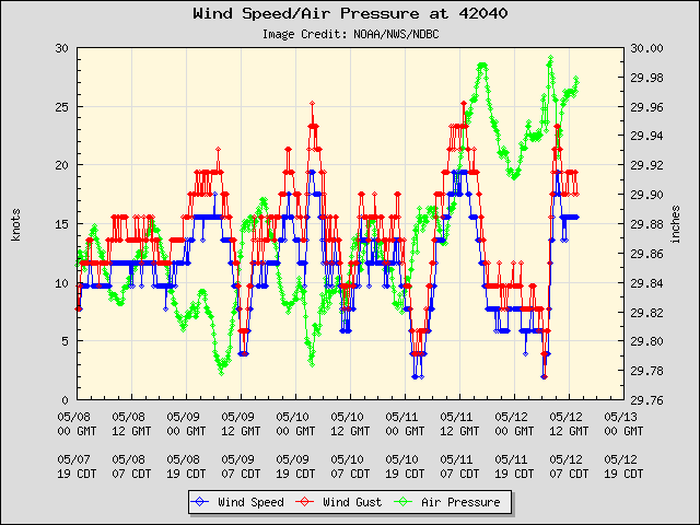
Loop: http://wwwghcc.msfc.nasa.gov/cgi-bin/ge ... mframes=15
Not enough time left, but looks to finally be consolidating.
Buoys.
http://www.ndbc.noaa.gov/maps/Florida.shtml
42039
42040
Loop: http://wwwghcc.msfc.nasa.gov/cgi-bin/ge ... mframes=15
Not enough time left, but looks to finally be consolidating.
0 likes
M a r k
- - - - -
Join us in chat: Storm2K Chatroom Invite. Android and IOS apps also available.
The posts in this forum are NOT official forecasts and should not be used as such. Posts are NOT endorsed by any professional institution or STORM2K.org. For official information and forecasts, please refer to NHC and NWS products.
-
chzzdekr81
- S2K Supporter
- Posts: 189
- Joined: Sun Aug 30, 2009 7:54 pm
- Location: Orange, Texas (SETX)
- Contact:
Re:
rockyman wrote:Call me crazy (it wouldn't be the first time today), but the system has become a little better organized this afternoon...the center seems to have reformed right off the Florida Panhandle coast, and has started to produce some heavy convection. Perhaps one last gasp is in progress? If the system moves far enough west (I'm on Dauphin Island), I'll provide some "eye of the storm" reports!
That would be crazy...
0 likes
I survived Rita, Humberto, Edouard, and Ike.


Re:
rockyman wrote:Call me crazy (it wouldn't be the first time today), but the system has become a little better organized this afternoon...the center seems to have reformed right off the Florida Panhandle coast, and has started to produce some heavy convection. Perhaps one last gasp is in progress? If the system moves far enough west (I'm on Dauphin Island), I'll provide some "eye of the storm" reports!
I hope you are wrong but if that is the case I will be providing some pics from the other side of the bay.
0 likes
-
petit_bois

- Tropical Storm

- Posts: 227
- Joined: Tue Jun 22, 2010 12:04 pm
- Location: Petit Bois Island Mississippi
Re: Re:
shell70 wrote:rockyman wrote:Call me crazy (it wouldn't be the first time today), but the system has become a little better organized this afternoon...the center seems to have reformed right off the Florida Panhandle coast, and has started to produce some heavy convection. Perhaps one last gasp is in progress? If the system moves far enough west (I'm on Dauphin Island), I'll provide some "eye of the storm" reports!
I hope you are wrong but if that is the case I will be providing some pics from the other side of the bay.
I'm on Petit Bois
0 likes
Resident of the Atlantic Basin's Major Hurricane Hit Capital!
Camille (200+winds), Frederic, Goerges, Katrina... and many many more.
Disclaimer: I'm likely the smartest guy here... but I have no idea where a tropical cyclone will go. I suggest you take my opinion as a grain of salt. I suggest you look to the National Hurricane Center for accurate info.
Camille (200+winds), Frederic, Goerges, Katrina... and many many more.
Disclaimer: I'm likely the smartest guy here... but I have no idea where a tropical cyclone will go. I suggest you take my opinion as a grain of salt. I suggest you look to the National Hurricane Center for accurate info.

Another case of how politics and legaleze has corrupted even weather forcasting. This would have never been given a TD title IMO if it was not for the close proxemity to land and they were not sure if it would develop or not. Better to name a swirl a TD than to have it develop just before moving inland and have the media screaming about an un-forcasted storm hitting somewhere.
It's really pathetic, and it causes all kinds of problems. The public panics, buys everything in sight, and nothing but a thunderstorm hits them. When a real storm comes, they dont evacuate/prepare/listen because they think they have been through a real tropical system.
My opinion anyhow....
It's really pathetic, and it causes all kinds of problems. The public panics, buys everything in sight, and nothing but a thunderstorm hits them. When a real storm comes, they dont evacuate/prepare/listen because they think they have been through a real tropical system.
My opinion anyhow....
0 likes
Ginger-(eye),Dennis,Diana,Kate,Gloria,Charley-(eye),Allison,Arthur,Bertha,Fran,Josephine,Bonnie,Earl,Dennis-(twice),Floyd, Isabel-(eye),Charley,Ophelia-(eyewall),Ernesto,Barry,Hanna,Irene-(eye),Arthur-(eye), Florence, Dorian, and countless depressions, storms, and nor'easters.
-
Stormcenter
- S2K Supporter
- Posts: 6689
- Joined: Wed Sep 03, 2003 11:27 am
- Location: Houston, TX
Re:
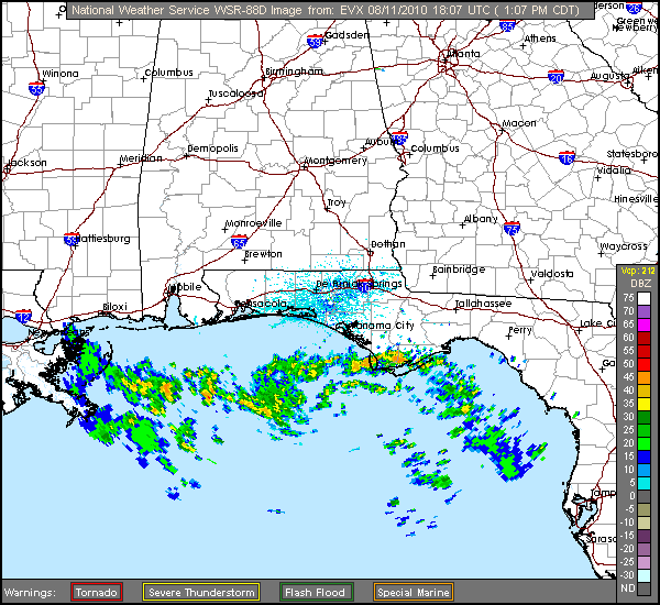
The "mean" center you are referring to looks like it's not moving at all.
Aric Dunn wrote:Its just an eddy at the moment there is another eddy farther to the SW both circulating around the "mean" center that is not moving very fast.
0 likes
http://radar.weather.gov/radar.php?prod ... x&loop=yes
Nice little train on the way. I was going to go home and go to sleep since I've been out late the last couple of days with Madden Gras (Galactic Concert and Deuce, Marcus Allen, Marshall Faulk, Joe Horn, Jackson, McKenzie etc. riding in the parade) and then the City Cup Dart Championship last night. But I might just have to stop on the way home to pick up a 6-pack to party with the remnants of TD #5.
Nice little train on the way. I was going to go home and go to sleep since I've been out late the last couple of days with Madden Gras (Galactic Concert and Deuce, Marcus Allen, Marshall Faulk, Joe Horn, Jackson, McKenzie etc. riding in the parade) and then the City Cup Dart Championship last night. But I might just have to stop on the way home to pick up a 6-pack to party with the remnants of TD #5.
Last edited by Steve on Wed Aug 11, 2010 4:35 pm, edited 1 time in total.
0 likes
-
Florida1118
Re:
capepoint wrote:Another case of how politics and legaleze has corrupted even weather forcasting. This would have never been given a TD title IMO if it was not for the close proxemity to land and they were not sure if it would develop or not. Better to name a swirl a TD than to have it develop just before moving inland and have the media screaming about an un-forcasted storm hitting somewhere.
It's really pathetic, and it causes all kinds of problems. The public panics, buys everything in sight, and nothing but a thunderstorm hits them. When a real storm comes, they dont evacuate/prepare/listen because they think they have been through a real tropical system.
My opinion anyhow....
I dont think The NHC plays alot of politics, but yet they found a TD, Issued warnings, it died unexpectedly, and stopped. They had all the Evidence to name it a TD.
0 likes
-
petit_bois
- Tropical Storm
- Posts: 227
- Joined: Tue Jun 22, 2010 12:04 pm
- Location: Petit Bois Island Mississippi
Re: ATL: Tropical Depression FIVE - Discussion
we are still under a ts warning here on Petit Bois as of 4pm... hmmm
0 likes
Resident of the Atlantic Basin's Major Hurricane Hit Capital!
Camille (200+winds), Frederic, Goerges, Katrina... and many many more.
Disclaimer: I'm likely the smartest guy here... but I have no idea where a tropical cyclone will go. I suggest you take my opinion as a grain of salt. I suggest you look to the National Hurricane Center for accurate info.
Camille (200+winds), Frederic, Goerges, Katrina... and many many more.
Disclaimer: I'm likely the smartest guy here... but I have no idea where a tropical cyclone will go. I suggest you take my opinion as a grain of salt. I suggest you look to the National Hurricane Center for accurate info.
I live on Dauphin Island, and I didn't see ANYONE "panic" or "buy everything in sight". I was at the grocery store in Mobile earlier today and saw no panic buying. I do not know of ANYONE who would think they had been through a "real tropical system" today. We coastal residents are a lot smarter than you give us credit for... As far as the NHC, they named this a depression, because it WAS a depression. Plain and simple.
0 likes
-
HURAKAN

- Professional-Met

- Posts: 46084
- Age: 39
- Joined: Thu May 20, 2004 4:34 pm
- Location: Key West, FL
- Contact:
Re: ATL: Tropical Depression FIVE - Discussion
petit_bois wrote:we are still under a ts warning here on Petit Bois as of 4pm... hmmm
WATCHES AND WARNINGS
--------------------
CHANGES WITH THIS ADVISORY...
THE TROPICAL STORM WARNING ALONG THE NORTHERN GULF COAST HAS BEEN
DISCONTINUED.
SUMMARY OF WATCHES AND WARNINGS IN EFFECT...
THERE ARE NO COASTAL WATCHES OR WARNINGS IN EFFECT.
0 likes
Re: Re:
petit_bois wrote:shell70 wrote:rockyman wrote:Call me crazy (it wouldn't be the first time today), but the system has become a little better organized this afternoon...the center seems to have reformed right off the Florida Panhandle coast, and has started to produce some heavy convection. Perhaps one last gasp is in progress? If the system moves far enough west (I'm on Dauphin Island), I'll provide some "eye of the storm" reports!
I hope you are wrong but if that is the case I will be providing some pics from the other side of the bay.
I'm on Petit Bois
I am on the other side of Mobile Bay to the East. The clouds have rolled but that is about all.
0 likes
-
lrak

- S2K Supporter
- Posts: 1770
- Age: 59
- Joined: Thu Jun 21, 2007 2:48 pm
- Location: Corpus Christi, TX
Re: ATL: Tropical Depression FIVE - Discussion
dang surf nazis! poof again...grr
0 likes
AKA karl
Also
Personal Forecast Disclaimer:
My posts on this forum are NOT official forecast and should not be used as such. My posts are my basic observations and are definitely not backed by any "well some" meteorological knowledge. For official information, please refer to the NHC and NWS products.
Also
Personal Forecast Disclaimer:
My posts on this forum are NOT official forecast and should not be used as such. My posts are my basic observations and are definitely not backed by any "well some" meteorological knowledge. For official information, please refer to the NHC and NWS products.
Who is online
Users browsing this forum: No registered users and 49 guests