ARABIAN SEA - DEEP DEPRESSION (03A)
Moderator: S2k Moderators


Re: ARABIAN SEA - CYCLONIC STORM PHET (03A)
TROPICAL CYCLONE ADVISORY
RSMC – TROPICAL CYCLONES, NEW DELHI
TROPICAL STORM ‘PHET’ ADVISORY NO. FOUR ISSUED AT 2000 UTC OF 01 JUNE 2010 BASED ON 1800 UTC CHARTS OF 01 JUNE.
THE CYCLONIC STORM, “PHET” OVER WESTCENTRAL & ADJOINING EASTCENTRAL ARABIAN SEA MOVED NORTHWESTWARD AND LAY CENTRED AT 1800 UTC OF 01ST JUNE 2010 NEAR LATITUDE 17.00N AND LONG. 62.00E, ABOUT 1200 KM WEST-SOUTHWEST OF MUMBAI(43003), 1000 KM SOUTHWEST OF NALIYA(42631) AND 1000 KM SOUTH-SOUTHWEST OF KARACHI(41781).
SUSTAINED MAXIMUM SURFACE WIND SPEED IS ESTIMATED TO BE ABOUT 45 KNOTS. THE STATE OF THE SEA IS HIGH TO VERY HIGH AROUND THE SYSTEM CENTRE. THE ESTIMATED CENTRAL PRESSURE IS ABOUT 990 HPA.
SATELLITE IMAGERY INDICATES CENTRAL DENSE OVERCAST PATTERN. THE INTENSITY OF THE SYSTEM IS T3.0. ASSOCIATED BROKEN INTENSE TO VERY INTENSE CONVECTION OBSERVED OVER AREA BETWEEN LAT. 12.50 N TO 19.00 N AND LONG. 56.00 TO 64.00 E. THE LOWEST CLOUD TOP TEMPERATURE (CTT) DUE TO CONVECTION IS BETWEEN -700C TO -800C IN ASSOCIATION WITH THE SYSTEM.
VERTICAL WIND SHEAR OF HORIZONTAL WIND OVER THE REGION IS BETWEEN 05-15 KNOTS. THE SYSTEM LIES TO THE SOUTH OF TROPOSPHERIC RIDGE, WHICH ROUGHLY RUNS ALONG 20.00 N OVER THE REGION. THE RELATIVE VORTICITY AT 850 HPA LEVEL AND UPPER LEVEL DIVERGENCE ARE ALSO FAVOURABLE FOR FURTHER INTENSIFICATION.
THE CURRENT ENVIRONMENTAL CONDITIONS AND NUMERICAL WEATHER PREDICTION MODELS SUGGEST THAT THE SYSTEM WOULD INTENSIFY INTO A SEVERE CYCLONIC STORM AND MOVE SLOWLY IN A NORTH-NORTHWESTERLY/NORTHERLY DIRECTION FOR NEXT 24 HOURS AND THEN RECURVE NORTHEASTWARDS TOWARDS GUJARAT & ADJOINING PAKISTAN COAST UNDER THE INFLUENCE OF THE APPROACHING TROUGH IN MID-LATITUDE WESTERLIES AT 500 HPA LEVEL. SQUALLY WINDS WITH SPEED REACHING 55-65 KMPH GUSTING TO 65 KMPH WOULD COMMENCE ALONG AND OFF OMAN COAST AS A PERIPHERAL AFFECT OF THE SYSTEM FROM AFTERNOON OF 2ND JUNE.
BASED ON LATEST ANALYSIS WITH NWP MODELS AND OTHER CONVENTIONAL TECHNIQUES, ESTIMATED TRACK AND INTENSITY OF THE SYSTEM ARE GIVEN BELOW:
DATE/TIME(UTC)
POSITION (LAT. 0N/ LONG. 0E)
SUSTAINED MAXIMUM SURFACE WIND SPEED (KMPH)
01-06-2010/1800
17.0/62.0
75-85 GUSTING TO 95
02-06-2010/0000
17.5/62.0
75-85 GUSTING TO 95
02-06-2010/0600
18.0/62.0
85-95 GUSTING TO 105
02-06-2010/1200
18.5/62.0
95-105 GUSTING TO 115
02-06-2010/1800
19.0/62.5
105-115 GUSTING TO 125
03-06-2010/0000
20.0/63.0
115-125 GUSTING TO 135
03-06-2010/1200
21.5/65.0
125-135 GUSTING TO 150
04-06-2010/0000
22.5/67.0
125-135 GUSTING TO 150
04-06-.2010/1200
23.5/69.0
135-145 GUSTING TO 160
0 likes


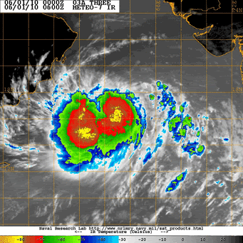
That eyewall really is wrapping around very well right now, thats a rather worrying development becuase that was open 9hrs ago on the western side.
0 likes
Personal Forecast Disclaimer:
The posts in this forum are NOT official forecast and should not be used as such. They are just the opinion of the poster and may or may not be backed by sound meteorological data. They are NOT endorsed by any professional institution or storm2k.org. For official information, please refer to the NHC and NWS products
The posts in this forum are NOT official forecast and should not be used as such. They are just the opinion of the poster and may or may not be backed by sound meteorological data. They are NOT endorsed by any professional institution or storm2k.org. For official information, please refer to the NHC and NWS products
-
cycloneye

- Admin

- Posts: 149585
- Age: 69
- Joined: Thu Oct 10, 2002 10:54 am
- Location: San Juan, Puerto Rico
Re: ARABIAN SEA - CYCLONIC STORM PHET (03A)
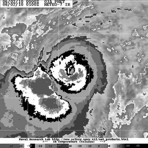
Here is the latest image.

0 likes
Visit the Caribbean-Central America Weather Thread where you can find at first post web cams,radars
and observations from Caribbean basin members Click Here
and observations from Caribbean basin members Click Here
Re: ARABIAN SEA - CYCLONIC STORM PHET (03A)
TROPICAL CYCLONE ADVISORY
RSMC – TROPICAL CYCLONES, NEW DELHI
TROPICAL STORM ‘PHET’ ADVISORY NO. FIVE ISSUED AT 0000 UTC OF 02 JUNE 2010 BASED ON 2100 UTC CHARTS OF 01 JUNE.
THE CYCLONIC STORM, “PHET” OVER WESTCENTRAL & ADJOINING EASTCENTRAL ARABIAN SEA REMAINED PRACTICALLY STATIONARY AND LAY CENTRED AT 2100 UTC OF 01ST JUNE 2010 NEAR LATITUDE 17.00N AND LONG. 62.00E, ABOUT 1200 KM WEST-SOUTHWEST OF MUMBAI(43003), 1000 KM SOUTHWEST OF NALIYA(42631) AND 1000 KM SOUTH-SOUTHWEST OF KARACHI(41781).
SUSTAINED MAXIMUM SURFACE WIND SPEED IS ESTIMATED TO BE ABOUT 45 KNOTS. THE STATE OF THE SEA IS HIGH TO VERY HIGH AROUND THE SYSTEM CENTRE. THE ESTIMATED CENTRAL PRESSURE IS ABOUT 990 HPA.
SATELLITE IMAGERY INDICATES CENTRAL DENSE OVERCAST PATTERN. THE INTENSITY OF THE SYSTEM IS T3.0. ASSOCIATED BROKEN INTENSE TO VERY INTENSE CONVECTION OBSERVED OVER AREA BETWEEN LAT. 12.50 N TO 19.00 N AND LONG. 56.00 TO 64.00 E. THE LOWEST CLOUD TOP TEMPERATURE (CTT) DUE TO CONVECTION IS BETWEEN -700C TO -800C IN ASSOCIATION WITH THE SYSTEM.
VERTICAL WIND SHEAR OF HORIZONTAL WIND OVER THE REGION IS BETWEEN 05-15 KNOTS. THE SYSTEM LIES TO THE SOUTH OF TROPOSPHERIC RIDGE, WHICH ROUGHLY RUNS ALONG 20.00 N OVER THE REGION. THE RELATIVE VORTICITY AT 850 HPA LEVEL AND UPPER LEVEL DIVERGENCE ARE ALSO FAVOURABLE FOR FURTHER INTENSIFICATION.
THE CURRENT ENVIRONMENTAL CONDITIONS AND NUMERICAL WEATHER PREDICTION MODELS SUGGEST THAT THE SYSTEM WOULD INTENSIFY INTO A SEVERE CYCLONIC STORM AND MOVE SLOWLY IN A NORTH-NORTHWESTERLY/NORTHERLY DIRECTION FOR NEXT 24 HOURS AND THEN RECURVE NORTHEASTWARDS TOWARDS GUJARAT & ADJOINING PAKISTAN COAST UNDER THE INFLUENCE OF THE APPROACHING TROUGH IN MID-LATITUDE WESTERLIES AT 500 HPA LEVEL. SQUALLY WINDS WITH SPEED REACHING 55-65 KMPH GUSTING TO 65 KMPH WOULD COMMENCE ALONG AND OFF OMAN COAST AS A PERIPHERAL AFFECT OF THE SYSTEM FROM AFTERNOON OF 2ND JUNE.
BASED ON LATEST ANALYSIS WITH NWP MODELS AND OTHER CONVENTIONAL TECHNIQUES, ESTIMATED TRACK AND INTENSITY OF THE SYSTEM ARE GIVEN BELOW:
Date/Time(IST)
Position (lat. 0N/ long. 0E)
Sustained maximum surface wind speed (kmph)
02-06-2010/2100
17.0/62.0
75-85 gusting to 95
02-06-2010/0000
17.5/62.0
75-85 gusting to 95
02-06-2010/0600
18.0/62.0
85-95 gusting to 105
02-06-2010/1200
18.5/62.0
95-105 gusting to 115
02-06-2010/1800
19.0/62.5
105-115 gusting to 125
03-06-2010/0000
20.0/63.0
115-125 gusting to 135
03-06-2010/1200
21.0/64.0
125-135 gusting to 150
04-06-2010/0000
22.0/66.0
125-135 gusting to 150
04-06-.2010/1200
23.0/68.0
135-145 gusting to 160
05-06-.2010/0000
24.0/70.0
95-105 gusting to 115
0 likes

Re: ARABIAN SEA - CYCLONIC STORM PHET (03A)
IMD New Delhi
ARB 02/2010/11 Dated: 02.06.2010
Time of issue: 0530 hours IST
Sub: Cyclonic storm, ‘PHET’ over westcentral & adjoining eastcentral Arabian Sea.
The cyclonic storm, “PHET” over westcentral & adjoining eastcentral Arabian Sea remained practically stationary and lay centred at 0230 hrs IST of 02nd June 2010 near latitude 17.00N and long. 62.00E, about 1200 km west-southwest of Mumbai, 1000 km southwest of Naliya (Kutch, Gujarat) and 1000 km southwest of Karachi (Pakistan)
The current environmental condition and Numerical Weather Prediction (NWP) models suggest that the system would intensify further into a severe cyclonic storm and move slowly in a north-northwesterly/northerly direction for next 24 hours and then recurve northeastwards towards Gujarat & adjoining Pakistan coast.
Based on latest analysis with NWP models and other conventional techniques, estimated track and intensity of the system are given below:
Date/Time(IST)
Position (lat. 0N/ long. 0E)
Sustained maximum surface wind speed (kmph)
02-06-2010/0230
17.0/62.0
75-85 gusting to 95
02-06-2010/0530
17.5/62.0
75-85 gusting to 95
02-06-2010/1130
18.0/62.0
85-95 gusting to 105
02-06-2010/1730
18.5/62.0
95-105 gusting to 115
02-06-2010/2330
19.0/62.5
105-115 gusting to 125
03-06-2010/0530
20.0/63.0
115-125 gusting to 135
03-06-2010/1730
21.0/64.0
125-135 gusting to 150
04-06-2010/0530
22.0/66.0
125-135 gusting to 150
04-06-.2010/1730
23.0/68.0
135-145 gusting to 160
05-06-.2010/0530
24.0/70.0
95-105 gusting to 115
Under the influence of this system, fairly widespread rainfall with isolated heavy to very heavy falls would commence over coastal areas of Gujarat from 4th June 2010 and increase thereafter. Squally winds with speed reaching 65-75 kmph gusting 85 kmph would commence along and off Gujarat coast from 3rd June 2010 and increase gradually.
Sea condition will be high to very high along and off Gujarat coast from 3rd June 2010. Fishermen are advised not venture into the sea.
Next bulletin will be issued at 0830 hrs IST of 02nd June 2010.
0 likes
-
Category 5

- Category 5

- Posts: 10074
- Age: 36
- Joined: Sun Feb 11, 2007 10:00 pm
- Location: New Brunswick, NJ
- Contact:
Re: ARABIAN SEA - CYCLONIC STORM PHET (03A)
Does IMD really have this at 45kts? I mean I'm not one to rip professional organizations but are there any actual mets working at IMD? I mean what the heck.
0 likes

"GAME SET MATCH GIANTS WILL WIN THE NFC EAST and have a FIRST ROUND BYE with a win next week!!!" - StormingB81, the Giants lost, and did not win the NFC east.
-
srainhoutx

- S2K Supporter

- Posts: 6919
- Age: 68
- Joined: Sun Jan 14, 2007 11:34 am
- Location: Haywood County, NC
- Contact:
Re: ARABIAN SEA - CYCLONIC STORM PHET (03A)
0 likes
Carla/Alicia/Jerry(In The Eye)/Michelle/Charley/Ivan/Dennis/Katrina/Rita/Wilma/Ike/Harvey
Member: National Weather Association
Wx Infinity Forums
http://wxinfinity.com/index.php
Facebook.com/WeatherInfinity
Twitter @WeatherInfinity
Member: National Weather Association
Wx Infinity Forums
http://wxinfinity.com/index.php
Facebook.com/WeatherInfinity
Twitter @WeatherInfinity
-
Grifforzer
- Category 1

- Posts: 418
- Joined: Thu Feb 26, 2009 11:27 pm
Re: ARABIAN SEA - CYCLONIC STORM PHET (03A)
Category 5 wrote:Does IMD really have this at 45kts? I mean I'm not one to rip professional organizations but are there any actual mets working at IMD? I mean what the heck.
not really.
They have the system at least 50-60 knots now. Just wait for the 0:00 AM UTC advisory to be released to see that they have increased the winds.
0 likes
-
Grifforzer
- Category 1
- Posts: 418
- Joined: Thu Feb 26, 2009 11:27 pm
ARABIAN SEA - SEVERE CYCLONIC STORM PHET (03A)
ARB02/2010/12 Dated: 02.06.2010
Time of issue: 0700 hours IST
Sub: Severe cyclonic storm, ‘PHET’ over westcentral & adjoining eastcentral Arabian Sea.
The cyclonic storm, “PHET” over westcentral & adjoining eastcentral Arabian Sea intensify further into a severe cyclonic storm and moved northwestward and lay centred at 0530 hrs IST of today, 02nd June 2010 near latitude 17.50N and long. 61.50E, about 1200 km west-southwest of Mumbai, 1000 km southwest of Naliya (Kutch, Gujarat) and 1000 km southwest of Karachi (Pakistan).
The current environmental condition and Numerical Weather Prediction (NWP) models suggest that the system would intensify further into a very severe cyclonic storm and move slowly in a north-northwesterly/northerly direction for next 24 hours and then recurve northeastwards towards Gujarat & adjoining Pakistan coast.
0 likes

-
CrazyC83
- Professional-Met

- Posts: 34315
- Joined: Tue Mar 07, 2006 11:57 pm
- Location: Deep South, for the first time!
UW - CIMSS
ADVANCED DVORAK TECHNIQUE
ADT-Version 8.1.1
Tropical Cyclone Intensity Algorithm
----- Current Analysis -----
Date : 02 JUN 2010 Time : 030000 UTC
Lat : 17:45:00 N Lon : 60:50:51 E
CI# /Pressure/ Vmax
5.7 / 935.4mb/107.2kt
Final T# Adj T# Raw T#
5.5 6.0 6.0
Latitude bias adjustment to MSLP : +0.0mb
Estimated radius of max. wind based on IR :N/A km
Center Temp : -42.0C Cloud Region Temp : -73.6C
Scene Type : EYE
Positioning Method : SPIRAL ANALYSIS
Ocean Basin : INDIAN
Dvorak CI > MSLP Conversion Used : PACIFIC
Tno/CI Rules : Constraint Limits : NO LIMIT
Weakening Flag : ON
Rapid Dissipation Flag : OFF
0 likes


Who is online
Users browsing this forum: No registered users and 46 guests