ATL: IGOR - Ex Hurricane - Discussion
Moderator: S2k Moderators
-
MGC

- S2K Supporter

- Posts: 5940
- Joined: Sun Mar 23, 2003 9:05 pm
- Location: Pass Christian MS, or what is left.
Re: ATL: Tropical Storm IGOR - Discussion
Well, Igor sprung to life a bit quicker than I thought.....must have gotten a considerable jolt of juice to reanimate his circulation.....lets see how far west he tracks....models nearly always want to recurve too fast......MGC
0 likes
-
ConvergenceZone
.gif)
- Category 5

- Posts: 5241
- Joined: Fri Jul 29, 2005 1:40 am
- Location: Northern California
-
cycloneye

- Admin

- Posts: 149472
- Age: 69
- Joined: Thu Oct 10, 2002 10:54 am
- Location: San Juan, Puerto Rico
Re: ATL: Tropical Storm IGOR - Discussion
Ok folks, lets return to the topic in hand and that is about IGOR, not about other members. Thanks for your cooperation.
0 likes
Visit the Caribbean-Central America Weather Thread where you can find at first post web cams,radars
and observations from Caribbean basin members Click Here
and observations from Caribbean basin members Click Here
-
ConvergenceZone
- Category 5
- Posts: 5241
- Joined: Fri Jul 29, 2005 1:40 am
- Location: Northern California
Re: ATL: Tropical Storm IGOR - Discussion
cycloneye wrote:Ok folks, lets return to the topic in hand and that is about IGOR, not about other members. Thanks for your cooperation.
yep, a 50% chance this will affect the USA down the line...
This can be really bad news down the road...
0 likes

-
SouthFLTropics

- Category 5
- Posts: 4258
- Age: 50
- Joined: Thu Aug 14, 2003 8:04 am
- Location: Port St. Lucie, Florida
Re: ATL: Tropical Storm IGOR - Discussion

SFT
0 likes
Fourth Generation Florida Native
Personal Storm History: David 79, Andrew 92, Erin 95, Floyd 99, Irene 99, Frances 04, Jeanne 04, Wilma 05, Matthew 16, Irma 17, Ian 22, Nicole 22, Milton 24
Personal Storm History: David 79, Andrew 92, Erin 95, Floyd 99, Irene 99, Frances 04, Jeanne 04, Wilma 05, Matthew 16, Irma 17, Ian 22, Nicole 22, Milton 24
-
mascpa
- S2K Supporter
- Posts: 500
- Age: 70
- Joined: Tue Sep 30, 2003 10:43 am
- Location: Jupiter, FL
- Contact:
Re: ATL: Tropical Storm IGOR - Discussion
Can someone please explain what ACE is, how it is computed, and what is the significance of the number? Thanks in advance.
0 likes
-
HURAKAN

- Professional-Met

- Posts: 46084
- Age: 39
- Joined: Thu May 20, 2004 4:34 pm
- Location: Key West, FL
- Contact:
Re: ATL: Tropical Storm IGOR - Discussion
mascpa wrote:Can someone please explain what ACE is, how it is computed, and what is the significance of the number? Thanks in advance.
Code: Select all
Accumulated cyclone energy (ACE) is a measure used by the National Oceanic and Atmospheric Administration (NOAA) to express the activity of individual tropical cyclones and entire tropical cyclone seasons, particularly the North Atlantic hurricane season. It uses an approximation of the energy used by a tropical system over its lifetime and is calculated every six-hour period. The ACE of a season is the sum of the ACEs for each storm and takes into account the number, strength, and duration of all the tropical storms in the season.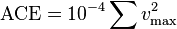
Link - http://en.wikipedia.org/wiki/Accumulated_cyclone_energy
0 likes
-
BatzVI

- Tropical Storm

- Posts: 199
- Joined: Sat Jun 10, 2006 8:27 am
- Location: St. Thomas, Virgin Islands
Re: ATL: Tropical Storm IGOR - Discussion
5. 1989's Hugo that devastated SC/NC
Please don't forget that this also devastated the Virgin Islands, namely St. Croix.
Please don't forget that this also devastated the Virgin Islands, namely St. Croix.
0 likes
-
TeamPlayersBlue

- Category 5
- Posts: 3530
- Joined: Tue Feb 02, 2010 1:44 am
- Location: Denver/Applewood, CO
Ok here we go, is this the storm some are afraid may enter the Gulf WAY out in the forecast?
0 likes
Personal Forecast Disclaimer:
The posts in this forum are NOT official forecast and should not be used as such. They are just the opinion of the poster and may or may not be backed by sound meteorological data. They are NOT endorsed by any professional institution or storm2k.org. For official information, please refer to the NHC and NWS products.
The posts in this forum are NOT official forecast and should not be used as such. They are just the opinion of the poster and may or may not be backed by sound meteorological data. They are NOT endorsed by any professional institution or storm2k.org. For official information, please refer to the NHC and NWS products.
-
DanKellFla

- Category 5
- Posts: 1291
- Joined: Fri Mar 17, 2006 12:02 pm
- Location: Lake Worth, Florida
-
cycloneye
- Admin
- Posts: 149472
- Age: 69
- Joined: Thu Oct 10, 2002 10:54 am
- Location: San Juan, Puerto Rico
Re: ATL: Tropical Storm IGOR - Discussion
mascpa wrote:Excellent reply, thanks!
To add some more about the ACE. If it gets over 150 units,this season will be considered a hyperactive one,word that was mentioned many times by the experts in their seasonal forecasts.
0 likes
Visit the Caribbean-Central America Weather Thread where you can find at first post web cams,radars
and observations from Caribbean basin members Click Here
and observations from Caribbean basin members Click Here
-
hurricaneCW
- Category 5
- Posts: 1799
- Joined: Wed Mar 03, 2010 6:20 am
- Location: Toms River, NJ
Re: ATL: Tropical Storm IGOR - Discussion
Although I'm 99% sure it will recurve, it should still be monitored, I mean the Cape Verde islands are already under the threat zone (very rare). Right now I'm guessing the point of recurvature will be similar to Danielle's or around 60-62W. This one could be a massive monster so you wouldn't want it getting any closer.
0 likes

Re: ATL: Tropical Storm IGOR - Discussion
Right over the Cape Verde Islands is a very high exit point for an African system.
0 likes
-
hurricaneCW
- Category 5
- Posts: 1799
- Joined: Wed Mar 03, 2010 6:20 am
- Location: Toms River, NJ
Re:
gatorcane wrote:I smell a recurve on this one..should be a nice large hurricane spinning away in the middle of the Atlantic impacting nobody.
Except the east coast waters, more rip currents equals more trouble, not to mention it could get close to Bermuda. Luckily the Labor day weekend is over and the beaches should start to rapidly calm down. I would also bet that most of those models shift westward in time because when Earl first formed, they had him recurving as early as 45-50W.
0 likes

-
ConvergenceZone
- Category 5
- Posts: 5241
- Joined: Fri Jul 29, 2005 1:40 am
- Location: Northern California
Who is online
Users browsing this forum: No registered users and 38 guests