ATL: EX-Tropical Depression FIVE - Discussion

Moderator: S2k Moderators

Message
Author
User avatar
Ivanhater
Storm2k Moderator
Storm2k Moderator
Posts: 11161
Age: 38
Joined: Fri Jul 01, 2005 8:25 am
Location: Pensacola

Re: Models Develop Gulf System

#1381 Postby Ivanhater » Fri Aug 13, 2010 2:30 pm

Edit GFS Ensemble
Image

Image
0 likes   
Michael

User avatar
KWT
Category 5
Category 5
Posts: 31415
Joined: Tue Aug 17, 2004 11:02 am
Location: UK!!!

#1382 Postby KWT » Fri Aug 13, 2010 2:36 pm

Probably just about far enough south for some sort of depression out of the run I'd imagine looking at the run.
0 likes   
Personal Forecast Disclaimer:
The posts in this forum are NOT official forecast and should not be used as such. They are just the opinion of the poster and may or may not be backed by sound meteorological data. They are NOT endorsed by any professional institution or storm2k.org. For official information, please refer to the NHC and NWS products

User avatar
srainhoutx
S2K Supporter
S2K Supporter
Posts: 6919
Age: 67
Joined: Sun Jan 14, 2007 11:34 am
Location: Haywood County, NC
Contact:

Re: Models Develop Gulf System

#1383 Postby srainhoutx » Fri Aug 13, 2010 2:40 pm

I disagree, KWT. This disturbance is still close to the coast. While I will agree that upper air conditions need to somewhat ideal, that certainly does not mean that some strengthening can not happen. The interesting thing is virtually all guidance is sniffing development of some sort beginning Sunday/Monday. The big question IMO is will this feature get back over the Gulf or remain just inland. Time will tell.

Image
0 likes   
Carla/Alicia/Jerry(In The Eye)/Michelle/Charley/Ivan/Dennis/Katrina/Rita/Wilma/Ike/Harvey

Member: National Weather Association
Wx Infinity Forums
http://wxinfinity.com/index.php

Facebook.com/WeatherInfinity
Twitter @WeatherInfinity

User avatar
Ivanhater
Storm2k Moderator
Storm2k Moderator
Posts: 11161
Age: 38
Joined: Fri Jul 01, 2005 8:25 am
Location: Pensacola

Re: Models Develop Gulf System

#1384 Postby Ivanhater » Fri Aug 13, 2010 2:41 pm

Well not having the higher resolution Euro updating is frustrating.

12z Euro has closed low south off NW Florida then to Nola

Image

Image
0 likes   
Michael

User avatar
Ivanhater
Storm2k Moderator
Storm2k Moderator
Posts: 11161
Age: 38
Joined: Fri Jul 01, 2005 8:25 am
Location: Pensacola

Re: Models Develop Gulf System

#1385 Postby Ivanhater » Fri Aug 13, 2010 2:46 pm

UKMET..South of Pensacola

Image
0 likes   
Michael

Dean4Storms
S2K Supporter
S2K Supporter
Posts: 6358
Age: 62
Joined: Sun Aug 31, 2003 1:01 pm
Location: Miramar Bch. FL

#1386 Postby Dean4Storms » Fri Aug 13, 2010 2:49 pm

NWS Mobile with this situation and graphics........

http://www.srh.noaa.gov/graphicast.php?site=mob
0 likes   

Dean4Storms
S2K Supporter
S2K Supporter
Posts: 6358
Age: 62
Joined: Sun Aug 31, 2003 1:01 pm
Location: Miramar Bch. FL

#1387 Postby Dean4Storms » Fri Aug 13, 2010 2:51 pm

UL conditions are forecasted to be ideal, with good outflow over the low in all quadrants but the NW.
0 likes   

User avatar
Ivanhater
Storm2k Moderator
Storm2k Moderator
Posts: 11161
Age: 38
Joined: Fri Jul 01, 2005 8:25 am
Location: Pensacola

Re: Models Develop Gulf System

#1388 Postby Ivanhater » Fri Aug 13, 2010 2:52 pm

Yeah Dean. If anyone missed it, here is a video from JB about the potential and favorable conditions for this.

http://www.accuweather.com/video/558045 ... nesday.asp
0 likes   
Michael

User avatar
ColinDelia
S2K Supporter
S2K Supporter
Posts: 918
Joined: Mon Aug 29, 2005 5:52 am
Location: The Beach, FL

#1389 Postby ColinDelia » Fri Aug 13, 2010 2:53 pm

The precipitation formerly known as TD5 has to be one of the more interesting TDs of the past few years - made all the more interesting by there being nothing else out there.

I'll never forget the way that ULL in the Northern Bahamas moved west and bit the top right off that muffin leaving nothing but stub
0 likes   

Ikester
Professional-Met
Professional-Met
Posts: 361
Age: 39
Joined: Mon Jun 21, 2010 5:00 pm
Location: Jacksonville, FL

Re:

#1390 Postby Ikester » Fri Aug 13, 2010 2:57 pm

KWT wrote:Ikester, I disagree with that, the models develop something that has spent 3-4 days overland surprisingly quickly and indeed the GFS probably would mean a TS develops right at the coast, you don't get that without favourable conditions aloft.


Well I said 'overly' favorable. Sure, we could see some regeneration, but proximity to land will keep it from undergoing RI.
Last edited by Ikester on Fri Aug 13, 2010 3:05 pm, edited 3 times in total.
0 likes   

User avatar
cycloneye
Admin
Admin
Posts: 145356
Age: 68
Joined: Thu Oct 10, 2002 10:54 am
Location: San Juan, Puerto Rico

Re: Models Develop Gulf System

#1391 Postby cycloneye » Fri Aug 13, 2010 3:00 pm

If you have noticed that suddenly this thread grew in a extraordinary way :) is because the ex TD 5 thread at Active Storms/invests forum was merged to this one.
0 likes   
Visit the Caribbean-Central America Weather Thread where you can find at first post web cams,radars
and observations from Caribbean basin members Click Here

Wx_Warrior
Category 5
Category 5
Posts: 2718
Joined: Thu Aug 03, 2006 3:58 pm
Location: Beaumont, TX

Re: Models Develop Gulf System - EX-TD5 Thread

#1392 Postby Wx_Warrior » Fri Aug 13, 2010 3:01 pm

JB's friend the EURO doesn't do much with it....
0 likes   

User avatar
srainhoutx
S2K Supporter
S2K Supporter
Posts: 6919
Age: 67
Joined: Sun Jan 14, 2007 11:34 am
Location: Haywood County, NC
Contact:

Re: Models Develop Gulf System - EX-TD5 Thread

#1393 Postby srainhoutx » Fri Aug 13, 2010 3:07 pm

HPC Model Diagnostics Disco...snip...

MODEL DIAGNOSTIC DISCUSSION
NWS HYDROMETEOROLOGICAL PREDICTION CENTER CAMP SPRINGS MD
236 PM EDT FRI AUG 13 2010

VALID AUG 13/1200 UTC THRU AUG 17/0000 UTC


...SEE NOUS42 KWNO ADMNFD FOR THE STATUS OF THE UPPER AIR
INGEST...

...EVALUATION OF THE 12Z ECMWF INCLUDING FINAL PREFERENCES...


...REMNANTS OF FORMER T.D. FIVE...

FINAL PREFERENCE: BLEND OF THE 12Z/00Z UKMET AND 00Z CMC/EC ENS
MEAN

INITIALLY...GOOD CONTINUITY EXISTS WITH THE REMNANT UPPER-LEVEL
VORT MAX LOCATED ACROSS THE CENTRAL GULF COAST. THROUGH SAT
MORNING...A SLOW NORTHEASTWARD PUSH IS EXPECTED WITH SOME
DISSIPATION POSSIBLE. WHILE THE EVOLUTION VARIES FROM RUN TO RUN
WITH THE NAM...THE LAST THREE VERSIONS INDICATE AN AREA OF PVA
NEAR THE WESTERN EDGE OF THE FL PANHANDLE BY THE LATTER PORTION OF
THE WEEKEND. THEREAFTER...THE SYSTEM WILL DRIFT WESTWARD BACK TO
ITS ORIGINAL POSITION NEAR LAKE PONTCHARTRAIN. THE EXTENT TO WHICH
THE UPPER FEATURE INTENSIFIES TOWARD THE END OF THE SHORT-RANGE
PERIOD IS STILL UP IN THE AIR. HOWEVER...ONE NOTABLE TREND WITH
THE 12Z NAM IS A 2 TO 4 MB DEEPENING WITH THE SFC LOW BY EARLY
MON.

THE 12Z/06Z RUNS OF THE GFS APPEAR TO BE IN GOOD AGREEMENT WITH
THE 12Z NAM BRINGING THE UPPER VORT MAX TOWARD THE FL PANHANDLE BY
EARLY SUN MORNING. THIS IS IN STARK CONTRAST TO THE 00Z GFS WHICH
BROUGHT THE SYSTEM FARTHER INLAND INTO INTERIOR GA. AS THE
DISTURBANCE REACHES THE NORTHERN GULF OF MEXICO...THE NEW GFS
FORECASTS FURTHER INTENSIFICATION AT THE SFC AND ALOFT. THIS AGAIN
MATCHES THE 12Z NAM...ALTHOUGH THE TWO MODELS ARE DIFFERENT IN
PLACEMENT BY 17/0000Z.

OVER THE COURSE OF THE NEXT THREE DAYS...ALL OF THE OPERATIONAL
AND ENSEMBLE MODEL GUIDANCE INDICATE SIMILAR SCENARIOS THAT WERE
FORECAST BY THE 12Z NAM/GFS. THERE IS QUITE A BIT VARIABILITY ONCE
THE SYSTEM REACHES THE NE GULF OF MEXICO. BY MON MORNING...THE
WESTERN SIDE OF THE SPREAD CONTAINS THE CAMP OF THE 12Z
NAM/GFS...06Z GEFS MEAN...AND 03Z SREF MEAN. MEANWHILE...TO THE
EAST...THE 00Z CMC/UKMET/EC ENS MEAN ARE CLUSTERED NEAR ONE
ANOTHER...WITH THE 00Z ECMWF JUST TO THE SOUTH. WITH THE NEWER 12Z
GUIDANCE COMING IN...THE 12Z UKMET HAS HELD ITS CONTINUITY...WHILE
THE 12Z CMC SEEMS TO DIVERGE FROM THE OTHER MODELS...INCLUDING ITS
PREDECESSOR RUN BY LATE MON. THEREFORE...GIVEN THE CLUSTERING OF
THE 00Z GUIDANCE APPEARS MORE IN LINE WITH THE HPC/TPC MEDIUM
RANGE CONFERENCE CALL...THIS SOLN WILL BE RECOMMENDED.
0 likes   
Carla/Alicia/Jerry(In The Eye)/Michelle/Charley/Ivan/Dennis/Katrina/Rita/Wilma/Ike/Harvey

Member: National Weather Association
Wx Infinity Forums
http://wxinfinity.com/index.php

Facebook.com/WeatherInfinity
Twitter @WeatherInfinity

User avatar
KFDM Meteorologist
Professional-Met
Professional-Met
Posts: 1314
Joined: Tue May 16, 2006 9:52 pm
Location: Upper Texas Coast/Orange County

Re: Models Develop Gulf System

#1394 Postby KFDM Meteorologist » Fri Aug 13, 2010 3:17 pm

Ivanhater wrote:Yeah Dean. If anyone missed it, here is a video from JB about the potential and favorable conditions for this.

http://www.accuweather.com/video/558045 ... nesday.asp
Good Video today!
0 likes   

Stormcenter
S2K Supporter
S2K Supporter
Posts: 6684
Joined: Wed Sep 03, 2003 11:27 am
Location: Houston, TX

#1395 Postby Stormcenter » Fri Aug 13, 2010 3:22 pm

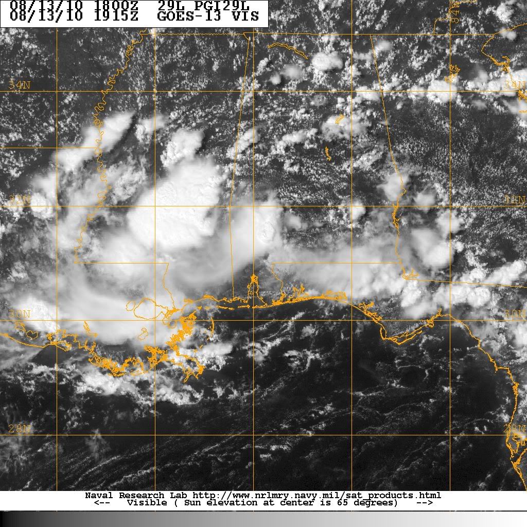
If anything x-TD5 will make for an interesting weekend and start to the next week especially since things are pretty quiet elsewhere for the moment.
0 likes   

User avatar
KWT
Category 5
Category 5
Posts: 31415
Joined: Tue Aug 17, 2004 11:02 am
Location: UK!!!

Re: Re:

#1396 Postby KWT » Fri Aug 13, 2010 3:26 pm

Ikester wrote:
Well I said 'overly' favorable. Sure, we could see some regeneration, but proximity to land will keep it from undergoing RI.


Fair enough that does make sense then, still will be an interesting evolution, not a common set-up by any means!

Models hint at something for sure, just unsure as to how far out into the Gulf it gets, I personally think even a very small distance into the Gulf will be enough to do the trick.
0 likes   
Personal Forecast Disclaimer:
The posts in this forum are NOT official forecast and should not be used as such. They are just the opinion of the poster and may or may not be backed by sound meteorological data. They are NOT endorsed by any professional institution or storm2k.org. For official information, please refer to the NHC and NWS products

Chris_in_Tampa
Category 5
Category 5
Posts: 5075
Age: 41
Joined: Thu Jun 21, 2007 11:06 pm
Location: Tampa, Florida, USA
Contact:

Re: Models Develop Gulf System - EX-TD5 Thread

#1397 Postby Chris_in_Tampa » Fri Aug 13, 2010 3:27 pm

Despite not being on the map above, the low that was TD5 is still being actively tracked in the ATCF system, just like an invest would be. Why is this thread not in the Active Storms forum?
0 likes   

Ikester
Professional-Met
Professional-Met
Posts: 361
Age: 39
Joined: Mon Jun 21, 2010 5:00 pm
Location: Jacksonville, FL

Re: Models Develop Gulf System - EX-TD5 Thread

#1398 Postby Ikester » Fri Aug 13, 2010 3:27 pm

Cough...ALICIA...Cough :eek:
0 likes   

N2Storms
Category 1
Category 1
Posts: 324
Joined: Thu Sep 04, 2003 1:37 pm
Location: Panama City, Florida

Re:

#1399 Postby N2Storms » Fri Aug 13, 2010 3:29 pm

[quote="Stormcenter"]If anything x-TD5 will make for an interesting weekend and start to the next week especially since things are pretty quiet elsewhere for the moment.[/quote]


Our local mets don't seem to be at all concerned. Basically saying that we're going to be seeing typical summertime showers with puntuated by periods of sunshine. That doesn't mean they don't think that TD 5's remnants will re-generate. They are of the opinion that if anything does spin up, it'll be we'll to our west and we won't really be dealing w / much. After looking at the model runs, I concur with them. It's going to be off and on wet, but if there is any action, it's going to be from P'cola westward.

My personal opinion is that it will make just off shore and re-gain TD status and then minimal TS status before landfalling somewhere along the Tx / La border.
0 likes   

User avatar
KFDM Meteorologist
Professional-Met
Professional-Met
Posts: 1314
Joined: Tue May 16, 2006 9:52 pm
Location: Upper Texas Coast/Orange County

#1400 Postby KFDM Meteorologist » Fri Aug 13, 2010 3:36 pm

High RES EURO has system moving west down the LA. Coast!!
0 likes   


Return to “2010”

Who is online

Users browsing this forum: No registered users and 8 guests