ATL : INVEST 92L - MODELS

Moderator: S2k Moderators

Message
Author
User avatar
cycloneye
Admin
Admin
Posts: 139601
Age: 67
Joined: Thu Oct 10, 2002 10:54 am
Location: San Juan, Puerto Rico

Re: ATL : INVEST 92L - Models

#141 Postby cycloneye » Wed Jun 16, 2010 7:38 am

The 12 UTC SHIP forecast of shear is not pleasant for 92L.

Code: Select all

SHIPS INTENSITY FORECAST       *
                    *      GOES DATA AVAILABLE                  *
                    *      OHC  DATA AVAILABLE                  *
                    *      INVEST  AL922010  06/16/10  12 UTC   *

TIME (HR)          0     6    12    18    24    36    48    60    72    84    96   108   120
V (KT) NO LAND    30    29    29    28    27    26    26    27    27    29    32    38    42
V (KT) LAND       30    29    29    28    27    26    26    27    27    29    32    38    42
V (KT) LGE mod    30    30    29    29    28    26    25    24    24    25    26    27    29

SHEAR (KT)        27    28    31    31    29    30    27    22    22    23    26    23    22
SHEAR ADJ (KT)     1     0     0     2     4     0    -1     0     0    -4    -2    -1     1
SHEAR DIR        274   272   267   275   277   260   281   268   283   262   289   277   291
SST (C)         28.2  28.4  28.6  28.7  28.8  29.0  29.3  29.4  29.3  29.2  29.0  29.0  29.1
POT. INT. (KT)   141   143   146   147   149   152   157   158   157   155   152   152   153
ADJ. POT. INT.   141   140   142   143   146   148   152   152   150   149   146   145   146
200 MB T (C)   -53.5 -53.3 -53.3 -53.4 -53.4 -53.1 -53.2 -53.1 -53.3 -53.1 -53.2 -52.8 -53.2
TH_E DEV (C)      10    11    11    10    10    10     9    10     9    10     9    10    10
700-500 MB RH     56    55    52    54    54    58    61    59    64    60    65    65    64
GFS VTEX (KT)      6     5     5     5     4     4     3     3     3     3     3     4     4
850 MB ENV VOR   -26   -31   -27   -18   -15    -6     3     2    31    34    45    68    63
200 MB DIV       -27    -9    -6     1   -14     8     6    14     6    18    12    24    30
LAND (KM)       1017  1019   974   883   801   675   622   435   259   122   147   105    43
LAT (DEG N)     14.3  14.7  15.0  15.2  15.4  15.9  16.3  16.8  16.8  16.9  16.9  17.3  17.8
LONG(DEG W)     50.8  52.0  53.1  54.2  55.3  57.6  59.9  61.9  63.8  65.9  68.1  70.2  72.3
STM SPEED (KT)    14    12    11    11    11    11    10    10    10    10    11    10    10
HEAT CONTENT      59    66    72    77    76    83   103    95    87    95    90    99    95

  FORECAST TRACK FROM BAMM      INITIAL HEADING/SPEED (DEG/KT):280/ 16      CX,CY: -15/  3
  T-12 MAX WIND:  30            PRESSURE OF STEERING LEVEL (MB):  741  (MEAN=624)
  GOES IR BRIGHTNESS TEMP. STD DEV.  50-200 KM RAD:  27.0 (MEAN=14.5)
  % GOES IR PIXELS WITH T < -20 C    50-200 KM RAD:  47.0 (MEAN=65.0)

                        INDIVIDUAL CONTRIBUTIONS TO INTENSITY CHANGE
                         6   12   18   24   36   48   60   72   84   96  108  120
                        ----------------------------------------------------------
  SAMPLE MEAN CHANGE     1.   2.   3.   4.   6.   8.   9.  11.  11.  12.  13.  13.
  SST POTENTIAL          1.   1.   1.   3.   7.  13.  20.  24.  29.  31.  33.  34.
  VERTICAL SHEAR MAG     0.   0.  -1.  -2.  -4.  -9. -13. -16. -19. -21. -21. -21.
  VERTICAL SHEAR ADJ     0.   0.   0.   0.   0.   0.   0.   0.   1.   1.   1.   1.
  VERTICAL SHEAR DIR     0.  -1.  -2.  -2.  -4.  -5.  -7.  -8.  -9. -10. -11. -12.
  PERSISTENCE            0.  -1.  -1.  -1.  -1.  -1.  -1.  -1.  -1.   0.   0.   0.
  200/250 MB TEMP.       0.   0.   0.   0.   0.   0.   0.   0.   0.   0.   0.   0.
  THETA_E EXCESS         0.   0.   0.   0.   0.   0.  -1.  -1.  -2.  -2.  -3.  -3.
  700-500 MB RH          0.   0.   0.   0.   0.   0.  -1.  -1.  -1.  -1.  -1.  -1.
  GFS VORTEX TENDENCY    0.   0.  -1.  -1.  -2.  -2.  -3.  -3.  -3.  -3.  -3.  -3.
  850 MB ENV VORTICITY   0.  -1.  -1.  -1.  -2.  -2.  -2.  -2.  -2.  -2.  -2.  -1.
  200 MB DIVERGENCE      0.  -1.  -1.  -1.  -2.  -2.  -3.  -3.  -3.  -2.  -2.  -2.
  ZONAL STORM MOTION     0.   0.   1.   1.   2.   2.   3.   3.   4.   5.   5.   5.
  STEERING LEVEL PRES    0.   0.   0.   0.  -1.  -1.  -1.  -2.  -2.  -2.  -2.  -1.
  DAYS FROM CLIM. PEAK   0.   0.   0.   0.   0.  -1.  -1.  -1.  -1.  -1.   0.  -1.
  GOES PREDICTORS        0.  -1.  -1.  -2.  -2.  -2.  -2.  -2.  -2.  -2.  -2.  -2.
  OCEAN HEAT CONTENT     0.   0.   0.   0.   0.   1.   0.  -1.  -1.   0.   2.   5.
                        ----------------------------------------------------------
  TOTAL CHANGE          -1.  -1.  -2.  -3.  -4.  -4.  -3.  -3.  -1.   2.   8.  12.

   ** 2010 ATLANTIC RI INDEX AL922010     INVEST 06/16/10  12 UTC **
           ( 30 KT OR MORE MAX WIND INCREASE IN NEXT 24 HR)
 
 12 HR PERSISTENCE (KT):   0.0 Range:-45.0 to  30.0 Scaled/Wgted Val:  0.6/  1.3
 850-200 MB SHEAR (KT) :  29.4 Range: 26.2 to   3.2 Scaled/Wgted Val:  0.0/  0.0
 D200 (10**7s-1)       : -11.0 Range:-21.0 to 140.0 Scaled/Wgted Val:  0.1/  0.1
 POT = MPI-VMAX (KT)   : 112.4 Range: 33.5 to 126.5 Scaled/Wgted Val:  0.8/  0.6
 850-700 MB REL HUM (%):  69.0 Range: 56.0 to  85.0 Scaled/Wgted Val:  0.4/  0.3
 % area w/pixels <-30 C:  42.0 Range: 17.0 to 100.0 Scaled/Wgted Val:  0.3/  0.0
 STD DEV OF IR BR TEMP :  27.0 Range: 30.6 to   3.2 Scaled/Wgted Val:  0.1/  0.2
 Heat content (KJ/cm2) :  70.0 Range:  0.0 to 130.0 Scaled/Wgted Val:  0.5/  0.0
 
 Prob of RI for 25 kt RI threshold=    10% is   0.8 times the sample mean(12.6%)
 Prob of RI for 30 kt RI threshold=     3% is   0.3 times the sample mean( 8.1%)
 Prob of RI for 35 kt RI threshold=     1% is   0.3 times the sample mean( 4.8%)
 Prob of RI for 40 kt RI threshold=     1% is   0.3 times the sample mean( 3.4%)

   ##         ANNULAR HURRICANE INDEX (AHI) AL922010     INVEST 06/16/10  12 UTC         ##
   ## STORM NOT ANNULAR, SCREENING STEP FAILED, NPASS=2 NFAIL=5                          ##
   ## AHI=  0   (AHI OF 100 IS BEST FIT TO ANN. STRUC., 1 IS MARGINAL, 0 IS NOT ANNULAR) ##
   ##     ANNULAR INDEX RAN NORMALLY             

** PROBABILITY OF SECONDARY EYEWALL FORMATION AL922010     INVEST 06/16/2010  00 UTC **
TIME        0-12h   0-24h   0-36h   0-48h       EXPERIMENTAL PRODUCT (PrSEFoNe-model)
CLIMO (%)     0       0       0       0    <--- PROBABILITY BASED ON INTENSITY ONLY
PROB  (%)     0       0       0       0    <--- FULL MODEL RAN NORMALLY
0 likes   
Visit the Caribbean-Central America Weather Thread where you can find at first post web cams,radars
and observations from Caribbean basin members Click Here

User avatar
ronjon
Category 5
Category 5
Posts: 4672
Joined: Fri Aug 19, 2005 5:17 pm
Location: Hernando Beach, FL

Re: ATL : INVEST 92L - Models

#142 Postby ronjon » Wed Jun 16, 2010 8:38 am

06Z GFS wants to develop 92L once it reaches the GOM.

Image
0 likes   

JPmia
S2K Supporter
S2K Supporter
Posts: 1070
Joined: Thu Jun 03, 2004 11:01 pm
Location: Fort Lauderdale, FL

#143 Postby JPmia » Wed Jun 16, 2010 8:45 am

:uarrow: Now that scenario fits climatology and shouldn't be discounted just yet. Unfortunately, a new dimension to hurricane tracking this year will be the oil spill zone. The folks along the Gulf really can't take anymore I imagine and forecasting Gulf hurricane impacts will be paramount this year.
0 likes   

User avatar
SEASON_CANCELED
Category 3
Category 3
Posts: 887
Joined: Mon Jul 06, 2009 5:17 am
Location: 8 Bit Charlie Sheen

Re: ATL : INVEST 92L - Models

#144 Postby SEASON_CANCELED » Wed Jun 16, 2010 8:48 am

what effect I wonder will oil have on the intesity? If any? Or will it just toss it all ashore in the storm surge? Oh god the thought of that makes me sick
0 likes   
i am a big stupid ugly moron with an ugly face and a big butt and my butt stinks and i like to kiss my own butt

User avatar
AdamFirst
S2K Supporter
S2K Supporter
Posts: 2488
Age: 35
Joined: Thu Aug 14, 2008 10:54 am
Location: Port Saint Lucie, FL

#145 Postby AdamFirst » Wed Jun 16, 2010 9:03 am

The oily water most likely won't help or hurt any tropical system. The concern is exactly what you said, a storm tide bringing in oil-soaked water onto the mainland. Imagine a massive oil storm surge riding up mobile bay...just one nightmare scenario.
0 likes   
Dolphins Marlins Canes Golden Panthers HEAT
Andrew 1992 - Irene 1999 - Frances 2004 - Jeanne 2004 - Wilma 2005 - Fay 2008 - Isaac 2012 - Matthew 2016 - Irma 2017 - Dorian 2019 - Ian 2022 - Nicole 2022

duris
Tropical Storm
Tropical Storm
Posts: 249
Joined: Wed Sep 08, 2004 9:21 am
Location: New Orleans

Re:

#146 Postby duris » Wed Jun 16, 2010 9:37 am

AdamFirst wrote:The oily water most likely won't help or hurt any tropical system. The concern is exactly what you said, a storm tide bringing in oil-soaked water onto the mainland. Imagine a massive oil storm surge riding up mobile bay...just one nightmare scenario.


Jeff Masters had good write up on what a hurricane could do to spill. There are potential impacts of oil on tropical system. http://www.wunderground.com/blog/JeffMa ... rynum=1492
0 likes   

User avatar
cycloneye
Admin
Admin
Posts: 139601
Age: 67
Joined: Thu Oct 10, 2002 10:54 am
Location: San Juan, Puerto Rico

Re: ATL : INVEST 92L - Models

#147 Postby cycloneye » Wed Jun 16, 2010 10:14 am

Well,the NAM has a pretty interesting low pressure (92L) just north of Puerto Rico by next sunday,but is the NAM. :)

Image
0 likes   
Visit the Caribbean-Central America Weather Thread where you can find at first post web cams,radars
and observations from Caribbean basin members Click Here

User avatar
Ivanhater
Storm2k Moderator
Storm2k Moderator
Posts: 10859
Age: 37
Joined: Fri Jul 01, 2005 8:25 am
Location: Pensacola

Re: ATL : INVEST 92L - Models

#148 Postby Ivanhater » Wed Jun 16, 2010 10:39 am

It is the NAM Luis, but look for trends..it has been getting stronger with each run, along with other models. GFS has been showing 92l stronger once in the gulf. The latest convective burst helps this scenario
0 likes   
Michael

User avatar
barometerJane61
Tropical Depression
Tropical Depression
Posts: 51
Joined: Sun May 30, 2010 8:27 am
Location: Texas

Re:

#149 Postby barometerJane61 » Thu Jun 17, 2010 11:09 am

AdamFirst wrote:The oily water most likely won't help or hurt any tropical system. The concern is exactly what you said, a storm tide bringing in oil-soaked water onto the mainland. Imagine a massive oil storm surge riding up mobile bay...just one nightmare scenario.


Just the thought of more oil being thrown further inland from a hurricane makes me ill to my stomache.This is one season where i especially do not want to see a landfall anywhere along the gulf coast :(
0 likes   

User avatar
cycloneye
Admin
Admin
Posts: 139601
Age: 67
Joined: Thu Oct 10, 2002 10:54 am
Location: San Juan, Puerto Rico

Re: ATL : INVEST 92L - Models

#150 Postby cycloneye » Thu Jun 17, 2010 1:34 pm

And the BAMS are also back!!

18 UTC BAMS

WHXX01 KWBC 171831
CHGHUR
TROPICAL CYCLONE GUIDANCE MESSAGE
NWS TPC/NATIONAL HURRICANE CENTER MIAMI FL
1831 UTC THU JUN 17 2010

DISCLAIMER...NUMERICAL MODELS ARE SUBJECT TO LARGE ERRORS.
PLEASE REFER TO NHC OFFICIAL FORECASTS FOR TROPICAL CYCLONE
AND SUBTROPICAL CYCLONE INFORMATION.

ATLANTIC OBJECTIVE AIDS FOR

DISTURBANCE INVEST (AL922010) 20100617 1800 UTC

...00 HRS... ...12 HRS... ...24 HRS. .. ...36 HRS...
100617 1800 100618 0600 100618 1800 100619 0600

LAT LON LAT LON LAT LON LAT LON
BAMS 16.0N 58.5W 16.5N 61.5W 17.1N 64.4W 17.3N 67.2W
BAMD 16.0N 58.5W 16.5N 59.7W 16.9N 61.0W 17.1N 62.4W
BAMM 16.0N 58.5W 16.4N 60.7W 17.0N 62.8W 17.2N 64.8W
LBAR 16.0N 58.5W 16.4N 60.8W 17.1N 63.5W 17.7N 66.2W
SHIP 25KTS 23KTS 22KTS 22KTS
DSHP 25KTS 23KTS 22KTS 22KTS

...48 HRS... ...72 HRS... ...96 HRS. .. ..120 HRS...
100619 1800 100620 1800 100621 1800 100622 1800

LAT LON LAT LON LAT LON LAT LON
BAMS 17.8N 70.1W 18.2N 75.5W 18.5N 80.1W 18.5N 84.4W
BAMD 17.3N 63.8W 17.8N 67.1W 19.2N 69.9W 20.7N 72.5W
BAMM 17.4N 66.9W 17.9N 71.0W 18.6N 74.3W 19.5N 77.2W
LBAR 18.3N 69.1W 19.9N 74.1W 22.1N 77.3W 23.1N 78.9W
SHIP 24KTS 26KTS 35KTS 49KTS
DSHP 24KTS 26KTS 30KTS 44KTS

...INITIAL CONDITIONS...
LATCUR = 16.0N LONCUR = 58.5W DIRCUR = 280DEG SPDCUR = 15KT
LATM12 = 15.5N LONM12 = 55.4W DIRM12 = 282DEG SPDM12 = 17KT
LATM24 = 14.8N LONM24 = 52.1W
WNDCUR = 25KT RMAXWD = 60NM WNDM12 = 25KT
CENPRS = 1012MB OUTPRS = 1013MB OUTRAD = 125NM SDEPTH = M
RD34NE = 0NM RD34SE = 0NM RD34SW = 0NM RD34NW = 0NM

$$
0 likes   
Visit the Caribbean-Central America Weather Thread where you can find at first post web cams,radars
and observations from Caribbean basin members Click Here

User avatar
Ivanhater
Storm2k Moderator
Storm2k Moderator
Posts: 10859
Age: 37
Joined: Fri Jul 01, 2005 8:25 am
Location: Pensacola

Re: ATL : INVEST 92L - Models

#151 Postby Ivanhater » Thu Jun 17, 2010 1:36 pm

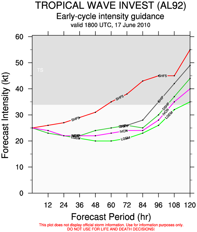
Interesting trend we are seeing today...SHIPS bring it to tropical storm status and GFS also develops down the line.
0 likes   
Michael

User avatar
cycloneye
Admin
Admin
Posts: 139601
Age: 67
Joined: Thu Oct 10, 2002 10:54 am
Location: San Juan, Puerto Rico

Re: ATL : INVEST 92L - Models

#152 Postby cycloneye » Thu Jun 17, 2010 1:42 pm

Here is the graphic.

Image
0 likes   
Visit the Caribbean-Central America Weather Thread where you can find at first post web cams,radars
and observations from Caribbean basin members Click Here

User avatar
Blown Away
S2K Supporter
S2K Supporter
Posts: 9874
Joined: Wed May 26, 2004 6:17 am

Re: ATL : INVEST 92L - Models

#153 Postby Blown Away » Thu Jun 17, 2010 3:22 pm

I don't know how much we can read into the 18z Bam's, but it seems a deeper 92L takes a little more northerly track.
0 likes   
Hurricane Eye Experience: David 79, Irene 99, Frances 04, Jeanne 04, Wilma 05... EYE COMING MY WAY IN 2024…
Hurricane Brush Experience: Andrew 92, Erin 95, Floyd 99, Matthew 16, Irma 17, Ian 22, Nicole 22…

User avatar
gatorcane
S2K Supporter
S2K Supporter
Posts: 23499
Age: 46
Joined: Sun Mar 13, 2005 3:54 pm
Location: Boca Raton, FL

#154 Postby gatorcane » Thu Jun 17, 2010 3:55 pm

All of the models I looked at (12Z) runs keep a vigorous tropical wave heading W to WNW. Seems reasonable to me. Some show some possibile consolidation of a low down the road but not buying that as it is so far out at this point and only a couple of models show this solution. Consensus is quite good from the models on no development at least for the next 4-5 days so seems that the forecast is pretty clear-cut at this point.
0 likes   

User avatar
Blown Away
S2K Supporter
S2K Supporter
Posts: 9874
Joined: Wed May 26, 2004 6:17 am

Re:

#155 Postby Blown Away » Thu Jun 17, 2010 4:00 pm

gatorcane wrote:All of the models I looked at (12Z) runs keep a vigorous tropical wave heading W to WNW. Seems reasonable to me. Some show some possibile consolidation of a low in the GOM but not buying that as it is so far out at this point and only a couple of models show this solution. Consensus is quite good from the models on no development at least for the next 4-5 days so seems that the forecast is pretty clear-cut at this point.


BAMD slows and takes 92L more northely if there is development whereas the BAMS races a shallow 92L west.
0 likes   
Hurricane Eye Experience: David 79, Irene 99, Frances 04, Jeanne 04, Wilma 05... EYE COMING MY WAY IN 2024…
Hurricane Brush Experience: Andrew 92, Erin 95, Floyd 99, Matthew 16, Irma 17, Ian 22, Nicole 22…

User avatar
Ivanhater
Storm2k Moderator
Storm2k Moderator
Posts: 10859
Age: 37
Joined: Fri Jul 01, 2005 8:25 am
Location: Pensacola

Re: ATL : INVEST 92L - Models

#156 Postby Ivanhater » Thu Jun 17, 2010 4:00 pm

Image
0 likes   
Michael

User avatar
SEASON_CANCELED
Category 3
Category 3
Posts: 887
Joined: Mon Jul 06, 2009 5:17 am
Location: 8 Bit Charlie Sheen

#157 Postby SEASON_CANCELED » Thu Jun 17, 2010 5:33 pm

I would imagine a fierce Category 2 or 3 storm would disrupt or undo any efforts to stop the oil spill. So like this really sucks. And we are talking about this in early June, which is unfortunate.
0 likes   
i am a big stupid ugly moron with an ugly face and a big butt and my butt stinks and i like to kiss my own butt

User avatar
Duddy
Category 1
Category 1
Posts: 363
Joined: Sat Jun 10, 2006 9:07 pm
Location: Wilmington, NC

Re: ATL : INVEST 92L - Models

#158 Postby Duddy » Thu Jun 17, 2010 5:40 pm

Ivan where can I find that graphic? Thanks!

Also, not good. Seems the trend is for 92L to develop down the road. Can you IMAGINE the news when a hurricane starts heading towards the oil spill?

It would be like a scifi movie.
0 likes   

User avatar
cycloneye
Admin
Admin
Posts: 139601
Age: 67
Joined: Thu Oct 10, 2002 10:54 am
Location: San Juan, Puerto Rico

Re: ATL : INVEST 92L - MODELS

#159 Postby cycloneye » Thu Jun 17, 2010 7:47 pm

00 UTC BAMS

Yes,a tad slower from 15kts to 12kts.

549
WHXX01 KWBC 180034
CHGHUR
TROPICAL CYCLONE GUIDANCE MESSAGE
NWS TPC/NATIONAL HURRICANE CENTER MIAMI FL
0034 UTC FRI JUN 18 2010

DISCLAIMER...NUMERICAL MODELS ARE SUBJECT TO LARGE ERRORS.
PLEASE REFER TO NHC OFFICIAL FORECASTS FOR TROPICAL CYCLONE
AND SUBTROPICAL CYCLONE INFORMATION.

ATLANTIC OBJECTIVE AIDS FOR

DISTURBANCE INVEST (AL922010) 20100618 0000 UTC

...00 HRS... ...12 HRS... ...24 HRS. .. ...36 HRS...
100618 0000 100618 1200 100619 0000 100619 1200

LAT LON LAT LON LAT LON LAT LON
BAMS 16.1N 59.3W 16.8N 62.1W 17.4N 64.8W 18.0N 67.6W
BAMD 16.1N 59.3W 16.6N 60.5W 17.2N 61.7W 17.6N 62.8W
BAMM 16.1N 59.3W 16.6N 61.5W 17.2N 63.6W 17.6N 65.7W
LBAR 16.1N 59.3W 16.8N 61.5W 17.5N 63.9W 18.2N 66.6W
SHIP 25KTS 24KTS 23KTS 24KTS
DSHP 25KTS 24KTS 23KTS 24KTS

...48 HRS... ...72 HRS... ...96 HRS. .. ..120 HRS...
100620 0000 100621 0000 100622 0000 100623 0000

LAT LON LAT LON LAT LON LAT LON
BAMS 18.5N 70.1W 19.4N 75.0W 20.1N 79.2W 20.6N 83.0W
BAMD 17.9N 64.1W 18.9N 66.8W 20.7N 69.3W 22.7N 71.9W
BAMM 17.9N 67.7W 18.6N 71.4W 19.6N 74.5W 20.9N 77.5W
LBAR 18.9N 69.2W 20.9N 73.8W 23.4N 77.0W 25.6N 80.0W
SHIP 26KTS 28KTS 36KTS 48KTS
DSHP 26KTS 25KTS 35KTS 29KTS

...INITIAL CONDITIONS...
LATCUR = 16.1N LONCUR = 59.3W DIRCUR = 285DEG SPDCUR = 12KT
LATM12 = 15.8N LONM12 = 57.2W DIRM12 = 281DEG SPDM12 = 14KT
LATM24 = 15.1N LONM24 = 53.7W
WNDCUR = 25KT RMAXWD = 60NM WNDM12 = 25KT
CENPRS = 1011MB OUTPRS = 1013MB OUTRAD = 125NM SDEPTH = M
RD34NE = 0NM RD34SE = 0NM RD34SW = 0NM RD34NW = 0NM

Image
0 likes   
Visit the Caribbean-Central America Weather Thread where you can find at first post web cams,radars
and observations from Caribbean basin members Click Here

User avatar
cycloneye
Admin
Admin
Posts: 139601
Age: 67
Joined: Thu Oct 10, 2002 10:54 am
Location: San Juan, Puerto Rico

Re: ATL : INVEST 92L - MODELS

#160 Postby cycloneye » Thu Jun 17, 2010 8:09 pm

00 UTC SHIP Run

Shear drops at the end of run to 13kts.

Code: Select all

                    *   ATLANTIC SHIPS INTENSITY FORECAST       *
                    *      GOES DATA AVAILABLE                  *
                    *      OHC  DATA AVAILABLE                  *
                    *  INVEST      AL922010  06/18/10  00 UTC   *

TIME (HR)          0     6    12    18    24    36    48    60    72    84    96   108   120
V (KT) NO LAND    25    25    24    23    23    24    26    26    28    31    36    43    48
V (KT) LAND       25    25    24    23    23    24    26    26    25    30    35    31    29
V (KT) LGE mod    25    25    24    23    23    21    21    23    23    28    30    30    28

SHEAR (KT)        36    32    30    29    30    27    27    22    20    22    20    22    13
SHEAR ADJ (KT)     3     4     3     2     1     1    -1     3     2    -2     0    -1     0
SHEAR DIR        268   274   270   272   268   282   270   289   279   292   269   274   267
SST (C)         29.2  29.3  29.4  29.3  29.2  29.0  28.8  28.9  29.1  29.3  29.5  29.6  29.7
POT. INT. (KT)   155   157   159   157   155   152   148   150   152   156   159   161   163
ADJ. POT. INT.   150   153   154   151   149   144   140   141   142   145   147   148   149
200 MB T (C)   -52.9 -52.8 -52.9 -52.9 -52.9 -53.1 -53.0 -53.5 -53.1 -53.6 -53.3 -53.6 -53.0
TH_E DEV (C)      12    11    11    11    11     9    10    10    11    10    11    10    11
700-500 MB RH     53    54    53    55    50    57    56    60    60    60    60    63    62
GFS VTEX (KT)      5     5     5     5     4     4     4     3     4     4     4     5     5
850 MB ENV VOR   -16   -17   -14    -7   -10    12    23    39    57    59    43    57    47
200 MB DIV         4     8     9    17     0     9    22     2    18    29    29    32    15
LAND (KM)        616   602   483   368   253    49    54    17   -45    20    47   -22   -22
LAT (DEG N)     16.1  16.4  16.6  16.9  17.2  17.6  17.9  18.2  18.6  19.0  19.6  20.1  20.9
LONG(DEG W)     59.3  60.4  61.5  62.6  63.6  65.7  67.7  69.7  71.4  73.0  74.5  76.0  77.5
STM SPEED (KT)    10    11    11    10    10    10    10     9     8     8     8     8     8
HEAT CONTENT     108   107    19   102    86    74    74    77    75    98    93    81    66

  FORECAST TRACK FROM BAMM      INITIAL HEADING/SPEED (DEG/KT):285/ 12      CX,CY: -11/  3
  T-12 MAX WIND:  25            PRESSURE OF STEERING LEVEL (MB):  617  (MEAN=624)
  GOES IR BRIGHTNESS TEMP. STD DEV.  50-200 KM RAD:  32.5 (MEAN=14.5)
  % GOES IR PIXELS WITH T < -20 C    50-200 KM RAD:  34.0 (MEAN=65.0)

                        INDIVIDUAL CONTRIBUTIONS TO INTENSITY CHANGE
                         6   12   18   24   36   48   60   72   84   96  108  120
                        ----------------------------------------------------------
  SAMPLE MEAN CHANGE     1.   2.   3.   4.   6.   8.   9.  11.  11.  12.  13.  13.
  SST POTENTIAL          0.   0.   0.   1.   6.  13.  21.  26.  30.  34.  36.  38.
  VERTICAL SHEAR MAG     1.   1.   1.   1.  -2.  -6. -12. -14. -18. -19. -18. -18.
  VERTICAL SHEAR ADJ     0.   0.  -1.  -1.  -1.  -1.  -1.  -1.  -1.  -1.  -1.   0.
  VERTICAL SHEAR DIR     0.  -1.  -1.  -2.  -3.  -4.  -6.  -7.  -7.  -8.  -9. -10.
  PERSISTENCE            0.  -1.  -1.  -1.  -1.  -1.  -1.  -1.  -1.   0.   0.   0.
  200/250 MB TEMP.       0.   0.   0.  -1.  -1.  -1.  -1.  -1.  -1.  -1.   0.   0.
  THETA_E EXCESS         0.   0.   0.   0.   0.   0.   0.   0.  -1.  -1.  -1.  -1.
  700-500 MB RH          0.   0.   0.   0.   0.   0.   0.   0.  -1.  -1.  -1.  -1.
  GFS VORTEX TENDENCY    0.   0.   0.  -1.  -1.  -2.  -2.  -2.  -2.  -3.  -2.  -2.
  850 MB ENV VORTICITY   0.  -1.  -1.  -1.  -1.  -1.  -1.  -1.  -1.   0.   0.   0.
  200 MB DIVERGENCE      0.   0.   0.  -1.  -1.  -1.  -1.  -2.  -1.  -1.  -1.   0.
  ZONAL STORM MOTION     0.   0.   0.   1.   1.   1.   2.   2.   2.   3.   3.   3.
  STEERING LEVEL PRES    0.   0.   0.   0.   0.   0.   0.   0.   0.   0.   0.   0.
  DAYS FROM CLIM. PEAK   0.   0.   0.   0.   0.  -1.  -1.  -1.  -1.  -1.   0.  -1.
  GOES PREDICTORS       -1.  -2.  -2.  -3.  -4.  -4.  -4.  -4.  -3.  -3.  -3.  -3.
  OCEAN HEAT CONTENT     0.   0.   1.   1.   1.   1.   0.  -1.  -1.   0.   2.   4.
                        ----------------------------------------------------------
  TOTAL CHANGE           0.  -1.  -1.  -2.  -1.   1.   1.   3.   6.  11.  18.  23.

   ** 2010 ATLANTIC RI INDEX AL922010 INVEST     06/18/10  00 UTC **
           ( 30 KT OR MORE MAX WIND INCREASE IN NEXT 24 HR)
 
 12 HR PERSISTENCE (KT):   0.0 Range:-45.0 to  30.0 Scaled/Wgted Val:  0.6/  1.3
 850-200 MB SHEAR (KT) :  31.5 Range: 26.2 to   3.2 Scaled/Wgted Val:  0.0/  0.0
 D200 (10**7s-1)       :   7.6 Range:-21.0 to 140.0 Scaled/Wgted Val:  0.2/  0.3
 POT = MPI-VMAX (KT)   : 126.4 Range: 33.5 to 126.5 Scaled/Wgted Val:  1.0/  0.7
 850-700 MB REL HUM (%):  69.2 Range: 56.0 to  85.0 Scaled/Wgted Val:  0.5/  0.3
 % area w/pixels <-30 C:  31.0 Range: 17.0 to 100.0 Scaled/Wgted Val:  0.2/  0.0
 STD DEV OF IR BR TEMP :  32.5 Range: 30.6 to   3.2 Scaled/Wgted Val:  0.0/  0.0
 Heat content (KJ/cm2) :  84.4 Range:  0.0 to 130.0 Scaled/Wgted Val:  0.6/  0.1
 
 Prob of RI for 25 kt RI threshold=    10% is   0.8 times the sample mean(12.6%)
 Prob of RI for 30 kt RI threshold=     3% is   0.3 times the sample mean( 8.1%)
 Prob of RI for 35 kt RI threshold=     1% is   0.3 times the sample mean( 4.8%)
 Prob of RI for 40 kt RI threshold=     1% is   0.3 times the sample mean( 3.4%)

   ##         ANNULAR HURRICANE INDEX (AHI) AL922010 INVEST     06/18/10  00 UTC         ##
   ## STORM NOT ANNULAR, SCREENING STEP FAILED, NPASS=2 NFAIL=5                          ##
   ## AHI=  0   (AHI OF 100 IS BEST FIT TO ANN. STRUC., 1 IS MARGINAL, 0 IS NOT ANNULAR) ##
   ##     ANNULAR INDEX RAN NORMALLY             

** PROBABILITY OF SECONDARY EYEWALL FORMATION AL922010 INVEST     06/18/2010  00 UTC **
TIME        0-12h   0-24h   0-36h   0-48h       EXPERIMENTAL PRODUCT (PrSEFoNe-model)
CLIMO (%)     0       0       0       0    <--- PROBABILITY BASED ON INTENSITY ONLY
PROB  (%)     0       0       0       0    <--- FULL MODEL RAN NORMALLY

0 likes   
Visit the Caribbean-Central America Weather Thread where you can find at first post web cams,radars
and observations from Caribbean basin members Click Here


Return to “2010”

Who is online

Users browsing this forum: No registered users and 29 guests