UW - CIMSS
ADVANCED DVORAK TECHNIQUE
ADT-Version 8.1.1
Tropical Cyclone Intensity Algorithm
----- Current Analysis -----
Date : 26 AUG 2010 Time : 211500 UTC
Lat : 25:10:40 N Lon : 56:52:41 W
CI# /Pressure/ Vmax
5.5 / 959.7mb/102.0kt
Final T# Adj T# Raw T#
5.5 5.7 5.7
Latitude bias adjustment to MSLP : -0.3mb
Estimated radius of max. wind based on IR : 24 km
Center Temp : +10.4C Cloud Region Temp : -61.4C
Scene Type : EYE
Positioning Method : RING/SPIRAL COMBINATION
Ocean Basin : ATLANTIC
Dvorak CI > MSLP Conversion Used : ATLANTIC
Tno/CI Rules : Constraint Limits : NO LIMIT
Weakening Flag : OFF
Rapid Dissipation Flag : OFF
ATL: Ex-Hurricane DANIELLE - Discussion
Moderator: S2k Moderators
-
neospaceblue

- Tropical Storm

- Posts: 112
- Age: 32
- Joined: Fri Aug 10, 2007 3:17 pm
- Location: Newport News, VA
-
cycloneye

- Admin

- Posts: 149585
- Age: 69
- Joined: Thu Oct 10, 2002 10:54 am
- Location: San Juan, Puerto Rico
Re: ATL: Hurricane DANIELLE - Discussion
Beautiful sunset.

0 likes
Visit the Caribbean-Central America Weather Thread where you can find at first post web cams,radars
and observations from Caribbean basin members Click Here
and observations from Caribbean basin members Click Here

Re: ATL: Hurricane DANIELLE - Discussion
0 likes
-
leanne_uk
- Tropical Storm
- Posts: 214
- Age: 43
- Joined: Fri Sep 04, 2009 4:38 pm
- Location: Loughborough countryside, Leicestershire, UK
Re: ATL: Hurricane DANIELLE - Discussion
I've just saved this image as my screen saver  totally beautiful.
cycloneye wrote:Beautiful sunset.
http://www.ssd.noaa.gov/goes/flt/t1/rgb-l.jpg
0 likes

Looking mighty impressive, I suspect we see an upgrade to major status next advisory unless it weakens again in the next few hours.
0 likes
Personal Forecast Disclaimer:
The posts in this forum are NOT official forecast and should not be used as such. They are just the opinion of the poster and may or may not be backed by sound meteorological data. They are NOT endorsed by any professional institution or storm2k.org. For official information, please refer to the NHC and NWS products
The posts in this forum are NOT official forecast and should not be used as such. They are just the opinion of the poster and may or may not be backed by sound meteorological data. They are NOT endorsed by any professional institution or storm2k.org. For official information, please refer to the NHC and NWS products
-
dixiebreeze
- S2K Supporter

- Posts: 5140
- Joined: Wed Sep 03, 2003 5:07 pm
- Location: crystal river, fla.
Re:
KWT wrote:Looking mighty impressive, I suspect we see an upgrade to major status next advisory unless it weakens again in the next few hours.
26/1745 UTC 24.8N 56.4W T5.0/5.0 DANIELLE -- Atlantic
0 likes
Re: ATL: Hurricane DANIELLE - Discussion
tolakram wrote:cpdaman wrote:could someone tell me why
with the current steering flow and now that the upper trough is getting out of the way further SW and pushing from a earlier position just WNW of her (which i believe forced her more NW'erly) .....why she wouldn't turn Almost due westerly tonite?
i think right now she could be (in the process) of turning WNW
There is, or will be, strong high pressure over the US east coast right now. What steering flow are you looking at?
This is the steering flow i'm looking at
Will still move NW for another day, then turn.

http://cimss.ssec.wisc.edu/tropic/real- ... 8dlm4.html
or this
http://cimss.ssec.wisc.edu/tropic/real- ... 8dlm3.html
seems like she should slow and move slowly westward based on that for the next 36-48 hours....
Last edited by cpdaman on Thu Aug 26, 2010 6:33 pm, edited 1 time in total.
0 likes

Re: ATL: Hurricane DANIELLE - Discussion
she looks beautiful......
in bermuda don't let your guard down yet.
tolakram doesn't she looks like she want to make a left hand turn on the next frame or two....lol.....but really looking at the steering flow i posted (i'm trying to learn) why would she not go westward later tonite thru tommorrow (next 24 at least)?
in bermuda don't let your guard down yet.
tolakram doesn't she looks like she want to make a left hand turn on the next frame or two....lol.....but really looking at the steering flow i posted (i'm trying to learn) why would she not go westward later tonite thru tommorrow (next 24 at least)?
0 likes
-
cycloneye
- Admin
- Posts: 149585
- Age: 69
- Joined: Thu Oct 10, 2002 10:54 am
- Location: San Juan, Puerto Rico
Re: ATL: Hurricane DANIELLE - Discussion
00z Best Track
AL, 06, 2010082700, , BEST, 0, 255N, 572W, 95, 968, HU
ftp://ftp.tpc.ncep.noaa.gov/atcf/tcweb/ ... 010.invest
Shy from major, but NHC can decide to bump it just before advisory is out depending on how it looks.
AL, 06, 2010082700, , BEST, 0, 255N, 572W, 95, 968, HU
ftp://ftp.tpc.ncep.noaa.gov/atcf/tcweb/ ... 010.invest
Shy from major, but NHC can decide to bump it just before advisory is out depending on how it looks.
0 likes
Visit the Caribbean-Central America Weather Thread where you can find at first post web cams,radars
and observations from Caribbean basin members Click Here
and observations from Caribbean basin members Click Here

-
plasticup

Re: ATL: Hurricane DANIELLE - Discussion
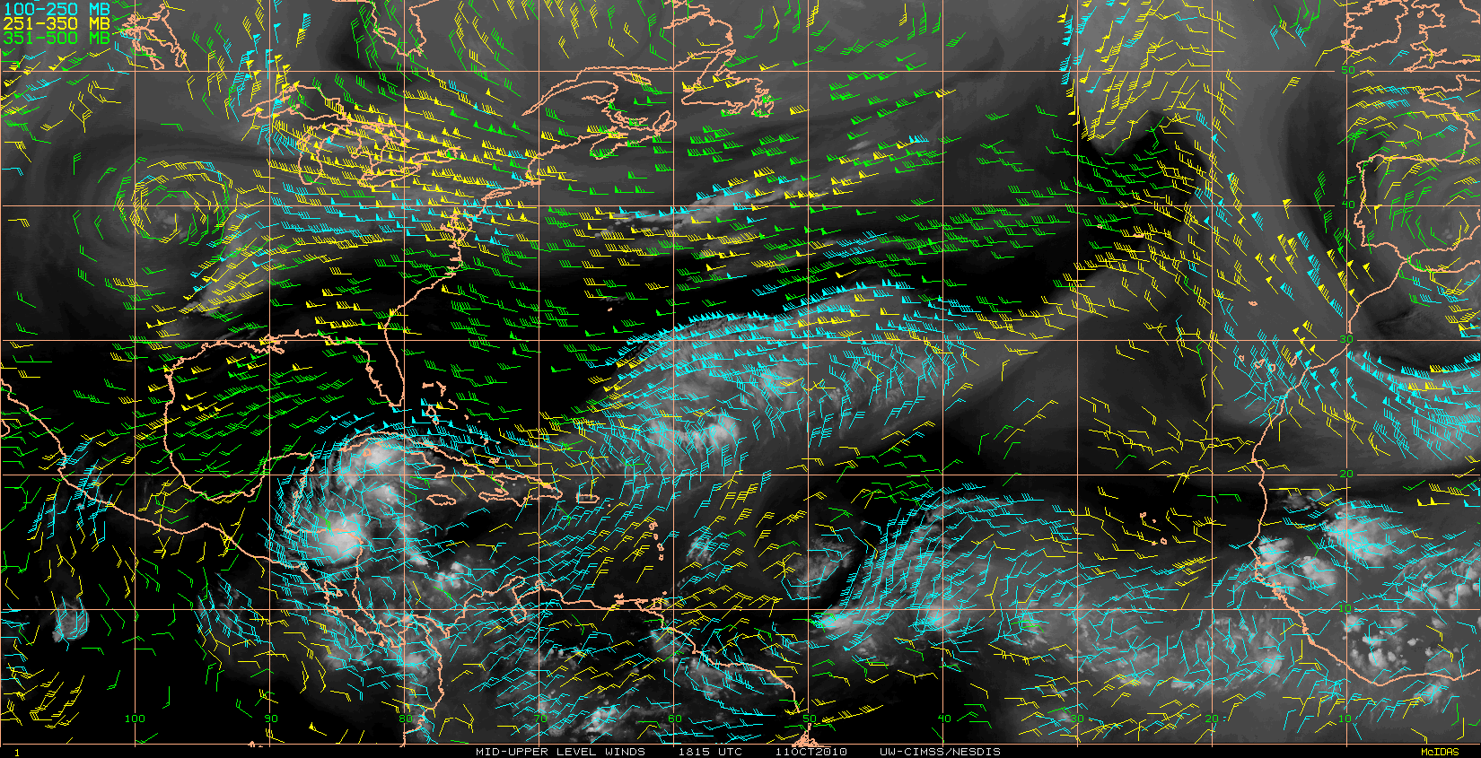
It looks like there is an UL Jet flowing SW to NE across the SE Quad.
That is inhibiting outflow there.
Rest of the UL outflow looks great - a well established poleward outflow channel.
Also looks like dry air has finally shaken out.
One established infeed directly from the ITCZ, another being established into the east Carib, and a third that looks like it could form into the Bahamas.
http://cimss.ssec.wisc.edu/tropic/real- ... t72hrs.gif
0 likes


-
Sean in New Orleans

- Category 5

- Posts: 1794
- Joined: Thu Aug 28, 2003 7:26 pm
- Location: New Orleans, LA 30.0N 90.0W
- Contact:

Who is online
Users browsing this forum: No registered users and 50 guests