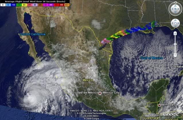
EPAC : EX TROPICAL DEPRESSION AGATHA

Moderator: S2k Moderators

Message
Author
User avatar
srainhoutx
S2K Supporter
S2K Supporter
Posts: 6919
Age: 67
Joined: Sun Jan 14, 2007 11:34 am
Location: Haywood County, NC
Contact:

Re: EPAC : TROPICAL STORM AGATHA

#261 Postby srainhoutx » Sat May 29, 2010 10:16 am

cycloneye wrote:
gatorcane wrote:Well it would appear it had enough time over water to get named. Earlier this week, was thinking it would not have enough time giving it a 50% shot of getting named. Nice outflow over the system, the only thing really keeping it from going to hurricane status is the fact it won't be over water long enough it looks like.


Agreed. If this would be more away from land with those bombing sst's there,it would go thru rapid intensification to hurricane status.


It's moving slowly if at all. If the low level vortex can sustain convection throughout the day, we may very well see Agatha approach Hurricane Status IMHO. We shall see.
0 likes   
Carla/Alicia/Jerry(In The Eye)/Michelle/Charley/Ivan/Dennis/Katrina/Rita/Wilma/Ike/Harvey

Member: National Weather Association
Wx Infinity Forums
http://wxinfinity.com/index.php

Facebook.com/WeatherInfinity
Twitter @WeatherInfinity

User avatar
Trader Ron
S2K Supporter
S2K Supporter
Posts: 927
Joined: Tue Jul 22, 2003 7:25 pm
Location: Naples,Fl
Contact:

#262 Postby Trader Ron » Sat May 29, 2010 10:18 am

Isolated amounts of 30 inches of rain. :cry: :(
0 likes   

User avatar
KWT
Category 5
Category 5
Posts: 31415
Joined: Tue Aug 17, 2004 11:02 am
Location: UK!!!

Re: EPAC : TROPICAL STORM AGATHA

#263 Postby KWT » Sat May 29, 2010 10:27 am

srainhoutx wrote:
It's moving slowly if at all. If the low level vortex can sustain convection throughout the day, we may very well see Agatha approach Hurricane Status IMHO. We shall see.


I do think it is moving but its slow, if it does stay over water for the next 24hrs or so then I think you'd probasbly be right, I wouldn't rule out hurricane status just yet either, though as it gets closer to land those mountions could start to play a role...though its not being an issue for the inflow so any moderation it'll have will probably be slight.

I'd say 65-70mph probably the call I'd make right now given the current structure and apperence...
0 likes   
Personal Forecast Disclaimer:
The posts in this forum are NOT official forecast and should not be used as such. They are just the opinion of the poster and may or may not be backed by sound meteorological data. They are NOT endorsed by any professional institution or storm2k.org. For official information, please refer to the NHC and NWS products

Frank2
Category 5
Category 5
Posts: 4061
Joined: Mon Jul 25, 2005 12:47 pm

Re: EPAC : TROPICAL STORM AGATHA

#264 Postby Frank2 » Sat May 29, 2010 10:42 am

I am actually surprised there is no recon scheduled for this storm that I can tell? Seems there has been ample time for the 24 hour window, and it is a threat to land (with a chance it could rapidly strengthen)


Not enough time before it reaches land and besides the AF usually doesn't fly systems in the EPAC, though I'm sure they'll keep an eye on it in case it regenerates once the remnants move into the Caribbean Sea - not to mention that the AF Reserve aircraft (located on the Gulf coast) might have already been tasked for oil spill-related flights...

Frank
0 likes   

User avatar
srainhoutx
S2K Supporter
S2K Supporter
Posts: 6919
Age: 67
Joined: Sun Jan 14, 2007 11:34 am
Location: Haywood County, NC
Contact:

Re: EPAC : TROPICAL STORM AGATHA

#265 Postby srainhoutx » Sat May 29, 2010 10:43 am

Code: Select all

 UW - CIMSS                     
              ADVANCED DVORAK TECHNIQUE       
                  ADT-Version 8.1.1               
         Tropical Cyclone Intensity Algorithm       

             ----- Current Analysis -----
     Date :  29 MAY 2010    Time :   144500 UTC
      Lat :   13:05:29 N     Lon :   93:13:00 W

     
                CI# /Pressure/ Vmax
                2.6 / 995.8mb/ 37.0kt

     
             Final T#  Adj T#  Raw T#
                2.6     2.7     2.9

     Latitude bias adjustment to MSLP :  +0.0mb

 Center Temp : -67.9C    Cloud Region Temp : -68.2C

 Scene Type : UNIFORM CDO CLOUD REGION

 Positioning Method : FORECAST INTERPOLATION

 Ocean Basin : EAST PACIFIC 
 Dvorak CI > MSLP Conversion Used : PACIFIC   

 Tno/CI Rules : Constraint Limits : 0.2T/hour
                   Weakening Flag : OFF   
           Rapid Dissipation Flag : OFF   
0 likes   
Carla/Alicia/Jerry(In The Eye)/Michelle/Charley/Ivan/Dennis/Katrina/Rita/Wilma/Ike/Harvey

Member: National Weather Association
Wx Infinity Forums
http://wxinfinity.com/index.php

Facebook.com/WeatherInfinity
Twitter @WeatherInfinity

User avatar
brunota2003
S2K Supporter
S2K Supporter
Posts: 9476
Age: 34
Joined: Sat Jul 30, 2005 9:56 pm
Location: Stanton, KY...formerly Havelock, NC
Contact:

Re: EPAC : TROPICAL STORM AGATHA

#266 Postby brunota2003 » Sat May 29, 2010 10:51 am

Frank2 wrote:
I am actually surprised there is no recon scheduled for this storm that I can tell? Seems there has been ample time for the 24 hour window, and it is a threat to land (with a chance it could rapidly strengthen)


Not enough time before it reaches land and besides the AF usually doesn't fly systems in the EPAC, though I'm sure they'll keep an eye on it in case it regenerates once the remnants move into the Caribbean Sea - not to mention that the AF Reserve aircraft (located on the Gulf coast) might have already been tasked for oil spill-related flights...

Frank

I thought they did fly storms in the EPAC? Guess only the ones further up north, maybe too much going on or no clearance to fly down there (or simply too far). It'd be a long flight, that's for sure!
0 likes   

User avatar
HURAKAN
Professional-Met
Professional-Met
Posts: 46086
Age: 38
Joined: Thu May 20, 2004 4:34 pm
Location: Key West, FL
Contact:

#267 Postby HURAKAN » Sat May 29, 2010 10:55 am

There are RECON mission into the EPAC but usually for hurricanes, not storms.

Last storm was Rick:

URPN11 KNHC 201942
97779 19340 31226 07209 76100 20041 68//3 /5754
RMK AF306 0220E RICK OB 24
LAST REPORT
0 likes   

User avatar
cycloneye
Admin
Admin
Posts: 143871
Age: 68
Joined: Thu Oct 10, 2002 10:54 am
Location: San Juan, Puerto Rico

Re: EPAC : TROPICAL STORM AGATHA

#268 Postby cycloneye » Sat May 29, 2010 10:58 am

What Sandy said. Here is the flight towards Hurricane Rick.

Image
0 likes   
Visit the Caribbean-Central America Weather Thread where you can find at first post web cams,radars
and observations from Caribbean basin members Click Here

User avatar
somethingfunny
ChatStaff
ChatStaff
Posts: 3926
Age: 36
Joined: Thu May 31, 2007 10:30 pm
Location: McKinney, Texas

Re: EPAC : TROPICAL STORM AGATHA

#269 Postby somethingfunny » Sat May 29, 2010 11:00 am

Hmmm. Agatha seems to be progressing as expected so far - there is no frustrating half-storm here! Maybe we will see it make a run at hurricane strength...it's certainly possible! It all depends on how long the center stays over open water.

Something to keep in mind - the Pacaya volcano began erupting yesterday in Guatemala. Heavy tropical storm downpours will make a bad situation much worse I'm afraid.
0 likes   

User avatar
vbhoutex
Storm2k Executive
Storm2k Executive
Posts: 29096
Age: 73
Joined: Wed Oct 09, 2002 11:31 pm
Location: Cypress, TX
Contact:

Re:

#270 Postby vbhoutex » Sat May 29, 2010 11:01 am

Hurricane Andrew wrote:Oh man.

I told you it would pull a charley!

And NHC as the center wrong to.

Oh really? And you know that because?
0 likes   
Skywarn, C.E.R.T.
Please click below to donate to STORM2K to help with the expenses of keeping the site going:
Image

User avatar
HURAKAN
Professional-Met
Professional-Met
Posts: 46086
Age: 38
Joined: Thu May 20, 2004 4:34 pm
Location: Key West, FL
Contact:

#271 Postby HURAKAN » Sat May 29, 2010 11:06 am

Image

Latest
0 likes   

User avatar
KWT
Category 5
Category 5
Posts: 31415
Joined: Tue Aug 17, 2004 11:02 am
Location: UK!!!

#272 Postby KWT » Sat May 29, 2010 11:20 am

Looks like that maybe a proto CDO trying to develop over the center itself there, not sure but needs to be watched closely.

As for the question will it become a hurricane, probably hasn't got the room, esp given its heading into the period where it typically weakens convection wise.
0 likes   
Personal Forecast Disclaimer:
The posts in this forum are NOT official forecast and should not be used as such. They are just the opinion of the poster and may or may not be backed by sound meteorological data. They are NOT endorsed by any professional institution or storm2k.org. For official information, please refer to the NHC and NWS products

User avatar
thetruesms
Professional-Met
Professional-Met
Posts: 844
Age: 41
Joined: Thu Aug 16, 2007 1:14 pm
Location: Tallahasee, FL
Contact:

Re: EPAC : TROPICAL STORM AGATHA

#273 Postby thetruesms » Sat May 29, 2010 11:40 am

Frank2 wrote:
I am actually surprised there is no recon scheduled for this storm that I can tell? Seems there has been ample time for the 24 hour window, and it is a threat to land (with a chance it could rapidly strengthen)


Not enough time before it reaches land and besides the AF usually doesn't fly systems in the EPAC, though I'm sure they'll keep an eye on it in case it regenerates once the remnants move into the Caribbean Sea - not to mention that the AF Reserve aircraft (located on the Gulf coast) might have already been tasked for oil spill-related flights...

Frank
I know they've been tasked for oil spill support at least once, but I don't know exactly how often they are being used.
0 likes   

User avatar
HURAKAN
Professional-Met
Professional-Met
Posts: 46086
Age: 38
Joined: Thu May 20, 2004 4:34 pm
Location: Key West, FL
Contact:

#274 Postby HURAKAN » Sat May 29, 2010 12:29 pm

Image

Loop
0 likes   

User avatar
tailgater
S2K Supporter
S2K Supporter
Posts: 3339
Joined: Sun Jul 11, 2004 9:13 pm
Location: St. Amant La.

Re: EPAC : TROPICAL STORM AGATHA

#275 Postby tailgater » Sat May 29, 2010 12:43 pm

Cloud tops warming rapidly.
Image
0 likes   
The following post is NOT an official forecast and should not be used as such. It is just the opinion of the poster and may or may not be backed by sound meteorological data. It is NOT endorsed by any professional institution including storm2k.org For Official Information please refer to the NHC and NWS products.

User avatar
HURAKAN
Professional-Met
Professional-Met
Posts: 46086
Age: 38
Joined: Thu May 20, 2004 4:34 pm
Location: Key West, FL
Contact:

Re: EPAC : TROPICAL STORM AGATHA

#276 Postby HURAKAN » Sat May 29, 2010 12:46 pm

tailgater wrote:Cloud tops warming rapidly.


D-MIN coming up.
0 likes   

User avatar
Macrocane
Category 5
Category 5
Posts: 4218
Age: 36
Joined: Sun May 24, 2009 5:35 pm
Location: El Salvador

Re: EPAC : TROPICAL STORM AGATHA

#277 Postby Macrocane » Sat May 29, 2010 1:02 pm

We've had 4 hours of persistent rain in San Salvador, sometimes it is very heavy and sometimes moderate but it has not stopped. This is the accumulated rainfall between 7:00 qm yesterday and 7:00 am today, the maximum was in Santiago de Maria with 93.7 mm/3.69 inches.

Image
0 likes   

User avatar
HURAKAN
Professional-Met
Professional-Met
Posts: 46086
Age: 38
Joined: Thu May 20, 2004 4:34 pm
Location: Key West, FL
Contact:

#278 Postby HURAKAN » Sat May 29, 2010 1:11 pm

TROPICAL STORM AGATHA INTERMEDIATE ADVISORY NUMBER 2A
NWS TPC/NATIONAL HURRICANE CENTER MIAMI FL EP012010
1100 AM PDT SAT MAY 29 2010

...AGATHA MOVING SLOWLY NORTHEASTWARD TOWARDS GUATEMALA...
...HEAVY RAINS AND GUSTY WINDS AFFECTING EXTREME SOUTHEASTERN
MEXICO...GUATEMALA...AND WESTERN EL SALVADOR...


SUMMARY OF 1100 AM PDT...1800 UTC...INFORMATION
-----------------------------------------------
LOCATION...13.3N 93.1W
ABOUT 120 MI...195 KM...S OF TAPACHULA MEXICO
ABOUT 160 MI...260 KM...WSW OF PUERTO DE SAN JOSE GUATEMALA
MAXIMUM SUSTAINED WINDS...40 MPH...65 KM/HR
PRESENT MOVEMENT...NE OR 55 DEGREES AT 5 MPH...7 KM/HR
MINIMUM CENTRAL PRESSURE...1003 MB...29.62 INCHES


WATCHES AND WARNINGS
--------------------
CHANGES WITH THIS ADVISORY...

NONE.

SUMMARY OF WATCHES AND WARNINGS IN EFFECT...

A TROPICAL STORM WARNING IS IN EFFECT FOR...
* THE PACIFIC COASTS OF EXTREME SOUTHEASTERN MEXICO...ALL OF
GUATEMALA...AND ALL OF EL SALVADOR FROM BOCA DE PIJIJIAPAN MEXICO
SOUTHEASTWARD TO THE EL SALVADOR-HONDURAS BORDER.

A TROPICAL STORM WARNING MEANS THAT TROPICAL STORM CONDITIONS ARE
EXPECTED SOMEWHERE WITHIN THE WARNING AREA WITHIN 36 HOURS.

FOR STORM INFORMATION SPECIFIC TO YOUR AREA OUTSIDE UNITED
STATES...PLEASE MONITOR PRODUCTS ISSUED BY YOUR NATIONAL
METEOROLOGICAL SERVICE.


DISCUSSION AND 48-HOUR OUTLOOK
------------------------------
AT 800 AM PDT...1500 UTC...THE CENTER OF TROPICAL STORM AGATHA WAS
LOCATED NEAR LATITUDE 13.3 NORTH...LONGITUDE 93.1 WEST. AGATHA IS
MOVING TOWARD THE NORTHEAST NEAR 5 MPH...7 KM/HR...AND THIS
GENERAL MOTION IS EXPECTED TO CONTINUE THROUGH SUNDAY.

MAXIMUM SUSTAINED WINDS ARE NEAR 40 MPH...65 KM/HR...WITH HIGHER
GUSTS. ADDITIONAL STRENGTHENING IS FORECAST DURING THE NEXT 48
HOURS.

TROPICAL STORM FORCE WINDS EXTEND OUTWARD UP TO 80 MILES...130 KM
FROM THE CENTER.

ESTIMATED MINIMUM CENTRAL PRESSURE IS 1003 MB...29.62 INCHES.


HAZARDS AFFECTING LAND
----------------------
WIND...TROPICAL STORM-FORCE WINDS ARE EXPECTED TO REACH THE PACIFIC
COASTS OF GUATEMALA AND SOUTHEASTERN MEXICO LATER TONIGHT AND
SUNDAY MORNING...MAKING OUTSIDE PREPARATIONS DIFFICULT OR
DANGEROUS.

RAINFALL...THIS SYSTEM IS EXPECTED TO PRODUCE TOTAL RAIN
ACCUMULATIONS OF 10 TO 20 INCHES OVER EXTREME SOUTHEASTERN
MEXICO...GUATEMALA...AND MUCH OF EL SALVADOR...WITH POSSIBLE
ISOLATED MAXIMUM AMOUNTS OF 30 INCHES THROUGH SUNDAY. THESE RAINS
COULD CAUSE LIFE-THREATENING FLASH FLOODS AND MUD SLIDES.

STORM SURGE...A STORM SURGE IS EXPECTED TO PRODUCE SIGNIFICANT
COASTAL FLOODING NEAR AND TO THE EAST OF WHERE THE CENTER MAKES
LANDFALL. NEAR THE COAST...THE SURGE WILL BE ACCOMPANIED BY LARGE
AND DESTRUCTIVE WAVES.


NEXT ADVISORY
-------------
NEXT COMPLETE ADVISORY...200 PM PDT.

$$
FORECASTER STEWART

0 likes   

User avatar
KWT
Category 5
Category 5
Posts: 31415
Joined: Tue Aug 17, 2004 11:02 am
Location: UK!!!

Re: EPAC : TROPICAL STORM AGATHA

#279 Postby KWT » Sat May 29, 2010 1:12 pm

HURAKAN wrote:
tailgater wrote:Cloud tops warming rapidly.


D-MIN coming up.


Yep, the convection still is fairly deep though. The timing of the Dmax may well come right as the system is making landfall which would therefore not be a good thing, esp for parts that have already had huge amounts of rainfall. Got a great inflow channel as well still!
0 likes   
Personal Forecast Disclaimer:
The posts in this forum are NOT official forecast and should not be used as such. They are just the opinion of the poster and may or may not be backed by sound meteorological data. They are NOT endorsed by any professional institution or storm2k.org. For official information, please refer to the NHC and NWS products

User avatar
Macrocane
Category 5
Category 5
Posts: 4218
Age: 36
Joined: Sun May 24, 2009 5:35 pm
Location: El Salvador

Re: EPAC : TROPICAL STORM AGATHA

#280 Postby Macrocane » Sat May 29, 2010 1:23 pm

According to a guatemalan newspaper a mudslide killed 4 people in Quetzaltenango, some floods and mudslides are reported in other parts of the country. Here is the link (in Spanish).

http://www.prensalibre.com/noticias/personas-mueren-derrumbe-Almolonga_0_270573091.html
0 likes   


Return to “2010”

Who is online

Users browsing this forum: No registered users and 62 guests