Frank2 wrote:I was in Sebring at the time of Wilma and the night after it passed to our southeast it was windy still with temps in the low 50s (cold for South Florida)...
Yesterday I was concerned that the ridge to the northwest of Earl was much stronger than forecast, but today it seems more likely to me that the NHC forecast track will take place and hopefully for those in Nova Scotia (and my family in Maine) it'll remain on the east side of the forecast cone...
Time will tell, but it's looking better this morning because the forecast trough does seem like it will be deep enough to keep Earl offshore...
Frank
Interesting post Frank but these sorts of close systems can pull surprises, you only need a small kink in the upper trough or some sort of small wave feature that wasn't expected to develop anywhere along the flow to bring a system like Earl far enough west to hit the Outer Banks.
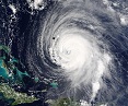
I've been away for a few days but see the NE Caribbean did end up getting whacked, I suspect now the Outer Banks at the very least have a pretty wild day when it comes close, but wouldn't shock me to see its western core actually hit.
Also ECM id an exceptional job on he strength forecast progging 932mbs for right now which looks nearly spot on, though the track forecast wasn't as good, highly unusual for it to be that way round!