ATL : INVEST 90L
Moderator: S2k Moderators
-
JonathanBelles
- Professional-Met

- Posts: 11430
- Age: 35
- Joined: Sat Dec 24, 2005 9:00 pm
- Location: School: Florida State University (Tallahassee, FL) Home: St. Petersburg, Florida
- Contact:
Thanks for bringing that to my attention HURAKAN. This looks like a relocation to the west of the old low. The NASA GHCC loop shows it very well. I did not expect this at all. Should be quite close to the Gulf Stream now. Tonight and tomorrow may be very interesting. I wish we had visible loops to examine.
0 likes
Re: ATL : INVEST 90L
There is some warm water out there, I wish station 41002 was operational.
Code: Select all
ID      T1 TIME    LAT     LON DIST HDG WDIR  WSPD   GST  WVHT   DPD   APD MWD   PRES  PTDY  ATMP  WTMP
           (GMT)                 nm  °T   °T   kts   kts    ft   sec   sec  °T     in    in    °F    °F
-------------------------------------------------------------------------------------------------------
SHIP     S 0600  33.20  -75.80   56 343   70  18.1     -     -     -     -   -  29.80 +0.00  73.4  80.6
0 likes


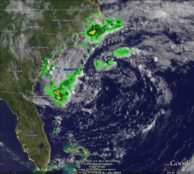
Very interesting looking system this morning it has to be said, the gulf stream has once again done the trick and lapse rates have increased again. I'd certainly say risk has increased now upto 40-50% but despite greater convection the overall state of the system remains the same as always, with only a small quadrant of the overall low region having convection.
Still can't rule out Alex yet given that bursting occuring...will be a short lived system.
Still can't rule out Alex yet given that bursting occuring...will be a short lived system.
0 likes
Personal Forecast Disclaimer:
The posts in this forum are NOT official forecast and should not be used as such. They are just the opinion of the poster and may or may not be backed by sound meteorological data. They are NOT endorsed by any professional institution or storm2k.org. For official information, please refer to the NHC and NWS products
The posts in this forum are NOT official forecast and should not be used as such. They are just the opinion of the poster and may or may not be backed by sound meteorological data. They are NOT endorsed by any professional institution or storm2k.org. For official information, please refer to the NHC and NWS products
Re: ATL : INVEST 90L
The super dry air that has been inhibiting this system from the start has started to wash out http://www.ssd.noaa.gov/goes/east/eaus/flash-wv.html. May have a twenty hour window to do something before the front shoves it out.
0 likes
-
brunota2003

- S2K Supporter

- Posts: 9476
- Age: 35
- Joined: Sat Jul 30, 2005 9:56 pm
- Location: Stanton, KY...formerly Havelock, NC
- Contact:
-
tolakram
- Admin

- Posts: 20186
- Age: 62
- Joined: Sun Aug 27, 2006 8:23 pm
- Location: Florence, KY (name is Mark)
Re: ATL : INVEST 90L
So which model had this moving toward Georgia? 

Uploaded with ImageShack.us
Good write up over at wunderground: http://www.wunderground.com/blog/Weathe ... trynum=364

Uploaded with ImageShack.us
Good write up over at wunderground: http://www.wunderground.com/blog/Weathe ... trynum=364
0 likes
M a r k
- - - - -
Join us in chat: Storm2K Chatroom Invite. Android and IOS apps also available.
The posts in this forum are NOT official forecasts and should not be used as such. Posts are NOT endorsed by any professional institution or STORM2K.org. For official information and forecasts, please refer to NHC and NWS products.

-
HURAKAN

- Professional-Met
- Posts: 46084
- Age: 39
- Joined: Thu May 20, 2004 4:34 pm
- Location: Key West, FL
- Contact:

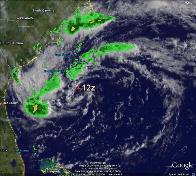
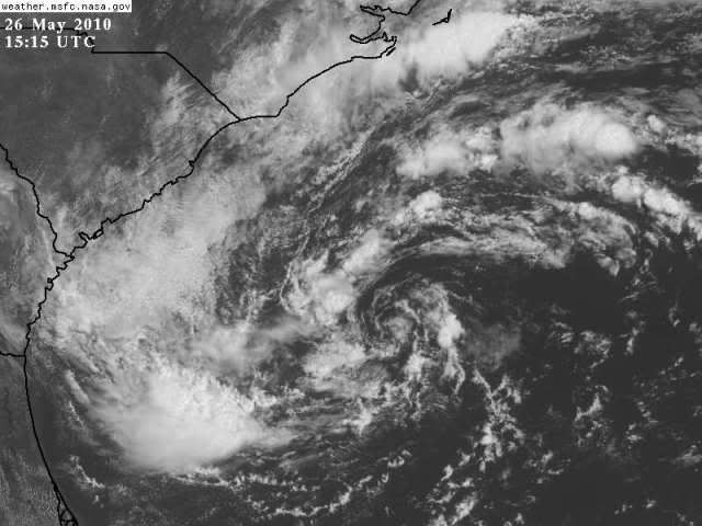
Finally, we seem to have a well-defined center of circulation
Loop - http://www.rap.ucar.edu/weather/satelli ... duration=2
The best it has ever looked
0 likes
Yeah itn does look better npw in terms of the circulation. I'd still want to see better convection closer to the systems center but I suppose there is an outside chance the NHC decide to go subtropical with this one soon, but I'd still think not...
0 likes
Personal Forecast Disclaimer:
The posts in this forum are NOT official forecast and should not be used as such. They are just the opinion of the poster and may or may not be backed by sound meteorological data. They are NOT endorsed by any professional institution or storm2k.org. For official information, please refer to the NHC and NWS products
The posts in this forum are NOT official forecast and should not be used as such. They are just the opinion of the poster and may or may not be backed by sound meteorological data. They are NOT endorsed by any professional institution or storm2k.org. For official information, please refer to the NHC and NWS products
-
Evil Jeremy

- S2K Supporter
- Posts: 5463
- Age: 32
- Joined: Mon Apr 10, 2006 2:10 pm
- Location: Los Angeles, CA
-
tolakram
- Admin
- Posts: 20186
- Age: 62
- Joined: Sun Aug 27, 2006 8:23 pm
- Location: Florence, KY (name is Mark)
Re: ATL : INVEST 90L
0 likes
M a r k
- - - - -
Join us in chat: Storm2K Chatroom Invite. Android and IOS apps also available.
The posts in this forum are NOT official forecasts and should not be used as such. Posts are NOT endorsed by any professional institution or STORM2K.org. For official information and forecasts, please refer to NHC and NWS products.
- - - - -
Join us in chat: Storm2K Chatroom Invite. Android and IOS apps also available.
The posts in this forum are NOT official forecasts and should not be used as such. Posts are NOT endorsed by any professional institution or STORM2K.org. For official information and forecasts, please refer to NHC and NWS products.
-
HURAKAN
- Professional-Met
- Posts: 46084
- Age: 39
- Joined: Thu May 20, 2004 4:34 pm
- Location: Key West, FL
- Contact:
Re: ATL : INVEST 90L
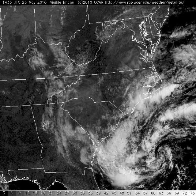
tolakram wrote:http://wwwghcc.msfc.nasa.gov/cgi-bin/get-goes?satellite=GOES-E%20CONUS&lat=30&lon=-65&info=vis&zoom=2&width=3000&height=2000&type=Animation&numframes=18
It appears the eastward movement has begun.
Yes, very slowly. Convection continues to build, although not much to fight for classification at this point, but lets see what it does in the next 24 hours. Certainly the best it has ever looked and the most organized it has ever been.
0 likes
-
HURAKAN
- Professional-Met
- Posts: 46084
- Age: 39
- Joined: Thu May 20, 2004 4:34 pm
- Location: Key West, FL
- Contact:
Re: ATL : INVEST 90L
GFS shear forecast:
time is definitely running out
Code: Select all
*   ATLANTIC SHIPS INTENSITY FORECAST       *
                    *      GOES DATA AVAILABLE                  *
                    *      OHC  DATA AVAILABLE                  *
                    *      INVEST  AL902010  05/26/10  12 UTC   *

TIME (HR)          0     6    12    18    24    36    48    60    72    84    96   108   120
SHEAR (KT)        13    14    19    17    13    32    32    51    56    72    66    53    57
time is definitely running out
0 likes

-
wxman57

- Moderator-Pro Met

- Posts: 23175
- Age: 68
- Joined: Sat Jun 21, 2003 8:06 pm
- Location: Houston, TX (southwest)
Re: ATL : INVEST 90L
Chances of it getting named are approaching zero now. Bones is approaching the microphone.
0 likes
Who is online
Users browsing this forum: No registered users and 36 guests