ATL: JULIA - Ex-TC - Discussion
Moderator: S2k Moderators
- expat2carib
- S2K Supporter

- Posts: 458
- Joined: Tue Jul 22, 2008 1:44 pm
- Location: Sint Maarten
Re: ATL: JULIA - Hurricane - Discussion
Oh ju.....ju....Julia. You have been such a nice lady to know. Showed the world your power. Decided to go out fishing while your big brother was stealing the show.
You didn't hurt anybody! You beauty!
Now you go under without a cry. Your big brother is taking you down.
Rest in peace......Dear Julia
You didn't hurt anybody! You beauty!
Now you go under without a cry. Your big brother is taking you down.
Rest in peace......Dear Julia
0 likes
- brunota2003
- S2K Supporter

- Posts: 9476
- Age: 35
- Joined: Sat Jul 30, 2005 9:56 pm
- Location: Stanton, KY...formerly Havelock, NC
- Contact:
Re: ATL: JULIA - Hurricane - Discussion
Well correct me if i'm wrong, but Julia did break or help break some records at least didn't she?
For one I believe She was the easternmost Category 4 hurricane ever on record in the Atlantic basin
Then I believe it was only the Second time in a hundred years that we had two Category 4 hurricanes in the Atlantic at the same time. (Julia and Igor)
Also its only happened 3 times in the last 60 years where we had 2 Majors (Cat 3 or higher) in the Atlantic at the same time.
So in my book I count Julia as an AWESOME hurricane. Was fun to track, broke records, out did the models, and didn't threaten a person. Julia Gulia is alright in my book
0 likes
2010 Archive: HURRICANE ALEX, TD TWO, TS BONNIE, TS COLIN, TD FIVE, HURRICANE DANIELLE, HURRICANE EARL, TS FIONA, TS GASTON, TS HERMINE, HURRICANE IGOR, HURRICANE JULIA, HURRICANE KARL, HURRICANE LISA, TS MATTHEW, TS NICOLE, HURRICANE OTTO, HURRICANE PAULA (Active)
-
hurricaneCW
- Category 5

- Posts: 1799
- Joined: Wed Mar 03, 2010 6:20 am
- Location: Toms River, NJ
Re: ATL: JULIA - Hurricane - Discussion
She's not dead yet, in fact she's looking better than before. She has a nice eye will colder cloud tops than before wrapping around it. I think she's stronger than initiated, so it will be interested if the NHC increases her intensity if she keeps this up.
0 likes
hurricaneCW she is holding her own no doubt.. But i woldn't expect her to get any further then the current Cat 1 status
0 likes
2010 Archive: HURRICANE ALEX, TD TWO, TS BONNIE, TS COLIN, TD FIVE, HURRICANE DANIELLE, HURRICANE EARL, TS FIONA, TS GASTON, TS HERMINE, HURRICANE IGOR, HURRICANE JULIA, HURRICANE KARL, HURRICANE LISA, TS MATTHEW, TS NICOLE, HURRICANE OTTO, HURRICANE PAULA (Active)
Re: ATL: JULIA - Hurricane - Discussion
LOL  I haven't noticed it but you're right she looks like a ? mark
0 likes
- Epsilon_Fan
- Category 1

- Posts: 353
- Joined: Fri Jan 13, 2006 1:03 pm
- Location: Charleston, SC
Re:
warmer wrote:what's my future, "?"
she looks a bit scared... I guess she'll close her eye before she takes the plunge. This is probably how we should remember her as she'll be torn up by tomorrow
0 likes
Re: ATL: JULIA - Hurricane - Discussion
She is getting warmer and warmer... So is it Igor doing her in? Or is it other factors?

I assume its got to be Igor.. You can see his extreme eastern outer bands right there on the Julia image

I assume its got to be Igor.. You can see his extreme eastern outer bands right there on the Julia image
0 likes
2010 Archive: HURRICANE ALEX, TD TWO, TS BONNIE, TS COLIN, TD FIVE, HURRICANE DANIELLE, HURRICANE EARL, TS FIONA, TS GASTON, TS HERMINE, HURRICANE IGOR, HURRICANE JULIA, HURRICANE KARL, HURRICANE LISA, TS MATTHEW, TS NICOLE, HURRICANE OTTO, HURRICANE PAULA (Active)
Re: ATL: JULIA - Hurricane - Discussion
woops.. 4:15am est and her eye has just slipped away.. It may be back, but at the moment it is MIA on the AVN (image was saved and uploaded via ImageShack so image would not change)


0 likes
2010 Archive: HURRICANE ALEX, TD TWO, TS BONNIE, TS COLIN, TD FIVE, HURRICANE DANIELLE, HURRICANE EARL, TS FIONA, TS GASTON, TS HERMINE, HURRICANE IGOR, HURRICANE JULIA, HURRICANE KARL, HURRICANE LISA, TS MATTHEW, TS NICOLE, HURRICANE OTTO, HURRICANE PAULA (Active)
Re: ATL: JULIA - Hurricane - Discussion
000
WTNT32 KNHC 170840
TCPAT2
BULLETIN
HURRICANE JULIA ADVISORY NUMBER 21
NWS TPC/NATIONAL HURRICANE CENTER MIAMI FL AL122010
500 AM AST FRI SEP 17 2010
...JULIA A LITTLE STRONGER...BUT EXPECTED TO WEAKEN LATER TODAY...
SUMMARY OF 500 AM AST...0900 UTC...INFORMATION
----------------------------------------------
LOCATION...23.8N 45.1W
ABOUT 1450 MI...2330 KM SW OF THE AZORES
MAXIMUM SUSTAINED WINDS...85 MPH...140 KM/HR
PRESENT MOVEMENT...WNW OR 290 DEGREES AT 24 MPH...39 KM/HR
MINIMUM CENTRAL PRESSURE...981 MB...28.97 INCHES
WATCHES AND WARNINGS
--------------------
THERE ARE NO COASTAL WATCHES OR WARNINGS IN EFFECT.
DISCUSSION AND 48-HOUR OUTLOOK
------------------------------
AT 500 AM AST...0900 UTC...THE CENTER OF HURRICANE JULIA WAS LOCATED
NEAR LATITUDE 23.8 NORTH...LONGITUDE 45.1 WEST. JULIA IS MOVING
TOWARD THE WEST-NORTHWEST NEAR 24 MPH...39 KM/HR. A TURN TOWARD THE
NORTHWEST WITH A DECREASE IN FORWARD SPEED ARE EXPECTED ON SATURDAY
...FOLLOWED BY A TURN TOWARD THE NORTH ON SUNDAY.
MAXIMUM SUSTAINED WINDS HAVE INCREASED TO NEAR 85 MPH...140 KM/HR
...WITH HIGHER GUSTS. JULIA IS A CATEGORY ONE HURRICANE ON THE
SAFFIR-SIMPSON HURRICANE WIND SCALE. WEAKENING IS ANTICIPATED
LATER TODAY AND SATURDAY.
HURRICANE FORCE WINDS EXTEND OUTWARD UP TO 35 MILES...55 KM...FROM
THE CENTER...AND TROPICAL STORM FORCE WINDS EXTEND OUTWARD UP TO 115
MILES...185 KM.
ESTIMATED MINIMUM CENTRAL PRESSURE IS 981 MB...28.97 INCHES.
HAZARDS AFFECTING LAND
----------------------
NONE.
NEXT ADVISORY
-------------
NEXT COMPLETE ADVISORY...1100 AM AST.
$$
FORECASTER BLAKE
0 likes
2010 Archive: HURRICANE ALEX, TD TWO, TS BONNIE, TS COLIN, TD FIVE, HURRICANE DANIELLE, HURRICANE EARL, TS FIONA, TS GASTON, TS HERMINE, HURRICANE IGOR, HURRICANE JULIA, HURRICANE KARL, HURRICANE LISA, TS MATTHEW, TS NICOLE, HURRICANE OTTO, HURRICANE PAULA (Active)
Re: ATL: JULIA - Hurricane - Discussion
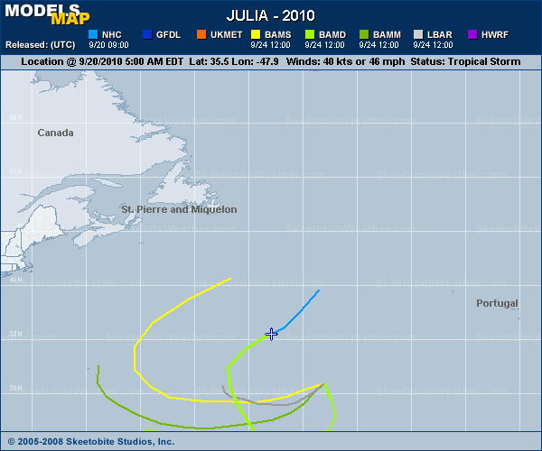
Whats with the MOdels going haywire with Julia towards the ends of the runs here? Is that due to Igor interaction?


0 likes
2010 Archive: HURRICANE ALEX, TD TWO, TS BONNIE, TS COLIN, TD FIVE, HURRICANE DANIELLE, HURRICANE EARL, TS FIONA, TS GASTON, TS HERMINE, HURRICANE IGOR, HURRICANE JULIA, HURRICANE KARL, HURRICANE LISA, TS MATTHEW, TS NICOLE, HURRICANE OTTO, HURRICANE PAULA (Active)
- Hurricanewatcher2007
- Category 2

- Posts: 578
- Joined: Sat Jul 05, 2008 8:10 pm
Re: ATL: JULIA - Hurricane - Discussion
Chances are the only ineraction between Igor and Julia that will take place is Igor absorbing her. Julia doesn't stand a chance against Igor!
0 likes
Re: ATL: JULIA - Hurricane - Discussion
Poor girl no longer looks like a hurricane thats for sure... RIP...


0 likes
2010 Archive: HURRICANE ALEX, TD TWO, TS BONNIE, TS COLIN, TD FIVE, HURRICANE DANIELLE, HURRICANE EARL, TS FIONA, TS GASTON, TS HERMINE, HURRICANE IGOR, HURRICANE JULIA, HURRICANE KARL, HURRICANE LISA, TS MATTHEW, TS NICOLE, HURRICANE OTTO, HURRICANE PAULA (Active)
Julia is smashing right into Igor's outer circulation and outflow, and so is getting sheared already and thats only going to get worse, will probably end up as just a secondary feature to Igor soon.
Also yeah Julia was cool, the way it bombed suddenly was pretty impressive!
Also yeah Julia was cool, the way it bombed suddenly was pretty impressive!
0 likes
Personal Forecast Disclaimer:
The posts in this forum are NOT official forecast and should not be used as such. They are just the opinion of the poster and may or may not be backed by sound meteorological data. They are NOT endorsed by any professional institution or storm2k.org. For official information, please refer to the NHC and NWS products
The posts in this forum are NOT official forecast and should not be used as such. They are just the opinion of the poster and may or may not be backed by sound meteorological data. They are NOT endorsed by any professional institution or storm2k.org. For official information, please refer to the NHC and NWS products
Who is online
Users browsing this forum: No registered users and 15 guests


