ATL: EX-Tropical Depression FIVE - Discussion
Moderator: S2k Moderators

Yeah it did form further west then where 94L is...I'm struggling to find many systems though that have formed where this one has and moved WNW/NW...I'm sure there must be some out there. Abby from 64 is one, Edouard isn't a bad match but a little too far north to start, whilst Alicia is as you say further west.
0 likes
Personal Forecast Disclaimer:
The posts in this forum are NOT official forecast and should not be used as such. They are just the opinion of the poster and may or may not be backed by sound meteorological data. They are NOT endorsed by any professional institution or storm2k.org. For official information, please refer to the NHC and NWS products
The posts in this forum are NOT official forecast and should not be used as such. They are just the opinion of the poster and may or may not be backed by sound meteorological data. They are NOT endorsed by any professional institution or storm2k.org. For official information, please refer to the NHC and NWS products

Re: ATL: INVEST 94L - Discussion
The ULL is forecast to move rapidly west and align right over the top of the low pressure in 12-18 hrs according to the GFS. Both the NAM and GFS forecast the ULL to rapidly move off to the SW GOM by 36 hrs. After that time, both the NAM and GFS forecast an upper level anticyclone to form along the northern gulf coast and essentially provide very favorable conditions for development from about 48 hrs onward. I wouldn't look for any strong development until that time.
0 likes
-
ColinDelia

- S2K Supporter

- Posts: 918
- Joined: Mon Aug 29, 2005 5:52 am
- Location: The Beach, FL
Re:
KWT wrote:Yeah it did form further west then where 94L is...I'm struggling to find many systems though that have formed where this one has and moved WNW/NW...I'm sure there must be some out there. Abby from 64 is one, Edouard isn't a bad match but a little too far north to start, whilst Alicia is as you say further west.
The 1856 Last Island Hurricane. There's a book out on it that is a good read.
"Island In a Storm"
0 likes
-
ColinDelia
- S2K Supporter
- Posts: 918
- Joined: Mon Aug 29, 2005 5:52 am
- Location: The Beach, FL
Re: Re:
ColinDelia wrote:KWT wrote:Yeah it did form further west then where 94L is...I'm struggling to find many systems though that have formed where this one has and moved WNW/NW...I'm sure there must be some out there. Abby from 64 is one, Edouard isn't a bad match but a little too far north to start, whilst Alicia is as you say further west.
The 1856 Last Island Hurricane. There's a book out on it that is a good read.
"Island In a Storm"
Scratch that. It was already a hurricane when first detected near key west. But an interesting storm anyway
0 likes
-
cycloneye

- Admin

- Posts: 149592
- Age: 69
- Joined: Thu Oct 10, 2002 10:54 am
- Location: San Juan, Puerto Rico
Re: ATL: INVEST 94L - Discussion
Code Red 60%
TWOAT
TROPICAL WEATHER OUTLOOK
NWS TPC/NATIONAL HURRICANE CENTER MIAMI FL
800 AM EDT TUE AUG 10 2010
FOR THE NORTH ATLANTIC...CARIBBEAN SEA AND THE GULF OF MEXICO...
SATELLITE IMAGES INDICATE THAT THE SHOWER AND THUNDERSTORM ACTIVITY
ASSOCIATED WITH A LOW PRESSURE SYSTEM LOCATED ABOUT 820 MILES
EAST-NORTHEAST OF THE LEEWARDS ISLANDS HAS NOT BECOME ANY BETTER
ORGANIZED SINCE YESTERDAY. THE LOW HAS SLOWED DOWN AND IS EXPECTED
TO MOVE NORTH-NORTHWESTWARD OR NORTHWARD TOWARD AN ENVIRONMENT A
LITTLE LESS FAVORABLE FOR DEVELOPMENT. HOWEVER... THERE IS STILL A
HIGH CHANCE...60 PERCENT...OF THIS SYSTEM BECOMING A TROPICAL
CYCLONE DURING THE NEXT 48 HOURS.
A LOW PRESSURE SYSTEM LOCATED OVER THE SOUTHEASTERN GULF OF
MEXICO...A LITTLE LESS THAN 100 MILES WEST OF SOUTHWEST COAST OF
THE FLORIDA PENINSULA...IS ACCOMPANIED BY A LARGE AREA OF SHOWERS
AND SQUALLS. ALTHOUGH THERE HAS BEEN LITTLE CHANGE IN ORGANIZATION
DURING THE PAST SEVERAL HOURS...UPPER-LEVEL WINDS ARE FORECAST TO
BECOME A LITTLE MORE CONDUCIVE FOR DEVELOPMENT. THERE IS A HIGH
CHANCE...60 PERCENT...OF THIS SYSTEM BECOMING A TROPICAL OR
SUBTROPICAL CYCLONE DURING THE NEXT 48 HOURS AS THE LOW MOVES
WEST-NORTHWESTWARD AT 5 TO 10 MPH.
ELSEWHERE...TROPICAL CYCLONE FORMATION IS NOT EXPECTED DURING THE
NEXT 48 HOURS.
$$
FORECASTER AVILA
0 likes
Visit the Caribbean-Central America Weather Thread where you can find at first post web cams,radars
and observations from Caribbean basin members Click Here
and observations from Caribbean basin members Click Here
-
DTWright

- Tropical Low

- Posts: 37
- Age: 66
- Joined: Sun Jun 27, 2010 4:48 pm
- Location: ( AKA Sabanic ) Mobile, AL
- Contact:
Re: ATL: INVEST 94L - Discussion
Going to be some very interesting next few days ahead for all along the Gulf Coast
0 likes
-
wxman57

- Moderator-Pro Met

- Posts: 23175
- Age: 68
- Joined: Sat Jun 21, 2003 8:06 pm
- Location: Houston, TX (southwest)
Re:
KWT wrote:Wxman57, what do you think in terms of possible strength at landfall given its going to have at least another 2-3 days over water?
We did a study on Gulf-developing storms/hurricanes and found that of about 105 such Gulf developers over the past 60 years that developed with 48 hours prior to landfall, about half developed into hurricanes. This one could fit into that study, as I think it'll be a TD today and have another 48 hours before moving inland. As I think development chances look to be about 100% now, then climo says 50% chance of a hurricane. Given the relatively low shear predicted and warm water, the actual chances may be higher than climo.
0 likes
I'm guessing recon is still flying out given its now a Code Red...
Makes sense to give code red given most models do develop the system...the ULL really is going to be key to the evolution of this system thats for sure!
Cheers Wxman57, love those sorts of stats...
Makes sense to give code red given most models do develop the system...the ULL really is going to be key to the evolution of this system thats for sure!
Cheers Wxman57, love those sorts of stats...
0 likes
Personal Forecast Disclaimer:
The posts in this forum are NOT official forecast and should not be used as such. They are just the opinion of the poster and may or may not be backed by sound meteorological data. They are NOT endorsed by any professional institution or storm2k.org. For official information, please refer to the NHC and NWS products
The posts in this forum are NOT official forecast and should not be used as such. They are just the opinion of the poster and may or may not be backed by sound meteorological data. They are NOT endorsed by any professional institution or storm2k.org. For official information, please refer to the NHC and NWS products
-
gboudx

- S2K Supporter
- Posts: 4090
- Joined: Thu Sep 04, 2003 1:39 pm
- Location: Rockwall, Tx but from Harvey, La
jeff's update. Graphic excepted.
Area of disturbed weather in the SE Gulf of Mexico is becoming better organized.
Discussion:
Broad area of surface low pressure has formed over the SE Gulf of Mexico roughly 80 miles SW of Naples, FL based on surface observations from ships, buoys, and coastal land stations as well as radar data out of Tampa and Key West. Surface pressures have begun to slowly fall in the last 24 hours with the eastern Gulf NCDC buoy 42003 falling from 29.90in to 29.84in in the last 24 hours. Both radar and satellite data show nearly all of the thunderstorm activity on the southern side of the broad low pressure area as 10-15kts of northerly shear are affecting he system with dry air to its north. Recent radar data from Key West shows a decent convective band extending along most of the FL Keys and then westward into the Gulf for several hundred miles.
Track:
94L is in a very weak steering environment with high pressure over the southern US providing a weak W to WSW motion at the moment. Strong high pressure is over TX with a weakness in the ridge over the middle Gulf coast region. Global forecast models take 94L toward the WNW to NW toward the middle Gulf coast over the next 48-72 hours. The GFDL, HWRF, and CMC all show a general WNW to NW track toward SE LA while the GFS has just recently shown a more westward track toward SW LA in its latest 06Z run overnight. Models are in decent agreement and are fairly tightly clustered on the idea of 94L tracking toward the weakness over the middle Gulf coast states. Only concern I have at the moment is potential for center reformations to the S and W due to light northerly wind shear and the current displacement of the strong convective clusters…this can sometimes help the low level circulation reform closer to the intense convection. Such events in this same area include Katrina when she was in her formative stage with a very strong southern convective band which tended to pull the center SW with time after departing S FL.
Intensity:
As seems to be the case so far this season, model support for the development of 94L is minimal at best. The EURO shows little to no development along with a weak reflection in the GFS. The GFDL is most aggressive taking 94L toward a strong TS or weak hurricane near landfall and the HWRF shows a weak TS. Environmental factors are not ideal at the moment for intensification with weak northerly wind shear and dry air covering much of the northern and northeastern Gulf. However upper level winds are forecast to improve and 94L will be moving over very warm SST’s at a fairly slow rate. It is very possible that 94L does not really get going until closer to landfall as suggested by the GFDL. Since the surface low is fairly large, slow intensification is most likely until an inner core is able to form.
Local Weather:
Higher moisture over LA will be pushing west today and is already noted with scattered offshore T-storms this morning. PW values rise into the 2.0-2.3 inch range, however subsidence from the ridge aloft will continue to fight against widespread rainfall. With that said will likely see more coverage than yesterday along the local seabreeze and baybreeze.
Moisture really begins to ramp up Thursday into next weekend as 94L (or something more) approaches LA and mid level inverted trough crosses SE TX and finally helps to break down the subsidence of the ridge. For now will keep most impacts of potential Gulf tropical cyclone just east of our region except for a potential backing of the surface winds to NE on the west side of any circulation and possible higher seas. Combination of increased moisture from passage on the trough around Friday should result in fairly decent coverage of thunderstorms Friday and Saturday especially across our eastern counties. Or course any deviation of the Gulf system slightly westward would bring significant changes to SE TX forecasts.
0 likes
-
thetruesms

- Professional-Met

- Posts: 844
- Age: 42
- Joined: Thu Aug 16, 2007 1:14 pm
- Location: Tallahasee, FL
- Contact:
Wow, this time yesterday I was leaning against something really coming out of this, and now 24 hours later, I can't really find any reason at all why it won't. With the environment it's in, the position/strength/movement of the low to the northeast, and the organization evident so far, it really looks like just a matter of time.
Given the way this season has gone so far, that means it's time for something to happen and disrupt everything
Given the way this season has gone so far, that means it's time for something to happen and disrupt everything
0 likes
I'm not sure how well models handle these messy types of systems that are sorta hybrid, not sure we can have as much confidence in the models as normal.
Anyway it does look like its going to have a good shot at developing, I personally don't think we will see anything too impressive, maybe something of a similar strength and location to Edouard in 2008?
Anyway it does look like its going to have a good shot at developing, I personally don't think we will see anything too impressive, maybe something of a similar strength and location to Edouard in 2008?
0 likes
Personal Forecast Disclaimer:
The posts in this forum are NOT official forecast and should not be used as such. They are just the opinion of the poster and may or may not be backed by sound meteorological data. They are NOT endorsed by any professional institution or storm2k.org. For official information, please refer to the NHC and NWS products
The posts in this forum are NOT official forecast and should not be used as such. They are just the opinion of the poster and may or may not be backed by sound meteorological data. They are NOT endorsed by any professional institution or storm2k.org. For official information, please refer to the NHC and NWS products
-
WX5DBZ

- Professional-Met
- Posts: 15
- Age: 39
- Joined: Mon Aug 09, 2010 1:51 pm
- Location: Lubbock, TX via Fairbanks, AK via Ocean Springs, MS
- Contact:
Re:
thetruesms wrote:Wow, this time yesterday I was leaning against something really coming out of this, and now 24 hours later, I can't really find any reason at all why it won't. With the environment it's in, the position/strength/movement of the low to the northeast, and the organization evident so far, it really looks like just a matter of time.
Given the way this season has gone so far, that means it's time for something to happen and disrupt everything
I would agree with you
0 likes
Charles Aldrich
Meteorologist
**The opinions expressed are mine alone and do not necessarily represent those of my employer.**
Meteorologist
**The opinions expressed are mine alone and do not necessarily represent those of my employer.**
-
Air Force Met
- Military Met

- Posts: 4372
- Age: 57
- Joined: Tue Jul 08, 2003 9:30 am
- Location: Roan Mountain, TN
Re: Re:
wxman57 wrote:KWT wrote:Wxman57, what do you think in terms of possible strength at landfall given its going to have at least another 2-3 days over water?
We did a study on Gulf-developing storms/hurricanes and found that of about 105 such Gulf developers over the past 60 years that developed with 48 hours prior to landfall, about half developed into hurricanes. This one could fit into that study, as I think it'll be a TD today and have another 48 hours before moving inland. As I think development chances look to be about 100% now, then climo says 50% chance of a hurricane. Given the relatively low shear predicted and warm water, the actual chances may be higher than climo.
Given the slow movement...there is a decent shot at weak cat 1 status. I think TD status won't be until sometime tomorrow...but that should still give it plenty of time.
When they pull the trigger on TD status will depend on what criteria they are using and if they think it is organized enough. I imagine that will happen sometime tomorrow after the upper low moves away..
0 likes

-
PTrackerLA

- Category 5

- Posts: 5281
- Age: 42
- Joined: Thu Oct 10, 2002 8:40 pm
- Location: Lafayette, LA
Re: ATL: INVEST 94L - Discussion
Looking at the first visible shots this morning, I really don't see how this doesn't become a TD today. Quite a large circulation has developed as well, we really need to watch this one.
0 likes
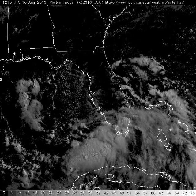
That Vis.imagery is very interesting, sure does look like a system is developing, I'd up this now to 70-80%.
The fact so many mets agree on what may happen, I think its safe to assume we have a player here...
The fact so many mets agree on what may happen, I think its safe to assume we have a player here...
0 likes
Personal Forecast Disclaimer:
The posts in this forum are NOT official forecast and should not be used as such. They are just the opinion of the poster and may or may not be backed by sound meteorological data. They are NOT endorsed by any professional institution or storm2k.org. For official information, please refer to the NHC and NWS products
The posts in this forum are NOT official forecast and should not be used as such. They are just the opinion of the poster and may or may not be backed by sound meteorological data. They are NOT endorsed by any professional institution or storm2k.org. For official information, please refer to the NHC and NWS products


Re: ATL: INVEST 94L - Discussion
Seems like the center may be forming under that deep convection west of Key West this morning.
http://radar.weather.gov/radar.php?product=N0Z&rid=BYX&loop=yes
http://radar.weather.gov/radar.php?product=N0Z&rid=BYX&loop=yes
0 likes
Who is online
Users browsing this forum: No registered users and 35 guests