ATL: OTTO - Post-tropical - Discussion
Moderator: S2k Moderators

Yeah I think it'll stick at 80% with similar wording to before with a chance that it is tropical/subtropical still....though I personaly think STS is the way this one will go.
0 likes
Personal Forecast Disclaimer:
The posts in this forum are NOT official forecast and should not be used as such. They are just the opinion of the poster and may or may not be backed by sound meteorological data. They are NOT endorsed by any professional institution or storm2k.org. For official information, please refer to the NHC and NWS products
The posts in this forum are NOT official forecast and should not be used as such. They are just the opinion of the poster and may or may not be backed by sound meteorological data. They are NOT endorsed by any professional institution or storm2k.org. For official information, please refer to the NHC and NWS products
-
bvigal

- S2K Supporter

- Posts: 2276
- Joined: Sun Jul 24, 2005 8:49 am
- Location: British Virgin Islands
- Contact:
Re: ATL: INVEST 97L - Discussion - (Code Red)
Well that's it for me. The rain has stopped for now, frogs are chirping. Wind is still gusty, but not as strong as earlier, I can hear the tv... It's time for Dancing With The Stars results show! Stay safe, all my neighbors!
0 likes
-
BatzVI

- Tropical Storm

- Posts: 199
- Joined: Sat Jun 10, 2006 8:27 am
- Location: St. Thomas, Virgin Islands
Re: ATL: INVEST 97L - Discussion - (Code Red)
Sure wish the rain would stop here...been terrible today...I don't know how much we got here in St. Thomas, but has to be a lot...and to top it off, our cable's out again...the joys of island living...
0 likes
-
wxman57

- Moderator-Pro Met

- Posts: 23175
- Age: 68
- Joined: Sat Jun 21, 2003 8:06 pm
- Location: Houston, TX (southwest)
Re:
KWT wrote:Yeah its clearly producing alot of moisture but I'd be very amazed to see it getting called a pure tropical storm, it looks like a subtropical low, esp the linear nature of the convection. Still its a big ole region of convection and there probably is a little while left till we shunt the rain out of the way...
I agree, it isn't a "tropical storm" in terms of its structure. It would start out subtropical but it could transform into a tropical cyclone in a few days, possibly even a hurricane.
0 likes

Re: ATL: INVEST 97L - Discussion - (Code Red)
Take a look at this and you will see some similarities with 97L, the upper low and the convection to the east seems to be wrapping around each other:
Subtropical Storm Andrea:
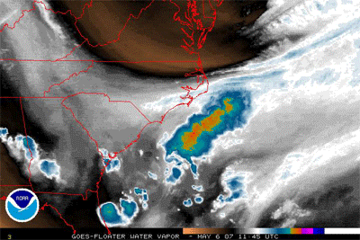
Subtropical Storm Andrea:
0 likes
-
cycloneye

- Admin

- Posts: 149585
- Age: 69
- Joined: Thu Oct 10, 2002 10:54 am
- Location: San Juan, Puerto Rico
Re: ATL: INVEST 97L - Discussion - (Code Red)
00z Best Track
AL, 97, 2010100600, , BEST, 0, 215N, 661W, 30, 1002, LO
ftp://ftp.tpc.ncep.noaa.gov/atcf/tcweb/ ... 010.invest
AL, 97, 2010100600, , BEST, 0, 215N, 661W, 30, 1002, LO
ftp://ftp.tpc.ncep.noaa.gov/atcf/tcweb/ ... 010.invest
0 likes
Visit the Caribbean-Central America Weather Thread where you can find at first post web cams,radars
and observations from Caribbean basin members Click Here
and observations from Caribbean basin members Click Here


-
bvigal
- S2K Supporter
- Posts: 2276
- Joined: Sun Jul 24, 2005 8:49 am
- Location: British Virgin Islands
- Contact:
Re: ATL: INVEST 97L - Discussion - (Code Red)
Some actual wind gusts measured by ground stations last 12hrs.
LTBV3 St. Croix 2124z wind 35.0kt gust 48.0kt
CHAV3 St. Thomas 1312z wind 7.0kt gust 45.1kt
CHAV3 St. Thomas 1306z wind 9.9kt gust 45.1kt
SRBV3 St. Croix 2200z wind 15.9kt gust 38.1kt
These are all at sea level.
Our airport closed at 7:15pm due to winds near tropical storm force.
LTBV3 St. Croix 2124z wind 35.0kt gust 48.0kt
CHAV3 St. Thomas 1312z wind 7.0kt gust 45.1kt
CHAV3 St. Thomas 1306z wind 9.9kt gust 45.1kt
SRBV3 St. Croix 2200z wind 15.9kt gust 38.1kt
These are all at sea level.
Our airport closed at 7:15pm due to winds near tropical storm force.
0 likes

-
Weatherfreak000
-
Brent
- S2K Supporter
- Posts: 38765
- Age: 37
- Joined: Sun May 16, 2004 10:30 pm
- Location: Tulsa Oklahoma
- Contact:
Re: ATL: INVEST 97L - Discussion - (Code Red)
TROPICAL WEATHER OUTLOOK
NWS TPC/NATIONAL HURRICANE CENTER MIAMI FL
200 AM EDT WED OCT 6 2010
FOR THE NORTH ATLANTIC...CARIBBEAN SEA AND THE GULF OF MEXICO...
SHOWERS AND THUNDERSTORMS ASSOCIATED WITH A LOW PRESSURE AREA
CENTERED ABOUT 235 MILES NORTH-NORTHWEST OF SAN JUAN PUERTO RICO
HAVE BECOME BETTER ORGANIZED DURING THE PAST FEW HOURS. ONLY A
SMALL INCREASE IN THE ORGANIZATION OF THIS SYSTEM WOULD RESULT IN
THE FORMATION OF A SUBTROPICAL OR TROPICAL CYCLONE LATER TODAY.
THERE IS A HIGH CHANCE...90 PERCENT...OF THIS SYSTEM BECOMING A
SUBTROPICAL OR TROPICAL CYCLONE DURING THE NEXT 48 HOURS AS IT
MOVES NORTHWESTWARD AT 10 MPH. LOCALLY HEAVY RAINS AND GUSTY WINDS
WILL LIKELY CONTINUE OVER THE LEEWARD ISLANDS...THE VIRGIN
ISLANDS...AND PUERTO RICO DURING THE NEXT DAY OR TWO.
ELSEWHERE...TROPICAL CYCLONE FORMATION IS NOT EXPECTED DURING THE
NEXT 48 HOURS.
$$
FORECASTER BLAKE
0 likes
#neversummer
-
dwsqos2
Re: ATL: INVEST 97L - Discussion - (Code Red)
I hate these systems. There is little more tropicallly frustrating than waiting to see if the convective definition will ever be satisfied.
The 0Z Euro was fairly robust; it deepens 97L to 992 mb by hour 24 and 988 mb by hour 48. The 0Z gfs was a hair weaker than the 18Z run. I would post this in the model thread, but it doesn't seem necessary to make a new post. I have no idea if the Euro is realistic; I would guess that it is not. 97L still looks a bit of mess as of 0545Z.
The 0Z Euro was fairly robust; it deepens 97L to 992 mb by hour 24 and 988 mb by hour 48. The 0Z gfs was a hair weaker than the 18Z run. I would post this in the model thread, but it doesn't seem necessary to make a new post. I have no idea if the Euro is realistic; I would guess that it is not. 97L still looks a bit of mess as of 0545Z.
0 likes
-
Ad Novoxium
- Category 1

- Posts: 348
- Age: 35
- Joined: Sat May 03, 2008 2:12 am
Re: ATL: INVEST 97L - Discussion - (Code Red)
We have Subtropical Depression 17:
000
WTNT32 KNHC 060837
TCPAT2
BULLETIN
SUBTROPICAL DEPRESSION SEVENTEEN ADVISORY NUMBER 1
NWS TPC/NATIONAL HURRICANE CENTER MIAMI FL AL172010
500 AM AST WED OCT 06 2010
...SUBTROPICAL DEPRESSION FORMS OVER THE WESTERN ATLANTIC OCEAN...
SUMMARY OF 500 AM AST...0900 UTC...INFORMATION
----------------------------------------------
LOCATION...22.2N 67.0W
ABOUT 270 MI...435 KM NNW OF SAN JUAN PUERTO RICO
ABOUT 710 MI...1145 KM S OF BERMUDA
MAXIMUM SUSTAINED WINDS...35 MPH...55 KM/HR
PRESENT MOVEMENT...NW OR 325 DEGREES AT 8 MPH...13 KM/HR
MINIMUM CENTRAL PRESSURE...1001 MB...29.56 INCHES
WATCHES AND WARNINGS
--------------------
THERE ARE NO COASTAL WATCHES OR WARNINGS IN EFFECT.
DISCUSSION AND 48-HOUR OUTLOOK
------------------------------
AT 500 AM AST...0900 UTC...THE CENTER OF SUBTROPICAL DEPRESSION
SEVENTEEN WAS LOCATED NEAR LATITUDE 22.2 NORTH...LONGITUDE 67.0
WEST. THE DEPRESSION IS MOVING TOWARD THE NORTHWEST NEAR 8 MPH...13
KM/HR. A TURN TOWARD THE NORTH-NORTHWEST AND A DECREASE IN FORWARD
SPEED ARE EXPECTED BY LATE TONIGHT. A TURN TOWARD THE NORTHEAST
AND AN INCREASE IN FORWARD SPEED ARE FORECAST ON FRIDAY.
MAXIMUM SUSTAINED WINDS ARE NEAR 35 MPH...55 KM/HR...WITH HIGHER
GUSTS. SLOW STRENGTHENING IS FORECAST DURING THE NEXT 48 HOURS AND
THE SYSTEM COULD BECOME A TROPICAL OR SUBTROPICAL STORM LATER
TODAY.
SURFACE OBSERVATIONS FROM NOAA BUOY 41043 SUGGEST THAT THE MINIMUM
CENTRAL PRESSURE IS ABOUT 1001 MB...29.56 INCHES.
HAZARDS AFFECTING LAND
----------------------
RAINFALL...ADDITIONAL HEAVY RAINFALL IS POSSIBLE IN THE NORTHERN
LEEWARD ISLANDS AND PUERTO RICO DURING THE NEXT DAY OR SO.
NEXT ADVISORY
-------------
NEXT COMPLETE ADVISORY...1100 AM AST.
$$
FORECASTER BLAKE
0 likes


-
DanKellFla

- Category 5

- Posts: 1291
- Joined: Fri Mar 17, 2006 12:02 pm
- Location: Lake Worth, Florida
Re: ATL: SUBTROPICAL DEPRESSION 17 - Discussion
Well, it is officially subtropical.
TNT42 KNHC 060837
TCDAT2
SUBTROPICAL DEPRESSION SEVENTEEN DISCUSSION NUMBER 1
NWS TPC/NATIONAL HURRICANE CENTER MIAMI FL AL172010
500 AM AST WED OCT 06 2010
SATELLITE IMAGES INDICATE THAT THE AREA OF LOW PRESSURE NORTH OF
PUERTO RICO HAS DEVELOPED BANDS OF DEEP AND CURVED CONVECTION IN
THE NORTHERN AND EASTERN QUADRANTS. IN ADDITION...NIGHT VISIBLE
IMAGES SUGGEST THAT THE CENTER HAS BECOME BETTER-DEFINED SINCE
YESTERDAY. SATELLITE CLASSIFICATIONS ARE A TROPICAL 2.0 FROM
TAFB...AND A SUBTROPICAL 1.5 FROM TAFB. WHILE THE LOW IS NOT FAR
FROM BEING MORE TROPICAL THAN SUBTROPICAL...ITS CURRENT LARGE
RADIUS OF MAXIMUM WINDS...AT LEAST 120 N MI...AND ITS ENTANGLEMENT
WITH AN UPPER LOW LEAD ME TO START THE SYSTEM AS A SUBTROPICAL
DEPRESSION. THE INITIAL WINDS ARE SET TO 30 KT...IN AGREEMENT WITH
A FEW SHIP AND BUOY OBSERVATIONS DURING THE PAST SEVERAL HOURS.
0 likes
-
cycloneye
- Admin
- Posts: 149585
- Age: 69
- Joined: Thu Oct 10, 2002 10:54 am
- Location: San Juan, Puerto Rico
Re: ATL: INVEST 97L - Discussion - (Code Red)
BatzVI wrote:Sure wish the rain would stop here...been terrible today...I don't know how much we got here in St. Thomas, but has to be a lot...and to top it off, our cable's out again...the joys of island living...
The NWS of San Juan released this morning this statement concerning the rainfall totals so far in ST Thomas.
.CLIMATE....AS OF MIDNIGHT AST ON 5 OCT 2010...6.61 INCHES OF
RAINFALL HAD ACCUMULATED AT THE SAINT THOMAS CYRIL E. KING
AIRPORT IN CHARLOTTE AMALIE...MAKING IT THE 5TH WETTEST DAY ON
SAINT THOMAS SINCE RECORD KEEPING BEGAN...AND THE WETTEST DAY
SINCE SEPTEMBER 15TH 2004 WHEN JEANNE TRACKED ACROSS THE LOCAL
ISLANDS
0 likes
Visit the Caribbean-Central America Weather Thread where you can find at first post web cams,radars
and observations from Caribbean basin members Click Here
and observations from Caribbean basin members Click Here
So its a STD 
It does look a little more tropical today in apperence but we'd probably need recon to make a visit to really know what state this system is in at the moment.
May well eventually become TS Otto but we will see...
It does look a little more tropical today in apperence but we'd probably need recon to make a visit to really know what state this system is in at the moment.
May well eventually become TS Otto but we will see...
0 likes
Personal Forecast Disclaimer:
The posts in this forum are NOT official forecast and should not be used as such. They are just the opinion of the poster and may or may not be backed by sound meteorological data. They are NOT endorsed by any professional institution or storm2k.org. For official information, please refer to the NHC and NWS products
The posts in this forum are NOT official forecast and should not be used as such. They are just the opinion of the poster and may or may not be backed by sound meteorological data. They are NOT endorsed by any professional institution or storm2k.org. For official information, please refer to the NHC and NWS products
-
wxman57
- Moderator-Pro Met
- Posts: 23175
- Age: 68
- Joined: Sat Jun 21, 2003 8:06 pm
- Location: Houston, TX (southwest)
Re: ATL: SUBTROPICAL DEPRESSION 17 - Discussion
With convection building around the center, I think it'll transition and become TS Otto later today. Once it accelerates out to sea to the NE, conditions across the NE Caribbean should improve somewhat. But low pressure will persist in the Caribbean after this storm moves out.
0 likes
Who is online
Users browsing this forum: No registered users and 62 guests