ATL: TROPICAL DEPRESSION ALEX - DISCUSSION
Moderator: S2k Moderators
-
cycloneye

- Admin

- Posts: 149572
- Age: 69
- Joined: Thu Oct 10, 2002 10:54 am
- Location: San Juan, Puerto Rico
Re: ATL: INVEST 93L - DISCUSSION
0 likes
Visit the Caribbean-Central America Weather Thread where you can find at first post web cams,radars
and observations from Caribbean basin members Click Here
and observations from Caribbean basin members Click Here
-
srainhoutx

- S2K Supporter

- Posts: 6919
- Age: 68
- Joined: Sun Jan 14, 2007 11:34 am
- Location: Haywood County, NC
- Contact:
Re: ATL: INVEST 93L - DISCUSSION
0 likes
Carla/Alicia/Jerry(In The Eye)/Michelle/Charley/Ivan/Dennis/Katrina/Rita/Wilma/Ike/Harvey
Member: National Weather Association
Wx Infinity Forums
http://wxinfinity.com/index.php
Facebook.com/WeatherInfinity
Twitter @WeatherInfinity
Member: National Weather Association
Wx Infinity Forums
http://wxinfinity.com/index.php
Facebook.com/WeatherInfinity
Twitter @WeatherInfinity
-
brunota2003

- S2K Supporter
- Posts: 9476
- Age: 35
- Joined: Sat Jul 30, 2005 9:56 pm
- Location: Stanton, KY...formerly Havelock, NC
- Contact:
Re: ATL: INVEST 93L - DISCUSSION
cycloneye wrote:WNW wind in Bonaire
Interesting...though it is only 5 mph, so it could be local effects. Would be nice to see a sat image with the surface obs/ships/buoys placed on them
0 likes
Re: ATL: INVEST 93L - DISCUSSION
Last edited by poof121 on Mon Jun 21, 2010 11:40 am, edited 1 time in total.
0 likes
-
Ivanhater

- Storm2k Moderator

- Posts: 11221
- Age: 39
- Joined: Fri Jul 01, 2005 8:25 am
- Location: Pensacola
Re: ATL: INVEST 93L - DISCUSSION
brunota2003 wrote:cycloneye wrote:WNW wind in Bonaire
Interesting...though it is only 5 mph, so it could be local effects. Would be nice to see a sat image with the surface obs/ships/buoys placed on them

0 likes
Michael
Re: ATL: INVEST 93L - DISCUSSION
Ivanhater wrote:brunota2003 wrote:cycloneye wrote:WNW wind in Bonaire
Interesting...though it is only 5 mph, so it could be local effects. Would be nice to see a sat image with the surface obs/ships/buoys placed on them
Yeah, from that pic, looks like the wind could be funneling through that inlet. Especially if there is high elevation on the smaller island.
0 likes

-
Rockin4NOLA

- Tropical Low

- Posts: 42
- Age: 36
- Joined: Sun Jun 20, 2010 9:44 pm
- Location: New Orleans, LA
Someone referenced the Sosnowski article so I thought I'd post that here (although I realize most of you have probably already read it...)
http://www.accuweather.com/blogs/news/s ... urrica.asp
I guess we are waiting to see where the ridge forms? If I understand correctly - if it forms more to the west, then 93L would take a more northerly GOM track, whereas if it forms more to the east, then 93L would track westwards?
http://www.accuweather.com/blogs/news/s ... urrica.asp
I guess we are waiting to see where the ridge forms? If I understand correctly - if it forms more to the west, then 93L would take a more northerly GOM track, whereas if it forms more to the east, then 93L would track westwards?
0 likes
Proud to call New Orleans home. NOLA forever.
-
Aquawind

- Category 5

- Posts: 6714
- Age: 62
- Joined: Mon Jun 16, 2003 10:41 pm
- Location: Salisbury, NC
- Contact:
Re: ATL: INVEST 93L - DISCUSSION
Ivanhater wrote:
That's a little more south like what I was thinking looking at the blob..
0 likes
-
srainhoutx
- S2K Supporter
- Posts: 6919
- Age: 68
- Joined: Sun Jan 14, 2007 11:34 am
- Location: Haywood County, NC
- Contact:
Re: ATL: INVEST 93L - DISCUSSION
0 likes
Carla/Alicia/Jerry(In The Eye)/Michelle/Charley/Ivan/Dennis/Katrina/Rita/Wilma/Ike/Harvey
Member: National Weather Association
Wx Infinity Forums
http://wxinfinity.com/index.php
Facebook.com/WeatherInfinity
Twitter @WeatherInfinity
Member: National Weather Association
Wx Infinity Forums
http://wxinfinity.com/index.php
Facebook.com/WeatherInfinity
Twitter @WeatherInfinity

Re: ATL: INVEST 93L - DISCUSSION
0 likes
-
thetruesms

- Professional-Met

- Posts: 844
- Age: 42
- Joined: Thu Aug 16, 2007 1:14 pm
- Location: Tallahasee, FL
- Contact:
yeah, this needs to just go ahead and poof for a bit. I need to get caught up after being out of the office for the last week and a half before I can start dealing with this stuff 
But without being able to comment on 92L since I was without internet access last week, it looks like it has the most potential of anything so far in this young season.
But without being able to comment on 92L since I was without internet access last week, it looks like it has the most potential of anything so far in this young season.
0 likes

Re: ATL: INVEST 93L - DISCUSSION
Ivanhater wrote:Wx_Warrior wrote:Yea, Ivanhater has been quick to jump this season. Remember 92L? LOL
Now if I remember from past seasons wxwarrior, I thought you were a Euro fan
Good to see you back buddy
Given the situation in the Gulf, I would not blame anyone along the coast for being nervous about any invest or potential issue for the GOM.
0 likes

-
Rockin4NOLA
- Tropical Low
- Posts: 42
- Age: 36
- Joined: Sun Jun 20, 2010 9:44 pm
- Location: New Orleans, LA
Re: ATL: INVEST 93L - DISCUSSION
Ivanhater wrote:
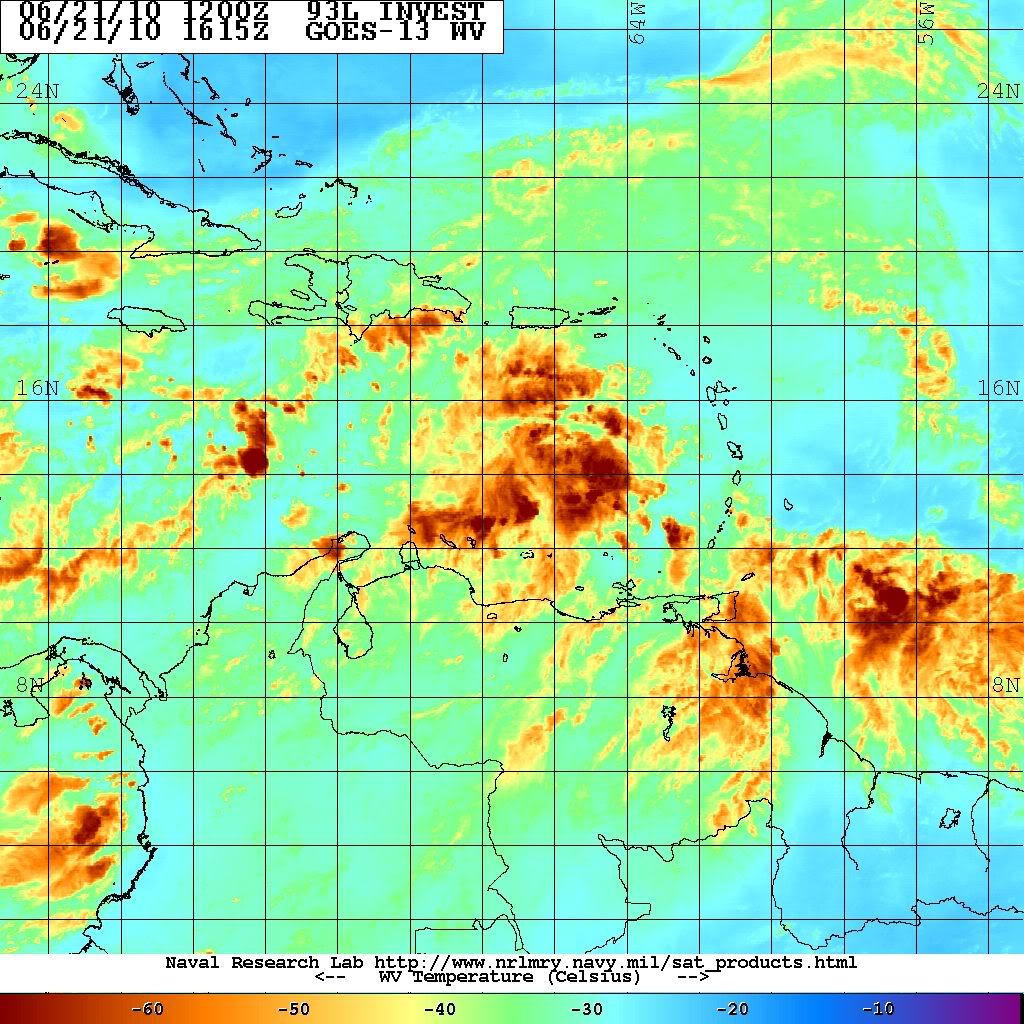
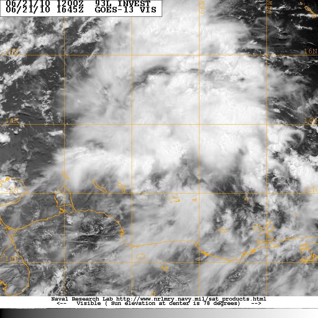
I don't know if I'm reading that image right but are those pockets of dry air to 93L's N/NW?...That storm looks like its got good structure...
0 likes
Proud to call New Orleans home. NOLA forever.

-
jasons2k

- Storm2k Executive
- Posts: 8290
- Age: 52
- Joined: Wed Jul 06, 2005 12:32 pm
- Location: The Woodlands, TX
Re: ATL: INVEST 93L - DISCUSSION
Rockin4NOLA wrote:
I don't know if I'm reading that image right but are those pockets of dry air to 93L's N/NW?...That storm looks like its got good structure...
Look at the WV image a few posts up.
Nice, big moisture envelope to work with. Dunno that I agree with the "Structure" comment though - after all, it's still an open wave. Not much structure to it yet.
That said, given time, I now do expect this one to develop. I don't see anything holding it back.
0 likes
-
cycloneye
- Admin
- Posts: 149572
- Age: 69
- Joined: Thu Oct 10, 2002 10:54 am
- Location: San Juan, Puerto Rico
Re: ATL: INVEST 93L - DISCUSSION
TROPICAL WEATHER OUTLOOK
NWS TPC/NATIONAL HURRICANE CENTER MIAMI FL
200 PM EDT MON JUN 21 2010
FOR THE NORTH ATLANTIC...CARIBBEAN SEA AND THE GULF OF MEXICO...
A LARGE AREA OF SHOWERS AND THUNDERSTORMS OVER THE EASTERN CARIBBEAN
SEA IS ASSOCIATED WITH A STRONG TROPICAL WAVE THAT IS MOVING
WESTWARD AT 10 TO 15 MPH. ALTHOUGH THERE IS NO EVIDENCE OF A
SURFACE CIRCULATION...THIS SYSTEM IS SHOWING SOME SIGNS OF
ORGANIZATION AND ENVIRONMENTAL CONDITIONS APPEAR CONDUCIVE FOR
GRADUAL DEVELOPMENT DURING THE NEXT COUPLE OF DAYS. THIS WAVE
COULD PRODUCE LOCALLY HEAVY RAINFALL AND GUSTY WINDS OVER PORTIONS
OF NORTHERN VENEZUELA...THE NETHERLANDS ANTILLES...PUERTO
RICO...THE DOMINICAN REPUBLIC...AND HAITI OVER THE NEXT DAY OR SO.
THERE IS A MEDIUM CHANCE...30 PERCENT...OF THIS SYSTEM BECOMING A
TROPICAL CYCLONE DURING THE NEXT 48 HOURS.
ELSEWHERE...TROPICAL CYCLONE FORMATION IS NOT EXPECTED DURING THE
NEXT 48 HOURS.
$$
FORECASTER BLAKE
0 likes
Visit the Caribbean-Central America Weather Thread where you can find at first post web cams,radars
and observations from Caribbean basin members Click Here
and observations from Caribbean basin members Click Here
-
Rockin4NOLA
- Tropical Low
- Posts: 42
- Age: 36
- Joined: Sun Jun 20, 2010 9:44 pm
- Location: New Orleans, LA
Re: ATL: INVEST 93L - DISCUSSION
jasons wrote:Rockin4NOLA wrote:
I don't know if I'm reading that image right but are those pockets of dry air to 93L's N/NW?...That storm looks like its got good structure...
Look at the WV image a few posts up.
Nice, big moisture envelope to work with. Dunno that I agree with the "Structure" comment though - after all, it's still an open wave. Not much structure to it yet.
That said, given time, I now do expect this one to develop. I don't see anything holding it back.
Yea you're right, structure was the wrong word..I guess what I meant is that it seems to have a good formation basis to develop from...I dunno, I think I'm just trying to come up with scenerios where 93L doesn't become a GOM problem...I know all we can do is wait...but...
Last edited by Rockin4NOLA on Mon Jun 21, 2010 12:51 pm, edited 1 time in total.
0 likes
Proud to call New Orleans home. NOLA forever.
-
Comanche

- Category 1

- Posts: 381
- Age: 54
- Joined: Wed Jul 06, 2005 9:33 am
- Location: Clear Lake City Texas
Re: ATL: INVEST 93L - DISCUSSION
So, 30% now. Moving along
ABNT20 KNHC 211748
TWOAT
TROPICAL WEATHER OUTLOOK
NWS TPC/NATIONAL HURRICANE CENTER MIAMI FL
200 PM EDT MON JUN 21 2010
FOR THE NORTH ATLANTIC...CARIBBEAN SEA AND THE GULF OF MEXICO...
#5
A LARGE AREA OF SHOWERS AND THUNDERSTORMS OVER THE EASTERN CARIBBEAN
SEA IS ASSOCIATED WITH A STRONG TROPICAL WAVE THAT IS MOVING
WESTWARD AT 10 TO 15 MPH. ALTHOUGH THERE IS NO EVIDENCE OF A
SURFACE CIRCULATION...THIS SYSTEM IS SHOWING SOME SIGNS OF
ORGANIZATION AND ENVIRONMENTAL CONDITIONS APPEAR CONDUCIVE FOR
GRADUAL DEVELOPMENT DURING THE NEXT COUPLE OF DAYS. THIS WAVE
COULD PRODUCE LOCALLY HEAVY RAINFALL AND GUSTY WINDS OVER PORTIONS
OF NORTHERN VENEZUELA...THE NETHERLANDS ANTILLES...PUERTO
RICO...THE DOMINICAN REPUBLIC...AND HAITI OVER THE NEXT DAY OR SO.
THERE IS A MEDIUM CHANCE...30 PERCENT...OF THIS SYSTEM BECOMING A
TROPICAL CYCLONE DURING THE NEXT 48 HOURS.
ELSEWHERE...TROPICAL CYCLONE FORMATION IS NOT EXPECTED DURING THE
NEXT 48 HOURS.
$$
FORECASTER BLAKE
0 likes
Who is online
Users browsing this forum: No registered users and 66 guests