ATL: INVEST 94L - DISCUSSION

Moderator: S2k Moderators

Message
Author
User avatar
artist
Category 5
Category 5
Posts: 9792
Joined: Mon Jun 06, 2005 3:26 pm
Location: West Palm

Re:

#61 Postby artist » Sat Jun 26, 2010 9:13 am

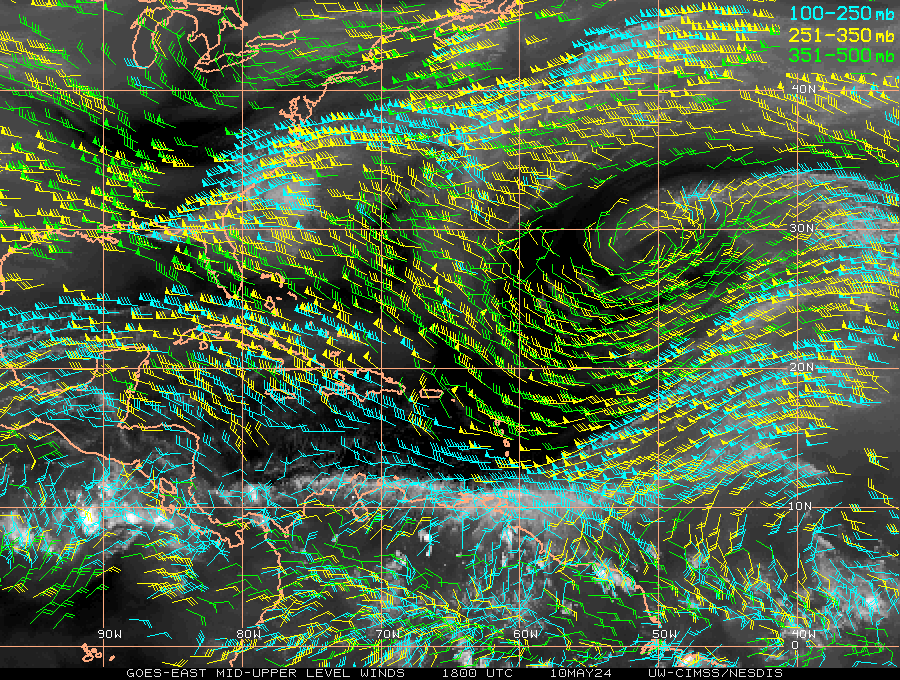
thetruesms wrote:I've been kind of neglecting 94L with the excitement around Alex :oops: Talk about a painfully apparent shear axis, though


do you think it has a future?
0 likes   

User avatar
msbee
S2K Supporter
S2K Supporter
Posts: 3010
Joined: Wed Jun 11, 2003 10:11 am
Location: St. Maarten

Re: ATL: INVEST 94L - DISCUSSION

#62 Postby msbee » Sat Jun 26, 2010 10:17 am

It sure was a non event here thankfully
unless I should worry abotu that burst east of Guadeloupe
Last edited by msbee on Sat Jun 26, 2010 10:19 am, edited 1 time in total.
0 likes   
Too many hurricanes to remember

User avatar
Hurricane Andrew
S2K Supporter
S2K Supporter
Posts: 1891
Age: 25
Joined: Sun May 23, 2010 2:53 pm
Location: KS

#63 Postby Hurricane Andrew » Sat Jun 26, 2010 10:17 am

Invest 94L is not on the map anymore.
0 likes   

The Enthusiast
NREMT-AEMT, WX nerd

Irene '11, Sandy '12, Irma '17 (SAR)

"Hard to think we were born to live this way..." -Wage War

User avatar
CourierPR
Category 5
Category 5
Posts: 1325
Age: 70
Joined: Tue Aug 31, 2004 7:53 pm
Location: Pompano Beach, Florida

Re: ATL: INVEST 94L - DISCUSSION

#64 Postby CourierPR » Sat Jun 26, 2010 10:23 am

Latest satellite loop shows that it might be getting better organized.
0 likes   

User avatar
Buck
Category 5
Category 5
Posts: 1128
Joined: Fri Sep 10, 2004 12:04 pm
Location: Atlanta, GA

#65 Postby Buck » Sat Jun 26, 2010 12:31 pm

Shear relaxing a bit... I think. Looks better in the last couple of hours than it did last night.
0 likes   

User avatar
KWT
Category 5
Category 5
Posts: 31391
Joined: Tue Aug 17, 2004 11:02 am
Location: UK!!!

#66 Postby KWT » Sat Jun 26, 2010 12:37 pm

I wouldn't rule this one out just yet, when it moves to the north I think conditions will become a little more condusive in time...
0 likes   
Personal Forecast Disclaimer:
The posts in this forum are NOT official forecast and should not be used as such. They are just the opinion of the poster and may or may not be backed by sound meteorological data. They are NOT endorsed by any professional institution or storm2k.org. For official information, please refer to the NHC and NWS products

User avatar
HURAKAN
Professional-Met
Professional-Met
Posts: 46086
Age: 37
Joined: Thu May 20, 2004 4:34 pm
Location: Key West, FL
Contact:

#67 Postby HURAKAN » Sat Jun 26, 2010 12:37 pm

Image

Heading under an ULL. In this cases, development, if any, is very slow.
0 likes   

User avatar
HURAKAN
Professional-Met
Professional-Met
Posts: 46086
Age: 37
Joined: Thu May 20, 2004 4:34 pm
Location: Key West, FL
Contact:

#68 Postby HURAKAN » Sat Jun 26, 2010 12:51 pm

Image

Upper and Lower interact
0 likes   

User avatar
cycloneye
Admin
Admin
Posts: 139778
Age: 67
Joined: Thu Oct 10, 2002 10:54 am
Location: San Juan, Puerto Rico

Re: ATL: INVEST 94L - DISCUSSION

#69 Postby cycloneye » Sat Jun 26, 2010 1:14 pm

TWOAT
TROPICAL WEATHER OUTLOOK
NWS TPC/NATIONAL HURRICANE CENTER MIAMI FL
200 PM EDT SAT JUN 26 2010

FOR THE NORTH ATLANTIC...CARIBBEAN SEA AND THE GULF OF MEXICO...

THE NATIONAL HURRICANE CENTER IS ISSUING ADVISORIES ON TROPICAL
STORM ALEX...LOCATED ABOUT 75 MILES EAST OF BELIZE CITY BELIZE.

CLOUDINESS AND SHOWERS EXTENDING FROM THE NORTHERN LEEWARD ISLANDS
NORTHEASTWARD INTO THE ATLANTIC FOR SEVERAL HUNDRED MILES ARE
ASSOCIATED WITH A TROPICAL WAVE INTERACTING WITH AN UPPER-LEVEL
TROUGH. THIS ACTIVITY HAS CHANGED LITTLE THIS AFTERNOON AND FURTHER
DEVELOPMENT...IF ANY...WILL BE SLOW TO OCCUR AS THE SYSTEM MOVES
TOWARD THE NORTH-NORTHWEST AT 10 TO 15 MPH. THERE IS A LOW
CHANCE...10
PERCENT...OF THIS SYSTEM BECOMING A TROPICAL CYCLONE DURING THE
NEXT 48 HOURS.


ELSEWHERE...TROPICAL CYCLONE FORMATION IS NOT EXPECTED DURING THE
NEXT 48 HOURS.

PUBLIC ADVISORIES ON TROPICAL STORM ALEX ONE ARE ISSUED UNDER
WMO HEADER WTNT31 KNHC AND UNDER AWIPS HEADER MIATCPAT1.
FORECAST/ADVISORIES ARE ISSUED UNDER WMO HEADER WTNT21 KNHC AND
UNDER AWIPS HEADER MIATCMAT1.

$$
FORECASTER ROBERTS/AVILA
0 likes   
Visit the Caribbean-Central America Weather Thread where you can find at first post web cams,radars
and observations from Caribbean basin members Click Here

User avatar
KWT
Category 5
Category 5
Posts: 31391
Joined: Tue Aug 17, 2004 11:02 am
Location: UK!!!

#70 Postby KWT » Sat Jun 26, 2010 1:16 pm

Its a really messy set-up out there thats for sure!
0 likes   
Personal Forecast Disclaimer:
The posts in this forum are NOT official forecast and should not be used as such. They are just the opinion of the poster and may or may not be backed by sound meteorological data. They are NOT endorsed by any professional institution or storm2k.org. For official information, please refer to the NHC and NWS products

User avatar
Gustywind
Category 5
Category 5
Posts: 12334
Joined: Mon Sep 03, 2007 7:29 am
Location: Baie-Mahault, GUADELOUPE

#71 Postby Gustywind » Sat Jun 26, 2010 2:03 pm

Thunder is rumbling strongly right now, and i have isolated lightnings, one have just bright my face behind my window... :eek:
0 likes   

User avatar
Gustywind
Category 5
Category 5
Posts: 12334
Joined: Mon Sep 03, 2007 7:29 am
Location: Baie-Mahault, GUADELOUPE

#72 Postby Gustywind » Sat Jun 26, 2010 2:09 pm

Image
0 likes   

User avatar
KWT
Category 5
Category 5
Posts: 31391
Joined: Tue Aug 17, 2004 11:02 am
Location: UK!!!

#73 Postby KWT » Sat Jun 26, 2010 2:11 pm

Looking a bit more linear thn it did yesterday, it had a very nice little curve to it then.
0 likes   
Personal Forecast Disclaimer:
The posts in this forum are NOT official forecast and should not be used as such. They are just the opinion of the poster and may or may not be backed by sound meteorological data. They are NOT endorsed by any professional institution or storm2k.org. For official information, please refer to the NHC and NWS products

User avatar
Gustywind
Category 5
Category 5
Posts: 12334
Joined: Mon Sep 03, 2007 7:29 am
Location: Baie-Mahault, GUADELOUPE

#74 Postby Gustywind » Sat Jun 26, 2010 2:15 pm

:uarrow:
Rain is back here, no winds.
0 likes   

User avatar
Gustywind
Category 5
Category 5
Posts: 12334
Joined: Mon Sep 03, 2007 7:29 am
Location: Baie-Mahault, GUADELOUPE

#75 Postby Gustywind » Sat Jun 26, 2010 2:21 pm

The burst east of Guadeloupe is refiring...
Image
0 likes   

User avatar
Gustywind
Category 5
Category 5
Posts: 12334
Joined: Mon Sep 03, 2007 7:29 am
Location: Baie-Mahault, GUADELOUPE

#76 Postby Gustywind » Sat Jun 26, 2010 2:28 pm

More showers are falling here, with the thunder noising frequently and very decently .
0 likes   

User avatar
Gustywind
Category 5
Category 5
Posts: 12334
Joined: Mon Sep 03, 2007 7:29 am
Location: Baie-Mahault, GUADELOUPE

#77 Postby Gustywind » Sat Jun 26, 2010 2:50 pm

Another strong lightning just over my face bright all my window, if this activity deteriotes i will have to shut down my computer! :eek:
0 likes   

User avatar
artist
Category 5
Category 5
Posts: 9792
Joined: Mon Jun 06, 2005 3:26 pm
Location: West Palm

Re:

#78 Postby artist » Sat Jun 26, 2010 4:03 pm

Gustywind wrote:Another strong lightning just over my face bright all my window, if this activity deteriotes i will have to shut down my computer! :eek:

stay safe Gusty and thanks for letting us know your conditions there.
0 likes   

Sihara
Tropical Storm
Tropical Storm
Posts: 137
Joined: Wed Jul 16, 2008 8:39 pm
Location: St. Petersburg, FL

Re:

#79 Postby Sihara » Sat Jun 26, 2010 4:12 pm

Gustywind wrote:Another strong lightning just over my face bright all my window, if this activity deteriotes i will have to shut down my computer! :eek:


don't be near the window with all that lightning. 94L is putting on quite a show for you!
0 likes   

User avatar
Gustywind
Category 5
Category 5
Posts: 12334
Joined: Mon Sep 03, 2007 7:29 am
Location: Baie-Mahault, GUADELOUPE

Re: Re:

#80 Postby Gustywind » Sat Jun 26, 2010 4:39 pm

Sihara wrote:
Gustywind wrote:Another strong lightning just over my face bright all my window, if this activity deteriotes i will have to shut down my computer! :eek:


don't be near the window with all that lightning. 94L is putting on quite a show for you!

Yeah thanks my friend, i appreciate your advices. Things have calm down, i was on the verge of closing and shut off my computer but hopefully things have became more calm so for the moment all is ok.
0 likes   


Return to “2010”

Who is online

Users browsing this forum: No registered users and 9 guests