00z Best Track
AL, 94, 2010092000, , BEST, 0, 156N, 316W, 25, 1008, DB
Looks like no upgrade at 11, but you never know if they will pull the trigger at the last minute.
ATL: LISA - Ex-Hurricane - Discussion
Moderator: S2k Moderators
-
cycloneye

- Admin

- Posts: 149579
- Age: 69
- Joined: Thu Oct 10, 2002 10:54 am
- Location: San Juan, Puerto Rico
Re: ATL: INVEST 94L - Discussion
0 likes
Visit the Caribbean-Central America Weather Thread where you can find at first post web cams,radars
and observations from Caribbean basin members Click Here
and observations from Caribbean basin members Click Here


Re: ATL: INVEST 94L - Discussion
I think that the NHC did a good job not upgrading this system in the afternoon, I guess they wanted to see if the convection was persistent and we can see it was not. I agree that the next D-max could help it as conditions look favorable.
0 likes
-
Florida1118
-
MGC

- S2K Supporter

- Posts: 5940
- Joined: Sun Mar 23, 2003 9:05 pm
- Location: Pass Christian MS, or what is left.
Re: ATL: INVEST 94L - Discussion
Convection is rather limited tonight...also, shear is kicking up....I'd say chances are a bit lower right now. But, things can change quickly in the tropics......MGC
0 likes
-
Brent
- S2K Supporter
- Posts: 38765
- Age: 37
- Joined: Sun May 16, 2004 10:30 pm
- Location: Tulsa Oklahoma
- Contact:
Re: ATL: INVEST 94L - Discussion
TROPICAL WEATHER OUTLOOK
NWS TPC/NATIONAL HURRICANE CENTER MIAMI FL
200 AM EDT MON SEP 20 2010
FOR THE NORTH ATLANTIC...CARIBBEAN SEA AND THE GULF OF MEXICO...
THE NATIONAL HURRICANE CENTER IS ISSUING ADVISORIES ON HURRICANE
IGOR...LOCATED ABOUT 80 MILES NORTH-NORTHWEST OF BERMUDA...AND ON
TROPICAL STORM JULIA...LOCATED ABOUT 1215 MILES WEST OF THE AZORES.
AN AREA OF LOW PRESSURE LOCATED ABOUT 400 MILES WEST OF THE CAPE
VERDE ISLANDS CONTINUES TO SHOW SIGNS OF ORGANIZATION...AND
CONDITIONS ARE FAVORABLE FOR A TROPICAL DEPRESSION TO FORM DURING
THE NEXT DAY OR SO AS THIS SYSTEM MOVES SLOWLY NORTHWESTWARD. THERE
IS A HIGH CHANCE...80 PERCENT...OF THIS SYSTEM BECOMING A TROPICAL
CYCLONE DURING THE NEXT 48 HOURS.
ELSEWHERE...TROPICAL CYCLONE FORMATION IS NOT EXPECTED DURING THE
NEXT 48 HOURS.
$$
FORECASTER BRENNAN
0 likes
#neversummer

Re: ATL: INVEST 94L - Discussion
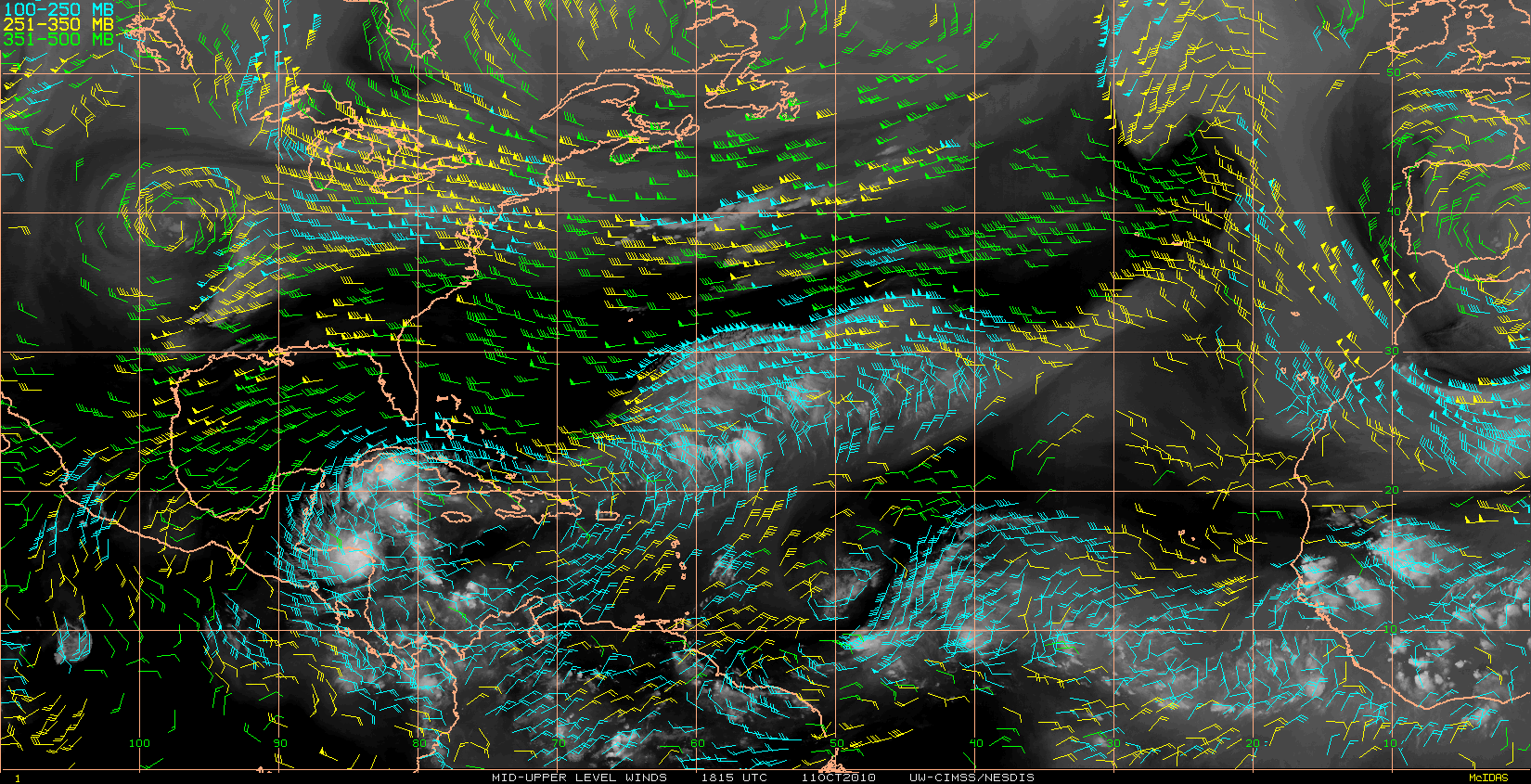
Looks like UL winds are about 10 knots over the LLC blowing from the SW.
As a result strong convection is slightly displaced from being directly over the LLC.
From Dvorak, it is slightly to the SE, but should be close enough to effectively heat the core and help to vertically align the vortex.


As a result strong convection is slightly displaced from being directly over the LLC.
From Dvorak, it is slightly to the SE, but should be close enough to effectively heat the core and help to vertically align the vortex.
0 likes

-
cycloneye
- Admin
- Posts: 149579
- Age: 69
- Joined: Thu Oct 10, 2002 10:54 am
- Location: San Juan, Puerto Rico
Re: ATL: INVEST 94L - Discussion
This has to be a TC sometime today, unless it falls apart rapidly.
0 likes
Visit the Caribbean-Central America Weather Thread where you can find at first post web cams,radars
and observations from Caribbean basin members Click Here
and observations from Caribbean basin members Click Here
Re: ATL: INVEST 94L - Discussion
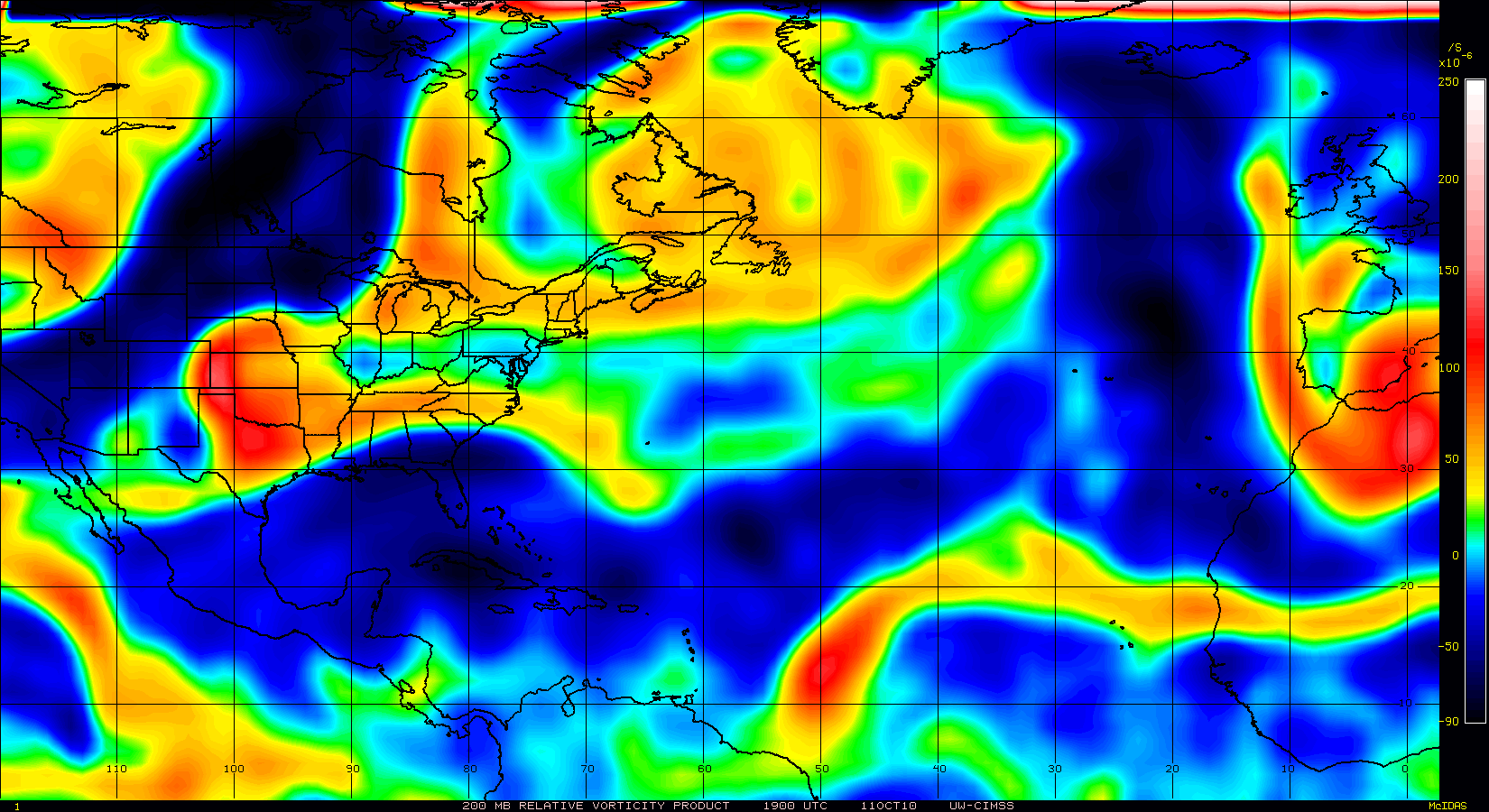
A broad upper-level trough to its north seems to be supporting a moderate poleward outflow channel.
0 likes
Re: ATL: INVEST 94L - Discussion
Good concentration of overshooting tops around it with a strong cell nearly over the LLC.
The roll on MIMIC-TPW shows a good convergence of moist air into the LLC with no dry-air entrainment.
Core should heat up nicely today.
http://cimss.ssec.wisc.edu/tropic/real- ... t72hrs.gif
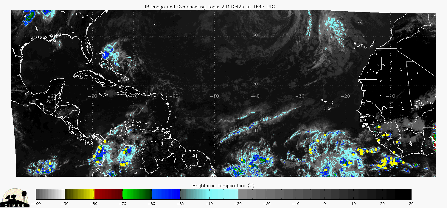

The roll on MIMIC-TPW shows a good convergence of moist air into the LLC with no dry-air entrainment.
Core should heat up nicely today.
http://cimss.ssec.wisc.edu/tropic/real- ... t72hrs.gif
0 likes
Re: ATL: INVEST 94L - Discussion
I just ran a HYSPLIT trajectory analysis for a parcel just in the ITCZ at 10N 40W ahead of the LLC.
It is showing a trajectory toward the LLC with very good ascent.

It is showing a trajectory toward the LLC with very good ascent.
0 likes
-
HURAKAN

- Professional-Met

- Posts: 46084
- Age: 39
- Joined: Thu May 20, 2004 4:34 pm
- Location: Key West, FL
- Contact:
Re: ATL: INVEST 94L - Discussion

WTNT21 KNGU 200700
SUBJ/TROPICAL CYCLONE FORMATION ALERT//
RMKS/1. FORMATION OF A SIGNIFICANT TROPICAL CYCLONE IS POSSIBLE WITHIN
100 NM EITHER SIDE OF A LINE FROM 16.2N 31.8W TO 19.1N 34.8W
WITHIN THE NEXT 12 TO 24 HOURS. AVAILABLE DATA DOES NOT JUSTIFY
ISSUANCE OF NUMBERED TROPICAL CYCLONE WARNINGS AT THIS TIME.
2. REMARKS: CURRENT GLOBAL AND REGIONAL GUIDANCE ARE DEPICTING
GRADUAL INTENSIFICATION OF A 1008 MB LOW SITUATED APPROXIMATELY 480NM
WEST-NORTHWEST OF PRAIA, CAPE VERDE OVER THE NEXT 24 HOURS. THIS
SYSTEM IS MOVING NORTHWEST AT APPROXIMATELY 10 KTS. CURRENTLY
SATELLITE IMAGERY DEPICTS MORE ORGANIZATION OF THIS SYSTEM OVER THE
PAST 12 HOURS. THIS IN CONJUNCTION WITH WARM SEA SURFACE TEMPERATURES
OF 80 TO 82 DEGREES FAHRENHEIT, DECREASING VERTICAL WIND SHEAR, AND
AN UPPER LEVEL ANTICYCLONE SHOULD HELP TO ENHANCE THE DEVELOPMENT OF
THIS TROPICAL FEATURE.
3. THIS ALERT WILL BE REISSUED, UPGRADED TO WARNING OR CANCELLED
BY 210700Z.//
0 likes
Re: ATL: INVEST 94L - Discussion
Both EURO and GFS are supporting a strong Bermuda High in the wake of Igor due to solar heating of Igor's outflow clouds.
http://moe.met.fsu.edu/cgi-bin/ecmwf-en ... =Animation
http://moe.met.fsu.edu/cgi-bin/gfstc2.c ... =Animation
GFS seems to be more aggressive however in having the High build to the the east and push 94L west bound.
NCEP ensembles have pretty much stalled 94L out for the time being.

http://moe.met.fsu.edu/cgi-bin/ecmwf-en ... =Animation
http://moe.met.fsu.edu/cgi-bin/gfstc2.c ... =Animation
GFS seems to be more aggressive however in having the High build to the the east and push 94L west bound.
NCEP ensembles have pretty much stalled 94L out for the time being.
0 likes
Re: ATL: INVEST 94L - Discussion
Nice high rain-rate cell firing.
Looks like firing high enough to develop a cirrus canopy.
This should nail spin up.


Looks like firing high enough to develop a cirrus canopy.
This should nail spin up.
0 likes

Without a doubt this becomes TD14 today, looking very good and I'd imagine next advisory cycle will see this one get upgraded.
0 likes
Personal Forecast Disclaimer:
The posts in this forum are NOT official forecast and should not be used as such. They are just the opinion of the poster and may or may not be backed by sound meteorological data. They are NOT endorsed by any professional institution or storm2k.org. For official information, please refer to the NHC and NWS products
The posts in this forum are NOT official forecast and should not be used as such. They are just the opinion of the poster and may or may not be backed by sound meteorological data. They are NOT endorsed by any professional institution or storm2k.org. For official information, please refer to the NHC and NWS products
-
HURAKAN
- Professional-Met
- Posts: 46084
- Age: 39
- Joined: Thu May 20, 2004 4:34 pm
- Location: Key West, FL
- Contact:
291
ABNT20 KNHC 201154
TWOAT
TROPICAL WEATHER OUTLOOK
NWS TPC/NATIONAL HURRICANE CENTER MIAMI FL
800 AM EDT MON SEP 20 2010
FOR THE NORTH ATLANTIC...CARIBBEAN SEA AND THE GULF OF MEXICO...
THE NATIONAL HURRICANE CENTER IS ISSUING ADVISORIES ON HURRICANE
IGOR...LOCATED ABOUT 200 MILES NORTH OF BERMUDA...AND ON
TROPICAL STORM JULIA...LOCATED ABOUT 1165 MILES WEST OF THE AZORES.
AN AREA OF LOW PRESSURE LOCATED ABOUT 400 MILES WEST OF THE CAPE
VERDE ISLANDS CONTINUES TO SHOW SIGNS OF ORGANIZATION...AND
CONDITIONS ARE CURRENTLY FAVORABLE FOR SOME ADDITIONAL DEVELOPMENT
AS THE SYSTEM MOVES SLOWLY NORTHWESTWARD. THERE IS A HIGH
CHANCE...80 PERCENT...OF THIS SYSTEM BECOMING A TROPICAL
CYCLONE DURING THE NEXT 48 HOURS.
ELSEWHERE...TROPICAL CYCLONE FORMATION IS NOT EXPECTED DURING THE
NEXT 48 HOURS.
$$
FORECASTER FRANKLIN
0 likes
Who is online
Users browsing this forum: No registered users and 46 guests