
I really wouldn't worry too much now, the models really are a very long way east of a US threat (a few thousand I suspect) and that would take a massive shift away from where we are now, esp given the solid model support.
Now as I've been saying Bermuda probably isn't out of the action just yet...
ATL: Ex-Hurricane DANIELLE - Discussion
Moderator: S2k Moderators
0 likes
Personal Forecast Disclaimer:
The posts in this forum are NOT official forecast and should not be used as such. They are just the opinion of the poster and may or may not be backed by sound meteorological data. They are NOT endorsed by any professional institution or storm2k.org. For official information, please refer to the NHC and NWS products
The posts in this forum are NOT official forecast and should not be used as such. They are just the opinion of the poster and may or may not be backed by sound meteorological data. They are NOT endorsed by any professional institution or storm2k.org. For official information, please refer to the NHC and NWS products
-
cycloneye

- Admin

- Posts: 149604
- Age: 69
- Joined: Thu Oct 10, 2002 10:54 am
- Location: San Juan, Puerto Rico
Re: ATL : Tropical Storm DANIELLE - Discussion
The question is not if is going to be any threat to the East Coast of the U.S. or Bermuda,the question is how strong Danielle will be at its peak and how many ACE units it gets. Will it be the strongest cyclone in the 2010 Atlantic season (surpassing Alex strengh)? Or we will see a few more very strong ones down the road?
0 likes
Visit the Caribbean-Central America Weather Thread where you can find at first post web cams,radars
and observations from Caribbean basin members Click Here
and observations from Caribbean basin members Click Here
-
WeatherGuesser
- Category 5

- Posts: 2672
- Joined: Tue Jun 29, 2010 6:46 am
I'm not concerned at all about the US mainland. In a few days if it hasn't turned it might start to be of concern to the Maritimes.
Is it my imagination, or have they backed off on the strength? I thought they were putting it at H2 earlier.
the question is how strong Danielle will be at its peak.
Is it my imagination, or have they backed off on the strength? I thought they were putting it at H2 earlier.
Last edited by WeatherGuesser on Mon Aug 23, 2010 6:14 am, edited 1 time in total.
0 likes
Re: ATL : Tropical Storm DANIELLE - Discussion
cycloneye wrote:The question is not if is going to be any threat to the East Coast of the U.S. or Bermuda,the question is how strong Danielle will be at its peak. Will it be the strongest cyclone in the 2010 Atlantic season (surpassing Alex strengh)? Or we will see a few more very strong ones down the road?
I'm not sure we should dismiss Bermuda threat at all, would only need a fairly minor westward adjustment and the cone would be put over Bermuda...
For sure this one will be a strong one though, I just see no reason why this one won't be a 3/4 in a few days time but I'll bet we get something stronger then this one this season, esp in the Caribbean later in the season...
0 likes
Personal Forecast Disclaimer:
The posts in this forum are NOT official forecast and should not be used as such. They are just the opinion of the poster and may or may not be backed by sound meteorological data. They are NOT endorsed by any professional institution or storm2k.org. For official information, please refer to the NHC and NWS products
The posts in this forum are NOT official forecast and should not be used as such. They are just the opinion of the poster and may or may not be backed by sound meteorological data. They are NOT endorsed by any professional institution or storm2k.org. For official information, please refer to the NHC and NWS products
-
OuterBanker
- S2K Supporter

- Posts: 1761
- Joined: Wed Feb 26, 2003 10:53 am
- Location: Nags Head, NC
- Contact:
-
I Scream Cone
- Tropical Low

- Posts: 12
- Joined: Mon Aug 23, 2010 5:46 am
Re:
OuterBanker wrote:Fun to watch. Fish not affecting anyone. Good news. Big difference from yesterday in euro. What a relief.
Hmmm as everyone know I was on the recurve boat form the get-go but FWIW I still think Bermuda must watch this system, 5 degrees east at 120hrs is still close to the error that the models show that far out on average so could yet see things change on the models to bring more of a threat to Bermuda, esp if this one does become a strong and big hurricane.
0 likes
Personal Forecast Disclaimer:
The posts in this forum are NOT official forecast and should not be used as such. They are just the opinion of the poster and may or may not be backed by sound meteorological data. They are NOT endorsed by any professional institution or storm2k.org. For official information, please refer to the NHC and NWS products
The posts in this forum are NOT official forecast and should not be used as such. They are just the opinion of the poster and may or may not be backed by sound meteorological data. They are NOT endorsed by any professional institution or storm2k.org. For official information, please refer to the NHC and NWS products
-
cycloneye
- Admin
- Posts: 149604
- Age: 69
- Joined: Thu Oct 10, 2002 10:54 am
- Location: San Juan, Puerto Rico
Re: ATL : Tropical Storm DANIELLE - Discussion
I Scream Cone wrote:Not so sure about being a fish.....
What do you see that may occur to cause Danielle to not be a fish?
0 likes
Visit the Caribbean-Central America Weather Thread where you can find at first post web cams,radars
and observations from Caribbean basin members Click Here
and observations from Caribbean basin members Click Here
-
I Scream Cone
- Tropical Low
- Posts: 12
- Joined: Mon Aug 23, 2010 5:46 am
Re: ATL : Tropical Storm DANIELLE - Discussion
Because it could still possibly affect Bermuda, no? If it misses the first trough (being that it is already south of the forecast points), it could take the turn a little later.
0 likes
-
I Scream Cone
- Tropical Low
- Posts: 12
- Joined: Mon Aug 23, 2010 5:46 am
-
cycloneye
- Admin
- Posts: 149604
- Age: 69
- Joined: Thu Oct 10, 2002 10:54 am
- Location: San Juan, Puerto Rico
Re: ATL : Tropical Storm DANIELLE - Discussion
One word to describe it=Impressive

0 likes
Visit the Caribbean-Central America Weather Thread where you can find at first post web cams,radars
and observations from Caribbean basin members Click Here
and observations from Caribbean basin members Click Here
Center looks just a little bit to the east of that ICS but for now its moving probably only about 280-285, not picking up much latitude at the moment, and obviously the further west it goes the risk to Bermuda does increase.
0 likes
Personal Forecast Disclaimer:
The posts in this forum are NOT official forecast and should not be used as such. They are just the opinion of the poster and may or may not be backed by sound meteorological data. They are NOT endorsed by any professional institution or storm2k.org. For official information, please refer to the NHC and NWS products
The posts in this forum are NOT official forecast and should not be used as such. They are just the opinion of the poster and may or may not be backed by sound meteorological data. They are NOT endorsed by any professional institution or storm2k.org. For official information, please refer to the NHC and NWS products
-
Cryomaniac
- Category 5
- Posts: 1289
- Joined: Tue Aug 15, 2006 2:26 pm
- Location: Newark, Nottinghamshire, UK
- Contact:
-
WeatherGuesser
- Category 5
- Posts: 2672
- Joined: Tue Jun 29, 2010 6:46 am
-
I Scream Cone
- Tropical Low
- Posts: 12
- Joined: Mon Aug 23, 2010 5:46 am
Thank you, KWT. I was also pondering the prospect of a possible threat to the CONUS if the initialization of the center is wrong. Is the second trough going to reach Danielle in time, or is the ridge going to be strong enough for her to maintain a more WNW motion enabling a threat. I mean, the models were trending more to the west yesterday....
Last edited by I Scream Cone on Mon Aug 23, 2010 6:45 am, edited 1 time in total.
0 likes

Re: ATL : Tropical Storm DANIELLE - Discussion
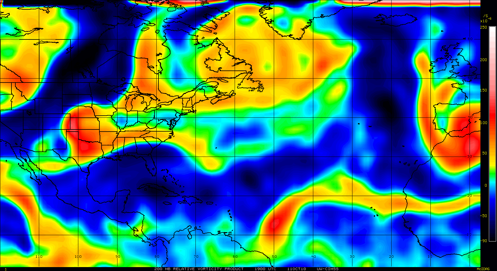
IMHO Danielle's track will be influenced in the next couple days by the TUTT currently located at 26N 45W. Its position is shown on 200mb vorticity.
I think as Danielle draws closer to the TUTT, the TUTT will help to create an enhance poleward outflow channel.
That will help to strengthen Danielle and increase vorticity in the upper levels.
That in turn will create a Fujiwhara interaction with the TUTT and Danielle and cause Danielle to make a more hard right turn as it gets closer to the TUTT.
300mb GFS forecast seems to be pointing in that direction.
The interaction seems to kick in about 60 hrs out.
0 likes
Re:
I Scream Cone wrote:Thank you, KWT. I was also pondering the prospect of a possible threat to the CONUS if the initialization of the center is wrong. Is the second trough going to reach Danielle in time, or is the ridge going to be strong enough for her to maintain a more WNW motion enabling a threat. I mean, the models were trending more to the west yesterday....
I'd be rather surprised if this got much further west then to threaten Bermuda but you never know, I've been thinking 60-70W for a while and I think thats still the case and the models may have gone just a smidge too far east now.
As has been said though this one does look like its well on its way to being a hurricane, I'd say 60kts right now personally...
0 likes
Personal Forecast Disclaimer:
The posts in this forum are NOT official forecast and should not be used as such. They are just the opinion of the poster and may or may not be backed by sound meteorological data. They are NOT endorsed by any professional institution or storm2k.org. For official information, please refer to the NHC and NWS products
The posts in this forum are NOT official forecast and should not be used as such. They are just the opinion of the poster and may or may not be backed by sound meteorological data. They are NOT endorsed by any professional institution or storm2k.org. For official information, please refer to the NHC and NWS products
-
I Scream Cone
- Tropical Low
- Posts: 12
- Joined: Mon Aug 23, 2010 5:46 am
-
Air Force Met
- Military Met

- Posts: 4372
- Age: 57
- Joined: Tue Jul 08, 2003 9:30 am
- Location: Roan Mountain, TN
Re: ATL : Tropical Storm DANIELLE - Discussion
jconsor wrote:I would put money on the 9z NHC position being about 50 miles too far north or northeast. We'll see very shortly when the first few visible images become available. Even if the LLC is still on the eastern edge of the convection, given the improving organization and anticyclone developing over the system, the LLC will most likely relocate very soon closer to the MLC which is now at about 14.2N 38W.
Yeah...its off. When they readjust the center at 11am...it will look as if it went wsw...but its a correction. Their placement is too far north and way too far east.
0 likes

Re: ATL : Tropical Storm DANIELLE - Discussion
IMHO Danielle's track will be influenced in the next couple days by the TUTT currently located at 26N 45W. Its position is shown on 200mb vorticity.
I've been watching that ULL drop southwest in the WV imagery. It has been weakening overnight but will at least be a player in providing an outflow channel. Its pretty common for a ULL in that location to drop down in front of a developing hurricane then travel west with it, but this particular ULL would have to hurry south or it will miss. I think Danielle is beginning to respond to the ridge and will be picking up speed WNW lter today.
0 likes
Who is online
Users browsing this forum: No registered users and 54 guests