ATL: IGOR - Ex Hurricane - Discussion
Moderator: S2k Moderators


Can someone post an explanation of the current steering pattern for Igor for someone who knows nothing about that sort of thing? Just curious how it's interpreted. Thanks.
0 likes
The preceding post is NOT an official forecast and should not be used as such. It is just the opinion of the poster and may or may not be backed by sound meteorological data. It is NOT endorsed by any professional institution or storm2k.org. For official information, please refer to the NHC and NWS products.
-
hurricaneCW
- Category 5

- Posts: 1799
- Joined: Wed Mar 03, 2010 6:20 am
- Location: Toms River, NJ
Re: ATL: Hurricane IGOR - Discussion
I just don't see how this could get further west than 60-65W, there is such a huge weakness in the Western Atlantic and Igor is hanging by a string to the subtropical high.
0 likes
-
stormhunter7

- Category 2

- Posts: 763
- Joined: Mon May 26, 2008 3:13 pm
- Location: Panama City Beach, Florida
- Contact:
Re: ATL: Hurricane IGOR - Discussion
Good morning Igor!  Sleep well i see... lol
0 likes
The following post is NOT an official forecast and should not be used as such. It is just the opinion of the poster and may or may not be backed by sound meteorological data. It is NOT endorsed by any professional institution including storm2k.org For Official Information please refer to the NHC and NWS products. http://www.nhc.noaa.gov
-
tolakram
- Admin

- Posts: 20186
- Age: 62
- Joined: Sun Aug 27, 2006 8:23 pm
- Location: Florence, KY (name is Mark)
Re: ATL: Hurricane IGOR - Discussion
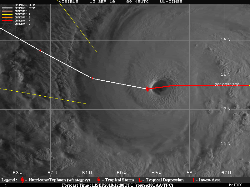
I saved my favorite pic from this morning.

0 likes
M a r k
- - - - -
Join us in chat: Storm2K Chatroom Invite. Android and IOS apps also available.
The posts in this forum are NOT official forecasts and should not be used as such. Posts are NOT endorsed by any professional institution or STORM2K.org. For official information and forecasts, please refer to NHC and NWS products.
-
tolakram
- Admin
- Posts: 20186
- Age: 62
- Joined: Sun Aug 27, 2006 8:23 pm
- Location: Florence, KY (name is Mark)
Re: ATL: Hurricane IGOR - Discussion
Latest image not too bad either.

0 likes
M a r k
- - - - -
Join us in chat: Storm2K Chatroom Invite. Android and IOS apps also available.
The posts in this forum are NOT official forecasts and should not be used as such. Posts are NOT endorsed by any professional institution or STORM2K.org. For official information and forecasts, please refer to NHC and NWS products.
- - - - -
Join us in chat: Storm2K Chatroom Invite. Android and IOS apps also available.
The posts in this forum are NOT official forecasts and should not be used as such. Posts are NOT endorsed by any professional institution or STORM2K.org. For official information and forecasts, please refer to NHC and NWS products.
-
chris_fit

- Category 5
- Posts: 3261
- Age: 43
- Joined: Wed Sep 10, 2003 11:58 pm
- Location: Tampa Bay Area, FL
Re: ATL: Hurricane IGOR - Discussion
stormhunter7 wrote:Good morning Igor!
Nice! Where can I go to get a map like that showing the track overlay with the latest satellite?
0 likes
-
tolakram
- Admin
- Posts: 20186
- Age: 62
- Joined: Sun Aug 27, 2006 8:23 pm
- Location: Florence, KY (name is Mark)
Re: ATL: Hurricane IGOR - Discussion
chris_fit wrote:Nice! Where can I go to get a map like that showing the track overlay with the latest satellite?
http://cimss.ssec.wisc.edu/tropic2/#
0 likes
M a r k
- - - - -
Join us in chat: Storm2K Chatroom Invite. Android and IOS apps also available.
The posts in this forum are NOT official forecasts and should not be used as such. Posts are NOT endorsed by any professional institution or STORM2K.org. For official information and forecasts, please refer to NHC and NWS products.
- - - - -
Join us in chat: Storm2K Chatroom Invite. Android and IOS apps also available.
The posts in this forum are NOT official forecasts and should not be used as such. Posts are NOT endorsed by any professional institution or STORM2K.org. For official information and forecasts, please refer to NHC and NWS products.
-
Aric Dunn
- Category 5
- Posts: 21238
- Age: 43
- Joined: Sun Sep 19, 2004 9:58 pm
- Location: Ready for the Chase.
- Contact:
Not exactly doing what its supposed to... lol
0 likes
Note: If I make a post that is brief. Please refer back to previous posts for the analysis or reasoning. I do not re-write/qoute what my initial post said each time.
If there is nothing before... then just ask
Space & Atmospheric Physicist, Embry-Riddle Aeronautical University,
I believe the sky is falling...
If there is nothing before... then just ask
Space & Atmospheric Physicist, Embry-Riddle Aeronautical University,
I believe the sky is falling...
Re: ATL: Hurricane IGOR - Discussion
someone mentioned a ULL to igor's east.....and the small ifluence on track that it may have....but i can't find evidence of any ULL....(based on 200 mb vorticity maps).....
ARIC do you think the GFS is out to lunch with it's timing in breaking down the ridge and/or how much In your opinion Igor be "creating his own enviornment" to a degree ....as far as pumping up (ridge)heights to his N and NW .
ARIC do you think the GFS is out to lunch with it's timing in breaking down the ridge and/or how much In your opinion Igor be "creating his own enviornment" to a degree ....as far as pumping up (ridge)heights to his N and NW .
0 likes
-
Aric Dunn
- Category 5
- Posts: 21238
- Age: 43
- Joined: Sun Sep 19, 2004 9:58 pm
- Location: Ready for the Chase.
- Contact:
Re: ATL: Hurricane IGOR - Discussion
cpdaman wrote:someone mentioned a ULL to igor's east.....and the small ifluence on track that it may have....but i can't find evidence of any ULL....(based on 200 mb vorticity maps).....
ARIC do you think the GFS is out to lunch with it's timing in breaking down the ridge and/or how much In your opinion Igor be "creating his own enviornment" to a degree ....as far as pumping up (ridge)heights to his N and NW .
yes of course it is... there is no way it can make the 12 hour position that the GFS has.. I still think its going to recurve just not such a near right angle turn as the models are saying..
as for the steering there is still ridging NW of igor in the upper steering levels. which is likely the cause of its present motion. if the ridge holds a little longer than things may change some
0 likes
Note: If I make a post that is brief. Please refer back to previous posts for the analysis or reasoning. I do not re-write/qoute what my initial post said each time.
If there is nothing before... then just ask
Space & Atmospheric Physicist, Embry-Riddle Aeronautical University,
I believe the sky is falling...
If there is nothing before... then just ask
Space & Atmospheric Physicist, Embry-Riddle Aeronautical University,
I believe the sky is falling...
-
Shuriken
Re: ATL: Hurricane IGOR - Discussion
x-y-no wrote:If the GFS is even close to right in building the mid-level ridge over Florida/Cuba/Haiti then that doesn't seem possible. It would have to go SW, which seems unlikely in the extreme.painkillerr wrote:If it slows down (as it seems), it can miss the trough and continue west.

0 likes
-
ColinDelia

- S2K Supporter

- Posts: 918
- Joined: Mon Aug 29, 2005 5:52 am
- Location: The Beach, FL
Re: ATL: Hurricane IGOR - Discussion
cpdaman wrote:someone mentioned a ULL to igor's east.....and the small ifluence on track that it may have....but i can't find evidence of any ULL....(based on 200 mb vorticity maps).....
They were looking at the ULL WAY to the Northeast. Here is a 200 mb streamline map.
http://cimss.ssec.wisc.edu/tropic2/pred ... l200-0.GIF
0 likes


Re: ATL: Hurricane IGOR - Discussion
Shuriken wrote:x-y-no wrote:If the GFS is even close to right in building the mid-level ridge over Florida/Cuba/Haiti then that doesn't seem possible. It would have to go SW, which seems unlikely in the extreme.painkillerr wrote:If it slows down (as it seems), it can miss the trough and continue west.
The synoptic setups were entirely different. For Ike, there was no trough coming from the east to break down the ridge, like we have now.
0 likes
-
Aric Dunn
- Category 5
- Posts: 21238
- Age: 43
- Joined: Sun Sep 19, 2004 9:58 pm
- Location: Ready for the Chase.
- Contact:
does not seem to be slowing down all too much .. and its still heading just south of Due west and to meet the next forecast point it would have to be moving WNW.
0 likes
Note: If I make a post that is brief. Please refer back to previous posts for the analysis or reasoning. I do not re-write/qoute what my initial post said each time.
If there is nothing before... then just ask
Space & Atmospheric Physicist, Embry-Riddle Aeronautical University,
I believe the sky is falling...
If there is nothing before... then just ask
Space & Atmospheric Physicist, Embry-Riddle Aeronautical University,
I believe the sky is falling...


Definitely moving faster than forecast...close to 45% of the way to the next forecast point, even though only about 26% of the forecast time has elapsed...maybe it's not quite ready to turn.
http://www.ssd.noaa.gov/goes/flt/t1/flash-vis.html
http://www.ssd.noaa.gov/goes/flt/t1/flash-vis.html
0 likes
Who is online
Users browsing this forum: No registered users and 69 guests