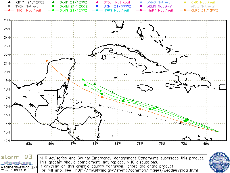
ATL : TROPICAL DEPRESSION ALEX - MODELS

Moderator: S2k Moderators

Message
Author
User avatar
HURAKAN
Professional-Met
Professional-Met
Posts: 46086
Age: 37
Joined: Thu May 20, 2004 4:34 pm
Location: Key West, FL
Contact:

ATL : TROPICAL DEPRESSION ALEX - MODELS

#1 Postby HURAKAN » Mon Jun 21, 2010 8:18 am

Code: Select all

                    *   ATLANTIC SHIPS INTENSITY FORECAST       *
                    *      GOES DATA AVAILABLE                  *
                    *      OHC  DATA AVAILABLE                  *
                    *  INVEST      AL932010  06/21/10  12 UTC   *

TIME (HR)          0     6    12    18    24    36    48    60    72    84    96   108   120
V (KT) NO LAND    25    27    29    33    37    46    56    65    70    76    80    84    88
V (KT) LAND       25    27    29    33    37    46    56    65    70    76    80    84    88
V (KT) LGE mod    25    26    27    29    31    35    41    49    59    70    80    90    96

SHEAR (KT)         7     7    12     9     5     7     7     5     8     4     2     6     8
SHEAR ADJ (KT)    -4    -2    -4    -6    -3    -4    -2    -2    -4    -4    -3    -5    -4
SHEAR DIR        212   168   172   185   266   183   285   263   301   213   291   229   348
SST (C)         28.9  28.9  28.9  28.8  28.8  28.8  28.9  29.0  29.1  29.2  29.3  29.5  29.6
POT. INT. (KT)   151   151   151   149   149   149   150   151   152   154   155   159   160
ADJ. POT. INT.   151   150   151   149   148   147   146   145   143   144   145   147   146
200 MB T (C)   -53.2 -52.3 -52.1 -52.5 -52.9 -52.1 -52.7 -52.4 -53.0 -52.6 -52.9 -52.6 -53.0
TH_E DEV (C)       7     7     6     6     6     8     8    10    10    12    10    12    10
700-500 MB RH     83    84    85    82    81    80    78    74    72    68    67    64    64
GFS VTEX (KT)      0  LOST  LOST  LOST  LOST  LOST  LOST  LOST  LOST  LOST  LOST  LOST  LOST
850 MB ENV VOR    67    84    82    85    80    80    67    71    65    69    57    52    26
200 MB DIV        83    78    83    84    80    79    58    44    23     7   -11    -3     3
LAND (KM)        238   207   178   195   201   326   231   192   276   265   212   241   228
LAT (DEG N)     13.0  13.3  13.6  14.0  14.3  15.1  15.7  16.3  16.6  16.9  17.4  18.0  18.5
LONG(DEG W)     67.2  68.3  69.4  70.7  71.9  74.3  76.6  78.6  80.3  81.7  83.1  84.3  85.4
STM SPEED (KT)    12    11    12    13    12    12    11     9     7     7     7     6     5
HEAT CONTENT      67    56    64    76    76    70    82   113   104    83    91    87    84

  FORECAST TRACK FROM BAMM      INITIAL HEADING/SPEED (DEG/KT):280/ 13      CX,CY: -12/  2
  T-12 MAX WIND:  25            PRESSURE OF STEERING LEVEL (MB):  640  (MEAN=624)
  GOES IR BRIGHTNESS TEMP. STD DEV.  50-200 KM RAD:  23.1 (MEAN=14.5)
  % GOES IR PIXELS WITH T < -20 C    50-200 KM RAD:  75.0 (MEAN=65.0)

                        INDIVIDUAL CONTRIBUTIONS TO INTENSITY CHANGE
                         6   12   18   24   36   48   60   72   84   96  108  120
                        ----------------------------------------------------------
  SAMPLE MEAN CHANGE     1.   2.   3.   4.   6.   8.   9.  11.  11.  12.  13.  13.
  SST POTENTIAL          0.   0.   0.   1.   6.  13.  21.  26.  31.  34.  36.  38.
  VERTICAL SHEAR MAG     1.   2.   4.   5.   7.   9.  11.  11.  12.  14.  15.  15.
  VERTICAL SHEAR ADJ     0.   1.   1.   1.   2.   3.   4.   4.   4.   4.   3.   3.
  VERTICAL SHEAR DIR     0.  -1.  -1.  -2.  -3.  -4.  -5.  -6.  -7.  -8. -10. -10.
  PERSISTENCE            0.  -1.  -1.  -1.  -1.  -1.  -1.  -1.  -1.   0.   0.   0.
  200/250 MB TEMP.       0.   0.  -1.  -1.  -1.  -2.  -2.  -2.  -3.  -3.  -3.  -3.
  THETA_E EXCESS         0.  -1.  -1.  -2.  -2.  -3.  -3.  -4.  -5.  -5.  -5.  -5.
  700-500 MB RH          0.   0.   0.  -1.  -1.  -2.  -2.  -2.  -2.  -2.  -2.  -2.
  GFS VORTEX TENDENCY    0.   0.   0.   0.  -1.  -1.  -1.  -1.  -1.  -2.  -2.  -2.
  850 MB ENV VORTICITY   0.   1.   1.   1.   2.   3.   4.   4.   5.   5.   5.   5.
  200 MB DIVERGENCE      0.   1.   2.   2.   4.   5.   6.   6.   5.   4.   4.   3.
  ZONAL STORM MOTION     0.   0.   1.   1.   1.   2.   2.   2.   3.   3.   4.   4.
  STEERING LEVEL PRES    0.   0.   0.   0.   0.   0.   0.   0.  -1.   0.   0.   0.
  DAYS FROM CLIM. PEAK   0.   0.   0.   0.   0.  -1.  -1.  -1.  -1.  -1.   0.  -1.
  GOES PREDICTORS        1.   1.   1.   1.   1.   1.   1.   0.   0.   0.   0.   0.
  OCEAN HEAT CONTENT     0.   0.   0.   0.   0.   0.   0.  -1.  -1.   0.   2.   5.
                        ----------------------------------------------------------
  TOTAL CHANGE           2.   4.   8.  12.  21.  31.  40.  45.  51.  55.  59.  63.

   ** 2010 ATLANTIC RI INDEX AL932010 INVEST     06/21/10  12 UTC **
           ( 30 KT OR MORE MAX WIND INCREASE IN NEXT 24 HR)
 
 12 HR PERSISTENCE (KT):   0.0 Range:-45.0 to  30.0 Scaled/Wgted Val:  0.6/  1.3
 850-200 MB SHEAR (KT) :   8.0 Range: 26.2 to   3.2 Scaled/Wgted Val:  0.8/  1.0
 D200 (10**7s-1)       :  81.6 Range:-21.0 to 140.0 Scaled/Wgted Val:  0.6/  0.9
 POT = MPI-VMAX (KT)   : 124.9 Range: 33.5 to 126.5 Scaled/Wgted Val:  1.0/  0.7
 850-700 MB REL HUM (%):  85.2 Range: 56.0 to  85.0 Scaled/Wgted Val:  1.0/  0.6
 % area w/pixels <-30 C:  71.0 Range: 17.0 to 100.0 Scaled/Wgted Val:  0.7/  0.1
 STD DEV OF IR BR TEMP :  23.1 Range: 30.6 to   3.2 Scaled/Wgted Val:  0.3/  0.5
 Heat content (KJ/cm2) :  67.8 Range:  0.0 to 130.0 Scaled/Wgted Val:  0.5/  0.0
 
 Prob of RI for 25 kt RI threshold=    49% is   3.9 times the sample mean(12.6%)
 Prob of RI for 30 kt RI threshold=    25% is   3.0 times the sample mean( 8.1%)
 Prob of RI for 35 kt RI threshold=    13% is   2.6 times the sample mean( 4.8%)
 Prob of RI for 40 kt RI threshold=     7% is   2.2 times the sample mean( 3.4%)

   ##         ANNULAR HURRICANE INDEX (AHI) AL932010 INVEST     06/21/10  12 UTC         ##
   ## STORM NOT ANNULAR, SCREENING STEP FAILED, NPASS=4 NFAIL=3                          ##
   ## AHI=  0   (AHI OF 100 IS BEST FIT TO ANN. STRUC., 1 IS MARGINAL, 0 IS NOT ANNULAR) ##
   ##     ANNULAR INDEX RAN NORMALLY             

** PROBABILITY OF SECONDARY EYEWALL FORMATION AL932010 INVEST     06/21/2010  00 UTC **
TIME        0-12h   0-24h   0-36h   0-48h       EXPERIMENTAL PRODUCT (PrSEFoNe-model)
CLIMO (%)     0       0       0       0    <--- PROBABILITY BASED ON INTENSITY ONLY
PROB  (%)     0       0       0       0    <--- FULL MODEL RAN NORMALLY
0 likes   

User avatar
HURAKAN
Professional-Met
Professional-Met
Posts: 46086
Age: 37
Joined: Thu May 20, 2004 4:34 pm
Location: Key West, FL
Contact:

#2 Postby HURAKAN » Mon Jun 21, 2010 8:19 am

151
WHXX01 KWBC 211310
CHGHUR
TROPICAL CYCLONE GUIDANCE MESSAGE
NWS TPC/NATIONAL HURRICANE CENTER MIAMI FL
1310 UTC MON JUN 21 2010

DISCLAIMER...NUMERICAL MODELS ARE SUBJECT TO LARGE ERRORS.
PLEASE REFER TO NHC OFFICIAL FORECASTS FOR TROPICAL CYCLONE
AND SUBTROPICAL CYCLONE INFORMATION.

ATLANTIC OBJECTIVE AIDS FOR

DISTURBANCE INVEST (AL932010) 20100621 1200 UTC

...00 HRS... ...12 HRS... ...24 HRS. .. ...36 HRS...
100621 1200 100622 0000 100622 1200 100623 0000

LAT LON LAT LON LAT LON LAT LON
BAMS 13.0N 67.2W 13.7N 69.3W 14.4N 71.6W 15.2N 73.9W
BAMD 13.0N 67.2W 13.8N 69.3W 14.5N 71.5W 15.3N 73.7W
BAMM 13.0N 67.2W 13.6N 69.4W 14.3N 71.9W 15.1N 74.3W
LBAR 13.0N 67.2W 14.0N 69.6W 15.2N 72.2W 16.2N 74.7W
SHIP 25KTS 29KTS 37KTS 46KTS
DSHP 25KTS 29KTS 37KTS 46KTS

...48 HRS... ...72 HRS... ...96 HRS. .. ..120 HRS...
100623 1200 100624 1200 100625 1200 100626 1200

LAT LON LAT LON LAT LON LAT LON
BAMS 15.8N 76.1W 16.8N 80.1W 17.8N 83.3W 19.1N 85.7W
BAMD 15.9N 75.7W 16.7N 78.9W 17.6N 81.7W 18.6N 84.1W
BAMM 15.7N 76.6W 16.6N 80.3W 17.4N 83.1W 18.5N 85.4W
LBAR 16.9N 77.1W 18.0N 81.1W 19.7N 84.0W 22.2N 85.5W
SHIP 56KTS 70KTS 80KTS 88KTS
DSHP 56KTS 70KTS 80KTS 88KTS

...INITIAL CONDITIONS...
LATCUR = 13.0N LONCUR = 67.2W DIRCUR = 280DEG SPDCUR = 13KT
LATM12 = 12.5N LONM12 = 64.5W DIRM12 = 281DEG SPDM12 = 13KT
LATM24 = 11.8N LONM24 = 60.5W
WNDCUR = 25KT RMAXWD = 30NM WNDM12 = 25KT
CENPRS = 1010MB OUTPRS = 1011MB OUTRAD = 120NM SDEPTH = S
RD34NE = 0NM RD34SE = 0NM RD34SW = 0NM RD34NW = 0NM

$$
NNNN

0 likes   

RL3AO
Moderator-Pro Met
Moderator-Pro Met
Posts: 16308
Joined: Thu Jun 14, 2007 10:03 pm
Location: NC

#3 Postby RL3AO » Mon Jun 21, 2010 8:26 am

Um...uh oh?
0 likes   

Frank2
Category 5
Category 5
Posts: 4061
Joined: Mon Jul 25, 2005 12:47 pm

Re: ATL : INVEST 93L - COMPUTER MODELS

#4 Postby Frank2 » Mon Jun 21, 2010 8:28 am

Ugh - but let's remember that 92L (which SHIPS "jumped all over" on Saturday) was clobbered by the TUTT, so lettuce not get too excited over this latest data run...
Last edited by Frank2 on Mon Jun 21, 2010 8:30 am, edited 1 time in total.
0 likes   

User avatar
KWT
Category 5
Category 5
Posts: 31391
Joined: Tue Aug 17, 2004 11:02 am
Location: UK!!!

#5 Postby KWT » Mon Jun 21, 2010 8:28 am

SHIPS make this quite a potent system, the ECM eventually goes into overdrive with this system in the Gulf as we all know.

I'd suspect we could well see steady developmnt with this one, esp in the W.Caribbean. I thik the season starts for real soon...
0 likes   
Personal Forecast Disclaimer:
The posts in this forum are NOT official forecast and should not be used as such. They are just the opinion of the poster and may or may not be backed by sound meteorological data. They are NOT endorsed by any professional institution or storm2k.org. For official information, please refer to the NHC and NWS products

User avatar
vacanechaser
Category 5
Category 5
Posts: 1461
Joined: Wed Dec 03, 2003 9:34 pm
Location: Portsmouth, Va
Contact:

Re:

#6 Postby vacanechaser » Mon Jun 21, 2010 8:31 am

KWT wrote:SHIPS make this quite a potent system, the ECM eventually goes into overdrive with this system in the Gulf as we all know.

I'd suspect we could well see steady developmnt with this one, esp in the W.Caribbean. I thik the season starts for real soon...


couldnt agree more... looks like this could start things off... could really go to town too... favorable area... very warm waters...


Jesse V. Bass III
http://www.vastormphoto.com
Hurricane Intercept Research Team
0 likes   
Jesse V. Bass III
http://www.vastormphoto.com
Hurricane Intercept Research Team

Frank2
Category 5
Category 5
Posts: 4061
Joined: Mon Jul 25, 2005 12:47 pm

#7 Postby Frank2 » Mon Jun 21, 2010 8:32 am

Perhaps, but based on your Avatar you're biased...

LOL
0 likes   

User avatar
Rockin4NOLA
Tropical Low
Tropical Low
Posts: 42
Age: 34
Joined: Sun Jun 20, 2010 9:44 pm
Location: New Orleans, LA

#8 Postby Rockin4NOLA » Mon Jun 21, 2010 8:38 am

We aren't potentially looking at a hurricane in the Gulf are we?...uh..oh.... :cry: ...kinda worried cause those shear numbers are far lower than what 92L faced.
0 likes   
Proud to call New Orleans home. NOLA forever.

Frank2
Category 5
Category 5
Posts: 4061
Joined: Mon Jul 25, 2005 12:47 pm

#9 Postby Frank2 » Mon Jun 21, 2010 8:42 am

The 00Z GFS shows nothing more than perhaps a weak low heading towards TX:

http://weather.unisys.com/gfsx/loop/gfsx_500p_loop.html

we'll see if that changes later today...
0 likes   

User avatar
srainhoutx
S2K Supporter
S2K Supporter
Posts: 6919
Age: 66
Joined: Sun Jan 14, 2007 11:34 am
Location: Haywood County, NC
Contact:

Re: ATL : INVEST 93L - COMPUTER MODELS

#10 Postby srainhoutx » Mon Jun 21, 2010 8:43 am

Image
0 likes   
Carla/Alicia/Jerry(In The Eye)/Michelle/Charley/Ivan/Dennis/Katrina/Rita/Wilma/Ike/Harvey

Member: National Weather Association
Wx Infinity Forums
http://wxinfinity.com/index.php

Facebook.com/WeatherInfinity
Twitter @WeatherInfinity

Frank2
Category 5
Category 5
Posts: 4061
Joined: Mon Jul 25, 2005 12:47 pm

#11 Postby Frank2 » Mon Jun 21, 2010 8:45 am

There might be enough ridging to keep it moving on a WNW track through the period (unlike a "Charley trough", etc.), and per the GFS, perhaps more of a TX issue...

Frank
0 likes   

User avatar
KWT
Category 5
Category 5
Posts: 31391
Joined: Tue Aug 17, 2004 11:02 am
Location: UK!!!

#12 Postby KWT » Mon Jun 21, 2010 8:51 am

I agree Frank, personally I think this may end up being a Yucatan brusher before getting into the W.Gulf, a similar solution to what the 12z ECM had yesterday.

I think the fact the 0z ECM develops the system a little sooner then on other runs explains why its further east on this run.
0 likes   
Personal Forecast Disclaimer:
The posts in this forum are NOT official forecast and should not be used as such. They are just the opinion of the poster and may or may not be backed by sound meteorological data. They are NOT endorsed by any professional institution or storm2k.org. For official information, please refer to the NHC and NWS products

JPmia
S2K Supporter
S2K Supporter
Posts: 1070
Joined: Thu Jun 03, 2004 11:01 pm
Location: Fort Lauderdale, FL

#13 Postby JPmia » Mon Jun 21, 2010 8:51 am

Well if we've learned anything over the years it is that the early model predictions on where the storm will go never pan out. I can't tell you how many times South Florida was in the bullseye for a storm's early model plots and then come to find the models shifting away.
0 likes   

jlauderdal
S2K Supporter
S2K Supporter
Posts: 6813
Joined: Wed May 19, 2004 5:46 am
Location: NE Fort Lauderdale
Contact:

Re:

#14 Postby jlauderdal » Mon Jun 21, 2010 9:01 am

JPmia wrote:Well if we've learned anything over the years it is that the early model predictions on where the storm will go never pan out. I can't tell you how many times South Florida was in the bullseye for a storm's early model plots and then come to find the models shifting away.


exactly. models tend to break those ridges down too fast, those looks like a texas deal to me
0 likes   

User avatar
boca
Category 5
Category 5
Posts: 6306
Age: 59
Joined: Mon Dec 15, 2003 8:49 am
Location: Boca Raton,FL

Re: ATL : INVEST 93L - COMPUTER MODELS

#15 Postby boca » Mon Jun 21, 2010 9:13 am

I know its early in the game but this looks like a Dolly type track if this were to develop due to the strong ridging to the north.
0 likes   

User avatar
Extremeweatherguy
Category 5
Category 5
Posts: 11095
Joined: Mon Oct 10, 2005 8:13 pm
Location: Houston, TX

#16 Postby Extremeweatherguy » Mon Jun 21, 2010 9:13 am

Wow, this morning's ECMWF solution is a scary one indeed! A hurricane moving right over the oil spill location would definitely be the worst case scenario IMO:

Image

Image
0 likes   

User avatar
Aquawind
Category 5
Category 5
Posts: 6714
Age: 60
Joined: Mon Jun 16, 2003 10:41 pm
Location: Salisbury, NC
Contact:

#17 Postby Aquawind » Mon Jun 21, 2010 9:15 am

:uarrow: That is disgusting!
0 likes   

User avatar
boca
Category 5
Category 5
Posts: 6306
Age: 59
Joined: Mon Dec 15, 2003 8:49 am
Location: Boca Raton,FL

Re:

#18 Postby boca » Mon Jun 21, 2010 9:21 am

Aquawind wrote::uarrow: That is disgusting!


Lets hope that the ridge stays strong enough to keep 93L on a west track.
0 likes   

User avatar
Aquawind
Category 5
Category 5
Posts: 6714
Age: 60
Joined: Mon Jun 16, 2003 10:41 pm
Location: Salisbury, NC
Contact:

#19 Postby Aquawind » Mon Jun 21, 2010 9:37 am

Yep, The forecast confidence will go way up when the GFS picks up on this consistently..
0 likes   

Stormcenter
S2K Supporter
S2K Supporter
Posts: 6617
Joined: Wed Sep 03, 2003 11:27 am
Location: Houston, TX

#20 Postby Stormcenter » Mon Jun 21, 2010 9:43 am

I'll believe it when I see it....especially when we're talking about something "possibly" developing in June.
0 likes   


Return to “2010”

Who is online

Users browsing this forum: No registered users and 23 guests