ATL: Ex-Hurricane DANIELLE - Discussion

Moderator: S2k Moderators

Message
Author
User avatar
cycloneye
Admin
Admin
Posts: 139105
Age: 67
Joined: Thu Oct 10, 2002 10:54 am
Location: San Juan, Puerto Rico

ATL: Ex-Hurricane DANIELLE - Discussion

#1 Postby cycloneye » Fri Aug 20, 2010 6:32 am

Here we go. We start at square one. :)

BEGIN
NHC_ATCF
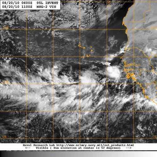
invest_al952010.invest
FSTDA
R
U
040
010
0000
201008201122
NONE
NOTIFY=ATRP
END
INVEST, AL, L, , , , , 95, 2010, DB, O, 2010082006, 9999999999, , , , , , METWATCH, , AL952010
AL, 95, 2010081912, , BEST, 0, 110N, 236W, 25, 1009, DB, 0, , 0, 0, 0, 0,
AL, 95, 2010081918, , BEST, 0, 110N, 241W, 25, 1009, DB, 0, , 0, 0, 0, 0,
AL, 95, 2010082000, , BEST, 0, 110N, 247W, 25, 1009, DB, 0, , 0, 0, 0, 0,
AL, 95, 2010082006, , BEST, 0, 110N, 253W, 25, 1008, DB


Long thread of all the discussions about this system at Talking Tropics Forum.

viewtopic.php?f=31&t=108962&hilit=&start=0
0 likes   
Visit the Caribbean-Central America Weather Thread where you can find at first post web cams,radars
and observations from Caribbean basin members Click Here

Stormhunter27
Tropical Low
Tropical Low
Posts: 41
Age: 51
Joined: Tue May 30, 2006 2:24 pm
Location: Toronto, Ontario, Canada
Contact:

#2 Postby Stormhunter27 » Fri Aug 20, 2010 6:40 am

Finally.

Now it's a matter of waiting on the models for this. However, watching the progression of the troughs across Canada this year, I have to admit I expect this one to go fish. Should be very interesting to watch the development though.

The pattern across Canada has been resembling a late fall/winter pattern for more than a week now, and I while i do anticipate a change, I think that the next trough coming through (next wek) is going to be strong enough to pick this one up and carry it north.

I've been known to be wrong however...
0 likes   

User avatar
ColinDelia
S2K Supporter
S2K Supporter
Posts: 918
Joined: Mon Aug 29, 2005 5:52 am
Location: The Beach, FL

#3 Postby ColinDelia » Fri Aug 20, 2010 6:51 am

I feel like 95L just got a lottery ticket after standing in line for a week. Not let's see if the ticket pays.
0 likes   

User avatar
ColinDelia
S2K Supporter
S2K Supporter
Posts: 918
Joined: Mon Aug 29, 2005 5:52 am
Location: The Beach, FL

#4 Postby ColinDelia » Fri Aug 20, 2010 6:53 am

Wow, 40% now.
0 likes   

User avatar
cycloneye
Admin
Admin
Posts: 139105
Age: 67
Joined: Thu Oct 10, 2002 10:54 am
Location: San Juan, Puerto Rico

Re: ATL : INVEST 95L - DISCUSSION

#5 Postby cycloneye » Fri Aug 20, 2010 6:54 am

ABNT20 KNHC 201148
TWOAT
TROPICAL WEATHER OUTLOOK
NWS TPC/NATIONAL HURRICANE CENTER MIAMI FL
800 AM EDT FRI AUG 20 2010

FOR THE NORTH ATLANTIC...CARIBBEAN SEA AND THE GULF OF MEXICO...

DISORGANIZED SHOWERS AND THUNDERSTORMS ARE ASSOCIATED WITH A
WESTWARD-MOVING TROPICAL WAVE OVER THE THE YUCATAN PENINSULA.
THERE IS A LOW CHANCE...10 PERCENT...OF TROPICAL CYCLONE FORMATION
DURING THE NEXT 48 HOURS WHILE THE SYSTEM IS OVER THE BAY OF
CAMPECHE.

A BROAD AREA OF LOW PRESSURE HAS FORMED ABOUT 275 MILES SOUTH-
SOUTHWEST OF THE CAPE VERDE ISLANDS. SHOWER AND THUNDERSTORM
ACTIVITY IS GRADUALLY BECOMING BETTER ORGANIZED...AND A TROPICAL
DEPRESSION COULD FORM DURING THE NEXT COUPLE OF DAYS. THERE IS A
MEDIUM CHANCE...40 PERCENT...OF THIS SYSTEM BECOMING A TROPICAL
CYCLONE DURING THE NEXT 48 HOURS AS IT MOVES SLOWLY WESTWARD.


ELSEWHERE...TROPICAL CYCLONE FORMATION IS NOT EXPECTED DURING THE
NEXT 48 HOURS.

$$
FORECASTER BLAKE

Image
0 likes   
Visit the Caribbean-Central America Weather Thread where you can find at first post web cams,radars
and observations from Caribbean basin members Click Here

User avatar
ColinDelia
S2K Supporter
S2K Supporter
Posts: 918
Joined: Mon Aug 29, 2005 5:52 am
Location: The Beach, FL

Re: ATL : INVEST 95L - DISCUSSION

#6 Postby ColinDelia » Fri Aug 20, 2010 7:01 am

Vorticity in the top map.

Image
Image
0 likes   

User avatar
wxman57
Moderator-Pro Met
Moderator-Pro Met
Posts: 22482
Age: 66
Joined: Sat Jun 21, 2003 8:06 pm
Location: Houston, TX (southwest)

Re: ATL : INVEST 95L - DISCUSSION

#7 Postby wxman57 » Fri Aug 20, 2010 7:14 am

I'd give this one a 100% chance of developing (beyond 48 hrs) now. It's about as sure a thing as we ever see out there. Still looks most likely to be a fish, but I don't trust the long-range models' forecast out there as far as the strength of the ridge to the north.
0 likes   

User avatar
ColinDelia
S2K Supporter
S2K Supporter
Posts: 918
Joined: Mon Aug 29, 2005 5:52 am
Location: The Beach, FL

#8 Postby ColinDelia » Fri Aug 20, 2010 7:21 am

I know it hasn't formed yet and assume it will .. but it's been really cool watching the models improve at tropical cyclogenesis over the years. Still a long ways to go but they've also come a long way.
0 likes   

User avatar
srainhoutx
S2K Supporter
S2K Supporter
Posts: 6919
Age: 66
Joined: Sun Jan 14, 2007 11:34 am
Location: Haywood County, NC
Contact:

Re: ATL : INVEST 95L - DISCUSSION

#9 Postby srainhoutx » Fri Aug 20, 2010 7:25 am

After days of model watching, debate, and merged threads we finally have an Invest. I suspect we may see some screensaver images in the days ahead...

Image
0 likes   
Carla/Alicia/Jerry(In The Eye)/Michelle/Charley/Ivan/Dennis/Katrina/Rita/Wilma/Ike/Harvey

Member: National Weather Association
Wx Infinity Forums
http://wxinfinity.com/index.php

Facebook.com/WeatherInfinity
Twitter @WeatherInfinity

Aric Dunn
Category 5
Category 5
Posts: 21228
Age: 41
Joined: Sun Sep 19, 2004 9:58 pm
Location: Ready for the Chase.
Contact:

#10 Postby Aric Dunn » Fri Aug 20, 2010 7:49 am

So this means I dont have to read a bunch of posts on the models now :) yay !!! lol
0 likes   

Aric Dunn
Category 5
Category 5
Posts: 21228
Age: 41
Joined: Sun Sep 19, 2004 9:58 pm
Location: Ready for the Chase.
Contact:

#11 Postby Aric Dunn » Fri Aug 20, 2010 7:51 am

well I will say one thing about the models.. at least the 00z and 06z gfs... it had better not miss the weakness because it builds in a very substantial ridge extending across the atlantic now rather than a series of troughs.. and im going to disregard the EURO at the 00z.. it developing a couple spurious lows that dont look realistic
0 likes   

canes04
Category 1
Category 1
Posts: 296
Joined: Sat May 22, 2004 5:41 pm
Location: Miami, FL

Re: ATL : INVEST 95L - DISCUSSION

#12 Postby canes04 » Fri Aug 20, 2010 7:56 am

Aric,

I noticed that as well. Also it's at 11n and moving slowly west.
I'm still not sold on the recurve. If it was Sept 20 I would buy it.

One thing for sure, this has great potential!
0 likes   

Aric Dunn
Category 5
Category 5
Posts: 21228
Age: 41
Joined: Sun Sep 19, 2004 9:58 pm
Location: Ready for the Chase.
Contact:

#13 Postby Aric Dunn » Fri Aug 20, 2010 8:00 am

well thats going to be interesting.. the area farther east i was talking about yesterday has quite a decent circ developing as well ... looks like we are going to get some rotating around each other.. maybe the NOGAPS was on to something with the crazy merging..

http://oiswww.eumetsat.org/IPPS/html/MS ... /index.htm
0 likes   
Note: If I make a post that is brief. Please refer back to previous posts for the analysis or reasoning. I do not re-write/qoute what my initial post said each time.
If there is nothing before... then just ask :)

Space & Atmospheric Physicist, Embry-Riddle Aeronautical University,
I believe the sky is falling...

hurricaneCW
Category 5
Category 5
Posts: 1773
Joined: Wed Mar 03, 2010 6:20 am
Location: Toms River, NJ

Re: ATL : INVEST 95L - DISCUSSION

#14 Postby hurricaneCW » Fri Aug 20, 2010 8:08 am

Perhaps if the system moves slower than models suggest, than it might have a chance to miss the weakness but odds are very slim at this point. Looks like a nice storm will be developing finally though. Strong chance at a major.
0 likes   

User avatar
x-y-no
Category 5
Category 5
Posts: 8359
Age: 63
Joined: Wed Aug 11, 2004 12:14 pm
Location: Fort Lauderdale, FL

#15 Postby x-y-no » Fri Aug 20, 2010 8:11 am

The wave behind it has some mid-level spin and is close enough for significant interaction. I think that will help keep this tracking more due west for the next day or two. But when this gets organized, its outflow will shred the trailing wave in short order.
0 likes   

Aric Dunn
Category 5
Category 5
Posts: 21228
Age: 41
Joined: Sun Sep 19, 2004 9:58 pm
Location: Ready for the Chase.
Contact:

Re: ATL : INVEST 95L - DISCUSSION

#16 Postby Aric Dunn » Fri Aug 20, 2010 8:11 am

close up visible..

Image
Last edited by Aric Dunn on Fri Aug 20, 2010 8:20 am, edited 1 time in total.
0 likes   

User avatar
cycloneye
Admin
Admin
Posts: 139105
Age: 67
Joined: Thu Oct 10, 2002 10:54 am
Location: San Juan, Puerto Rico

Re: ATL : INVEST 95L - DISCUSSION

#17 Postby cycloneye » Fri Aug 20, 2010 8:13 am

12z Best Track

AL, 95, 2010082012, , BEST, 0, 110N, 260W, 25, 1008, DB

ftp://ftp.tpc.ncep.noaa.gov/atcf/tcweb/ ... 010.invest


Strait westward.
0 likes   
Visit the Caribbean-Central America Weather Thread where you can find at first post web cams,radars
and observations from Caribbean basin members Click Here

Aric Dunn
Category 5
Category 5
Posts: 21228
Age: 41
Joined: Sun Sep 19, 2004 9:58 pm
Location: Ready for the Chase.
Contact:

Re:

#18 Postby Aric Dunn » Fri Aug 20, 2010 8:13 am

x-y-no wrote:The wave behind it has some mid-level spin and is close enough for significant interaction. I think that will help keep this tracking more due west for the next day or two. But when this gets organized, its outflow will shred the trailing wave in short order.


yeah it will have a effect on it for sure .... and its quite a bit smaller so should eventually be absorbed... also surface obs indicate that there is a surface reflection associated with it ...

Image
0 likes   
Note: If I make a post that is brief. Please refer back to previous posts for the analysis or reasoning. I do not re-write/qoute what my initial post said each time.
If there is nothing before... then just ask :)

Space & Atmospheric Physicist, Embry-Riddle Aeronautical University,
I believe the sky is falling...

User avatar
Buck
Category 5
Category 5
Posts: 1128
Joined: Fri Sep 10, 2004 12:04 pm
Location: Atlanta, GA

#19 Postby Buck » Fri Aug 20, 2010 8:22 am

I hate to get my hopes up after this season so far... but it's looking pretty good. A long tracker should would be nice.
0 likes   

User avatar
ColinDelia
S2K Supporter
S2K Supporter
Posts: 918
Joined: Mon Aug 29, 2005 5:52 am
Location: The Beach, FL

Re: ATL : INVEST 95L - DISCUSSION

#20 Postby ColinDelia » Fri Aug 20, 2010 8:27 am

Aric Dunn wrote:close up visible..

http://img826.imageshack.us/img826/9872/movie.gif


Aric,

What is the link for where I can find this "movie"?

Thanks
0 likes   


Return to “2010”

Who is online

Users browsing this forum: No registered users and 35 guests