ATL: OTTO - Models

Moderator: S2k Moderators

Message
Author
User avatar
HURAKAN
Professional-Met
Professional-Met
Posts: 46086
Age: 37
Joined: Thu May 20, 2004 4:34 pm
Location: Key West, FL
Contact:

ATL: OTTO - Models

#1 Postby HURAKAN » Thu Sep 30, 2010 4:51 am

Code: Select all

140
WHXX01 KWBC 300745
CHGHUR
TROPICAL CYCLONE GUIDANCE MESSAGE
NWS TPC/NATIONAL HURRICANE CENTER MIAMI FL
0745 UTC THU SEP 30 2010
 
DISCLAIMER...NUMERICAL MODELS ARE SUBJECT TO LARGE ERRORS.
PLEASE REFER TO NHC OFFICIAL FORECASTS FOR TROPICAL CYCLONE
AND SUBTROPICAL CYCLONE INFORMATION.
 
ATLANTIC OBJECTIVE AIDS FOR
 
DISTURBANCE INVEST (AL972010) 20100930 0600 UTC
 
        ...00 HRS...   ...12 HRS...   ...24 HRS. ..   ...36 HRS...
        100930  0600   100930  1800   101001  0600   101001  1800
 
         LAT    LON     LAT    LON     LAT    LON     LAT    LON
BAMS    13.1N  43.2W   14.1N  47.0W   15.2N  50.4W   16.4N  53.4W
BAMD    13.1N  43.2W   13.9N  46.0W   15.0N  48.7W   16.3N  51.0W
BAMM    13.1N  43.2W   13.8N  46.5W   15.0N  49.7W   16.3N  52.3W
LBAR    13.1N  43.2W   13.9N  46.3W   14.9N  49.5W   16.0N  52.3W
SHIP        25KTS          29KTS          35KTS          42KTS
DSHP        25KTS          29KTS          35KTS          42KTS
 
        ...48 HRS...   ...72 HRS...   ...96 HRS. ..   ..120 HRS...
        101002  0600   101003  0600   101004  0600   101005  0600
 
         LAT    LON     LAT    LON     LAT    LON     LAT    LON
BAMS    17.4N  56.2W   19.3N  60.6W   20.0N  64.7W   20.4N  68.0W
BAMD    17.2N  52.7W   17.9N  54.5W   18.6N  56.3W   20.1N  59.2W
BAMM    17.2N  54.5W   18.6N  57.6W   19.5N  60.5W   20.8N  63.5W
LBAR    16.9N  54.9W   18.1N  59.0W   18.5N  61.5W   18.6N  62.3W
SHIP        48KTS          56KTS          57KTS          60KTS
DSHP        48KTS          56KTS          57KTS          60KTS
 
         ...INITIAL CONDITIONS...
LATCUR =  13.1N LONCUR =  43.2W DIRCUR = 275DEG SPDCUR =  19KT
LATM12 =  12.9N LONM12 =  39.4W DIRM12 = 274DEG SPDM12 =  19KT
LATM24 =  12.7N LONM24 =  35.6W
WNDCUR =   25KT RMAXWD =   60NM WNDM12 =   20KT
CENPRS = 1009MB OUTPRS = 1012MB OUTRAD =  150NM SDEPTH =   S
RD34NE =    0NM RD34SE =    0NM RD34SW =    0NM RD34NW =   0NM
 
$$
NNNN


Image
0 likes   

User avatar
GCANE
S2K Supporter
S2K Supporter
Posts: 10787
Joined: Mon Oct 22, 2007 8:03 am

Re: ATL : INVEST 97L - Models

#2 Postby GCANE » Thu Sep 30, 2010 6:56 am

Image

Image
0 likes   

User avatar
GCANE
S2K Supporter
S2K Supporter
Posts: 10787
Joined: Mon Oct 22, 2007 8:03 am

Re: ATL : INVEST 97L - Models

#3 Postby GCANE » Thu Sep 30, 2010 7:01 am

Euro 144 hrs

Image
0 likes   

User avatar
srainhoutx
S2K Supporter
S2K Supporter
Posts: 6919
Age: 66
Joined: Sun Jan 14, 2007 11:34 am
Location: Haywood County, NC
Contact:

Re: ATL : INVEST 97L - Models

#4 Postby srainhoutx » Thu Sep 30, 2010 7:54 am

From PREDICT...

PREDICT Ensemble Discussion

--------------------------------------------------------------------------------
Date(UTC): 2010/09/30 11:32
Author: Ryan Torn
Submitted at(UTC): 2010/09/30 12:00
--------------------------------------------------------------------------------

Current Conditions/Review of Yesterday's Forecast:
NHC upgraded TD16 to TS Nicole at 1500 UTC yesterday; however,
by 2100 UTC this system was downgraded to a non-tropical system
and will not be discussed here. PGI48L and PGI51L appear to
have merged together and are now designated PGI51L. The
ensemble has been predicting for this system to get close to
genesis criteria for the past three forecast cycles, though to
date, there does not appear to be any increase in the
circulation of this system during the past couple of days,
though there is plenty of convection. The initial position of
this system within the ensemble is just to the north of the
consensus. PGI49L has not shown much sign of getting better
organized since moving off the African coast. The ensemble has
been more bearish about the development of this system relative
to PGI51L because it encounters more shear as it moves to the
NW. The ensemble has the pouch fairly close to the consensus at
the initial time, but there is a lot of spread.

--------------------------------------------------------------------------------

DAY 1 (Next 24 hours) Outlook:
PGI49L continues to move to the northwest during the first
period of the forecast, with position variance stretched in the
E-W direction. There is a slow increase in the midtropospheric
circulation in all ensemble members; however, the OW values
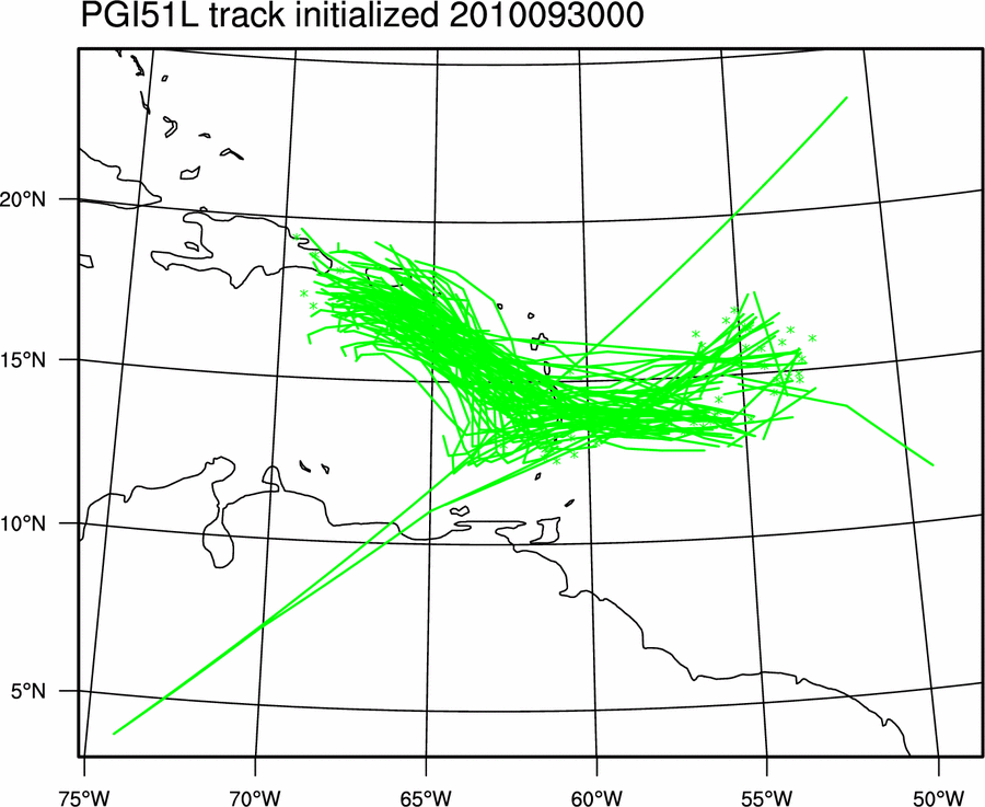
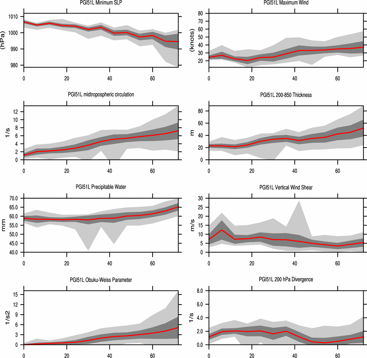
remain nearly constant and near 1. PGI51L is predicted to be
over the windward islands by 24 h, with larger position variance
stretched in the NE-SW direction. The circulation values
associated with this system are predicted to nearly double
during this 24 h period, with the OW values becoming much
greater than zero.

--------------------------------------------------------------------------------

DAY 2 (24 - 48 hours) Outlook:
PGI49L continues to drift to the NW during this period, with the
ensemble-mean position near 17N 51W at 48 h, with large variance
stretched in the E-W direction. The circulation values continue
to increase during this period, with a few of the extreme
members reaching circulation and thickness genesis criteria by
the end of the period. PGI51L is forecast to be in the
Caribbean sea just to the south of the Virgin Islands by 48 h.
The position variance is stretched in the NW-SE direction during
this period. All of the members show continued strengthening of
this system during the period, though some members start to
level off the circulation values well below genesis criteria.
The minimum pressures associated with this system continue to
fall in all members.

--------------------------------------------------------------------------------

Extended Outlook:
PGI49L continues along the same NW trajectory, with a large
amount of position variance in the along-track direction. The
circulation values continue to increase in the ensemble mean,
nearly reaching genesis criteria by 72 h, though there is a
large amount of spread with some members decaying by 72 h and
others showing a robust TS. This is an excellent case for
initial condition sensitivity calculations given the large
uncertainty. PGI51L is nearly stationary during this period,
with some slow drift to the NW toward Hispaniola and Puerto
Rico. The position variance is stretched in the E-W direction
within the ensemble. The ensemble-mean circulation and
thickness anomaly values continue to increase during this period
and both exceed genesis criteria by 72 h. There are also a
number of members that predict these two metrics will remain
below genesis criteria, so this is also an uncertain forecast,
though it should be noted that the ensemble has been aggressive
with trying to develop this into a TD for the past three days,
thus I am not sure how much I trust this forecast.
0 likes   
Carla/Alicia/Jerry(In The Eye)/Michelle/Charley/Ivan/Dennis/Katrina/Rita/Wilma/Ike/Harvey

Member: National Weather Association
Wx Infinity Forums
http://wxinfinity.com/index.php

Facebook.com/WeatherInfinity
Twitter @WeatherInfinity

MWatkins
S2K Supporter
S2K Supporter
Posts: 2574
Joined: Sat Oct 12, 2002 7:51 pm
Location: SE Florida
Contact:

Re: ATL : INVEST 97L - Models

#5 Postby MWatkins » Thu Sep 30, 2010 8:08 am

Will be very interesting to see the 12Z early cycle guidance with the center out at 12.0N 48.5W instead of 300NM ENE of there like it was at 06Z.

Could be a track into the Caribbean (again) but with the system that far south, upper level winds are going to be fairly favorable for development.

MW
0 likes   
Updating on the twitter now: http://www.twitter.com/@watkinstrack

otowntiger
Category 5
Category 5
Posts: 1787
Joined: Tue Aug 31, 2004 7:06 pm
Location: Orlando

Re: ATL : INVEST 97L - Models

#6 Postby otowntiger » Thu Sep 30, 2010 8:37 am

GCANE wrote:Euro 144 hrs


At that particular point in this model run it looks to me that after the 'storm' has passed or emerged from the BVI and PR that it would likely then re-curve north and northeast due to what looks like a frontal boundary just off the east coast. Am I correct in seeing that. Again I realize its a longs ways off and these long term models are just for entertainment but just curious what the hypothetical situation is.
0 likes   

User avatar
Vortex
S2K Supporter
S2K Supporter
Posts: 4644
Age: 52
Joined: Fri Aug 01, 2003 9:34 pm
Location: Hilton Head, SC

Re: ATL : INVEST 97L - Models

#7 Postby Vortex » Thu Sep 30, 2010 9:09 am

0 likes   

jlauderdal
S2K Supporter
S2K Supporter
Posts: 6771
Joined: Wed May 19, 2004 5:46 am
Location: NE Fort Lauderdale
Contact:

Re: ATL : INVEST 97L - Models

#8 Postby jlauderdal » Thu Sep 30, 2010 9:36 am

Vortex wrote:00Z Ukmet s of DR in 5 days..


http://raleighwx.easternuswx.com/models ... cal120.gif


yet another very broad area of low pressure
0 likes   

MWatkins
S2K Supporter
S2K Supporter
Posts: 2574
Joined: Sat Oct 12, 2002 7:51 pm
Location: SE Florida
Contact:

#9 Postby MWatkins » Thu Sep 30, 2010 9:40 am

At this point I wonder if there are transmission problems. With best track updated, they generally would have run the models by now....

MW
0 likes   
Updating on the twitter now: http://www.twitter.com/@watkinstrack

jlauderdal
S2K Supporter
S2K Supporter
Posts: 6771
Joined: Wed May 19, 2004 5:46 am
Location: NE Fort Lauderdale
Contact:

Re: ATL : INVEST 97L - Models

#10 Postby jlauderdal » Thu Sep 30, 2010 9:40 am

MWatkins wrote:Will be very interesting to see the 12Z early cycle guidance with the center out at 12.0N 48.5W instead of 300NM ENE of there like it was at 06Z.

Could be a track into the Caribbean (again) but with the system that far south, upper level winds are going to be fairly favorable for development.

MW

be interesting to see a system get its start that far east make it so far west but underneath that ridge and a start so far south its certainly in the cards
0 likes   

User avatar
KWT
Category 5
Category 5
Posts: 31390
Joined: Tue Aug 17, 2004 11:02 am
Location: UK!!!

#11 Postby KWT » Thu Sep 30, 2010 9:44 am

Yeah its a little unusual for a system this far east to be a threat but I think its quite clear that at least a broad low will develop from this and move through the Caribbean possibly curving up through the Bahamas down the line looking at the models.

Will be very interesting to see the 12z models and how they portray things to occur...
0 likes   
Personal Forecast Disclaimer:
The posts in this forum are NOT official forecast and should not be used as such. They are just the opinion of the poster and may or may not be backed by sound meteorological data. They are NOT endorsed by any professional institution or storm2k.org. For official information, please refer to the NHC and NWS products

User avatar
cycloneye
Admin
Admin
Posts: 139104
Age: 67
Joined: Thu Oct 10, 2002 10:54 am
Location: San Juan, Puerto Rico

Re: ATL : INVEST 97L - Models

#12 Postby cycloneye » Thu Sep 30, 2010 10:08 am

12z NAM

Image
0 likes   
Visit the Caribbean-Central America Weather Thread where you can find at first post web cams,radars
and observations from Caribbean basin members Click Here

User avatar
Typhoon_Willie
Category 5
Category 5
Posts: 1042
Joined: Mon Jun 09, 2003 3:19 pm
Location: Greenacres City, Florida

Re: ATL : INVEST 97L - Models

#13 Postby Typhoon_Willie » Thu Sep 30, 2010 10:17 am

Yes it will be interesting to see where this goes. So far it looks like it could be trouble, but it is early in the game yet.
0 likes   

User avatar
cycloneye
Admin
Admin
Posts: 139104
Age: 67
Joined: Thu Oct 10, 2002 10:54 am
Location: San Juan, Puerto Rico

Re: ATL : INVEST 97L - Models

#14 Postby cycloneye » Thu Sep 30, 2010 12:07 pm

0 likes   
Visit the Caribbean-Central America Weather Thread where you can find at first post web cams,radars
and observations from Caribbean basin members Click Here

User avatar
GCANE
S2K Supporter
S2K Supporter
Posts: 10787
Joined: Mon Oct 22, 2007 8:03 am

Re: ATL : INVEST 97L - Models

#15 Postby GCANE » Thu Sep 30, 2010 12:10 pm

cycloneye wrote:12z Canadian is very bullish.

http://moe.met.fsu.edu/cgi-bin/cmctc2.c ... =Animation


With the possible East CONUS Block next week, could be plausible.
0 likes   

dwsqos2

Re: ATL : INVEST 97L - Models

#16 Postby dwsqos2 » Thu Sep 30, 2010 12:23 pm

12Z gfs is very meager.
0 likes   

User avatar
FireRat
Category 5
Category 5
Posts: 1138
Age: 36
Joined: Sun Sep 26, 2010 11:38 pm
Location: North Carolina

#17 Postby FireRat » Thu Sep 30, 2010 12:28 pm

97 enters Caribbean: Trouble by October 3 and something related for the 7th-9th (Florida or Southeast.)

97 passes above Lesser Antilles: Likely to recurve as a fish, it's rare to have October hits from the east when the storms track above the island of Puerto Rico. Caribbean storms have higher potential including northbound storms like King and Hazel in the 50s.
0 likes   
Georges '98, Irene '99, Frances '04, Jeanne '04, Katrina '05, Wilma '05, Gustav '08, Isaac '12, Matthew '16, Florence '18, Michael '18, Ian '22

User avatar
Vortex
S2K Supporter
S2K Supporter
Posts: 4644
Age: 52
Joined: Fri Aug 01, 2003 9:34 pm
Location: Hilton Head, SC

ATL: INVEST 97L - Discussion - (Code Orange)

#18 Postby Vortex » Thu Sep 30, 2010 1:25 pm

0 likes   

User avatar
Vortex
S2K Supporter
S2K Supporter
Posts: 4644
Age: 52
Joined: Fri Aug 01, 2003 9:34 pm
Location: Hilton Head, SC

#19 Postby Vortex » Thu Sep 30, 2010 1:25 pm

H120 just south of PR and strengthening...


http://raleighwx.easternuswx.com/models ... SLP120.gif
0 likes   

User avatar
cycloneye
Admin
Admin
Posts: 139104
Age: 67
Joined: Thu Oct 10, 2002 10:54 am
Location: San Juan, Puerto Rico

Re: ATL : INVEST 97L - Models

#20 Postby cycloneye » Thu Sep 30, 2010 1:27 pm

The Tropical Model Bams have not been updated since the first run at 06z.
0 likes   
Visit the Caribbean-Central America Weather Thread where you can find at first post web cams,radars
and observations from Caribbean basin members Click Here


Return to “2010”

Who is online

Users browsing this forum: No registered users and 28 guests