ATL : EX TOMAS - Discussion
Moderator: S2k Moderators
-
hurricaneCW
- Category 5

- Posts: 1773
- Joined: Wed Mar 03, 2010 6:20 am
- Location: Toms River, NJ
Re: ATL : TOMAS - Hurricane - Discussion
The worst of Tomas should spare Haiti except maybe the extreme NW part of Haiti but they will still get a strong brush by with heavy rains that will exacerbate the cholera crises. Interestingly enough, Tomas may never landfall in Cuba, Haiti, or the Bahamas. He found a small gap and is moving through it. The SE Bahamas may actually see the worst impacts since Tomas could pass very close if not over them.
0 likes

Re: ATL : TOMAS - Hurricane - Discussion
STORMCARIB REPORT FROM HAITI:
* By rudy victor <rudyvictor at yahoo.com>
* Date: Fri, 5 Nov 2010 05:02:28 -0700 (PDT)
good morning from port au prince !its been rainning on and off since yesterday
night .Here in port au prince wind is blowing between 15 to 20 miles an hour
with some higher gust but theres has been report of two casualties in croix des
bouquets, a city east north east of port au prince and in the southwest part of
the country, both people were drown in flooding rivers.the situation will get
tougher as tomas enter the gulf of la gonave and take aim at the north and
western part of the country.
rudolph victor
0 likes
Too many hurricanes to remember

Re: ATL : TOMAS - Hurricane - Discussion
hurricaneCW wrote:The worst of Tomas should spare Haiti except maybe the extreme NW part of Haiti but they will still get a strong brush by with heavy rains that will exacerbate the cholera crises. Interestingly enough, Tomas may never landfall in Cuba, Haiti, or the Bahamas. He found a small gap and is moving through it. The SE Bahamas may actually see the worst impacts since Tomas could pass very close if not over them.
The problem is the core is quite flabby and large so the heaviest convection is over W.Haiti right now, the most badly hit areas from the earthquaks may just be far enough east not to get the worst of the conditions thankfully...
0 likes
Personal Forecast Disclaimer:
The posts in this forum are NOT official forecast and should not be used as such. They are just the opinion of the poster and may or may not be backed by sound meteorological data. They are NOT endorsed by any professional institution or storm2k.org. For official information, please refer to the NHC and NWS products
The posts in this forum are NOT official forecast and should not be used as such. They are just the opinion of the poster and may or may not be backed by sound meteorological data. They are NOT endorsed by any professional institution or storm2k.org. For official information, please refer to the NHC and NWS products
-
guyclaude08
- Tropical Low

- Posts: 39
- Joined: Thu Sep 24, 2009 8:01 am
Re: ATL : TOMAS - Hurricane - Discussion
Hello can tomas be a cat 2 near Haiti ? I'm north of DR in Santiago what can I expect there when tomas get to north to Haiti ???
0 likes

Re: ATL : TOMAS - Hurricane - Discussion
KWT wrote:The problem is the core is quite flabby and large so the heaviest convection is over W.Haiti right now, the most badly hit areas from the earthquaks may just be far enough east not to get the worst of the conditions thankfully...
One important thing to consider is that the strongest convection does not mean the heaviest precipitation in some cases especially over mountainous terrain, remember that when Mitch made landfall cloud tops had already warmed but the mountains made those relatively low clouds to produce haavy rains.
0 likes
-
HURAKAN

- Professional-Met

- Posts: 46086
- Age: 37
- Joined: Thu May 20, 2004 4:34 pm
- Location: Key West, FL
- Contact:
Re: ATL : TOMAS - Hurricane - Discussion
guyclaude08 wrote:Hello can tomas be a cat 2 near Haiti ? I'm north of DR in Santiago what can I expect there when tomas get to north to Haiti ???
It's possible if the center remains away from making landfall. In Santiago you can expect possibly heavy rainfall and some gusty winds but the worse will stay away from your area.
ONAMET - http://www.onamet.gov.do/historial.php?s=tiempo&id=9421
0 likes

Re: ATL : TOMAS - Hurricane - Discussion
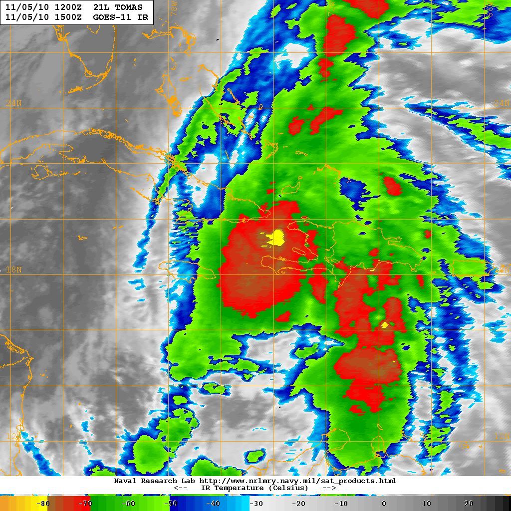
looks like a strong band and maybe the heaviest rainfall is to the west of Tomas trying to wrap around to the south as detailed by recon
http://www.insmet.cu/asp/genesis.asp?TB0=PLANTILLAS&TB1=RADAR&TB2=../Radar/NacComp200Km.gif
http://www.insmet.cu/asp/genesis.asp?TB0=PLANTILLAS&TB1=RADAR&TB2=../Radar/NacComp200Km.gif
0 likes
-
wxman57

- Moderator-Pro Met

- Posts: 22482
- Age: 66
- Joined: Sat Jun 21, 2003 8:06 pm
- Location: Houston, TX (southwest)
Re: ATL : TOMAS - Hurricane - Discussion
guyclaude08 wrote:Hello can tomas be a cat 2 near Haiti ? I'm north of DR in Santiago what can I expect there when tomas get to north to Haiti ???
Tomas will pass a good 175 miles to your west, so you won't feel any significant wind in Santiago. Tomas' hurricane force winds extend only about 15 miles from the center. Expect winds of around 15 mph there in Santiago, along with bands of heavy rain through the next 24 hours.
0 likes
-
HURAKAN
- Professional-Met
- Posts: 46086
- Age: 37
- Joined: Thu May 20, 2004 4:34 pm
- Location: Key West, FL
- Contact:
Re: ATL : TOMAS - Hurricane - Discussion


microscopic eye
Last edited by HURAKAN on Fri Nov 05, 2010 8:48 am, edited 1 time in total.
0 likes
-
wxman57
- Moderator-Pro Met
- Posts: 22482
- Age: 66
- Joined: Sat Jun 21, 2003 8:06 pm
- Location: Houston, TX (southwest)
Re: ATL : TOMAS - Hurricane - Discussion
EyELeSs1 wrote:looks like a strong band and maybe the heaviest rainfall is to the west of Tomas trying to wrap around to the south as detailed by recon
http://www.insmet.cu/asp/genesis.asp?TB0=PLANTILLAS&TB1=RADAR&TB2=../Radar/NacComp200Km.gif
Keep in mind that the Cuban radar won't be able to reach all the way to Tomas' east side. In addition, beam attenuation will prevent the radar from seeing much past that western band of squalls.
0 likes

Re: ATL : TOMAS - Hurricane - Discussion
Uh-oh. Looks like an eyewall hot-tower is fixin to fire.

0 likes
Re: ATL : TOMAS - Hurricane - Discussion
Macrocane wrote:KWT wrote:The problem is the core is quite flabby and large so the heaviest convection is over W.Haiti right now, the most badly hit areas from the earthquaks may just be far enough east not to get the worst of the conditions thankfully...
One important thing to consider is that the strongest convection does not mean the heaviest precipitation in some cases especially over mountainous terrain, remember that when Mitch made landfall cloud tops had already warmed but the mountains made those relatively low clouds to produce haavy rains.
Yep thats very true and the rains will cause flooding either way, esp given the state of the ground on the campsites...
0 likes
Personal Forecast Disclaimer:
The posts in this forum are NOT official forecast and should not be used as such. They are just the opinion of the poster and may or may not be backed by sound meteorological data. They are NOT endorsed by any professional institution or storm2k.org. For official information, please refer to the NHC and NWS products
The posts in this forum are NOT official forecast and should not be used as such. They are just the opinion of the poster and may or may not be backed by sound meteorological data. They are NOT endorsed by any professional institution or storm2k.org. For official information, please refer to the NHC and NWS products
-
tolakram
- Admin

- Posts: 19165
- Age: 60
- Joined: Sun Aug 27, 2006 8:23 pm
- Location: Florence, KY (name is Mark)
Re: ATL : TOMAS - Hurricane - Discussion
LOOP: http://wwwghcc.msfc.nasa.gov/cgi-bin/ge ... umframes=5
You can almost see where the center is on visible.
You can almost see where the center is on visible.
0 likes
M a r k
- - - - -
Join us in chat: Storm2K Chatroom Invite. Android and IOS apps also available.
The posts in this forum are NOT official forecasts and should not be used as such. Posts are NOT endorsed by any professional institution or STORM2K.org. For official information and forecasts, please refer to NHC and NWS products.
Re: ATL : TOMAS - Hurricane - Discussion
Great news. Looks like the high rain-rate cell is dissipating quickly. No hot-tower.

0 likes

Re: ATL : TOMAS - Hurricane - Discussion
A small hurricane with hurricane winds extending 15 miles from the center threading the Windward Passage.
The question is how much rain it dumps on Haiti. Worst bands have stayed west of Port Au Prince so far.
The question is how much rain it dumps on Haiti. Worst bands have stayed west of Port Au Prince so far.
0 likes
-
wxman57
- Moderator-Pro Met
- Posts: 22482
- Age: 66
- Joined: Sat Jun 21, 2003 8:06 pm
- Location: Houston, TX (southwest)
Re: ATL : TOMAS - Hurricane - Discussion
I think that Tomas has already passed its peak intensity. I don't buy the NHC forecast to Cat 2 tonight. Cloud tops are already warming and outflow is being impeded by the approaching front just to its west.
0 likes
-
srainhoutx

- S2K Supporter

- Posts: 6919
- Age: 66
- Joined: Sun Jan 14, 2007 11:34 am
- Location: Haywood County, NC
- Contact:
Re: ATL : TOMAS - Hurricane - Discussion
Cloud tops cooling again...
0 likes
Carla/Alicia/Jerry(In The Eye)/Michelle/Charley/Ivan/Dennis/Katrina/Rita/Wilma/Ike/Harvey
Member: National Weather Association
Wx Infinity Forums
http://wxinfinity.com/index.php
Facebook.com/WeatherInfinity
Twitter @WeatherInfinity
Member: National Weather Association
Wx Infinity Forums
http://wxinfinity.com/index.php
Facebook.com/WeatherInfinity
Twitter @WeatherInfinity
-
wxman57
- Moderator-Pro Met
- Posts: 22482
- Age: 66
- Joined: Sat Jun 21, 2003 8:06 pm
- Location: Houston, TX (southwest)
Re: ATL : TOMAS - Hurricane - Discussion
Step back and look at the big picture now (on satellite). The cold front has reached Jamaica and the western periphery of Tomas. Outflow is becoming severely restricted. General convection is decreasing quickly. I don't think it'll last as a TC for more than another 24-36 hours.
0 likes
Who is online
Users browsing this forum: No registered users and 103 guests