ATL: INVEST 95L - Discussion
Moderator: S2k Moderators
-
- S2K Supporter
- Posts: 37123
- Age: 35
- Joined: Sun May 16, 2004 10:30 pm
- Location: Tulsa Oklahoma
- Contact:
ATL: INVEST 95L - Discussion
Yeah, I'm as speechless as the rest of you...
Last edited by Brent on Mon Dec 20, 2010 1:57 pm, edited 1 time in total.
0 likes
#neversummer
- northjaxpro
- S2K Supporter
- Posts: 8900
- Joined: Mon Sep 27, 2010 11:21 am
- Location: Jacksonville, FL
Yeah, this invest really did sneak up on us for sure!
This just goes to show that Mother Nature always can generate some sort of surprise at any time.
0 likes
NEVER, EVER SAY NEVER in the tropics and weather in general, and most importantly, with life itself!!
________________________________________________________________________________________
Fay 2008 Beryl 2012 Debby 2012 Colin 2016 Hermine 2016 Julia 2016 Matthew 2016 Irma 2017 Dorian 2019
________________________________________________________________________________________
Fay 2008 Beryl 2012 Debby 2012 Colin 2016 Hermine 2016 Julia 2016 Matthew 2016 Irma 2017 Dorian 2019
- lester
- S2K Supporter
- Posts: 1305
- Age: 35
- Joined: Sat Aug 27, 2005 5:21 pm
- Location: Washington, DC
- Contact:
BEGIN
NHC_ATCF
invest_al952010.invest
FSTDA
R
U
040
010
0000
201012201816
NONE
NOTIFY=ATRP
END
INVEST, AL, L, , , , , 95, 2010, DB, O, 2010122012, 9999999999, , , , , , METWATCH, , AL952010
AL, 95, 2010121918, , BEST, 0, 106N, 504W, 20, 1009, WV, 0, , 0, 0, 0, 0,
AL, 95, 2010122000, , BEST, 0, 107N, 516W, 20, 1009, WV, 0, , 0, 0, 0, 0,
AL, 95, 2010122006, , BEST, 0, 109N, 528W, 20, 1009, WV, 0, , 0, 0, 0, 0,
AL, 95, 2010122012, , BEST, 0, 112N, 540W, 20, 1009, DB, 0, , 0, 0, 0, 0,
AL, 95, 2010122018, , BEST, 0, 116N, 551W, 25, 1008, LO, 34, NEQ, 0, 0, 0, 0, 1011, 150, 20, 0, 0, L, 0, , 0, 0, INVEST, M,
0 likes
-
- Professional-Met
- Posts: 33393
- Joined: Tue Mar 07, 2006 11:57 pm
- Location: Deep South, for the first time!
Re: ATL: Invest 95L
Convection is pretty modest (but impressive for the week before Christmas). Can't tell if there is a closed circulation under there.
0 likes
Re: ATL: Invest 95L
Whaaaaaaaaaaaaaaaat.
I had a feeling we'd get one more oddball invest before the year was out. Come on Virginie.
0 likes
- Hurricanehink
- S2K Supporter
- Posts: 2023
- Joined: Sun Nov 16, 2003 2:05 pm
- Location: New Jersey
Re: ATL: Invest 95L
From the TWD:
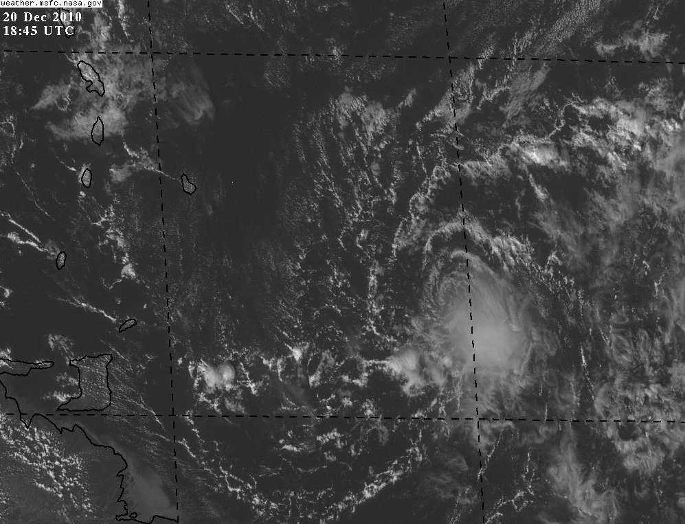
A SURFACE TROUGH WITH AN EMBEDDED SURFACE LOW EXTENDS FROM 13N53W THROUGH
THE LOW CENTER NEAR 11N54W TO INLAND OVER SURINAME NEAR 6N56W.
CLUSTERS OF SCATTERED MODERATE TO ISOLATED STRONG CONVECTION ARE
FROM 9N-13N BETWEEN 48W AND 55W WITH MOSTLY SCATTERED SHOWERS
AND ALONG THE COAST OF SURINAME S OF 7N BETWEEN 54W AND 56W.
0 likes
-
- Admin
- Posts: 19167
- Age: 60
- Joined: Sun Aug 27, 2006 8:23 pm
- Location: Florence, KY (name is Mark)
Re: ATL: Invest 95L
0 likes
M a r k
- - - - -
Join us in chat: Storm2K Chatroom Invite. Android and IOS apps also available.
The posts in this forum are NOT official forecasts and should not be used as such. Posts are NOT endorsed by any professional institution or STORM2K.org. For official information and forecasts, please refer to NHC and NWS products.
- cycloneye
- Admin
- Posts: 139212
- Age: 67
- Joined: Thu Oct 10, 2002 10:54 am
- Location: San Juan, Puerto Rico
Re: Re:
Cyclone1 wrote:RL3AO wrote:Um is it that Spanish April Fool's day yet? I know its this time of year.
Not yet. That's the 28th I believe.
Yup,I am also speeachless.
0 likes
Visit the Caribbean-Central America Weather Thread where you can find at first post web cams,radars
and observations from Caribbean basin members Click Here
Re: ATL: Invest 95L
CrazyC83 wrote:Convection is pretty modest (but impressive for the week before Christmas). Can't tell if there is a closed circulation under there.
If it is designated as a low, then by definition there is (believed to be) a closed surface circulation.
What does the "DB" stand for in the operational best track file on this invest? I am drawing a blank for "DB."
Margie
Last edited by margiek on Mon Dec 20, 2010 3:35 pm, edited 2 times in total.
0 likes
-
- Professional-Met
- Posts: 33393
- Joined: Tue Mar 07, 2006 11:57 pm
- Location: Deep South, for the first time!
Re: ATL: Invest 95L
margiek wrote:CrazyC83 wrote:Convection is pretty modest (but impressive for the week before Christmas). Can't tell if there is a closed circulation under there.
If it is designated as a low, then by definition there is (believed to be) a closed surface circulation.
What does the "DB" stand for in the operational best track file on this invest? I am drawing a blank for "DB."
Margie
DB = Disturbance.
0 likes
Re: ATL: Invest 95L
CrazyC83 wrote:margiek wrote:CrazyC83 wrote:Convection is pretty modest (but impressive for the week before Christmas). Can't tell if there is a closed circulation under there.
If it is designated as a low, then by definition there is (believed to be) a closed surface circulation.
What does the "DB" stand for in the operational best track file on this invest? I am drawing a blank for "DB."
Margie
DB = Disturbance.
Thank you.
ASCAT from this morning showed a well-defined tropical wave, not a surface low at that time, but that is the time it was upgraded to disturbance, probably the convection that has since gone poof.
0 likes
-
- Professional-Met
- Posts: 33393
- Joined: Tue Mar 07, 2006 11:57 pm
- Location: Deep South, for the first time!
Re: ATL: INVEST 95L - Discussion
Code Orange. Best chance of becoming a TC is over the islands tomorrow.
000
ABNT20 KNHC 202053
TWOAT
SPECIAL TROPICAL WEATHER OUTLOOK
NWS TPC/NATIONAL HURRICANE CENTER MIAMI FL
355 PM EST MON DEC 20 2010
FOR THE NORTH ATLANTIC...CARIBBEAN SEA AND THE GULF OF MEXICO...
A SMALL BUT WELL-DEFINED LOW PRESSURE SYSTEM LOCATED ABOUT 275 MILES
EAST-SOUTHEAST OF BARBADOS IS PRODUCING SCATTERED SHOWERS OVER THE
SOUTHWESTERN TROPICAL ATLANTIC. ENVIRONMENTAL CONDITIONS ARE NOT
CONDUCIVE FOR DEVELOPMENT AT THIS TIME. HOWEVER...CONDITIONS COULD
BECOME A LITTLE MORE FAVORABLE ON TUESDAY...RESULTING IN A BRIEF
WINDOW OF OPPORTUNITY FOR SOME DEVELOPMENT AS THE LOW PASSES OVER
OR NEAR THE SOUTHERN AND CENTRAL LESSER ANTILLES. THERE IS A MEDIUM
CHANCE...30 PERCENT...OF THIS SYSTEM BECOMING A TROPICAL CYCLONE
DURING THE NEXT 48 HOURS AS IT MOVES TOWARD THE WEST-NORTHWEST OR
NORTH WEST AT 10 TO 15 MPH. REGARDLESS OF DEVELOPMENT...THIS SYSTEM
WILL BRING LOCALLY HEAVY RAINFALL AND GUSTY WINDS TO MUCH OF THE
LESSER ANTILLES DURING THE NEXT DAY OR SO.
FUTURE SPECIAL TROPICAL WEATHER OUTLOOKS WILL BE ISSUED AS
CONDITIONS WARRANT. ADDITIONAL INFORMATION ON THIS SYSTEM CAN BE
FOUND IN HIGH SEAS FORECASTS ISSUED BY THE NATIONAL WEATHER
SERVICE...UNDER AWIPS HEADER NFDHSFAT1 AND WMO HEADER FZNT01 KWBC.
ELSEWHERE...TROPICAL CYCLONE FORMATION IS NOT EXPECTED DURING THE
NEXT 48 HOURS.
$$
FORECASTER STEWART/BRENNAN
0 likes
Who is online
Users browsing this forum: No registered users and 30 guests