WPAC: MUIFA (Kabayan) - Tropical Depression
Moderator: S2k Moderators
-
StormingB81

- S2K Supporter

- Posts: 5676
- Age: 44
- Joined: Thu Aug 27, 2009 1:45 am
- Location: Rockledge, Florida
-
dexterlabio
- Category 5

- Posts: 3505
- Joined: Sat Oct 24, 2009 11:50 pm
Re: WPAC: MUIFA (Kabayan) - Typhoon
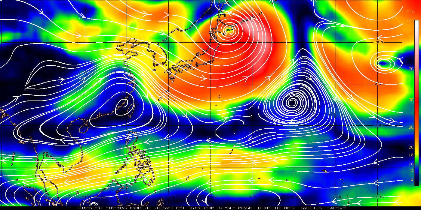
Moving slowly a bit to the WNW/NW, stair-stepping I think.
That steering layer chart would tell the slow and erratic movement being observed now.
That steering layer chart would tell the slow and erratic movement being observed now.
0 likes
Personal Forecast Disclaimer:
The posts in this forum are NOT official forecast and should not be used as such. They are just the opinion of the poster and may or may not be backed by sound meteorological data. They are NOT endorsed by any professional institution or storm2k.org. For official information, please refer to the NHC and NWS products.
The posts in this forum are NOT official forecast and should not be used as such. They are just the opinion of the poster and may or may not be backed by sound meteorological data. They are NOT endorsed by any professional institution or storm2k.org. For official information, please refer to the NHC and NWS products.
-
dexterlabio
- Category 5
- Posts: 3505
- Joined: Sat Oct 24, 2009 11:50 pm
Re: WPAC: MUIFA (Kabayan) - Typhoon


0 likes
Personal Forecast Disclaimer:
The posts in this forum are NOT official forecast and should not be used as such. They are just the opinion of the poster and may or may not be backed by sound meteorological data. They are NOT endorsed by any professional institution or storm2k.org. For official information, please refer to the NHC and NWS products.
The posts in this forum are NOT official forecast and should not be used as such. They are just the opinion of the poster and may or may not be backed by sound meteorological data. They are NOT endorsed by any professional institution or storm2k.org. For official information, please refer to the NHC and NWS products.
-
ManilaTC

- WesternPacificWeather.com

- Posts: 593
- Age: 47
- Joined: Mon Oct 26, 2009 5:13 am
- Location: Mandaluyong City, Philippines
- Contact:
Re: WPAC: MUIFA (Kabayan) - Typhoon

The image speaks for itself
0 likes
The above post is NOT official and should not be used as such. It is my opinion and may or may not be backed by sound meteorological data. It is not endorsed by any professional institution or storm2k.org. Please refer to your official national weather agency.
WEB http://goo.gl/JDiKXB | FB https://goo.gl/N5sIle | @ManilaTC
WEB http://goo.gl/JDiKXB | FB https://goo.gl/N5sIle | @ManilaTC
-
apocalypt-flyer
- Category 1

- Posts: 468
- Joined: Sat Aug 27, 2005 11:51 am

Re: WPAC: MUIFA (Kabayan) - Typhoon
0 likes

-
StormingB81
- S2K Supporter
- Posts: 5676
- Age: 44
- Joined: Thu Aug 27, 2009 1:45 am
- Location: Rockledge, Florida
-
phwxenthusiast
- Category 2

- Posts: 637
- Joined: Wed Mar 24, 2010 3:10 am
- Location: Holbrook, NY (Long Island)
Re:
Infdidoll wrote:Well...I guess JTWC now classifying her as Super Typhoon Muifa and don't seem to be projecting her to lose much strength as she approaches Okinawa.
no, 130kts is the Super Typhoon threshold for JTWC... although you're right, they're forecasting a peak intensity of around 135kts so definitely within that STY status... although imho, they're still a bit conservative, i mean Muifa still has about 2 days or so before it reaches the cooler waters near 23N and above... if the conditions remain favorable and the trough to the northeast fills a bit, we could see Muifa go a run at Cat 5...
The posts in this forum are NOT official forecast and should not be used as such. They are just the opinion of the poster and may or may not be backed by sound meteorological data. They are NOT endorsed by any professional institution or storm2k.org. For official information, please refer to the JMA products.
0 likes
-
dexterlabio
- Category 5
- Posts: 3505
- Joined: Sat Oct 24, 2009 11:50 pm
Re: WPAC: MUIFA (Kabayan) - Typhoon
WTPN32 PGTW 301500
MSGID/GENADMIN/NAVMARFCSTCEN PEARL HARBOR HI/JTWC//
SUBJ/TROPICAL CYCLONE WARNING//
RMKS/
1. TYPHOON 11W (MUIFA) WARNING NR 021
02 ACTIVE TROPICAL CYCLONES IN NORTHWESTPAC
MAX SUSTAINED WINDS BASED ON ONE-MINUTE AVERAGE
WIND RADII VALID OVER OPEN WATER ONLY
---
WARNING POSITION:
301200Z --- NEAR 16.5N 132.7E
MOVEMENT PAST SIX HOURS - 315 DEGREES AT 04 KTS
POSITION ACCURATE TO WITHIN 020 NM
POSITION BASED ON EYE FIXED BY SATELLITE
PRESENT WIND DISTRIBUTION:
MAX SUSTAINED WINDS - 115 KT, GUSTS 140 KT
WIND RADII VALID OVER OPEN WATER ONLY
RADIUS OF 064 KT WINDS - 040 NM NORTHEAST QUADRANT
040 NM SOUTHEAST QUADRANT
045 NM SOUTHWEST QUADRANT
040 NM NORTHWEST QUADRANT
RADIUS OF 050 KT WINDS - 080 NM NORTHEAST QUADRANT
080 NM SOUTHEAST QUADRANT
090 NM SOUTHWEST QUADRANT
080 NM NORTHWEST QUADRANT
RADIUS OF 034 KT WINDS - 120 NM NORTHEAST QUADRANT
110 NM SOUTHEAST QUADRANT
140 NM SOUTHWEST QUADRANT
120 NM NORTHWEST QUADRANT
REPEAT POSIT: 16.5N 132.7E
---
FORECASTS:
12 HRS, VALID AT:
310000Z --- 17.5N 132.4E
MAX SUSTAINED WINDS - 125 KT, GUSTS 150 KT
WIND RADII VALID OVER OPEN WATER ONLY
RADIUS OF 064 KT WINDS - 040 NM NORTHEAST QUADRANT
040 NM SOUTHEAST QUADRANT
045 NM SOUTHWEST QUADRANT
040 NM NORTHWEST QUADRANT
RADIUS OF 050 KT WINDS - 080 NM NORTHEAST QUADRANT
080 NM SOUTHEAST QUADRANT
085 NM SOUTHWEST QUADRANT
080 NM NORTHWEST QUADRANT
RADIUS OF 034 KT WINDS - 125 NM NORTHEAST QUADRANT
115 NM SOUTHEAST QUADRANT
135 NM SOUTHWEST QUADRANT
120 NM NORTHWEST QUADRANT
VECTOR TO 24 HR POSIT: 005 DEG/ 04 KTS
---
24 HRS, VALID AT:
311200Z --- 18.3N 132.5E
MAX SUSTAINED WINDS - 130 KT, GUSTS 160 KT
WIND RADII VALID OVER OPEN WATER ONLY
RADIUS OF 064 KT WINDS - 045 NM NORTHEAST QUADRANT
045 NM SOUTHEAST QUADRANT
045 NM SOUTHWEST QUADRANT
040 NM NORTHWEST QUADRANT
RADIUS OF 050 KT WINDS - 075 NM NORTHEAST QUADRANT
080 NM SOUTHEAST QUADRANT
080 NM SOUTHWEST QUADRANT
075 NM NORTHWEST QUADRANT
RADIUS OF 034 KT WINDS - 125 NM NORTHEAST QUADRANT
120 NM SOUTHEAST QUADRANT
135 NM SOUTHWEST QUADRANT
120 NM NORTHWEST QUADRANT
VECTOR TO 36 HR POSIT: 025 DEG/ 05 KTS
---
36 HRS, VALID AT:
010000Z --- 19.2N 132.9E
MAX SUSTAINED WINDS - 135 KT, GUSTS 165 KT
WIND RADII VALID OVER OPEN WATER ONLY
RADIUS OF 064 KT WINDS - 045 NM NORTHEAST QUADRANT
045 NM SOUTHEAST QUADRANT
045 NM SOUTHWEST QUADRANT
045 NM NORTHWEST QUADRANT
RADIUS OF 050 KT WINDS - 075 NM NORTHEAST QUADRANT
075 NM SOUTHEAST QUADRANT
080 NM SOUTHWEST QUADRANT
075 NM NORTHWEST QUADRANT
RADIUS OF 034 KT WINDS - 130 NM NORTHEAST QUADRANT
125 NM SOUTHEAST QUADRANT
130 NM SOUTHWEST QUADRANT
125 NM NORTHWEST QUADRANT
VECTOR TO 48 HR POSIT: 015 DEG/ 06 KTS
---
EXTENDED OUTLOOK:
48 HRS, VALID AT:
011200Z --- 20.3N 133.2E
MAX SUSTAINED WINDS - 135 KT, GUSTS 165 KT
WIND RADII VALID OVER OPEN WATER ONLY
RADIUS OF 064 KT WINDS - 045 NM NORTHEAST QUADRANT
045 NM SOUTHEAST QUADRANT
045 NM SOUTHWEST QUADRANT
045 NM NORTHWEST QUADRANT
RADIUS OF 050 KT WINDS - 075 NM NORTHEAST QUADRANT
075 NM SOUTHEAST QUADRANT
075 NM SOUTHWEST QUADRANT
075 NM NORTHWEST QUADRANT
RADIUS OF 034 KT WINDS - 130 NM NORTHEAST QUADRANT
130 NM SOUTHEAST QUADRANT
130 NM SOUTHWEST QUADRANT
130 NM NORTHWEST QUADRANT
VECTOR TO 72 HR POSIT: 350 DEG/ 06 KTS
---
72 HRS, VALID AT:
021200Z --- 22.7N 132.7E
MAX SUSTAINED WINDS - 130 KT, GUSTS 160 KT
WIND RADII VALID OVER OPEN WATER ONLY
RADIUS OF 064 KT WINDS - 045 NM NORTHEAST QUADRANT
045 NM SOUTHEAST QUADRANT
045 NM SOUTHWEST QUADRANT
045 NM NORTHWEST QUADRANT
RADIUS OF 050 KT WINDS - 075 NM NORTHEAST QUADRANT
075 NM SOUTHEAST QUADRANT
075 NM SOUTHWEST QUADRANT
075 NM NORTHWEST QUADRANT
RADIUS OF 034 KT WINDS - 135 NM NORTHEAST QUADRANT
135 NM SOUTHEAST QUADRANT
135 NM SOUTHWEST QUADRANT
135 NM NORTHWEST QUADRANT
VECTOR TO 96 HR POSIT: 335 DEG/ 05 KTS
---
LONG RANGE OUTLOOK:
NOTE...ERRORS FOR TRACK HAVE AVERAGED NEAR 250 NM
ON DAY 4 AND 350 NM ON DAY 5... AND FOR INTENSITY
NEAR 20 KT EACH DAY.
---
96 HRS, VALID AT:
031200Z --- 24.7N 131.7E
MAX SUSTAINED WINDS - 120 KT, GUSTS 145 KT
WIND RADII VALID OVER OPEN WATER ONLY
VECTOR TO 120 HR POSIT: 315 DEG/ 06 KTS
---
120 HRS, VALID AT:
041200Z --- 26.4N 129.8E
MAX SUSTAINED WINDS - 120 KT, GUSTS 145 KT
WIND RADII VALID OVER OPEN WATER ONLY
---
REMARKS:
301500Z POSITION NEAR 16.8N 132.6E.
TYPHOON (TY) 11W (MUIFA), LOCATED APPROXIMATELY 650 NM SOUTH-
SOUTHEAST OF KADENA AIR BASE, JAPAN, HAS TRACKED NORTHWESTWARD AT 04
KNOTS OVER THE PAST SIX HOURS AND HAS RAPIDLY INTENSIFIED WITHIN THE
PAST 12 HOURS. MAXIMUM SIGNIFICANT WAVE HEIGHT AT 301200Z IS 28 FEET.
NEXT WARNINGS AT 302100Z, 310300Z, 310900Z AND 311500Z. REFER TO
TROPICAL STORM 10W (NOCK-TEN) WARNINGS (WTPN31 PGTW) FOR SIX-HOURLY
UPDATES.//
NNNN
0 likes
Personal Forecast Disclaimer:
The posts in this forum are NOT official forecast and should not be used as such. They are just the opinion of the poster and may or may not be backed by sound meteorological data. They are NOT endorsed by any professional institution or storm2k.org. For official information, please refer to the NHC and NWS products.
The posts in this forum are NOT official forecast and should not be used as such. They are just the opinion of the poster and may or may not be backed by sound meteorological data. They are NOT endorsed by any professional institution or storm2k.org. For official information, please refer to the NHC and NWS products.
-
dexterlabio
- Category 5
- Posts: 3505
- Joined: Sat Oct 24, 2009 11:50 pm
Re: WPAC: MUIFA (Kabayan) - Typhoon
WDPN32 PGTW 301500
MSGID/GENADMIN/NAVMARFCSTCEN PEARL HARBOR HI/JTWC//
SUBJ/PROGNOSTIC REASONING FOR TYPHOON 11W (MUIFA) WARNING NR
21//
RMKS/
1. FOR METEOROLOGISTS.
2. 12 HOUR SUMMARY AND ANALYSIS.
A. TYPHOON (TY) 11W (MUIFA), LOCATED APPROXIMATELY 650 NM SOUTH-
SOUTHEAST OF KADENA AIR BASE, JAPAN, HAS TRACKED NORTHWESTWARD AT 04
KNOTS OVER THE PAST SIX HOURS AND HAS RAPIDLY INTENSIFIED WITHIN THE
PAST 12 HOURS. ANIMATED INFRARED SATELLITE IMAGERY SHOWS A 10 NM EYE
WITH A LARGE CONVECTIVE BAND WRAPPING AROUND THE WESTERN TO SOUTHERN
PERIPHERIES. THE INITIAL INTENSITY WAS BASED ON PGTW AND KNES DVORAK
ESTIMATES OF 115 KNOTS. WATER VAPOR IMAGERY DEPICTS EXCELLENT
EQUATORWARD OUTFLOW AND OUTFLOW INTO A TROPICAL UPPER TROPOSPHERIC
TROUGH (TUTT) TO THE NORTHWEST. HOWEVER, OUTFLOW IS SUPPRESSED ALONG
THE NORTHEASTERN PERIPHERY DUE TO AN UPPER LEVEL TROUGH ON THAT
SIDE.
3. FORECAST REASONING.
A. THE FORECAST INTENSITY IS GREATER THAN PREVIOUSLY EXPECTED DUE
TO THE RAPID INTENSIFICATION WITHIN THE PAST 12 HOURS DUE TO
IMPROVED OUTFLOW INTO A TUTT CELL TO THE NORTHWEST. ADDITIONALLY,
THE SYSTEM TURNED FARTHER TO THE NORTHWEST THAN PREVIOUSLY FORECAST.
THEREFORE THE FORECAST TRACK HAS WALKED WESTWARD SLIGHTLY.
B. TY 11W IS CURRENTLY TRACKING IN A WEAK STEERING ENVIRONMENT,
ALTHOUGH THE DOMINANT DEEP-LAYER STEERING RIDGE IS CENTERED TO THE
SOUTHEAST. THE SYSTEM IS EXPECTED TO TURN NORTHWARD WITHIN THE NEXT
12 HOURS AS THE STEERING RIDGE TO THE EAST STRENGTHENS. THE SLOWING
TRANSLATION SPEED IS ALSO AN INDICATOR OF THE TURN. TY 11W IS
FORECAST TO INTENSIFY UNDER A FAVORABLE UPPER LEVEL ENVIRONMENT AND
HIGH OCEAN HEAT CONTENT (OHC) WITHIN THE NEXT 48 HOURS. AFTER TAU
48, A SUBTROPICAL RIDGE TO THE NORTH SHOULD BUILD IN AFTER THE
PASSAGE OF A MID-LATITUDE TROUGH AND ALLOW 11W TO TURN NORTHWESTWARD.
C. THROUGH THE END OF THE FORECAST PERIOD, TY 11W IS EXPECTED TO
CONTINUE TRACKING NORTHWESTWARD TOWARD KADENA AIR BASE. AT THIS TIME
OHC WILL DROP OFF AND CAUSE SLIGHT WEAKENING OF THE SYSTEM.
NUMERICAL MODEL GUIDANCE IS SOMEWHAT SPREAD IN THE TIMING OF THE
TURN NORTHWESTWARD AFTER TAU 48. THIS FORECAST FAVORS A SHARPER TURN
TO THE NORTHWEST ALONG WITH ECMWF, UKMO, JGSM, AND NOGAPS. GFDN AND
GFS ARE THE EASTERN OUTLIERS.//
NNNN
0 likes
Personal Forecast Disclaimer:
The posts in this forum are NOT official forecast and should not be used as such. They are just the opinion of the poster and may or may not be backed by sound meteorological data. They are NOT endorsed by any professional institution or storm2k.org. For official information, please refer to the NHC and NWS products.
The posts in this forum are NOT official forecast and should not be used as such. They are just the opinion of the poster and may or may not be backed by sound meteorological data. They are NOT endorsed by any professional institution or storm2k.org. For official information, please refer to the NHC and NWS products.
Re: WPAC: MUIFA (Kabayan) - Typhoon
Sorry, that's what Weather Underground has titled it for the projected days it may affect us. Since they go off JTWC data, I took them at their word, but looks like they may just be projecting ahead. JTWC doesn't predict that title for another 24 hours. I didn't realize they do that, but hey - learn something new every day. It is misleading though.
0 likes
-
euro6208
Re: WPAC: MUIFA (Kabayan) - Typhoon
CI# /Pressure/ Vmax
6.5 / 927.6mb/127.0kt
Final T# Adj T# Raw T#
6.5 6.8 7.7
7.7 is between 155 to 170 knots 1 minute sustained!

while i am happy that jtwc is catching up with muifa, they are still really low on the intensity.
really underestimated muifa still continues to rapidly intensify with a very clear very small eye appearing in an ever improving and expanding cdo, this is clearly a category 5 with 155 knots supertyphoon with a cp of below 900.

this reminds me of Super Typhoon Rita in the 70's which bombed out at 878 millibars while in the philippine sea...
Personal Forecast Disclaimer:
The posts in this forum are NOT official forecast and should not be used as such. They are just the opinion of the poster and may or may not be backed by sound meteorological data. They are NOT endorsed by any professional institution or storm2k.org. For official information, please refer to the PAGASA, JMA, and JTWC products.
6.5 / 927.6mb/127.0kt
Final T# Adj T# Raw T#
6.5 6.8 7.7
7.7 is between 155 to 170 knots 1 minute sustained!
while i am happy that jtwc is catching up with muifa, they are still really low on the intensity.
really underestimated muifa still continues to rapidly intensify with a very clear very small eye appearing in an ever improving and expanding cdo, this is clearly a category 5 with 155 knots supertyphoon with a cp of below 900.
this reminds me of Super Typhoon Rita in the 70's which bombed out at 878 millibars while in the philippine sea...
Personal Forecast Disclaimer:
The posts in this forum are NOT official forecast and should not be used as such. They are just the opinion of the poster and may or may not be backed by sound meteorological data. They are NOT endorsed by any professional institution or storm2k.org. For official information, please refer to the PAGASA, JMA, and JTWC products.
Last edited by euro6208 on Sat Jul 30, 2011 10:23 am, edited 2 times in total.
0 likes
-
StormingB81
- S2K Supporter
- Posts: 5676
- Age: 44
- Joined: Thu Aug 27, 2009 1:45 am
- Location: Rockledge, Florida
-
dwsqos2
Re: WPAC: MUIFA (Kabayan) - Typhoon
While satellite estimates often underestimate the intesities of tropical cyclones with pinhole eyes (eye temperature can be accurately measured in these situations), it really is not a good idea to take the raw T value given by the ADT method and claim that x tropical cyclone has that intensity.
0 likes
-
phwxenthusiast
- Category 2
- Posts: 637
- Joined: Wed Mar 24, 2010 3:10 am
- Location: Holbrook, NY (Long Island)
Re: WPAC: MUIFA (Kabayan) - Typhoon
dwsqos2 wrote:While satellite estimates often underestimate the intesities of tropical cyclones with pinhole eyes (eye temperature can be accurately measured in these situations), it really is not a good idea to take the raw T value given by the ADT method and claim that x tropical cyclone has that intensity.
latest JTWC dvorak estimates not that far though; 7.0 that's already a Cat 5 Super Typhoon.. and off-hour update as well; just shows how glued they are to this system...
TPPN11 PGTW 301514
A. TYPHOON 11W (MUIFA)
B. 30/1432Z
C. 16.6N
D. 132.4E
E. ONE/MTSAT
F. T7.0/7.0/D3.5/24HRS STT: D1.0/06HRS
G. IR/EIR
H. REMARKS: 05A/PBO IRREG EYE/ANMTN. OFF HOUR FIX DUE TO
CONTINUED RAPID INTENSIFICATION. EYE IS 12NM IN DIAMETER. CMG
SURROUNDING RING YIELDS AN EYE NUMBER OF 6.5. WITH AN OW EYE,
THIS IS ADJUSTED +0.5 FOR A DT 7.0. PT IS 6.0+. DBO DT. DUE TO
RAPID INTENSIFICATION CONSTRAINTS CONTINUE TO BE BROKEN.
I. ADDITIONAL POSITIONS:
30/1043Z 16.5N 132.8E SSMS
HOUGH
0 likes
-
P.K.

- Professional-Met

- Posts: 5149
- Joined: Thu Sep 23, 2004 5:57 pm
- Location: Watford, England
- Contact:
Re: WPAC: MUIFA (Kabayan) - Typhoon
Same from the SAB. An increase of 3.5 in 24hrs really is extreme RI.
TXPQ29 KNES 301538
TCSWNP
A. 11W (MUIFA)
B. 30/1432Z
C. 16.6N
D. 132.4E
E. ONE/MTSAT
F. T7.0/7.0/D3.5/24HRS
G. IR/EIR
H. REMARKS...OW EYE IS EMBEDDED IN...AND SURROUNDED BY...CMG RESULTING IN
A DT OF 7.0 AFTER 0.5 IS ADDED AS AN EYE ADJUSTMENT. AVERAGE SUBJECTIVE DT
CALCULATED ONCE PER HOUR SINCE THE 0832Z CLASSIFICATION IS 7.0 AND SERVES
AS JUSTIFICATION FOR BREAKING ALL CONSTRAINTS. AVERAGE RAW OBJECTIVE
T-NUMBER CALCULATED OVER THE SAME PERIOD USING CIMSS ADT V8.1.3 IS IN
GOOD AGREEMENT AT 7.1. MET IS 5.0. PT IS 5.5. FT IS BASED ON 6 HOUR
AVERAGE SUBJECTIVE DT FOR THIS RAPIDLY DEVELOPING SYSTEM.
I. ADDL POSITIONS
NIL
...TURK
0 likes
-
StormingB81
- S2K Supporter
- Posts: 5676
- Age: 44
- Joined: Thu Aug 27, 2009 1:45 am
- Location: Rockledge, Florida
Who is online
Users browsing this forum: No registered users and 22 guests