
Why do I have an eerie feeling this is headed to tri-state area again?
Forecast Disclaimer: An eerie feeling isn't a forecast, it's a...well...feeling.
ATL: KATIA - Post Tropical - Discussion
Moderator: S2k Moderators
-
cycloneye

- Admin

- Posts: 149381
- Age: 69
- Joined: Thu Oct 10, 2002 10:54 am
- Location: San Juan, Puerto Rico
Re: ATL: KATIA - Advisories
WTNT22 KNHC 021453
TCMAT2
HURRICANE KATIA FORECAST/ADVISORY NUMBER 18
NWS NATIONAL HURRICANE CENTER MIAMI FL AL122011
1500 UTC FRI SEP 02 2011
THERE ARE NO COASTAL WATCHES OR WARNINGS IN EFFECT.
HURRICANE CENTER LOCATED NEAR 17.5N 52.4W AT 02/1500Z
POSITION ACCURATE WITHIN 15 NM
PRESENT MOVEMENT TOWARD THE WEST-NORTHWEST OR 300 DEGREES AT 12 KT
ESTIMATED MINIMUM CENTRAL PRESSURE 991 MB
MAX SUSTAINED WINDS 65 KT WITH GUSTS TO 80 KT.
64 KT....... 30NE 0SE 0SW 0NW.
50 KT....... 80NE 50SE 40SW 60NW.
34 KT.......135NE 105SE 60SW 120NW.
12 FT SEAS..270NE 90SE 90SW 180NW.
WINDS AND SEAS VARY GREATLY IN EACH QUADRANT. RADII IN NAUTICAL
MILES ARE THE LARGEST RADII EXPECTED ANYWHERE IN THAT QUADRANT.
REPEAT...CENTER LOCATED NEAR 17.5N 52.4W AT 02/1500Z
AT 02/1200Z CENTER WAS LOCATED NEAR 17.4N 52.0W
FORECAST VALID 03/0000Z 18.6N 53.8W
MAX WIND 65 KT...GUSTS 80 KT.
64 KT... 30NE 0SE 0SW 0NW.
50 KT... 80NE 50SE 40SW 60NW.
34 KT...135NE 105SE 60SW 120NW.
FORECAST VALID 03/1200Z 19.6N 55.2W
MAX WIND 70 KT...GUSTS 85 KT.
64 KT... 40NE 30SE 0SW 0NW.
50 KT... 80NE 60SE 40SW 60NW.
34 KT...135NE 105SE 75SW 120NW.
FORECAST VALID 04/0000Z 20.6N 56.4W
MAX WIND 75 KT...GUSTS 90 KT.
64 KT... 40NE 30SE 20SW 30NW.
50 KT... 80NE 60SE 40SW 60NW.
34 KT...135NE 105SE 75SW 120NW.
FORECAST VALID 04/1200Z 21.7N 57.9W
MAX WIND 80 KT...GUSTS 100 KT.
50 KT... 80NE 60SE 50SW 60NW.
34 KT...135NE 105SE 90SW 120NW.
FORECAST VALID 05/1200Z 24.0N 61.0W
MAX WIND 90 KT...GUSTS 110 KT.
50 KT... 80NE 70SE 60SW 70NW.
34 KT...135NE 120SE 105SW 120NW.
EXTENDED OUTLOOK. NOTE...ERRORS FOR TRACK HAVE AVERAGED NEAR 175 NM
ON DAY 4 AND 225 NM ON DAY 5...AND FOR INTENSITY NEAR 20 KT EACH DAY
OUTLOOK VALID 06/1200Z 26.0N 64.0W
MAX WIND 95 KT...GUSTS 115 KT.
OUTLOOK VALID 07/1200Z 27.0N 67.0W
MAX WIND 100 KT...GUSTS 120 KT.
REQUEST FOR 3 HOURLY SHIP REPORTS WITHIN 300 MILES OF 17.5N 52.4W
NEXT ADVISORY AT 02/2100Z
$$
FORECASTER LANDSEA/STEWART
HURRICANE KATIA DISCUSSION NUMBER 18
NWS NATIONAL HURRICANE CENTER MIAMI FL AL122011
1100 AM AST FRI SEP 02 2011
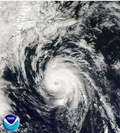
THE CONVECTIVE DEPICTION OF KATIA HAS IMPROVED THIS MORNING AS BOTH
MICROWAVE IMAGERY FROM SSMIS AND CONVENTIONAL VISIBLE SATELLITE
IMAGERY INDICATE THAT AN EYE MAY BE FORMING. BECAUSE OF THE
IMPROVED STRUCTURE...BOTH TAFB AND SAB DVORAK CLASSIFICATIONS CAME
IN AT A 4.0...OR 65 KT...AS DID A 1053Z CIMSS AMSU INTENSITY
ESTIMATE. THUS KATIA HAS REGAINED HURRICANE STATUS.
THE HURRICANE IS MOVING TOWARD THE WEST-NORTHWEST AT ABOUT 12
KT...AS IT IS BEING ADVECTED AROUND THE SOUTHWEST PERIPHERY OF A
DEEP-LAYER RIDGE. KATIA SHOULD MOVE TOWARD THE WEST-NORTHWEST OR
NORTHWEST FOR THE NEXT FEW DAYS AT A SLIGHTLY SLOWER RATE OF SPEED.
ALL OF THE RELIABLE GUIDANCE...WITH THE EXCEPTION OF THE UKMET WHICH
HAS A MUCH MORE EQUATORWARD SOLUTION DUE TO A SHORT-WAVE TROUGH OFF
OF THE U.S. EAST COAST LIFTING OUT TO THE NORTHEAST MORE QUICKLY...
IS IN EXCELLENT AGREEMENT. THE TRACK FORECAST IS VERY SIMILAR TO
THE PREVIOUS ADVISORY AND THE CONSENSUS OF THE GLOBAL AND HURRICANE
MODELS LESS THE UKMET MODEL.
DESPITE BECOMING A HURRICANE AGAIN...KATIA FACES A RELATIVELY
HOSTILE ENVIRONMENT WITH SOUTHWEST VERTICAL SHEAR OF 15-20 KT
SUGGESTED FOR THE NEXT DAY OR TWO. BEYOND 48 HOURS...THE SHEAR
FROM THE GLOBAL MODELS IS ANTICIPATED TO DECREASE...BUT THE
THERMODYNAMICS MAY NOT BE IDEAL WITH LOW HUMIDITIES AND A MORE
STABLE ENVIRONMENT ANTICIPATED. SOME OF THE UPPER-LEVEL
TEMPERATURE INCREASES ANALYZED IN THE SHIPS/LGEM STATISTICAL
MODELS...HOWEVER...MAY BE SPURIOUS...AS THE STRONGER VORTEX FROM
THE GFS MAY BE THE CAUSE OF THESE VALUES RATHER THAN THE
ENVIRONMENT. THUS THE SHIPS/LGEM GUIDANCE MAY BE TOO LOW AT DAYS
THREE TO FIVE. THE INTENSITY PREDICTION IS SLIGHTLY LOWER THAN A
SHIPS/LGEM/HWRF BLEND BUT HIGHER THAN THE PREVIOUS ADVISORY DURING
THE NEXT TWO DAYS.
FORECAST POSITIONS AND MAX WINDS
INIT 02/1500Z 17.5N 52.4W 65 KT 75 MPH
12H 03/0000Z 18.6N 53.8W 65 KT 75 MPH
24H 03/1200Z 19.6N 55.2W 70 KT 80 MPH
36H 04/0000Z 20.6N 56.4W 75 KT 85 MPH
48H 04/1200Z 21.7N 57.9W 80 KT 90 MPH
72H 05/1200Z 24.0N 61.0W 90 KT 105 MPH
96H 06/1200Z 26.0N 64.0W 95 KT 110 MPH
120H 07/1200Z 27.0N 67.0W 100 KT 115 MPH
$$
FORECASTER LANDSEA/STEWART
TCMAT2
HURRICANE KATIA FORECAST/ADVISORY NUMBER 18
NWS NATIONAL HURRICANE CENTER MIAMI FL AL122011
1500 UTC FRI SEP 02 2011
THERE ARE NO COASTAL WATCHES OR WARNINGS IN EFFECT.
HURRICANE CENTER LOCATED NEAR 17.5N 52.4W AT 02/1500Z
POSITION ACCURATE WITHIN 15 NM
PRESENT MOVEMENT TOWARD THE WEST-NORTHWEST OR 300 DEGREES AT 12 KT
ESTIMATED MINIMUM CENTRAL PRESSURE 991 MB
MAX SUSTAINED WINDS 65 KT WITH GUSTS TO 80 KT.
64 KT....... 30NE 0SE 0SW 0NW.
50 KT....... 80NE 50SE 40SW 60NW.
34 KT.......135NE 105SE 60SW 120NW.
12 FT SEAS..270NE 90SE 90SW 180NW.
WINDS AND SEAS VARY GREATLY IN EACH QUADRANT. RADII IN NAUTICAL
MILES ARE THE LARGEST RADII EXPECTED ANYWHERE IN THAT QUADRANT.
REPEAT...CENTER LOCATED NEAR 17.5N 52.4W AT 02/1500Z
AT 02/1200Z CENTER WAS LOCATED NEAR 17.4N 52.0W
FORECAST VALID 03/0000Z 18.6N 53.8W
MAX WIND 65 KT...GUSTS 80 KT.
64 KT... 30NE 0SE 0SW 0NW.
50 KT... 80NE 50SE 40SW 60NW.
34 KT...135NE 105SE 60SW 120NW.
FORECAST VALID 03/1200Z 19.6N 55.2W
MAX WIND 70 KT...GUSTS 85 KT.
64 KT... 40NE 30SE 0SW 0NW.
50 KT... 80NE 60SE 40SW 60NW.
34 KT...135NE 105SE 75SW 120NW.
FORECAST VALID 04/0000Z 20.6N 56.4W
MAX WIND 75 KT...GUSTS 90 KT.
64 KT... 40NE 30SE 20SW 30NW.
50 KT... 80NE 60SE 40SW 60NW.
34 KT...135NE 105SE 75SW 120NW.
FORECAST VALID 04/1200Z 21.7N 57.9W
MAX WIND 80 KT...GUSTS 100 KT.
50 KT... 80NE 60SE 50SW 60NW.
34 KT...135NE 105SE 90SW 120NW.
FORECAST VALID 05/1200Z 24.0N 61.0W
MAX WIND 90 KT...GUSTS 110 KT.
50 KT... 80NE 70SE 60SW 70NW.
34 KT...135NE 120SE 105SW 120NW.
EXTENDED OUTLOOK. NOTE...ERRORS FOR TRACK HAVE AVERAGED NEAR 175 NM
ON DAY 4 AND 225 NM ON DAY 5...AND FOR INTENSITY NEAR 20 KT EACH DAY
OUTLOOK VALID 06/1200Z 26.0N 64.0W
MAX WIND 95 KT...GUSTS 115 KT.
OUTLOOK VALID 07/1200Z 27.0N 67.0W
MAX WIND 100 KT...GUSTS 120 KT.
REQUEST FOR 3 HOURLY SHIP REPORTS WITHIN 300 MILES OF 17.5N 52.4W
NEXT ADVISORY AT 02/2100Z
$$
FORECASTER LANDSEA/STEWART
HURRICANE KATIA DISCUSSION NUMBER 18
NWS NATIONAL HURRICANE CENTER MIAMI FL AL122011
1100 AM AST FRI SEP 02 2011
THE CONVECTIVE DEPICTION OF KATIA HAS IMPROVED THIS MORNING AS BOTH
MICROWAVE IMAGERY FROM SSMIS AND CONVENTIONAL VISIBLE SATELLITE
IMAGERY INDICATE THAT AN EYE MAY BE FORMING. BECAUSE OF THE
IMPROVED STRUCTURE...BOTH TAFB AND SAB DVORAK CLASSIFICATIONS CAME
IN AT A 4.0...OR 65 KT...AS DID A 1053Z CIMSS AMSU INTENSITY
ESTIMATE. THUS KATIA HAS REGAINED HURRICANE STATUS.
THE HURRICANE IS MOVING TOWARD THE WEST-NORTHWEST AT ABOUT 12
KT...AS IT IS BEING ADVECTED AROUND THE SOUTHWEST PERIPHERY OF A
DEEP-LAYER RIDGE. KATIA SHOULD MOVE TOWARD THE WEST-NORTHWEST OR
NORTHWEST FOR THE NEXT FEW DAYS AT A SLIGHTLY SLOWER RATE OF SPEED.
ALL OF THE RELIABLE GUIDANCE...WITH THE EXCEPTION OF THE UKMET WHICH
HAS A MUCH MORE EQUATORWARD SOLUTION DUE TO A SHORT-WAVE TROUGH OFF
OF THE U.S. EAST COAST LIFTING OUT TO THE NORTHEAST MORE QUICKLY...
IS IN EXCELLENT AGREEMENT. THE TRACK FORECAST IS VERY SIMILAR TO
THE PREVIOUS ADVISORY AND THE CONSENSUS OF THE GLOBAL AND HURRICANE
MODELS LESS THE UKMET MODEL.
DESPITE BECOMING A HURRICANE AGAIN...KATIA FACES A RELATIVELY
HOSTILE ENVIRONMENT WITH SOUTHWEST VERTICAL SHEAR OF 15-20 KT
SUGGESTED FOR THE NEXT DAY OR TWO. BEYOND 48 HOURS...THE SHEAR
FROM THE GLOBAL MODELS IS ANTICIPATED TO DECREASE...BUT THE
THERMODYNAMICS MAY NOT BE IDEAL WITH LOW HUMIDITIES AND A MORE
STABLE ENVIRONMENT ANTICIPATED. SOME OF THE UPPER-LEVEL
TEMPERATURE INCREASES ANALYZED IN THE SHIPS/LGEM STATISTICAL
MODELS...HOWEVER...MAY BE SPURIOUS...AS THE STRONGER VORTEX FROM
THE GFS MAY BE THE CAUSE OF THESE VALUES RATHER THAN THE
ENVIRONMENT. THUS THE SHIPS/LGEM GUIDANCE MAY BE TOO LOW AT DAYS
THREE TO FIVE. THE INTENSITY PREDICTION IS SLIGHTLY LOWER THAN A
SHIPS/LGEM/HWRF BLEND BUT HIGHER THAN THE PREVIOUS ADVISORY DURING
THE NEXT TWO DAYS.
FORECAST POSITIONS AND MAX WINDS
INIT 02/1500Z 17.5N 52.4W 65 KT 75 MPH
12H 03/0000Z 18.6N 53.8W 65 KT 75 MPH
24H 03/1200Z 19.6N 55.2W 70 KT 80 MPH
36H 04/0000Z 20.6N 56.4W 75 KT 85 MPH
48H 04/1200Z 21.7N 57.9W 80 KT 90 MPH
72H 05/1200Z 24.0N 61.0W 90 KT 105 MPH
96H 06/1200Z 26.0N 64.0W 95 KT 110 MPH
120H 07/1200Z 27.0N 67.0W 100 KT 115 MPH
$$
FORECASTER LANDSEA/STEWART
0 likes
Visit the Caribbean-Central America Weather Thread where you can find at first post web cams,radars
and observations from Caribbean basin members Click Here
and observations from Caribbean basin members Click Here
-
cycloneye
- Admin
- Posts: 149381
- Age: 69
- Joined: Thu Oct 10, 2002 10:54 am
- Location: San Juan, Puerto Rico
Re: ATL: KATIA - Hurricane - Discussion
HURRICANE KATIA FORECAST/ADVISORY NUMBER 18
NWS NATIONAL HURRICANE CENTER MIAMI FL AL122011
1500 UTC FRI SEP 02 2011
THERE ARE NO COASTAL WATCHES OR WARNINGS IN EFFECT.
HURRICANE CENTER LOCATED NEAR 17.5N 52.4W AT 02/1500Z
POSITION ACCURATE WITHIN 15 NM
NWS NATIONAL HURRICANE CENTER MIAMI FL AL122011
1500 UTC FRI SEP 02 2011
THERE ARE NO COASTAL WATCHES OR WARNINGS IN EFFECT.
HURRICANE CENTER LOCATED NEAR 17.5N 52.4W AT 02/1500Z
POSITION ACCURATE WITHIN 15 NM
0 likes
Visit the Caribbean-Central America Weather Thread where you can find at first post web cams,radars
and observations from Caribbean basin members Click Here
and observations from Caribbean basin members Click Here
-
Blown Away

- S2K Supporter

- Posts: 10253
- Joined: Wed May 26, 2004 6:17 am
ATL: KATIA - Advisories
From the 11am Disco:
The words of the day are:
"Equatorward"
"Spurious"
Never seen those words used! Lol
The words of the day are:
"Equatorward"
"Spurious"
Never seen those words used! Lol
0 likes
Hurricane Eye Experience: David 79, Irene 99, Frances 04, Jeanne 04, Wilma 05… Hurricane Brush Experience: Andrew 92, Erin 95, Floyd 99, Matthew 16, Irma 17, Ian 22, Nicole 22…
-
Maritimer71
- S2K Supporter
- Posts: 41
- Joined: Sun Aug 23, 2009 6:07 am
- Location: Nova Scotia - Canada
-
cycloneye
- Admin
- Posts: 149381
- Age: 69
- Joined: Thu Oct 10, 2002 10:54 am
- Location: San Juan, Puerto Rico
Re: ATL: KATIA - Hurricane - Discussion
More bending to the left at 11 AM track.

Saved image.
Saved image.
0 likes
Visit the Caribbean-Central America Weather Thread where you can find at first post web cams,radars
and observations from Caribbean basin members Click Here
and observations from Caribbean basin members Click Here
-
terrapintransit

- Category 1

- Posts: 275
- Age: 51
- Joined: Tue Sep 04, 2007 8:08 pm
- Location: Williamsport, Pa
-
SouthFLTropics

- Category 5

- Posts: 4258
- Age: 50
- Joined: Thu Aug 14, 2003 8:04 am
- Location: Port St. Lucie, Florida
Re: ATL: KATIA - Hurricane - Discussion
I wonder if the Ukie is onto something here??? Based on the mimic imagery above it seems like it will continue to miss the forecast points to the South and West and it also looks like the existing trough off of the Mid to Northeast Atlantic is pulling out quickly. Things that make you go hmmm... 
SFT
SFT
0 likes
Fourth Generation Florida Native
Personal Storm History: David 79, Andrew 92, Erin 95, Floyd 99, Irene 99, Frances 04, Jeanne 04, Wilma 05, Matthew 16, Irma 17, Ian 22, Nicole 22, Milton 24
Personal Storm History: David 79, Andrew 92, Erin 95, Floyd 99, Irene 99, Frances 04, Jeanne 04, Wilma 05, Matthew 16, Irma 17, Ian 22, Nicole 22, Milton 24


Re: ATL: KATIA - Hurricane - Discussion
SouthFLTropics wrote:I wonder if the Ukie is onto something here??? Based on the mimic imagery above it seems like it will continue to miss the forecast points to the South and West and it also looks like the existing trough off of the Mid to Northeast Atlantic is pulling out quickly. Things that make you go hmmm...
SFT
Sometimes a model just sees things others don't and happens to be right. Not saying this at all with regards to the UKMET, but it has been adamant about that westward bend.
0 likes

Re: ATL: KATIA - Hurricane - Discussion
I fly from Toronto to St Maarten on Sunday, get in at 2:45 or so PM
Hope Katia is far enough away :p
And thanks to this forum I've learnt more about hurricanes in the past week than I had my whole life :p
Hope Katia is far enough away :p
And thanks to this forum I've learnt more about hurricanes in the past week than I had my whole life :p
0 likes
-
AdamFirst

- S2K Supporter
- Posts: 2490
- Age: 36
- Joined: Thu Aug 14, 2008 10:54 am
- Location: Port Saint Lucie, FL
They may divert your flight away from the storm but it looks like Katia is not a threat to the islands. You should be okay. 
0 likes
Dolphins Marlins Canes Golden Panthers HEAT
Andrew 1992 - Irene 1999 - Frances 2004 - Jeanne 2004 - Wilma 2005 - Fay 2008 - Isaac 2012 - Matthew 2016 - Irma 2017 - Dorian 2019 - Ian 2022 - Nicole 2022 - Milton 2024
Andrew 1992 - Irene 1999 - Frances 2004 - Jeanne 2004 - Wilma 2005 - Fay 2008 - Isaac 2012 - Matthew 2016 - Irma 2017 - Dorian 2019 - Ian 2022 - Nicole 2022 - Milton 2024
Re: ATL: KATIA - Hurricane - Discussion
I don't care if it takes longer to get there, I just want to leave already :p
How far in advance do they usually issue TS/Hurricane watches/warnings?
How far in advance do they usually issue TS/Hurricane watches/warnings?
0 likes
-
otowntiger
- Category 5
- Posts: 1932
- Joined: Tue Aug 31, 2004 7:06 pm
Re: ATL: KATIA - Models
terrapintransit wrote:I suppose there may be hope in the GFS little bend north...
[img]http://icons-ecast.wunderground.com/data/images/at201112_model.gif[ /img]
But what you are missing is that in another day or two from that location the storm will make a hard right turn based on the synoptics that are forecast at that time. This models plot is misleading if you make assumptions based on where they ended, but they don't end there. THere aren't any models forecasting this storm to continue heading west from that point. Just my amatuer observation. Personal Forecast Disclaimer:
The posts in this forum are NOT official forecast and should not be used as such. They are just the opinion of the poster and may or may not be backed by sound meteorological data. They are NOT endorsed by any professional institution or storm2k.org. For official information, please refer to the NHC and NWS products
Last edited by RL3AO on Fri Sep 02, 2011 10:57 am, edited 1 time in total.
Reason: Edit out quoted image
Reason: Edit out quoted image
0 likes
-
AdamFirst
- S2K Supporter
- Posts: 2490
- Age: 36
- Joined: Thu Aug 14, 2008 10:54 am
- Location: Port Saint Lucie, FL
Those models are showing a quite unrealistic bend to the north. Tropical storms dont turn on a dime. The fact of the matter is that the models have trended progressively west, including the recurve-trough happy GFS. No reason for it to stop now.
0 likes
Dolphins Marlins Canes Golden Panthers HEAT
Andrew 1992 - Irene 1999 - Frances 2004 - Jeanne 2004 - Wilma 2005 - Fay 2008 - Isaac 2012 - Matthew 2016 - Irma 2017 - Dorian 2019 - Ian 2022 - Nicole 2022 - Milton 2024
Andrew 1992 - Irene 1999 - Frances 2004 - Jeanne 2004 - Wilma 2005 - Fay 2008 - Isaac 2012 - Matthew 2016 - Irma 2017 - Dorian 2019 - Ian 2022 - Nicole 2022 - Milton 2024

Re: ATL: KATIA - Hurricane - Discussion
This change in forecast track is bothersome. I'm not sure what else to say, except that I'm worried that Katia could still go absolutely anywhere--Gulf, East coast, Canada, etc. And that is extremely worrisome.
I'm on JB's side now. No fish.
[Disclaimer: This is an opinion. I am no meteorologist. Refer to the NHC for official information.]
I'm on JB's side now. No fish.
[Disclaimer: This is an opinion. I am no meteorologist. Refer to the NHC for official information.]
0 likes
-
AdamFirst
- S2K Supporter
- Posts: 2490
- Age: 36
- Joined: Thu Aug 14, 2008 10:54 am
- Location: Port Saint Lucie, FL
Re: ATL: KATIA - Models
12z GFS is rolling.


24hr
24hr
0 likes
Dolphins Marlins Canes Golden Panthers HEAT
Andrew 1992 - Irene 1999 - Frances 2004 - Jeanne 2004 - Wilma 2005 - Fay 2008 - Isaac 2012 - Matthew 2016 - Irma 2017 - Dorian 2019 - Ian 2022 - Nicole 2022 - Milton 2024
Andrew 1992 - Irene 1999 - Frances 2004 - Jeanne 2004 - Wilma 2005 - Fay 2008 - Isaac 2012 - Matthew 2016 - Irma 2017 - Dorian 2019 - Ian 2022 - Nicole 2022 - Milton 2024
-
HurricaneWarning92
- Category 2

- Posts: 520
- Joined: Sat Jul 23, 2011 4:33 pm
- Location: Pembroke Pines, S. Florida (Lat: 26.00N, Lon: 80.22W)
who knows, maybe the UKMET is being the most accurate, and all the others are a bit off...
0 likes
The posts in this forum are NOT official forecast and should not be used as such. They are just the opinion of the poster and may or may not be backed by sound meteorological data. They are NOT endorsed by any professional institution or storm2k.org. For official information, please refer to the NHC and NWS products.
Who is online
Users browsing this forum: No registered users and 23 guests