ATL: BRET - Remnants - Discussion
Moderator: S2k Moderators
-
Rgv20

- S2K Supporter

- Posts: 2466
- Age: 39
- Joined: Wed Jan 05, 2011 5:42 pm
- Location: Edinburg/McAllen Tx
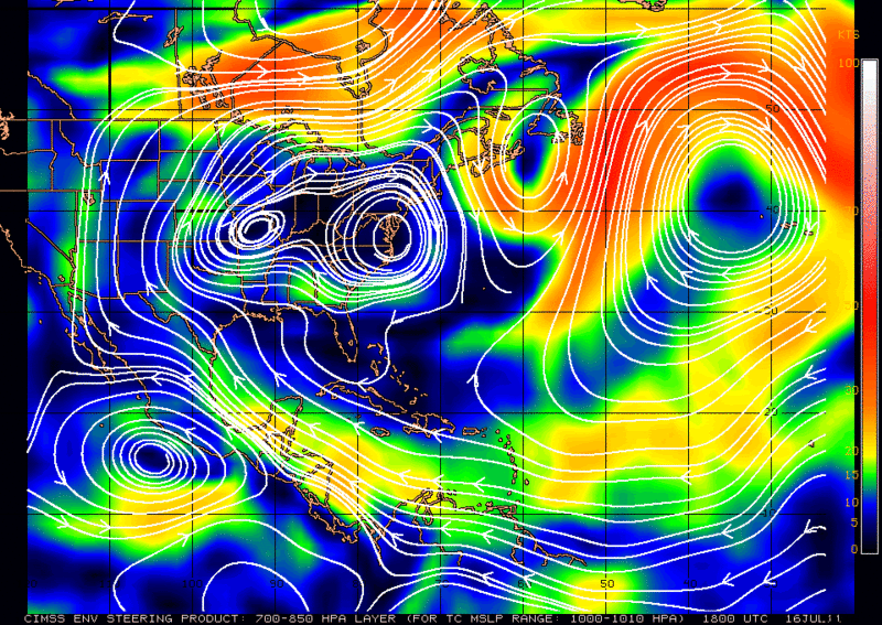
18z Steering Layer for our invest. Very weak steering noted on this analysis.
0 likes
The following post is NOT an official forecast and should not be used as such. It is just the opinion of the poster and may or may not be backed by sound meteorological data. It is NOT endorsed by any professional institution including storm2k.org For Official Information please refer to the NHC and NWS products.
-
CYCLONE MIKE
- Category 5

- Posts: 2183
- Joined: Tue Aug 31, 2004 6:04 pm
- Location: Gonzales, LA
Re: ATL: INVEST 98L - Discussion
Going off some other upper air forecast charts looks like the big high over the central US will build east and block this from moving north anytime soon. Will be interesting to see how long this invest gets trapped and pushed south before getting kicked west across florida into the gulf. Will also be of note to see how much it is able to organize in the next day or two while it is slowly meandering around. Looks like it could have a Katrina type track. Not strength of course, just track.
0 likes


-
MGC

- S2K Supporter
- Posts: 5940
- Joined: Sun Mar 23, 2003 9:05 pm
- Location: Pass Christian MS, or what is left.
Re: ATL: INVEST 98L - Discussion
Convection looks to have diminished this afternoon. Wondering if the low over the Fla panhandle will have an impact on 98L......MGC
0 likes
-
Aric Dunn
- Category 5
- Posts: 21238
- Age: 43
- Joined: Sun Sep 19, 2004 9:58 pm
- Location: Ready for the Chase.
- Contact:
convection should begin to develop over the next few hours.
0 likes
Note: If I make a post that is brief. Please refer back to previous posts for the analysis or reasoning. I do not re-write/qoute what my initial post said each time.
If there is nothing before... then just ask
Space & Atmospheric Physicist, Embry-Riddle Aeronautical University,
I believe the sky is falling...
If there is nothing before... then just ask
Space & Atmospheric Physicist, Embry-Riddle Aeronautical University,
I believe the sky is falling...
-
Dean4Storms
- S2K Supporter
- Posts: 6358
- Age: 63
- Joined: Sun Aug 31, 2003 1:01 pm
- Location: Miramar Bch. FL
-
Dean4Storms
- S2K Supporter
- Posts: 6358
- Age: 63
- Joined: Sun Aug 31, 2003 1:01 pm
- Location: Miramar Bch. FL
-
wxman57

- Moderator-Pro Met

- Posts: 23172
- Age: 68
- Joined: Sat Jun 21, 2003 8:06 pm
- Location: Houston, TX (southwest)
Re: ATL: INVEST 98L - Discussion
12Z Euro takes a weak low NE and out to sea in a few days. GFS appears to do the same, though it's hard to see on the GFS. Canadian just dissipates a weak low east of FL. Something to keep an eye on, but probably not a big U.S. threat as far as any wind.
0 likes

Looks like the sort of system that would have a pretty good chance of developing once it starts to lift out NE...its a classic early season type development (since we are really still in the first part of the season).
0 likes
Personal Forecast Disclaimer:
The posts in this forum are NOT official forecast and should not be used as such. They are just the opinion of the poster and may or may not be backed by sound meteorological data. They are NOT endorsed by any professional institution or storm2k.org. For official information, please refer to the NHC and NWS products
The posts in this forum are NOT official forecast and should not be used as such. They are just the opinion of the poster and may or may not be backed by sound meteorological data. They are NOT endorsed by any professional institution or storm2k.org. For official information, please refer to the NHC and NWS products

Re: ATL: INVEST 98L - Discussion
Looks like it was tagged since it has a warm core and PV is in the mid-levels.
However, no deep convection to push circulation to the surface and push out shear.
Too much UL vorticity to spin this up to a full tropical system for at least the next 24 hrs.
Need to see if deep convection fires around sunrise at DMAX. There is enough shear to fire up a deep MCS.
Maybe this will become a hybrid.
0 likes
Possibly Gcane, thats the sort of system I'd expect, I've tend to find that when these systems go NNE/NE they tend to have their best shot at developing.
0 likes
Personal Forecast Disclaimer:
The posts in this forum are NOT official forecast and should not be used as such. They are just the opinion of the poster and may or may not be backed by sound meteorological data. They are NOT endorsed by any professional institution or storm2k.org. For official information, please refer to the NHC and NWS products
The posts in this forum are NOT official forecast and should not be used as such. They are just the opinion of the poster and may or may not be backed by sound meteorological data. They are NOT endorsed by any professional institution or storm2k.org. For official information, please refer to the NHC and NWS products

Re: ATL: INVEST 98L- Models
If 98L develops, it could become Bret. I know storms in the past have formed off the east coast of Florida and even Carolinas and hit Texas. Hurricane #3 1934 and Hurricane #2 1940.
Let's hope it moves into Texas and gives us rain we need.
Let's hope it moves into Texas and gives us rain we need.
0 likes
-
Aric Dunn
- Category 5
- Posts: 21238
- Age: 43
- Joined: Sun Sep 19, 2004 9:58 pm
- Location: Ready for the Chase.
- Contact:
Radar is looking quite a bit more impressive. out of melbourne..
0 likes
Note: If I make a post that is brief. Please refer back to previous posts for the analysis or reasoning. I do not re-write/qoute what my initial post said each time.
If there is nothing before... then just ask
Space & Atmospheric Physicist, Embry-Riddle Aeronautical University,
I believe the sky is falling...
If there is nothing before... then just ask
Space & Atmospheric Physicist, Embry-Riddle Aeronautical University,
I believe the sky is falling...
-
SouthDadeFish

- Professional-Met

- Posts: 2835
- Joined: Thu Sep 23, 2010 2:54 pm
- Location: Miami, FL
- Contact:
Re:
Aric Dunn wrote:Radar is looking quite a bit more impressive. out of melbourne..
I completely agree. Maybe up to 30% at 8 pm. Cyclonic turning is quite evident on radar.
0 likes
-
Aric Dunn
- Category 5
- Posts: 21238
- Age: 43
- Joined: Sun Sep 19, 2004 9:58 pm
- Location: Ready for the Chase.
- Contact:
Re: Re:
SouthDadeFish wrote:Aric Dunn wrote:Radar is looking quite a bit more impressive. out of melbourne..
I completely agree. Maybe up to 30% at 8 pm. Cyclonic turning is quite evident on radar.
yeah as the mid level circ has dropped south over the weak LOW analyzed earlier convection begin to fire as was expected. this type of convection is what is needed to work the MLC down to the surface. Also the farther it drops south the better chance it has... as the shear lessens quite a bit.
0 likes
Note: If I make a post that is brief. Please refer back to previous posts for the analysis or reasoning. I do not re-write/qoute what my initial post said each time.
If there is nothing before... then just ask
Space & Atmospheric Physicist, Embry-Riddle Aeronautical University,
I believe the sky is falling...
If there is nothing before... then just ask
Space & Atmospheric Physicist, Embry-Riddle Aeronautical University,
I believe the sky is falling...
-
northjaxpro

- S2K Supporter
- Posts: 8900
- Joined: Mon Sep 27, 2010 11:21 am
- Location: Jacksonville, FL
Convection is beginning to build on the south and east of the circulation. Also, the Low has actually drifted more to the southeast for the duration of the afternoon. Observing Melbourne long range radar, the Low now appears positioned approximately 100-125 miles east of Saint Augustine. The Low is still drifting S-SE slowly at this time.
0 likes
NEVER, EVER SAY NEVER in the tropics and weather in general, and most importantly, with life itself!!
________________________________________________________________________________________
Fay 2008 Beryl 2012 Debby 2012 Colin 2016 Hermine 2016 Julia 2016 Matthew 2016 Irma 2017 Dorian 2019
________________________________________________________________________________________
Fay 2008 Beryl 2012 Debby 2012 Colin 2016 Hermine 2016 Julia 2016 Matthew 2016 Irma 2017 Dorian 2019
-
Rainband
Re: ATL: INVEST 98L - Discussion
can i have some tartar sauce with my fish:)wxman57 wrote:12Z Euro takes a weak low NE and out to sea in a few days. GFS appears to do the same, though it's hard to see on the GFS. Canadian just dissipates a weak low east of FL. Something to keep an eye on, but probably not a big U.S. threat as far as any wind.
0 likes
-
Aric Dunn
- Category 5
- Posts: 21238
- Age: 43
- Joined: Sun Sep 19, 2004 9:58 pm
- Location: Ready for the Chase.
- Contact:
Re:
northjaxpro wrote:Convection is beginning to build on the south and east of the circulation. Also, the Low has actually drifted more to the southeast for the duration of the afternoon. Observing Melbourne long range radar, the Low now appears positioned approximately 100-125 miles east of Saint Augustine. The Low is still drifting S-SE slowly at this time.
well its a bit farther south. straight east of New Symyrna Beach ... about 50 miles south of St augustine. but none the less yeah its still slowly dropping SSE

0 likes
Note: If I make a post that is brief. Please refer back to previous posts for the analysis or reasoning. I do not re-write/qoute what my initial post said each time.
If there is nothing before... then just ask
Space & Atmospheric Physicist, Embry-Riddle Aeronautical University,
I believe the sky is falling...
If there is nothing before... then just ask
Space & Atmospheric Physicist, Embry-Riddle Aeronautical University,
I believe the sky is falling...
Who is online
Users browsing this forum: No registered users and 10 guests