ATL: IRENE - Models

Moderator: S2k Moderators

Message
Author
User avatar
KWT
Category 5
Category 5
Posts: 31415
Joined: Tue Aug 17, 2004 11:02 am
Location: UK!!!

Re: ATL: IRENE - Models

#2381 Postby KWT » Sun Aug 21, 2011 11:48 am

Ivanhater wrote:GFS, EURO and Canadian now keep this to the east of Florida and show more of a problem for Georgia and the Carolinas...Florida would be on the weaker side as opposed if this moved into the eastern Gulf.


Its worse for Florida as well bar maybe the far west...

Think about it, rather thena65-75kts system coming in and going up the spine, you've mgot a 110-120kts hurrricane...the winds on the western side will probably be the same as what it would have if it took the other route.

I've said time and time again this will NOT recurve, the upper pattern is a little different to most storms, more like what it was with say Hugo, though probably not quite such a NW bend.

This is my worst case showing here, a system without signficant land interaction that has the synoptics aloft to prevent a total recurve...

When you get that, you tend to get Hazel/Hugo type strength systems into the east coast...BIG worry.
0 likes   
Personal Forecast Disclaimer:
The posts in this forum are NOT official forecast and should not be used as such. They are just the opinion of the poster and may or may not be backed by sound meteorological data. They are NOT endorsed by any professional institution or storm2k.org. For official information, please refer to the NHC and NWS products

Scorpion

Re: ATL: IRENE - Models

#2382 Postby Scorpion » Sun Aug 21, 2011 11:50 am

KWT wrote:
Ivanhater wrote:GFS, EURO and Canadian now keep this to the east of Florida and show more of a problem for Georgia and the Carolinas...Florida would be on the weaker side as opposed if this moved into the eastern Gulf.


Its worse for Florida as well bar maybe the far west...

Think about it, rather thena65-75kts system coming in and going up the spine, you've mgot a 110-120kts hurrricane...the winds on the western side will probably be the same as what it would have if it took the other route.

I've said time and time again this will NOT recurve, the upper pattern is a little different to most storms, more like what it was with say Hugo, though probably not quite such a NW bend.

This is my worst case showing here, a system without signficant land interaction that has the synoptics aloft to prevent a total recurve...

When you get that, you tend to get Hazel/Hugo type strength systems into the east coast...BIG worry.


Agreed, especially if the core stays just off shore so it can still strengthen but yet create hurricane conditions on the Florida East Coast.
0 likes   

User avatar
linkerweather
Professional-Met
Professional-Met
Posts: 261
Joined: Sat Jul 23, 2005 5:59 am
Location: tampa bay area

Re: ATL: IRENE - Models

#2383 Postby linkerweather » Sun Aug 21, 2011 11:53 am

Remember, this is just one run of a model that has been "fairly" consistent in developing a SE US hurricane for the last week or so. But, solutions have ranged from Texas to the Carolinas, with most through the spine of Florida. I don't foresee a recurve as others have posted, but not certain where it begins that NW move. The GFS ensembles with each run have generally been west of the actual GFS output.
0 likes   

HurricaneWarning92
Category 2
Category 2
Posts: 520
Joined: Sat Jul 23, 2011 4:33 pm
Location: Pembroke Pines, S. Florida (Lat: 26.00N, Lon: 80.22W)

#2384 Postby HurricaneWarning92 » Sun Aug 21, 2011 11:53 am

Looking at the latest GFS run, a tad delay of the turn to the north around Andros Island, and it would come ashore South Florida. There is still many ifs up in the air.
0 likes   
The posts in this forum are NOT official forecast and should not be used as such. They are just the opinion of the poster and may or may not be backed by sound meteorological data. They are NOT endorsed by any professional institution or storm2k.org. For official information, please refer to the NHC and NWS products.

WilmingtonSandbar
S2K Supporter
S2K Supporter
Posts: 505
Joined: Sun Aug 29, 2010 12:11 pm
Location: Southport, NC

Re: ATL: IRENE - Models

#2385 Postby WilmingtonSandbar » Sun Aug 21, 2011 11:56 am

Is this the first run that ended without a landfall in the runs time frame? If it did make landfall in the run, where at? I missed it.
0 likes   
Diana X2 (look it up), Bertha, Fran, Bonnie, Floyd, Dennis, Charley, Ophelia, Ernesto, Irene, Matthew, And Florence

WeatherEmperor
S2K Supporter
S2K Supporter
Posts: 4806
Age: 41
Joined: Thu Sep 04, 2003 2:54 pm
Location: South Florida

Re: ATL: IRENE - Models

#2386 Postby WeatherEmperor » Sun Aug 21, 2011 11:56 am

HurricaneWarning92 wrote:Looking at the latest GFS run, a tad delay of the turn to the north around Andros Island, and it would come ashore South Florida. There is still many ifs up in the air.


That is exactly what I am worried about. It looks like it will come close enough to the east coast of FL that any deviation to the west by as little as 15-20 miles could make a difference as to how hard we could potentially get hit. I am sure you agree with me on this, it should come close enough to cause concern in south florida.
0 likes   

User avatar
KWT
Category 5
Category 5
Posts: 31415
Joined: Tue Aug 17, 2004 11:02 am
Location: UK!!!

#2387 Postby KWT » Sun Aug 21, 2011 11:56 am

Yeah its still a really tight call, wouldn't feel at all happy if I lived in Florida yet.

Still the track forecasted by the GFS is a prime track type for a major hurricane...a further west track and you'll probably get a much weaker storm due to land interaction.

12z ECM is going to be SO interesting tonight!
0 likes   
Personal Forecast Disclaimer:
The posts in this forum are NOT official forecast and should not be used as such. They are just the opinion of the poster and may or may not be backed by sound meteorological data. They are NOT endorsed by any professional institution or storm2k.org. For official information, please refer to the NHC and NWS products

User avatar
SeminoleWind
Category 1
Category 1
Posts: 359
Age: 50
Joined: Wed Jun 02, 2010 8:37 pm
Location: Lake County Florida

Re:

#2388 Postby SeminoleWind » Sun Aug 21, 2011 11:57 am

HurricaneWarning92 wrote:Looking at the latest GFS run, a tad delay of the turn to the north around Andros Island, and it would come ashore South Florida. There is still many ifs up in the air.

just a 4-8 delay in that forecast turn could mean hurricane conditions for all of east central Florida also
0 likes   
This post is NOT an official forecast and should not be used as such. It is just the opinion of the poster and may or may not be backed by sound meteorological data. It is NOT endorsed by any professional institution including storm2k.org For Official Information please refer to the NHC and NWS products.

User avatar
gatorcane
S2K Supporter
S2K Supporter
Posts: 23692
Age: 47
Joined: Sun Mar 13, 2005 3:54 pm
Location: Boca Raton, FL

#2389 Postby gatorcane » Sun Aug 21, 2011 11:57 am

Hi folks checking in....yes there is a trend east with the models..but just yesterday the ensembles were in the Central GOM. This one is definitely worrisome. The angle of approach to South FL is going to make this very difficult perhaps..storms like Floyd, David, Cleo, come to mind. Bahamas under the gun. Lots of loooong days and nights on storm2k ahead. :eek:

Almighty Euro is next...I got to think it takes it east of Florida also but as a very powerful system....how much east is going to be important.
Last edited by gatorcane on Sun Aug 21, 2011 11:58 am, edited 2 times in total.
0 likes   

psyclone
S2K Supporter
S2K Supporter
Posts: 4769
Joined: Wed Aug 24, 2005 9:04 pm
Location: palm harbor fl

Re: Re:

#2390 Postby psyclone » Sun Aug 21, 2011 11:57 am

Bocadude85 wrote:
psyclone wrote:we certainly have a trend in florida's favor at this point. let's see if it persists.


lol I am not very comfortable with a hurricane passing a 100 miles to my east considering the track error in that time frame is greater then 100 miles. I have a flight out of Miami thursday night so I am hoping this misses us to the east.

you shouldn't be comfortable with a cane passing 100 miles to your east. but you should be heartened to some extent when multiple runs keep taking it a bit more east each time. that is a slow trend with ample time to yield a good result for florida should it persist. that was my only observation...holy smokes i gotta watch it around here...people spaz out!
0 likes   

User avatar
LowndesCoFire
Tropical Storm
Tropical Storm
Posts: 137
Age: 43
Joined: Tue Aug 19, 2008 5:03 pm
Location: Valdosta, GA

Re: ATL: IRENE - Models

#2391 Postby LowndesCoFire » Sun Aug 21, 2011 11:57 am

Irene in the Hebert Box at present, right?
0 likes   
The above post is personal opinion only and should be taken as such. Please refer to official forecasts from professional sources such as your local NWS office or the NHC.

WeatherEmperor
S2K Supporter
S2K Supporter
Posts: 4806
Age: 41
Joined: Thu Sep 04, 2003 2:54 pm
Location: South Florida

Re:

#2392 Postby WeatherEmperor » Sun Aug 21, 2011 11:58 am

Aric Dunn wrote:12z nogaps is nearly identical.. except instead of nnw turn like the gfs at day 5 it stays straight north..

https://www.fnmoc.navy.mil/wxmap_cgi/cg ... t=Tropical


Yes Aric. If you look carefully, the Nogaps brings the center of Irene a little bit closer to the east coast of FL compared to the GFS. It looks like maybe 25 miles or so closer to FL compared to GFS. Either way, it looks to get very close to FL.
0 likes   

User avatar
thundercam96
Tropical Storm
Tropical Storm
Posts: 129
Joined: Thu Aug 18, 2011 3:01 pm
Location: Boston, MA

Re: ATL: IRENE - Models

#2393 Postby thundercam96 » Sun Aug 21, 2011 11:59 am

There have been dynamical models that develop this in to a high end major hurricane. The Track is Now East of flordia just 24 hours after it was projected to be in the gulf. If it ends up not recurving and heading for east coast of Flordia, ,What will be the Strength?
Last edited by thundercam96 on Sun Aug 21, 2011 12:00 pm, edited 1 time in total.
0 likes   
Fay '08 / Mathew 16'

Personal Forecast Disclaimer: I am not a certified meteorologist, therefore, what is posted on this forum under my header should not be treated as an official forecast. Please refer to the NWS/NHC products for forecast information.

psyclone
S2K Supporter
S2K Supporter
Posts: 4769
Joined: Wed Aug 24, 2005 9:04 pm
Location: palm harbor fl

Re: ATL: IRENE - Models

#2394 Postby psyclone » Sun Aug 21, 2011 11:59 am

linkerweather wrote:Remember, this is just one run of a model that has been "fairly" consistent in developing a SE US hurricane for the last week or so. But, solutions have ranged from Texas to the Carolinas, with most through the spine of Florida. I don't foresee a recurve as others have posted, but not certain where it begins that NW move. The GFS ensembles with each run have generally been west of the actual GFS output.

Josh you have lots of people in the bay area depending on terrific bay news 9 team! eat your wheaties!
0 likes   

User avatar
Ivanhater
Storm2k Moderator
Storm2k Moderator
Posts: 11162
Age: 38
Joined: Fri Jul 01, 2005 8:25 am
Location: Pensacola

Re: ATL: IRENE - Models

#2395 Postby Ivanhater » Sun Aug 21, 2011 12:00 pm

12z Canadian is even further east..good distance off Florida

Image
0 likes   
Michael

maxintensity
Tropical Storm
Tropical Storm
Posts: 165
Joined: Tue Aug 02, 2011 9:54 pm

Re: ATL: IRENE - Models

#2396 Postby maxintensity » Sun Aug 21, 2011 12:00 pm

delete
Last edited by maxintensity on Sun Aug 21, 2011 12:01 pm, edited 1 time in total.
0 likes   

tolakram
Admin
Admin
Posts: 20012
Age: 62
Joined: Sun Aug 27, 2006 8:23 pm
Location: Florence, KY (name is Mark)

Re: ATL: IRENE - Models

#2397 Postby tolakram » Sun Aug 21, 2011 12:00 pm

LowndesCoFire wrote:Irene in the Hebert Box at present, right?


Yes, but it doesn't mean what you think it does. :) Lot of storms pass through the Herbert box and never hit Florida, but most storms that hit Florida pass through the Herbert box.
0 likes   
M a r k
- - - - -
Join us in chat: Storm2K Chatroom Invite. Android and IOS apps also available.

The posts in this forum are NOT official forecasts and should not be used as such. Posts are NOT endorsed by any professional institution or STORM2K.org. For official information and forecasts, please refer to NHC and NWS products.

User avatar
SeminoleWind
Category 1
Category 1
Posts: 359
Age: 50
Joined: Wed Jun 02, 2010 8:37 pm
Location: Lake County Florida

#2398 Postby SeminoleWind » Sun Aug 21, 2011 12:01 pm

i suspect IF the NHC moves the cone at all it will be a modest shift to the right but i wouldn't expect much.
0 likes   
This post is NOT an official forecast and should not be used as such. It is just the opinion of the poster and may or may not be backed by sound meteorological data. It is NOT endorsed by any professional institution including storm2k.org For Official Information please refer to the NHC and NWS products.

User avatar
Ivanhater
Storm2k Moderator
Storm2k Moderator
Posts: 11162
Age: 38
Joined: Fri Jul 01, 2005 8:25 am
Location: Pensacola

Re: ATL: IRENE - Models

#2399 Postby Ivanhater » Sun Aug 21, 2011 12:02 pm

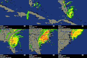
Misses the entire east coast through 144 hours...maybe brushing the outer banks

Image
0 likes   
Michael

User avatar
linkerweather
Professional-Met
Professional-Met
Posts: 261
Joined: Sat Jul 23, 2005 5:59 am
Location: tampa bay area

Re: ATL: IRENE - Models

#2400 Postby linkerweather » Sun Aug 21, 2011 12:03 pm

psyclone wrote:
linkerweather wrote:Remember, this is just one run of a model that has been "fairly" consistent in developing a SE US hurricane for the last week or so. But, solutions have ranged from Texas to the Carolinas, with most through the spine of Florida. I don't foresee a recurve as others have posted, but not certain where it begins that NW move. The GFS ensembles with each run have generally been west of the actual GFS output.

Josh you have lots of people in the bay area depending on terrific bay news 9 team! eat your wheaties!


Thanks...we try to keep the hype machine of local media in check. Wheaties? Maybe Lucky charms!!!
:D
0 likes   


Return to “2011”

Who is online

Users browsing this forum: No registered users and 16 guests