915
URNT15 KNHC 290052
AF307 0404A DON HDOB 19 20110729
004200 2309N 09313W 8429 01568 0091 +176 +137 356012 013 007 001 00
004230 2308N 09314W 8428 01569 0090 +176 +137 349012 013 007 001 03
004300 2306N 09314W 8426 01570 0090 +175 +140 344009 011 /// /// 03
004330 2306N 09313W 8430 01568 0090 +176 +139 343007 007 006 002 03
004400 2306N 09311W 8429 01568 0090 +179 +135 338008 008 010 001 00
004430 2307N 09309W 8429 01568 0090 +180 +133 328007 008 006 001 00
004500 2307N 09307W 8432 01567 0091 +178 +136 331008 008 008 002 00
004530 2307N 09305W 8428 01570 0090 +177 +139 331008 009 012 001 00
004600 2307N 09304W 8430 01567 0091 +180 +137 325008 008 010 001 00
004630 2307N 09302W 8431 01567 0090 +180 +138 327009 009 011 001 00
004700 2307N 09300W 8429 01568 0090 +178 +141 325009 009 010 001 00
004730 2308N 09258W 8432 01567 0093 +175 +148 325008 009 010 002 00
004800 2308N 09256W 8432 01565 0092 +170 +150 323008 008 013 002 00
004830 2308N 09254W 8428 01570 0093 +171 +150 321009 009 014 002 00
004900 2308N 09253W 8429 01568 0094 +172 +142 323009 010 018 002 00
004930 2308N 09251W 8429 01569 0095 +170 +152 317009 009 014 003 00
005000 2308N 09249W 8429 01568 0095 +170 +153 315010 010 014 002 00
005030 2308N 09247W 8430 01568 0095 +170 +141 312009 010 015 003 00
005100 2309N 09245W 8430 01567 0095 +168 +148 308009 010 018 002 00
005130 2309N 09243W 8430 01567 0095 +165 +147 300009 010 017 002 00
$$
;
ATL: DON - Remnant - Discussion
Moderator: S2k Moderators


Re: ATL: DON - Tropical Storm - Discussion
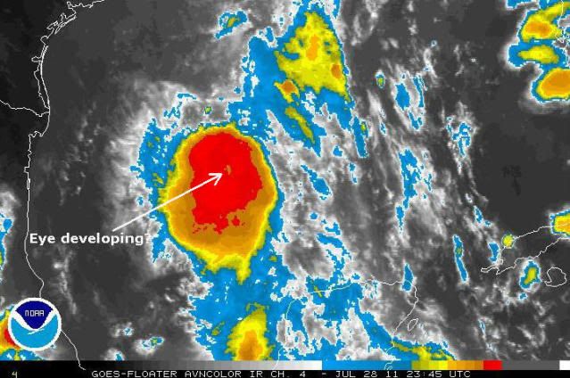
I don't know what it takes for an eye to develop but that sure looks like it could be
the embryo of one for sure.
the embryo of one for sure.
0 likes

-
vbhoutex

- Storm2k Executive

- Posts: 29143
- Age: 74
- Joined: Wed Oct 09, 2002 11:31 pm
- Location: Cypress, TX
- Contact:
Re:
lebron23 wrote:Appears that NHC will bump track a bit further south tonight.
What makes you say this? Such a bold statement as this needs some support.
0 likes
Skywarn, C.E.R.T.
Please click below to donate to STORM2K to help with the expenses of keeping the site going:

Please click below to donate to STORM2K to help with the expenses of keeping the site going:

Re: ATL: DON - Tropical Storm - Discussion
hipshot wrote:I don't know what it takes for an eye to develop but that sure looks like it could be
the embryo of one for sure.
That might just be a convective anomaly within the burst...though to be fair, it is quite near the center. I think Don is still too disorganized and immature to be thinking about visible eye formation at this time.
0 likes


Re: Re:
vbhoutex wrote:lebron23 wrote:Appears that NHC will bump track a bit further south tonight.
What makes you say this? Such a bold statement as this needs some support.
Take a look at the 00z models. There all south of the last projected path. The TVCN line that they closely follow is a 30-40 miles below corpus.
0 likes
-
plasticup
Re: ATL: DON - Tropical Storm - Discussion
ozonepete wrote:
That patch disappears in the next frame.
0 likes
-
Tireman4

- S2K Supporter

- Posts: 5903
- Age: 60
- Joined: Fri Jun 30, 2006 1:08 pm
- Location: Humble, Texas
- Contact:
Re:
SouthDadeFish wrote:This is a weird storm. A 996 mb "blob." A big ball of convection without any strong bands. It's an annular tropical stormjust kidding of course.
Ok SDF, that made me laugh.. thanks....a 996 MB "blob"...
0 likes


Re: ATL: DON - Tropical Storm - Discussion
As long as Don keeps moving and doesn't stall it shouldn't be too bad. Even a Cat 1 hurricane usually only results in a few downed power lines as long as it blows through in just a couple hours.
0 likes
-
Tireman4
- S2K Supporter
- Posts: 5903
- Age: 60
- Joined: Fri Jun 30, 2006 1:08 pm
- Location: Humble, Texas
- Contact:
Re: Re:
[That's what I've been forecasting...once it got to Thursday evening and 25N....
Started to feel like I was in the woods all alone...naked. LOL [/quote]
LOL AFM, I never doubted you for a minute. You are the BEST when it comes to the tropics, and I don't know how we would survive around here at Storm2k without you. Thanks so much for all you do.[/quote]
Well....I wouldn't go that far guys...I have my fair share of busts that's for certain. But thanks for not remembering them.[/quote]
I agree with them AFM. You have had your busts, but you and Wxman 57 stuck to your guns about it getting its act together once it got into the Gulf. You and he are to be commended.
Started to feel like I was in the woods all alone...naked. LOL
LOL AFM, I never doubted you for a minute. You are the BEST when it comes to the tropics, and I don't know how we would survive around here at Storm2k without you. Thanks so much for all you do.[/quote]
Well....I wouldn't go that far guys...I have my fair share of busts that's for certain. But thanks for not remembering them.[/quote]
I agree with them AFM. You have had your busts, but you and Wxman 57 stuck to your guns about it getting its act together once it got into the Gulf. You and he are to be commended.
0 likes
-
Dave

- Retired Staff

- Posts: 13442
- Age: 75
- Joined: Tue Aug 01, 2006 3:57 pm
- Location: Milan Indiana
- Contact:
185
URNT15 KNHC 290101
AF307 0404A DON HDOB 20 20110729
005200 2309N 09241W 8429 01567 0096 +163 +152 295009 010 016 003 00
005230 2309N 09240W 8432 01564 0095 +162 +151 292010 011 020 003 00
005300 2309N 09238W 8430 01563 0092 +169 +136 285012 012 022 004 00
005330 2309N 09236W 8429 01568 0095 +169 +141 277012 013 015 006 00
005400 2309N 09234W 8433 01564 0095 +166 +144 269012 012 019 004 00
005430 2309N 09232W 8430 01570 0100 +166 +134 262010 011 022 003 00
005500 2309N 09230W 8433 01569 0101 +169 +138 256011 012 021 004 00
005530 2309N 09228W 8426 01575 0101 +169 +136 256013 014 024 007 00
005600 2309N 09226W 8434 01568 0107 +157 +144 255015 015 021 010 00
005630 2309N 09226W 8434 01568 0104 +165 +136 251014 014 024 007 00
005700 2309N 09223W 8433 01569 0110 +154 +143 255015 016 031 009 00
005730 2310N 09221W 8425 01575 0109 +158 +145 274013 015 026 007 00
005800 2310N 09219W 8429 01568 0104 +159 +154 255010 011 024 007 00
005830 2310N 09217W 8429 01573 0104 +162 +151 263012 014 023 007 00
005900 2311N 09215W 8430 01571 0104 +163 +149 271014 015 021 008 00
005930 2311N 09213W 8429 01573 0107 +160 +149 262014 014 026 010 00
010000 2312N 09211W 8429 01574 0110 +154 //// 252014 015 028 008 01
010030 2312N 09209W 8429 01575 0110 +153 //// 243014 015 030 007 01
010100 2312N 09208W 8427 01575 0115 +146 //// 267015 016 026 011 01
010130 2312N 09206W 8429 01573 0111 +151 //// 265014 015 029 013 01
$$
;
0 likes

Re: ATL: DON - Tropical Storm - Discussion
vbhoutex wrote:Javlin wrote:Well if you go look at the WV loop you can see high cloud movement NNW at the TX/LA border being created in part I think by the ULL in Mexico/part of TX.Then we may have a strengthing storm more poleward movement possible coming from that you got to start wondering if Mid/N TX come back into play?just wondering.
here: http://www.atmos.washington.edu/~ovens/ ... nhanced+12
The ULL to the West and the ULL to the East are definitely both working on Don right now, at least as far as steering is concerned. I'm not sure what that steering is going to do, but my instinct tells me that you may be correct in your assessment. That coupled with the obvious strengthening going on troubles me a little for our area as the media in this area is pretty much telling us to write Don off except for a little rain. I will definitely be following him late into the night after seeing that loop and the obvious strengthening going on. When is recon expected in next?(I haven't been following it today)
Honestly guys...are we sure we're not wish-casting? Or is this something that can really play out? Mets in my area (Beaumont) have just about 99% written off this storm except for the increase in moisture (which doesnt seem to be all that aswell). My question is, is it still POSSIBLE (especially looking at the new models that shifted southward, again) ...and should our mets not have written this off just yet? Thanks in adavance!!
0 likes
-
Tireman4
- S2K Supporter
- Posts: 5903
- Age: 60
- Joined: Fri Jun 30, 2006 1:08 pm
- Location: Humble, Texas
- Contact:
Re: Re:
lebron23 wrote:vbhoutex wrote:lebron23 wrote:Appears that NHC will bump track a bit further south tonight.
What makes you say this? Such a bold statement as this needs some support.
Take a look at the 00z models. There all south of the last projected path. The TVCN line that they closely follow is a 30-40 miles below corpus.
Remember Lebron...these are the same models that had Don dead for almost two days. I think it will be interesting as to what will happen the next 24 hours.
The posts in this forum are NOT official forecast and should not be used as such. They are just the opinion of the poster and may or may not be backed by sound meteorological data. They are NOT endorsed by any professional institution or storm2k.org. For official information, please refer to the NHC and NWS products
0 likes
-
Tireman4
- S2K Supporter
- Posts: 5903
- Age: 60
- Joined: Fri Jun 30, 2006 1:08 pm
- Location: Humble, Texas
- Contact:
Re: ATL: DON - Tropical Storm - Discussion
HGX's take on things as they stand now:
AS OF NOW...TROPICAL STORM DON WILL HAVE A MINIMAL IMPACT ON THE
REGION. WITH THAT BEING SAID...THE THREAT FOR FAR OUTER RAIN BANDS
(WITH EMBEDDED STORMS) IS MODERATE. THUS...00Z TAF PACKAGE REFLECTS
CONTINUED PHILOSOPHY OF EARLY MORNING WARM AIR ADVECTION SHOWERS
RIDING IN FROM THE SOUTH...WITH PERIODS OF SCATTERED RAIN AND ISOLATED
THUNDER FROM LATE MORNING THROUGH MID-AFTERNOON. DON`S TRACK HAS
IT REMAINING FAR ENOUGH SOUTH AS TO NOT PREVAIL AFTERNOON CONVECTION...
RATHER VC WITH TEMPOS TO COMMUNICATE THE MODERATE PROBABILITY/CONFIDENCE
OF ANY MID-LATE MORNING THROUGH MID-AFTERNOON FAR OUTER BANDS. IF
DON DOES TRACK MORE WEST-SOUTHWEST THAN NORTH...THAN FUTURE PACKAGES
WILL TAPER OFF THE THUNDER THREAT AND/OR END CONVECTION EARLIER IN
THE DAY. PERIODS OF INTERMITTENT MVFR DECKS WILL OCCUR DURING PERIODS
OF PASSING RAIN/STORMS. DUE TO TIGHTER NORTHEASTERN PRESSURE GRADIENT
DOWN THE COAST TOWARDS DON...TOMORROW`S WINDS WILL BACK TO THE
EAST AND BECOME MODERATE IN MAGNITUDE. 31
http://forecast.weather.gov/product.php ... glossary=1
0 likes
-
Dave
- Retired Staff
- Posts: 13442
- Age: 75
- Joined: Tue Aug 01, 2006 3:57 pm
- Location: Milan Indiana
- Contact:
942
URNT15 KNHC 290112
AF307 0404A DON HDOB 21 20110729
010200 2312N 09204W 8428 01573 0111 +151 //// 261013 014 029 007 01
010230 2312N 09202W 8433 01569 0111 +149 //// 263015 016 026 008 01
010300 2312N 09200W 8428 01573 0104 +159 //// 251013 015 029 008 01
010330 2313N 09158W 8430 01569 0097 +172 +153 235011 013 024 006 00
010400 2313N 09156W 8430 01570 0097 +170 +149 238014 014 024 006 00
010430 2313N 09154W 8431 01569 0098 +171 +139 236015 016 024 005 00
010500 2313N 09152W 8430 01570 0096 +174 +137 236015 016 022 006 00
010530 2313N 09150W 8430 01571 0101 +170 +133 233017 018 022 006 00
010600 2313N 09148W 8430 01570 0099 +168 +144 238016 016 022 005 00
010630 2313N 09147W 8428 01574 0099 +170 +149 235013 014 021 004 00
010700 2314N 09145W 8429 01571 0099 +169 +152 231015 015 017 002 00
010730 2314N 09143W 8433 01568 0100 +166 +160 227017 017 017 000 03
010800 2314N 09141W 8430 01571 0100 +166 +164 224017 018 015 001 00
010830 2314N 09139W 8431 01570 0101 +165 +157 226016 017 011 001 00
010900 2314N 09137W 8427 01575 0101 +164 +162 225016 018 015 000 00
010930 2314N 09135W 8434 01569 0104 +165 +158 228015 016 015 002 00
011000 2314N 09133W 8428 01576 0101 +173 +120 221017 019 019 000 03
011030 2315N 09131W 8428 01576 0099 +178 +107 228019 019 019 000 00
011100 2315N 09129W 8432 01573 0101 +176 +123 225020 020 017 000 00
011130 2315N 09128W 8430 01574 0101 +174 +135 220020 020 013 001 00
$$
;
0 likes

Who is online
Users browsing this forum: No registered users and 17 guests