ATL: DON - Remnant - Discussion

Moderator: S2k Moderators

Message
Author
ozonepete
Professional-Met
Professional-Met
Posts: 4743
Joined: Mon Sep 07, 2009 3:23 pm
Location: From Ozone Park, NYC / Now in Brooklyn, NY

Re: ATL: DON - Tropical Storm - Discussion

#3061 Postby ozonepete » Thu Jul 28, 2011 8:18 pm

plasticup wrote:
ozonepete wrote:Image

That patch disappears in the next frame.


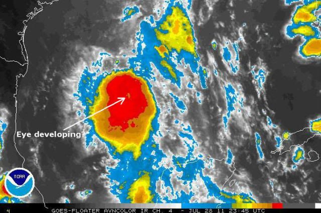
They characteristically "blink" on and off at first. I didn't want to say anything more than it's a possibility, anyway. Just love to try and guess how the visual clues work. :D
Last edited by ozonepete on Thu Jul 28, 2011 8:20 pm, edited 1 time in total.
0 likes   

User avatar
South Texas Storms
Professional-Met
Professional-Met
Posts: 4224
Joined: Thu Jun 24, 2010 12:28 am
Location: Houston, TX

Re: ATL: DON - Tropical Storm - Discussion

#3062 Postby South Texas Storms » Thu Jul 28, 2011 8:19 pm

Based on the latest trend in the models, I'm starting to lose hope for much needed rainfall from SA to Austin to Houston. :cry:

I really hope they shift northward with tonight's 0z runs.
0 likes   

ozonepete
Professional-Met
Professional-Met
Posts: 4743
Joined: Mon Sep 07, 2009 3:23 pm
Location: From Ozone Park, NYC / Now in Brooklyn, NY

Re: ATL: DON - Tropical Storm - Discussion

#3063 Postby ozonepete » Thu Jul 28, 2011 8:21 pm

South Texas Storms wrote:Based on the latest trend in the models, I'm starting to lose hope for much needed rainfall from SA to Austin to Houston. :cry:

I really hope they shift northward with tonight's 0z runs.


Hang on. There's a (relatively) long way to go. Although the stronger it gets, the more south it'll go.
0 likes   

Javlin
Category 5
Category 5
Posts: 1619
Age: 64
Joined: Fri Jul 09, 2004 7:58 pm
Location: ms gulf coast

Re: ATL: DON - Tropical Storm - Discussion

#3064 Postby Javlin » Thu Jul 28, 2011 8:22 pm

djmikey wrote:
vbhoutex wrote:
Javlin wrote:Well if you go look at the WV loop you can see high cloud movement NNW at the TX/LA border being created in part I think by the ULL in Mexico/part of TX.Then we may have a strengthing storm more poleward movement possible coming from that you got to start wondering if Mid/N TX come back into play?just wondering.

here: http://www.atmos.washington.edu/~ovens/ ... nhanced+12

The ULL to the West and the ULL to the East are definitely both working on Don right now, at least as far as steering is concerned. I'm not sure what that steering is going to do, but my instinct tells me that you may be correct in your assessment. That coupled with the obvious strengthening going on troubles me a little for our area as the media in this area is pretty much telling us to write Don off except for a little rain. I will definitely be following him late into the night after seeing that loop and the obvious strengthening going on. When is recon expected in next?(I haven't been following it today)

Honestly guys...are we sure we're not wish-casting? Or is this something that can really play out? Mets in my area (Beaumont) have just about 99% written off this storm except for the increase in moisture (which doesnt seem to be all that aswell). My question is, is it still POSSIBLE (especially looking at the new models that shifted southward, again) ...and should our mets not have written this off just yet? Thanks in adavance!!


I think just looking at the upper level winds out there in the short 6-8 hr a more N'erly component is possible not the end all.I saw either Chantal or Claudette go due N and swung like a slingshot around an ULL into TX.Then you go look at this;
http://cimss.ssec.wisc.edu/tropic/real- ... /main.html Hmnnnn.....I might be way off;just observing
0 likes   

User avatar
Dave
Retired Staff
Retired Staff
Posts: 13442
Age: 74
Joined: Tue Aug 01, 2006 3:57 pm
Location: Milan Indiana
Contact:

#3065 Postby Dave » Thu Jul 28, 2011 8:24 pm

214
URNT15 KNHC 290121
AF307 0404A DON HDOB 22 20110729
011200 2315N 09126W 8429 01575 0102 +172 +131 216020 020 016 000 00
011230 2315N 09124W 8428 01576 0102 +174 +127 216019 020 016 000 00
011300 2315N 09122W 8430 01574 0101 +176 +126 214019 020 020 000 00
011330 2315N 09120W 8429 01576 0099 +183 +108 213020 020 021 001 00
011400 2316N 09118W 8427 01579 0100 +180 +128 209020 021 022 000 00
011430 2316N 09116W 8429 01576 0101 +180 +108 207019 020 021 001 00
011500 2316N 09114W 8428 01578 0101 +179 +104 202017 018 017 002 00
011530 2316N 09112W 8430 01575 0102 +180 +113 194018 019 016 001 00
011600 2316N 09111W 8426 01580 0102 +179 +115 194020 020 018 000 00
011630 2316N 09109W 8433 01575 0101 +179 +114 191019 020 013 000 00
011700 2316N 09107W 8428 01581 0104 +176 +127 191019 019 011 001 03
011730 2316N 09105W 8430 01578 0105 +175 +137 192019 019 010 002 00
011800 2317N 09103W 8433 01576 0105 +178 +130 192019 019 010 001 00
011830 2317N 09101W 8429 01581 0108 +173 +138 188019 019 013 000 00
011900 2317N 09100W 8428 01584 0110 +170 +146 184018 018 011 000 00
011930 2317N 09058W 8428 01584 0110 +170 +141 182017 017 008 001 00
012000 2317N 09056W 8429 01584 0111 +172 +134 182017 017 007 001 00
012030 2317N 09054W 8429 01585 0111 +176 +115 183019 019 008 001 00
012100 2317N 09052W 8432 01582 0111 +176 +109 181019 019 008 001 00
012130 2318N 09051W 8429 01585 0109 +180 +116 183018 019 006 001 03
$$
;
0 likes   

User avatar
gatorcane
S2K Supporter
S2K Supporter
Posts: 23691
Age: 47
Joined: Sun Mar 13, 2005 3:54 pm
Location: Boca Raton, FL

#3066 Postby gatorcane » Thu Jul 28, 2011 8:24 pm

The posts in this forum are NOT official forecast and should not be used as such. They are just the opinion of the poster and may or may not be backed by sound meteorological data. They are NOT endorsed by any professional institution or storm2k.org. For official information, please refer to the NHC and NWS products

18Z NAM below at 24 hours. Notice the pocket of moderate ENE windshear hugging the Western Gulf of Mexico. That combined with dry air that will get pulled down from Texas is the reason why the NHC (and myself) feel that this cannot become a full blown hurricane. The shear should also keep the deepest convection SW of the center so most of that should impact extreme S. Texas and Northern Mexico.

I don't expect we will see a deep blob of red near landfall like we are seeing now -- once it feels the impacts of the dry air:

Image
Last edited by gatorcane on Thu Jul 28, 2011 8:26 pm, edited 4 times in total.
0 likes   

User avatar
HURAKAN
Professional-Met
Professional-Met
Posts: 46086
Age: 38
Joined: Thu May 20, 2004 4:34 pm
Location: Key West, FL
Contact:

Re: ATL: DON - Recon

#3067 Postby HURAKAN » Thu Jul 28, 2011 8:24 pm

Image
0 likes   

User avatar
South Texas Storms
Professional-Met
Professional-Met
Posts: 4224
Joined: Thu Jun 24, 2010 12:28 am
Location: Houston, TX

Re: ATL: DON - Tropical Storm - Discussion

#3068 Postby South Texas Storms » Thu Jul 28, 2011 8:24 pm

ozonepete wrote:
South Texas Storms wrote:Based on the latest trend in the models, I'm starting to lose hope for much needed rainfall from SA to Austin to Houston. :cry:

I really hope they shift northward with tonight's 0z runs.


Hang on. There's a (relatively) long way to go. Although the stronger it gets, the more south it'll go.


Yeah that scares me too as it looks to be strengthening pretty rapidly tonight...
0 likes   

lebron23
Category 1
Category 1
Posts: 389
Age: 32
Joined: Sat May 24, 2008 11:58 am
Contact:

Re: ATL: DON - Models

#3069 Postby lebron23 » Thu Jul 28, 2011 8:24 pm

Lets hope GFDL is right..... :cry:
0 likes   

User avatar
South Texas Storms
Professional-Met
Professional-Met
Posts: 4224
Joined: Thu Jun 24, 2010 12:28 am
Location: Houston, TX

Re: ATL: DON - Models

#3070 Postby South Texas Storms » Thu Jul 28, 2011 8:26 pm

lebron23 wrote:Lets hope GFDL is right..... :cry:


Yeah seriously... :cry:
0 likes   

User avatar
Meteorcane
Category 2
Category 2
Posts: 559
Joined: Thu Jul 21, 2011 6:49 am
Location: North Platte Nebraska

#3071 Postby Meteorcane » Thu Jul 28, 2011 8:26 pm

Any chance NHC gets a little risky and say trims the warning to Port O'Connor and possibly adds the southern watch area?
0 likes   

User avatar
HurricaneBrain
S2K Supporter
S2K Supporter
Posts: 520
Joined: Thu Jun 30, 2011 2:07 pm

#3072 Postby HurricaneBrain » Thu Jul 28, 2011 8:27 pm

Final landfall - Corpus Christi and south.
0 likes   

lebron23
Category 1
Category 1
Posts: 389
Age: 32
Joined: Sat May 24, 2008 11:58 am
Contact:

Re:

#3073 Postby lebron23 » Thu Jul 28, 2011 8:28 pm

HurricaneBrain wrote:Final landfall - Corpus Christi and south.


I'd say thats not set yet. I could see Don going as far north as rockport
0 likes   

User avatar
HurricaneBrain
S2K Supporter
S2K Supporter
Posts: 520
Joined: Thu Jun 30, 2011 2:07 pm

#3074 Postby HurricaneBrain » Thu Jul 28, 2011 8:29 pm

Corpus and down should be concerned.
0 likes   

User avatar
gatorcane
S2K Supporter
S2K Supporter
Posts: 23691
Age: 47
Joined: Sun Mar 13, 2005 3:54 pm
Location: Boca Raton, FL

#3075 Postby gatorcane » Thu Jul 28, 2011 8:31 pm

Looks like the 00Z model guidance has shifted southward. Given extrapolation from current forward speed of the system and current heading, it seems reasonable. The 12Z ECMWF actually noticeably weakens Don as it approaches extreme southern Texas.

I wouldn't be surprised if the NHC track is nudged southward for the next advisory.

12Z ECMWF:
Image
0 likes   

User avatar
vbhoutex
Storm2k Executive
Storm2k Executive
Posts: 29112
Age: 73
Joined: Wed Oct 09, 2002 11:31 pm
Location: Cypress, TX
Contact:

Re: ATL: DON - Tropical Storm - Discussion

#3076 Postby vbhoutex » Thu Jul 28, 2011 8:33 pm

djmikey wrote:
vbhoutex wrote:
Javlin wrote:Well if you go look at the WV loop you can see high cloud movement NNW at the TX/LA border being created in part I think by the ULL in Mexico/part of TX.Then we may have a strengthing storm more poleward movement possible coming from that you got to start wondering if Mid/N TX come back into play?just wondering.

here: http://www.atmos.washington.edu/~ovens/ ... nhanced+12

The ULL to the West and the ULL to the East are definitely both working on Don right now, at least as far as steering is concerned. I'm not sure what that steering is going to do, but my instinct tells me that you may be correct in your assessment. That coupled with the obvious strengthening going on troubles me a little for our area as the media in this area is pretty much telling us to write Don off except for a little rain. I will definitely be following him late into the night after seeing that loop and the obvious strengthening going on. When is recon expected in next?(I haven't been following it today)

Honestly guys...are we sure we're not wish-casting? Or is this something that can really play out? Mets in my area (Beaumont) have just about 99% written off this storm except for the increase in moisture (which doesnt seem to be all that aswell). My question is, is it still POSSIBLE (especially looking at the new models that shifted southward, again) ...and should our mets not have written this off just yet? Thanks in adavance!!

Javlin and I are in agreement. I am not thinking that Don will head North, but looking at that loop a more Northerly component would not be a surprise, almost like a squeeze play. As far as -removed- is concerned, NO! I've been through enough Hurricanes(Camille, Alicia, Ike) and TS to know better than to wishcast. I call it like I see it and sometimes I eat crow. Speaking of calling it like I see it. Landfall near Rockport unless Don has major strengthening and then he will be closer to Corpus.
Here's the -removed- for you. I hope Don spreads out a lot more and slows down so all of us in Texas get some much needed rain. Do I think that will happen? No, but I can hope. :cheesy:
0 likes   
Skywarn, C.E.R.T.
Please click below to donate to STORM2K to help with the expenses of keeping the site going:
Image

lebron23
Category 1
Category 1
Posts: 389
Age: 32
Joined: Sat May 24, 2008 11:58 am
Contact:

Re:

#3077 Postby lebron23 » Thu Jul 28, 2011 8:33 pm

gatorcane wrote:Looks like the 00Z model guidance has shifted southward. Given SAT imagery extrapolation from current forward speed of the system, it seems reasonable. The 12Z ECMWF actually noticeably weakens Don as it approaches extreme southern Texas.

I wouldn't be surprised if the NHC track is nudged southward for the next advisory.

12Z ECMWF:
Image


I notice future 91L on the 12Z ECMWF. Back on topic............Track will probably be shifted, will likely look a lot like the 5am one this morning.
0 likes   

User avatar
Dave
Retired Staff
Retired Staff
Posts: 13442
Age: 74
Joined: Tue Aug 01, 2006 3:57 pm
Location: Milan Indiana
Contact:

#3078 Postby Dave » Thu Jul 28, 2011 8:34 pm

975
URNT15 KNHC 290131
AF307 0404A DON HDOB 23 20110729
012200 2318N 09049W 8429 01584 0108 +181 +112 186018 018 006 000 00
012230 2318N 09047W 8429 01584 0108 +182 +100 190018 018 009 001 00
012300 2318N 09045W 8431 01581 0107 +182 +102 190017 018 002 001 03
012330 2320N 09045W 8429 01584 0108 +180 +111 184016 017 /// /// 03
012400 2321N 09046W 8434 01579 0108 +180 +118 177015 016 008 000 00
012430 2322N 09047W 8429 01585 0107 +180 +122 174016 017 008 000 00
012500 2323N 09049W 8430 01582 0110 +179 +123 171017 017 009 001 00
012530 2324N 09050W 8429 01585 0111 +175 +115 171017 018 010 002 00
012600 2326N 09051W 8430 01582 0111 +172 +131 167018 020 008 002 00
012630 2327N 09053W 8431 01580 0110 +170 +135 162021 021 009 001 00
012700 2328N 09054W 8429 01582 0109 +175 +130 164022 023 012 000 00
012730 2330N 09056W 8430 01580 0106 +180 +105 173020 021 006 002 00
012800 2331N 09057W 8433 01579 0108 +178 +101 182020 021 010 001 00
012830 2332N 09058W 8427 01582 0107 +180 +096 189021 022 013 000 00
012900 2333N 09100W 8433 01578 0106 +180 +106 187022 022 013 000 00
012930 2335N 09101W 8429 01580 0106 +178 +097 190023 023 012 001 00
013000 2336N 09102W 8429 01580 0106 +179 +106 188022 023 014 000 00
013030 2337N 09104W 8431 01578 0106 +175 +128 184021 022 013 001 00
013100 2339N 09105W 8432 01576 0106 +175 +124 187022 022 011 001 00
013130 2340N 09106W 8429 01580 0104 +178 +120 184023 023 010 001 00
$$
;
0 likes   

djmikey
Tropical Storm
Tropical Storm
Posts: 153
Joined: Tue Jul 20, 2010 6:04 pm
Location: Beaumont, TX

Re: ATL: DON - Tropical Storm - Discussion

#3079 Postby djmikey » Thu Jul 28, 2011 8:36 pm

Thanks guys! Very much appreciated!
0 likes   

CrazyC83
Professional-Met
Professional-Met
Posts: 34002
Joined: Tue Mar 07, 2006 11:57 pm
Location: Deep South, for the first time!

Re:

#3080 Postby CrazyC83 » Thu Jul 28, 2011 8:36 pm

Meteorcane wrote:Any chance NHC gets a little risky and say trims the warning to Port O'Connor and possibly adds the southern watch area?


It would be risky for sure, I would leave a TS Watch up for areas north of there for now. A Hurricane Watch might be warranted, but not sure how high they will set the forecast at. If the forecast is for 55-60 kt, then a Hurricane Watch should be added as well to the TS Warning.
0 likes   


Return to “2011”

Who is online

Users browsing this forum: No registered users and 2 guests