phwxenthusiast wrote::uarrow: here's the recent one i could find

Looks like there's a dry slot to the north of the eyewall.
Moderator: S2k Moderators
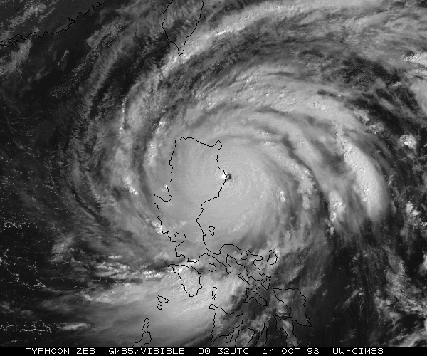
HurricaneBill wrote:Another storm that maintained its eye until landfall was Super Typhoon Zeb in 1998.


euro6208 wrote:HurricaneBill wrote:Another storm that maintained its eye until landfall was Super Typhoon Zeb in 1998.
http://tropic.ssec.wisc.edu/storm_archi ... /ZEB4A.GIF
amazing but scary imagezeb was analyzed to be a rival of super typhoon tip according to this presentation. the video presentation is great so you should watch it.
http://ams.confex.com/ams/26HURR/techpr ... _75465.htm
KWT wrote:big change on the 12z ECM, this time it makes landfall MUCH further north. Not quite as strong by that point obviously but still a system that needs watching.
Comes close enough to the Chinese coast to require close attention.

Ptarmigan wrote:I read that Zeb had a central pressure of 872 millibars or less, which was based on Dvorak. I wonder if any weather stations in the Philippines recorded the central pressure of Zeb at landfall. If so, it would be the most intense on record. If Zeb hit a more populated area like Manila, it would be much worse.


Typhoon Hunter wrote:Just running through the different forecasting agencies and models and their CPAs to Okinawa at this point:
JMA 00z - still looks to track south of Okinawa by about 100km. Core destructive winds would stay offshore but would still give the island marginal typhoon conditions.
JTWC 18z - direct hit in 4 days 110kts gusting to 135kts.
CWB 18z - direct hit in 4 days (no intensity forecast)
HKO 12z - similar to JMA, looks like a harder turn and track south of Okinawa at 110kts (10 min winds)
KMA 00z - looks like direct hit with winds of around 93kts (is KMA wind average 10 mins?)
CMA (China) 00z - passing just offshore to south as a monster with around 130kts sustained (2 min average?). They still expecting it go sub 900hPa again!
ECMWF 12z - more or less direct hit on Okinawa as a slow moving and intensifying monster of a typhoon.
Users browsing this forum: No registered users and 40 guests