
ATL: INVEST 94L - DISCUSSION
Moderator: S2k Moderators
-
tolakram
- Admin

- Posts: 20185
- Age: 62
- Joined: Sun Aug 27, 2006 8:23 pm
- Location: Florence, KY (name is Mark)
Re: ATL: INVEST 94L - DISCUSSION
Looking at the MIMIC-TPW loop, it appears the best circulation is now well west of Jamaica.
0 likes
M a r k
- - - - -
Join us in chat: Storm2K Chatroom Invite. Android and IOS apps also available.
The posts in this forum are NOT official forecasts and should not be used as such. Posts are NOT endorsed by any professional institution or STORM2K.org. For official information and forecasts, please refer to NHC and NWS products.


Re: ATL: INVEST 94L - DISCUSSION
This thing is quite impressive for a June system. Very large gyre now encompassing the western caribbean. A monsoon trough in early-June? Hope this doesn't portend the rest of the season.
http://www.ssd.noaa.gov/goes/flt/t2/flash-rb-s.html
http://www.ssd.noaa.gov/goes/flt/t2/flash-rb-s.html
0 likes
-
cycloneye

- Admin
- Posts: 149426
- Age: 69
- Joined: Thu Oct 10, 2002 10:54 am
- Location: San Juan, Puerto Rico
Re: ATL: INVEST 94L - DISCUSSION
00z Best Track
AL, 94, 2011060600, , BEST, 0, 169N, 801W, 25, 1007, DB
ftp://ftp.tpc.ncep.noaa.gov/atcf/tcweb/ ... 011.invest
AL, 94, 2011060600, , BEST, 0, 169N, 801W, 25, 1007, DB
ftp://ftp.tpc.ncep.noaa.gov/atcf/tcweb/ ... 011.invest
0 likes
Visit the Caribbean-Central America Weather Thread where you can find at first post web cams,radars
and observations from Caribbean basin members Click Here
and observations from Caribbean basin members Click Here
-
MGC

- S2K Supporter

- Posts: 5940
- Joined: Sun Mar 23, 2003 9:05 pm
- Location: Pass Christian MS, or what is left.
Re: ATL: INVEST 94L - DISCUSSION
If the MCL could work it way down to the surface 94L would have a much greater chance of becoming a TC....the current surface circulation has little chance IMO......MGC
0 likes


-
SFLcane

- S2K Supporter
- Posts: 10281
- Age: 48
- Joined: Sat Jun 05, 2010 1:44 pm
- Location: Lake Worth Florida
Re: ATL: INVEST 94L - DISCUSSION
The strong mid/upper level circ is displaced at least 100 nmi east of the LLCC. That is severe decoupling. Perhaps the M/U circ can bore down to the surface, but it isn't likely. My thinking is the 400 mb flow (still nwly at 12Z at Cayman) to turn easterly for about 12 hr or so on Monday afternoon and evening, which would allow for the two circs to become aligned before the mid to upper flow turns back swly north of 20N and shears the system apart with the remnant LLCC moving nnwd just west of FL...which will FINALLY kick in the rainy season.
0 likes
-
Florida1118
Re: ATL: INVEST 94L - DISCUSSION

Convection had really decreased, but to be expected during DMIN. Overall orgainization IMO has increased, and might become a TD tomorrow. We'll have to see what DMAX does for 94L...if it fails again tomorrow IMO it wont make it. But, the tropics are always suprising.
Personal Forecast Disclaimer:
The posts in this forum are NOT official forecast and should not be used as such. They are just the opinion of the poster and may or may not be backed by sound meteorological data. They are NOT endorsed by any professional institution or storm2k.org. For official information, please refer to the NHC and NWS products.
0 likes
-
cycloneye
- Admin
- Posts: 149426
- Age: 69
- Joined: Thu Oct 10, 2002 10:54 am
- Location: San Juan, Puerto Rico
Re: ATL: INVEST 94L - DISCUSSION
The 00z surface analysis shows the low stationary.

Uploaded by imageshack.us
Uploaded by imageshack.us
0 likes
Visit the Caribbean-Central America Weather Thread where you can find at first post web cams,radars
and observations from Caribbean basin members Click Here
and observations from Caribbean basin members Click Here
-
srainhoutx

- S2K Supporter
- Posts: 6919
- Age: 68
- Joined: Sun Jan 14, 2007 11:34 am
- Location: Haywood County, NC
- Contact:
Re: ATL: INVEST 94L - DISCUSSION
Pressures have been slowly falling at buoy 42057, not too terribly far from the surface low. We'll see what tomorrow brings. That said, the development to the W and a nice outflow signature is encouraging in regards to any future development. These monsoonal trough/gyre situations always take a bit of time, IMO.
0 likes
Carla/Alicia/Jerry(In The Eye)/Michelle/Charley/Ivan/Dennis/Katrina/Rita/Wilma/Ike/Harvey
Member: National Weather Association
Wx Infinity Forums
http://wxinfinity.com/index.php
Facebook.com/WeatherInfinity
Twitter @WeatherInfinity
Member: National Weather Association
Wx Infinity Forums
http://wxinfinity.com/index.php
Facebook.com/WeatherInfinity
Twitter @WeatherInfinity
Re: ATL: INVEST 94L - DISCUSSION
If it's developing it should go from the present d-min to another burst like it did yesterday.
0 likes
-
Rgv20

- S2K Supporter
- Posts: 2466
- Age: 39
- Joined: Wed Jan 05, 2011 5:42 pm
- Location: Edinburg/McAllen Tx
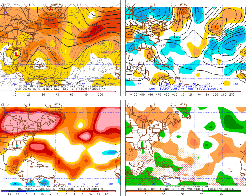
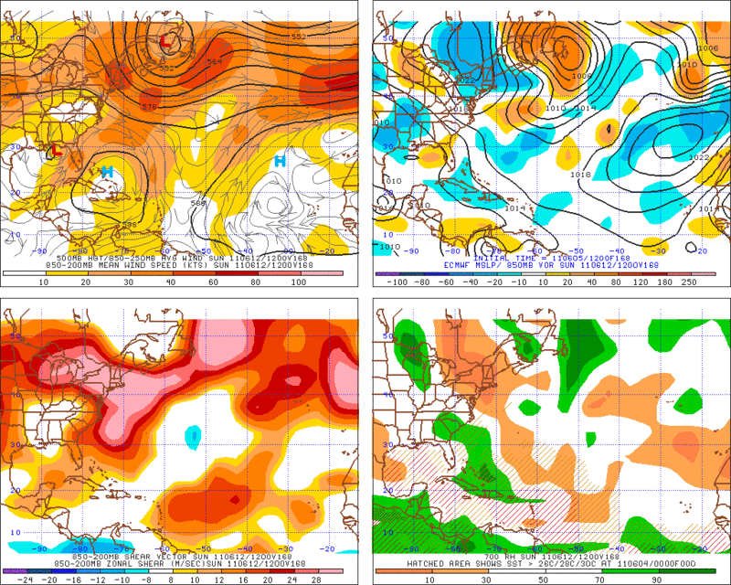
Taking a look at the 12z Euro shear map for the weekend it looks like the central and eastern gulf is not the most favorable environment for a strengthening tropical system and that is good news. Looks like Florida will get some beneficial rains.
0 likes
The following post is NOT an official forecast and should not be used as such. It is just the opinion of the poster and may or may not be backed by sound meteorological data. It is NOT endorsed by any professional institution including storm2k.org For Official Information please refer to the NHC and NWS products.
-
wxman57

- Moderator-Pro Met

- Posts: 23174
- Age: 68
- Joined: Sat Jun 21, 2003 8:06 pm
- Location: Houston, TX (southwest)
Re: ATL: INVEST 94L - DISCUSSION
Just took a look at sfc obs in the region. Winds are down and pressures are slightly up around the disturbance. Convection/convergence remain quite weak. Threat to Gulf may be increasing, though. But if the threat is mostly rain, then that won't be bad.
0 likes
-
SouthDadeFish

- Professional-Met

- Posts: 2835
- Joined: Thu Sep 23, 2010 2:54 pm
- Location: Miami, FL
- Contact:
Re: ATL: INVEST 94L - DISCUSSION
http://www.ssd.noaa.gov/goes/flt/t2/flash-avn.html
there is your refire as if it was listening to you guys......very close to the center with some cold tops....
there is your refire as if it was listening to you guys......very close to the center with some cold tops....
0 likes
Re: ATL: INVEST 94L - MODELS
0z GFS coming out 30hrs....broad low and another one to the east....whats with the GFS sheesh....
http://www.nco.ncep.noaa.gov/pmb/nwprod ... n_030l.gif
http://www.nco.ncep.noaa.gov/pmb/nwprod ... n_030l.gif
0 likes
-
Florida1118
-
SouthDadeFish
- Professional-Met
- Posts: 2835
- Joined: Thu Sep 23, 2010 2:54 pm
- Location: Miami, FL
- Contact:
In my opinion, which is not an official forecast, I feel there is a possibility that we will see a center reformation tonight, as it seemed the LLC was weakening before we lost visible images. The MLC was quite vigorous and the fact that we are seeing a refiring of convection in the same spot is more evidence of this.
0 likes
Re: ATL: INVEST 94L - MODELS
http://www.nco.ncep.noaa.gov/pmb/nwprod ... v_042l.gif
well it initialized right but doesnt have a firm grasp IMO....
http://www.nco.ncep.noaa.gov/pmb/nwprod ... v_000l.gif
well it initialized right but doesnt have a firm grasp IMO....
http://www.nco.ncep.noaa.gov/pmb/nwprod ... v_000l.gif
0 likes
-
SouthDadeFish
- Professional-Met
- Posts: 2835
- Joined: Thu Sep 23, 2010 2:54 pm
- Location: Miami, FL
- Contact:

Who is online
Users browsing this forum: No registered users and 9 guests