
H. 980 mb
I. 9 C / 3039 m
J. 16 C / 3051 m
K. NA / NA
L. OPEN SE
M. C15
Pretty good looking vdm except for the open eyewall.
ATL: IRENE - Remnants - Discussion
Moderator: S2k Moderators
-
SouthFLTropics

- Category 5

- Posts: 4258
- Age: 50
- Joined: Thu Aug 14, 2003 8:04 am
- Location: Port St. Lucie, Florida
Re: ATL: IRENE - Hurricane - Discussion
I was referring to that swath of dry air that looks to be trying to work itself into the core. I guess it's all relative...
SFT
SFT
0 likes
Fourth Generation Florida Native
Personal Storm History: David 79, Andrew 92, Erin 95, Floyd 99, Irene 99, Frances 04, Jeanne 04, Wilma 05, Matthew 16, Irma 17, Ian 22, Nicole 22, Milton 24
Personal Storm History: David 79, Andrew 92, Erin 95, Floyd 99, Irene 99, Frances 04, Jeanne 04, Wilma 05, Matthew 16, Irma 17, Ian 22, Nicole 22, Milton 24
-
CrazyC83
- Professional-Met

- Posts: 34315
- Joined: Tue Mar 07, 2006 11:57 pm
- Location: Deep South, for the first time!
000
URNT15 KNHC 230431
AF303 0709A IRENE HDOB 39 20110823
042100 2011N 06931W 6948 03042 //// +095 //// 084072 078 /// /// 05
042130 2013N 06933W 6984 03029 //// +085 //// 070069 072 /// /// 05
042200 2014N 06935W 6960 03065 //// +092 //// 064065 070 /// /// 05
042230 2015N 06936W 6966 03065 //// +119 //// 069062 063 /// /// 05
042300 2017N 06938W 6969 03070 //// +127 //// 066059 060 /// /// 05
042330 2018N 06939W 6966 03079 //// +128 //// 064058 058 /// /// 05
042400 2019N 06941W 6967 03080 //// +129 //// 064056 057 /// /// 05
042430 2021N 06942W 6966 03087 //// +128 //// 063056 056 /// /// 05
042500 2022N 06944W 6968 03089 //// +115 //// 069058 058 /// /// 05
042530 2022N 06944W 6968 03089 //// +107 //// 070057 058 /// /// 05
042600 2025N 06947W 6965 03106 //// +098 //// 068057 058 /// /// 05
042630 2026N 06948W 6968 03095 //// +101 //// 069056 056 /// /// 05
042700 2027N 06950W 6967 03099 //// +097 //// 070057 059 /// /// 05
042730 2029N 06951W 6966 03106 //// +103 //// 070052 054 /// /// 05
042800 2030N 06953W 6965 03108 //// +094 //// 069054 057 /// /// 05
042830 2031N 06954W 6970 03108 //// +094 //// 067052 054 /// /// 05
042900 2033N 06956W 6968 03113 //// +098 //// 068053 056 /// /// 05
042930 2034N 06957W 6969 03113 //// +099 //// 069055 057 /// /// 05
043000 2035N 06959W 6968 03119 //// +100 //// 067060 061 /// /// 05
043030 2037N 07000W 6970 03123 //// +098 //// 062063 064 /// /// 05
$$
;
0 likes
-
SouthDadeFish

- Professional-Met
- Posts: 2835
- Joined: Thu Sep 23, 2010 2:54 pm
- Location: Miami, FL
- Contact:
Re:
RL3AO wrote:H. 980 mb
I. 9 C / 3039 m
J. 16 C / 3051 m
K. NA / NA
L. OPEN SE
M. C15
Pretty good looking vdm except for the open eyewall.
So apparently the eye shrank 15 nm....
0 likes
-
Dave

- Retired Staff

- Posts: 13442
- Age: 75
- Joined: Tue Aug 01, 2006 3:57 pm
- Location: Milan Indiana
- Contact:
DECODED VDM OB 17
Product: Air Force Vortex Message (URNT12 KNHC)
Transmitted: 23rd day of the month at 04:29Z
Aircraft: Air Force Aircraft (Last 3 digits of the tail number are 303)
Storm Number & Year: 09L in 2011
Storm Name: Irene (flight in the North Atlantic basin)
Mission Number: 7
Observation Number: 17
A. Time of Center Fix: 23rd day of the month at 4:17:30Z
B. Center Fix Coordinates: 20°00'N 69°25'W (20.N 69.4167W)
B. Center Fix Location: 110 miles (176 km) to the NNE (16°) from Santo Domingo, Dominican Republic.
C. Minimum Height at Standard Level: 2,933m (9,623ft) at 700mb
D & E. Estimated (by SFMR or visually) Maximum Surface Wind: Not Available
F. Maximum Flight Level Wind Inbound: From 138° at 83kts (From the SE at ~ 95.5mph)
G. Location of Maximum Flight Level Wind Inbound: 14 nautical miles (16 statute miles) to the NE (50°) of center fix
H. Minimum Sea Level Pressure: 980mb (28.94 inHg)
I. Maximum Flight Level Temp & Pressure Altitude Outside Eye: 9°C (48°F) at a pressure alt. of 3,039m (9,970ft)
J. Maximum Flight Level Temp & Pressure Altitude Inside Eye: 16°C (61°F) at a pressure alt. of 3,051m (10,010ft)
K. Dewpoint Temp & Sea Surface Temp (collected at same location as temp inside eye): Not Available
L. Eye Character: Open in the southeast
M. Eye Shape & Diameter: Circular with a diameter of 15 nautical miles (17 statute miles)
N. Fix Determined By: Penetration, Radar, Wind, Pressure and Temperature
N. Fix Level: 700mb
O. Navigation Fix Accuracy: 0.02 nautical miles
O. Meteorological Accuracy: 3 nautical miles
Remarks Section:
Maximum Flight Level Wind: 83kts (~ 95.5mph) in the northeast quadrant at 4:09:50Z
0 likes
This post is NOT AN OFFICIAL FORECAST and should not be used as such. It is just the opinion of the poster and may or may not be backed by sound meteorological data. It is NOT endorsed by any professional institution including storm2k.org. For Official Information please refer to the NHC and NWS products.
-
SouthDadeFish
- Professional-Met
- Posts: 2835
- Joined: Thu Sep 23, 2010 2:54 pm
- Location: Miami, FL
- Contact:
Re: ATL: IRENE - Hurricane - Discussion
SouthFLTropics wrote:I was referring to that swath of dry air that looks to be trying to work itself into the core. I guess it's all relative...
SFT
I see what you are saying. I do think Hispaniola and the dry air is slowing it down, but I also wouldn't say it's struggling.
0 likes
-
Hurricaneman

- Category 5
- Posts: 7404
- Age: 45
- Joined: Tue Aug 31, 2004 3:24 pm
- Location: central florida
Re: ATL: IRENE - Hurricane - Discussion
Its not struggling, its strenthening is being kept in check by Hispaniola due to dry air impinging on the inflow
0 likes
-
Dave
- Retired Staff
- Posts: 13442
- Age: 75
- Joined: Tue Aug 01, 2006 3:57 pm
- Location: Milan Indiana
- Contact:

0 likes
This post is NOT AN OFFICIAL FORECAST and should not be used as such. It is just the opinion of the poster and may or may not be backed by sound meteorological data. It is NOT endorsed by any professional institution including storm2k.org. For Official Information please refer to the NHC and NWS products.
-
SouthFLTropics
- Category 5
- Posts: 4258
- Age: 50
- Joined: Thu Aug 14, 2003 8:04 am
- Location: Port St. Lucie, Florida
Re: ATL: IRENE - Hurricane - Discussion
I guess I used the term "struggling" when maybe I should of used something else. With that being said I think it is fair to say that compared to earlier it "appears" to be struggling.
SFT
SFT
0 likes
Fourth Generation Florida Native
Personal Storm History: David 79, Andrew 92, Erin 95, Floyd 99, Irene 99, Frances 04, Jeanne 04, Wilma 05, Matthew 16, Irma 17, Ian 22, Nicole 22, Milton 24
Personal Storm History: David 79, Andrew 92, Erin 95, Floyd 99, Irene 99, Frances 04, Jeanne 04, Wilma 05, Matthew 16, Irma 17, Ian 22, Nicole 22, Milton 24


-
CrazyC83
- Professional-Met
- Posts: 34315
- Joined: Tue Mar 07, 2006 11:57 pm
- Location: Deep South, for the first time!
000
URNT15 KNHC 230441
AF303 0709A IRENE HDOB 40 20110823
043100 2038N 07002W 6963 03131 //// +092 //// 062065 067 /// /// 05
043130 2039N 07003W 6967 03130 //// +088 //// 067058 061 /// /// 05
043200 2041N 07005W 6967 03134 //// +075 //// 065059 061 /// /// 05
043230 2042N 07006W 6966 03138 //// +072 //// 063057 057 /// /// 05
043300 2043N 07008W 6967 03141 //// +078 //// 061055 058 /// /// 05
043330 2044N 07009W 6965 03140 //// +093 //// 055056 059 /// /// 05
043400 2046N 07011W 6967 03147 //// +100 //// 055050 051 /// /// 05
043430 2047N 07012W 6969 03143 //// +103 //// 053044 045 /// /// 05
043500 2048N 07013W 6969 03147 //// +100 //// 057044 046 /// /// 05
043530 2049N 07015W 6968 03150 //// +101 //// 059042 044 /// /// 05
043600 2051N 07016W 6965 03155 //// +104 //// 063032 036 /// /// 05
043630 2052N 07018W 6962 03155 //// +106 //// 062030 031 /// /// 05
043700 2053N 07020W 6966 03154 //// +110 //// 062030 031 /// /// 05
043730 2055N 07021W 6962 03161 //// +101 //// 056033 033 /// /// 05
043800 2057N 07023W 6970 03148 //// +101 //// 052037 040 /// /// 05
043830 2058N 07025W 6967 03156 //// +098 //// 053043 043 /// /// 05
043900 2100N 07027W 6970 03154 //// +104 //// 052040 042 /// /// 05
043930 2101N 07028W 6967 03156 //// +102 //// 054035 036 /// /// 05
044000 2103N 07030W 6966 03159 //// +102 //// 058036 037 /// /// 05
044030 2104N 07032W 6970 03154 //// +100 //// 057041 044 037 000 05
$$
;
0 likes

Re: ATL: IRENE - Hurricane - Discussion
The outflow looks beautiful, I wish we could have some visible images to enjoy the view. I agree it's not struggling, but it's not strengthening either at least the RECON is not finding winds as strong as in the previous mission, but once it reaches the Turks and Caicos it will be able to take advantage of the good enviornment. This is an unofficial opinion not an official forecast.
0 likes

-
hurricanehunter69
- Category 1

- Posts: 344
- Joined: Sun May 16, 2010 5:21 pm
- Location: New Orleans
Re: ATL: IRENE - Hurricane - Discussion
After lookin at a water vapor loop and Mimic-TPW imagery this evening, I'm gonna go ahead and pull the trigger and put my money on the GFDL solution on this one.(although I haven't looked at the latest run?) I'm gonna go with the weak August trough lifting out fast and stout ridging building in behind it. I just can't see Irene making a sharp enough turn to miss Florida. I would also not rule out a possible cross over into the eastern GOM.
0 likes
-
Dave
- Retired Staff
- Posts: 13442
- Age: 75
- Joined: Tue Aug 01, 2006 3:57 pm
- Location: Milan Indiana
- Contact:

0 likes
This post is NOT AN OFFICIAL FORECAST and should not be used as such. It is just the opinion of the poster and may or may not be backed by sound meteorological data. It is NOT endorsed by any professional institution including storm2k.org. For Official Information please refer to the NHC and NWS products.
-
SouthFLTropics
- Category 5
- Posts: 4258
- Age: 50
- Joined: Thu Aug 14, 2003 8:04 am
- Location: Port St. Lucie, Florida
Re: ATL: IRENE - Hurricane - Discussion
hurricanehunter69 wrote:After lookin at a water vapor loop and Mimic-TPW imagery this evening, I'm gonna go ahead and pull the trigger and put my money on the GFDL solution on this one.(although I haven't looked at the latest run?) I'm gonna go with the weak August trough lifting out fast and stout ridging building in behind it. I just can't see Irene making a sharp enough turn to miss Florida.
Gutsy call going against most of the guidance and the NHC...But I totally understand your reasoning. Which is why I am watching, waiting, and ready to my plan in action if need be. I've seen this movie before a couple of times. Sometimes it has a happy ending for my area (Floyd) and sometimes it doesn't (Frances).
SFT
0 likes
Fourth Generation Florida Native
Personal Storm History: David 79, Andrew 92, Erin 95, Floyd 99, Irene 99, Frances 04, Jeanne 04, Wilma 05, Matthew 16, Irma 17, Ian 22, Nicole 22, Milton 24
Personal Storm History: David 79, Andrew 92, Erin 95, Floyd 99, Irene 99, Frances 04, Jeanne 04, Wilma 05, Matthew 16, Irma 17, Ian 22, Nicole 22, Milton 24

Re: ATL: IRENE - Hurricane - Discussion
WxGuy1 wrote:DMSP SSM/IS
GOES Composite (E/W):
Now, this isn't massively dry air by any means, but 40-45 mm (~1.55-1.60") total precipitable water isn't the "moistest" air around, either.


Ugh, none of those images work. Let's try this again:

DMSP SSM/IS (time sensitive):
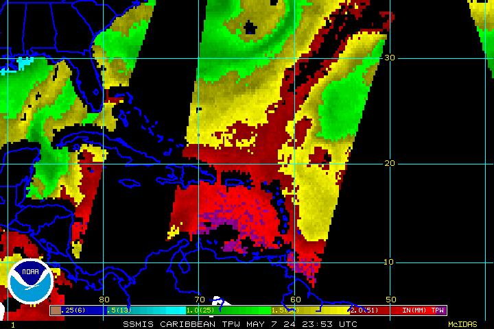
GOES Composite (E/W; time sensitive):

0 likes
-
CrazyC83
- Professional-Met
- Posts: 34315
- Joined: Tue Mar 07, 2006 11:57 pm
- Location: Deep South, for the first time!
000
UZNT13 KNHC 230450
XXAA 73047 99200 70694 07909 99980 28017 12022 00677 ///// /////
92517 25017 13027 85259 21204 11527 70931 15659 09516 88999 77999
31313 09608 80417
61616 AF303 0709A IRENE OB 19
62626 SPL 2003N06944W 0422 MBL WND 13026 AEV 20802 DLM WND 12023
980696 WL150 12024 084 REL 2002N06941W 041741 SPG 2002N06943W 042
133 =
XXBB 73048 99200 70694 07909 00980 28017 11850 21204 22770 17009
33718 17857 44696 14859
21212 00980 12022 11933 13029 22921 13027 33904 13030 44850 11527
55824 10525 66797 12522 77749 11512 88707 08514 99696 10018
31313 09608 80417
61616 AF303 0709A IRENE OB 19
62626 SPL 2003N06944W 0422 MBL WND 13026 AEV 20802 DLM WND 12023
980696 WL150 12024 084 REL 2002N06941W 041741 SPG 2002N06943W 042
133 =
;
980/22 kt. Pressure likely 978mb.
0 likes
the general convective pattern and symmetry continue to improve. the latest vdm indicates the strengthening process appears to have stopped; earlier they reported a closed wall... now it is open and the pressure has been steady. still, i think hispaniola is holding it back and considering the fact that it has been able strengthen and then hold its own in close proximity to that island is telling. in other words, once it pulls away this thing should rip. a floyd-esque cat 4 in the bahamas would not surprise me at all.
The posts in this forum are NOT official forecast and should not be used as such. They are just the opinion of the poster and may or may not be backed by sound meteorological data. They are NOT endorsed by any professional institution or storm2k.org. For official information, please refer to the NHC and NWS products.
The posts in this forum are NOT official forecast and should not be used as such. They are just the opinion of the poster and may or may not be backed by sound meteorological data. They are NOT endorsed by any professional institution or storm2k.org. For official information, please refer to the NHC and NWS products.
0 likes
-
CrazyC83
- Professional-Met
- Posts: 34315
- Joined: Tue Mar 07, 2006 11:57 pm
- Location: Deep South, for the first time!
000
URNT15 KNHC 230451
AF303 0709A IRENE HDOB 41 20110823
044100 2106N 07034W 6967 03159 //// +105 //// 051045 046 035 000 05
044130 2107N 07036W 6967 03159 //// +104 //// 050047 048 034 000 05
044200 2109N 07037W 6967 03162 //// +098 //// 052047 048 /// /// 05
044230 2110N 07039W 6967 03166 //// +090 //// 055046 047 033 000 05
044300 2112N 07041W 6966 03165 //// +084 //// 057047 049 033 000 05
044330 2113N 07043W 6979 03153 //// +087 //// 055046 047 /// /// 05
044400 2115N 07044W 6966 03167 //// +085 //// 055046 047 027 001 05
044430 2116N 07046W 6967 03168 //// +081 //// 055046 046 023 001 05
044500 2117N 07047W 6963 03177 //// +080 //// 053046 047 /// /// 05
044530 2117N 07050W 6967 03173 //// +083 //// 048045 046 /// /// 05
044600 2115N 07050W 6966 03171 //// +083 //// 047042 043 /// /// 05
044630 2113N 07049W 6969 03165 //// +081 //// 047042 042 026 000 05
044700 2111N 07049W 6959 03174 //// +080 //// 050040 041 030 000 01
044730 2108N 07049W 6965 03167 //// +082 //// 046038 038 032 000 01
044800 2106N 07049W 6969 03161 //// +087 //// 040039 039 028 000 01
044830 2104N 07048W 6967 03161 //// +092 //// 041039 039 031 000 01
044900 2101N 07048W 6969 03158 //// +098 //// 042039 039 031 000 01
044930 2059N 07048W 6968 03159 //// +102 //// 037037 038 029 000 01
045000 2056N 07048W 6966 03161 //// +105 //// 033036 037 031 000 01
045030 2054N 07048W 6967 03157 //// +105 //// 033037 037 030 000 01
$$
;
0 likes
Who is online
Users browsing this forum: No registered users and 38 guests