WPAC: NANMADOL - Tropical Storm (14W/Mina)

Moderator: S2k Moderators

Message
Author
User avatar
euro6208
Category 5
Category 5
Posts: 18547
Joined: Mon Mar 08, 2004 7:50 pm
Location: Guam

Re: WPAC: NANMADOL - Typhoon (14W/Mina)

#401 Postby euro6208 » Fri Aug 26, 2011 10:57 am

Image

looks like nanmadol will be passing over 2 very warm areas, north of luzon, and east of taiwan so if this typhoon stays offshore, it would most likely remain powerful
0 likes   
Remember, all of my post aren't official. For official warnings and discussions, Please refer to your local NWS products...

NWS for the Western Pacific

https://www.weather.gov/gum/

RobWESTPACWX
WestPACMet
WestPACMet
Posts: 1616
Joined: Fri Sep 17, 2010 2:26 am
Location: Tokyo, Japan
Contact:

Re: WPAC: NANMADOL - Typhoon (14W/Mina)

#402 Postby RobWESTPACWX » Fri Aug 26, 2011 1:44 pm

A thought, but wanted to get a second thought and I know long range, but this could effect how Japan is effected by this storm.

After 15W effects the region and gets kicked off to the NE a high pressure is going to ridge behind it.. thoughts on this blocking Nanmadol and cuasing it to continue North..

Image
0 likes   
Satellites, Charts and Forecasting tools for East Asia at WESTERNPACIFICWEATHER.COM

bexar
Tropical Storm
Tropical Storm
Posts: 182
Joined: Sat Aug 20, 2011 11:23 am

#403 Postby bexar » Fri Aug 26, 2011 2:24 pm

it's amazing how the same names in 2004 became super typhoons again in 2011... Songda, Muifa, Ma-on, Nanmadol...
0 likes   

supercane
S2K Supporter
S2K Supporter
Posts: 2856
Joined: Wed Sep 16, 2009 8:27 pm

#404 Postby supercane » Fri Aug 26, 2011 2:33 pm

WTPQ50 RJTD 261800
RSMC TROPICAL CYCLONE ADVISORY
NAME TY 1111 NANMADOL (1111)
ANALYSIS
PSTN 261800UTC 17.9N 122.8E GOOD
MOVE NW 06KT
PRES 920HPA
MXWD 105KT
GUST 150KT
50KT 100NM
30KT 200NM
FORECAST
24HF 271800UTC 19.8N 122.1E 70NM 70%
MOVE NNW SLOWLY
PRES 925HPA
MXWD 100KT
GUST 140KT
48HF 281800UTC 21.5N 121.7E 110NM 70%
MOVE N SLOWLY
PRES 930HPA
MXWD 095KT
GUST 135KT
72HF 291800UTC 22.6N 121.5E 160NM 70%
MOVE N SLOWLY
PRES 940HPA
MXWD 085KT
GUST 120KT
96HF 301800UTC 23.6N 121.8E 280NM 70%
MOVE NNE SLOWLY
120HF 311800UTC 24.5N 122.6E 375NM 70%
MOVE NE SLOWLY =
Image
TPPN11 PGTW 261809
A. SUPER TYPHOON 14W (NANMADOL)
B. 26/1732Z
C. 18.0N
D. 122.7E
E. ONE/MTSAT
F. T6.0/7.0/W0.5/24HRS STT: W0.5/06HRS
G. IR/EIR
H. REMARKS: 01A/PBO EYE/ANMTN. 17NM OW EYE SURROUNDED BY BLK
YIELDS AN E# OF 5.5. ADDED .5 FOR EYE ADJUSTMENT TO YIELD A DT
OF 6.0. PT AND MET AGREE. DBO DT.
I. ADDITIONAL POSITIONS: NONE
UEHARA
Image
0 likes   

RobWESTPACWX
WestPACMet
WestPACMet
Posts: 1616
Joined: Fri Sep 17, 2010 2:26 am
Location: Tokyo, Japan
Contact:

Re: WPAC: NANMADOL - Typhoon (14W/Mina)

#405 Postby RobWESTPACWX » Fri Aug 26, 2011 2:48 pm

Can't find any obs from Aparri, think there stations is down given the eye is right off the coast, closest I got is a station along the NW coast showing 12kts.

AXX 26191 98232 41560 83612 10264 20243 49941 5//// 76066 8557/ 333 56999 85620 88358
0 likes   
Satellites, Charts and Forecasting tools for East Asia at WESTERNPACIFICWEATHER.COM

phwxenthusiast
Category 2
Category 2
Posts: 637
Joined: Wed Mar 24, 2010 3:10 am
Location: Holbrook, NY (Long Island)

#406 Postby phwxenthusiast » Fri Aug 26, 2011 3:04 pm

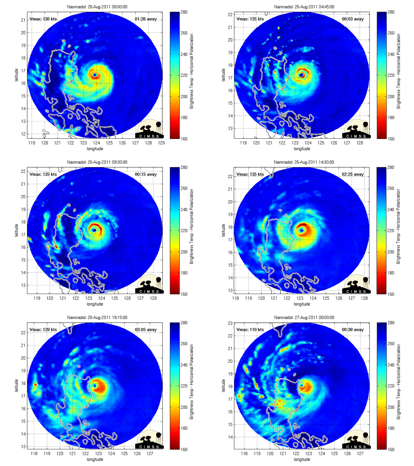
this could have weakened to 125-130kts now based on IR and Dvorak estimates...

Nanmadol has been undergoing an eyewall replacement cycle for the past 12 hours, as i was alluding to yesterday... and it seems to be going well by looking at how it had maintained that almost-perfect eye despite the EWRC... (we've seen a couple of botched EWRC this year in the WPAC)

Image

the last few frames on IR suggest this may be moving more west than predicted... it may actually brush Sta. Ana, Cagayan, based on the trends... if it exits Luzon unscathed, Nanmadol will still have at least 24 hours over Luzon Strait and based on the good progress of the EWRC so far, i believe this may actually have one more burst of intensification before moving near Taiwan...

The posts in this forum are NOT official forecast and should not be used as such. They are just the opinion of the poster and may or may not be backed by sound meteorological data. They are NOT endorsed by any professional institution or storm2k.org. For official information, please refer to the JTWC and JMA products.
0 likes   

RobWESTPACWX
WestPACMet
WestPACMet
Posts: 1616
Joined: Fri Sep 17, 2010 2:26 am
Location: Tokyo, Japan
Contact:

Re: WPAC: NANMADOL - Typhoon (14W/Mina)

#407 Postby RobWESTPACWX » Fri Aug 26, 2011 3:09 pm

I really hope everyone got out of the way of this in time. This is another scary sat shot over the PI.

Image

As of right now I have not seen any news besides the two missing fishermen, I'm sure as the sun rises and the day goes on more news will come in.
0 likes   
Satellites, Charts and Forecasting tools for East Asia at WESTERNPACIFICWEATHER.COM

RobWESTPACWX
WestPACMet
WestPACMet
Posts: 1616
Joined: Fri Sep 17, 2010 2:26 am
Location: Tokyo, Japan
Contact:

Re: WPAC: NANMADOL - Typhoon (14W/Mina)

#408 Postby RobWESTPACWX » Fri Aug 26, 2011 3:12 pm

Really does look like that outer eye wall could brush the coast. I'm sure if James is around he probably is kicking himself for not heading out to Aparri for this one. You can't get them all though.
0 likes   
Satellites, Charts and Forecasting tools for East Asia at WESTERNPACIFICWEATHER.COM

supercane
S2K Supporter
S2K Supporter
Posts: 2856
Joined: Wed Sep 16, 2009 8:27 pm

#409 Postby supercane » Fri Aug 26, 2011 4:03 pm

WTPN31 PGTW 262100
MSGID/GENADMIN/NAVMARFCSTCEN PEARL HARBOR HI/JTWC//
SUBJ/TROPICAL CYCLONE WARNING//
RMKS/
1. TYPHOON 14W (NANMADOL) WARNING NR 017
02 ACTIVE TROPICAL CYCLONES IN NORTHWESTPAC
MAX SUSTAINED WINDS BASED ON ONE-MINUTE AVERAGE
WIND RADII VALID OVER OPEN WATER ONLY
---
WARNING POSITION:
261800Z --- NEAR 18.0N 122.7E
MOVEMENT PAST SIX HOURS - 305 DEGREES AT 07 KTS
POSITION ACCURATE TO WITHIN 025 NM
POSITION BASED ON EYE FIXED BY SATELLITE
PRESENT WIND DISTRIBUTION:
MAX SUSTAINED WINDS - 120 KT, GUSTS 145 KT
WIND RADII VALID OVER OPEN WATER ONLY
RADIUS OF 064 KT WINDS - 050 NM NORTHEAST QUADRANT
050 NM SOUTHEAST QUADRANT
050 NM SOUTHWEST QUADRANT
050 NM NORTHWEST QUADRANT
RADIUS OF 050 KT WINDS - 080 NM NORTHEAST QUADRANT
080 NM SOUTHEAST QUADRANT
080 NM SOUTHWEST QUADRANT
080 NM NORTHWEST QUADRANT
RADIUS OF 034 KT WINDS - 120 NM NORTHEAST QUADRANT
120 NM SOUTHEAST QUADRANT
100 NM SOUTHWEST QUADRANT
120 NM NORTHWEST QUADRANT
REPEAT POSIT: 18.0N 122.7E
---
FORECASTS:
12 HRS, VALID AT:
270600Z --- 18.9N 122.1E
MAX SUSTAINED WINDS - 125 KT, GUSTS 150 KT
WIND RADII VALID OVER OPEN WATER ONLY
RADIUS OF 064 KT WINDS - 045 NM NORTHEAST QUADRANT
045 NM SOUTHEAST QUADRANT
045 NM SOUTHWEST QUADRANT
045 NM NORTHWEST QUADRANT
RADIUS OF 050 KT WINDS - 080 NM NORTHEAST QUADRANT
080 NM SOUTHEAST QUADRANT
080 NM SOUTHWEST QUADRANT
080 NM NORTHWEST QUADRANT
RADIUS OF 034 KT WINDS - 125 NM NORTHEAST QUADRANT
125 NM SOUTHEAST QUADRANT
110 NM SOUTHWEST QUADRANT
125 NM NORTHWEST QUADRANT
VECTOR TO 24 HR POSIT: 335 DEG/ 06 KTS
---
24 HRS, VALID AT:
271800Z --- 19.9N 121.6E
MAX SUSTAINED WINDS - 120 KT, GUSTS 145 KT
WIND RADII VALID OVER OPEN WATER ONLY
RADIUS OF 064 KT WINDS - 045 NM NORTHEAST QUADRANT
045 NM SOUTHEAST QUADRANT
045 NM SOUTHWEST QUADRANT
045 NM NORTHWEST QUADRANT
RADIUS OF 050 KT WINDS - 075 NM NORTHEAST QUADRANT
075 NM SOUTHEAST QUADRANT
075 NM SOUTHWEST QUADRANT
075 NM NORTHWEST QUADRANT
RADIUS OF 034 KT WINDS - 130 NM NORTHEAST QUADRANT
130 NM SOUTHEAST QUADRANT
115 NM SOUTHWEST QUADRANT
125 NM NORTHWEST QUADRANT
VECTOR TO 36 HR POSIT: 350 DEG/ 05 KTS
---
36 HRS, VALID AT:
280600Z --- 20.8N 121.4E
MAX SUSTAINED WINDS - 115 KT, GUSTS 140 KT
WIND RADII VALID OVER OPEN WATER ONLY
RADIUS OF 064 KT WINDS - 045 NM NORTHEAST QUADRANT
045 NM SOUTHEAST QUADRANT
045 NM SOUTHWEST QUADRANT
045 NM NORTHWEST QUADRANT
RADIUS OF 050 KT WINDS - 075 NM NORTHEAST QUADRANT
075 NM SOUTHEAST QUADRANT
075 NM SOUTHWEST QUADRANT
075 NM NORTHWEST QUADRANT
RADIUS OF 034 KT WINDS - 135 NM NORTHEAST QUADRANT
130 NM SOUTHEAST QUADRANT
120 NM SOUTHWEST QUADRANT
130 NM NORTHWEST QUADRANT
VECTOR TO 48 HR POSIT: 360 DEG/ 07 KTS
---
EXTENDED OUTLOOK:
48 HRS, VALID AT:
281800Z --- 22.1N 121.4E
MAX SUSTAINED WINDS - 110 KT, GUSTS 135 KT
WIND RADII VALID OVER OPEN WATER ONLY
RADIUS OF 064 KT WINDS - 045 NM NORTHEAST QUADRANT
045 NM SOUTHEAST QUADRANT
045 NM SOUTHWEST QUADRANT
045 NM NORTHWEST QUADRANT
RADIUS OF 050 KT WINDS - 075 NM NORTHEAST QUADRANT
075 NM SOUTHEAST QUADRANT
070 NM SOUTHWEST QUADRANT
050 NM NORTHWEST QUADRANT
RADIUS OF 034 KT WINDS - 135 NM NORTHEAST QUADRANT
135 NM SOUTHEAST QUADRANT
100 NM SOUTHWEST QUADRANT
095 NM NORTHWEST QUADRANT
VECTOR TO 72 HR POSIT: 005 DEG/ 03 KTS
---
72 HRS, VALID AT:
291800Z --- 23.2N 121.5E
MAX SUSTAINED WINDS - 090 KT, GUSTS 110 KT
WIND RADII VALID OVER OPEN WATER ONLY
RADIUS OF 064 KT WINDS - 035 NM NORTHEAST QUADRANT
035 NM SOUTHEAST QUADRANT
035 NM SOUTHWEST QUADRANT
035 NM NORTHWEST QUADRANT
RADIUS OF 050 KT WINDS - 065 NM NORTHEAST QUADRANT
065 NM SOUTHEAST QUADRANT
050 NM SOUTHWEST QUADRANT
050 NM NORTHWEST QUADRANT
RADIUS OF 034 KT WINDS - 135 NM NORTHEAST QUADRANT
135 NM SOUTHEAST QUADRANT
080 NM SOUTHWEST QUADRANT
080 NM NORTHWEST QUADRANT
VECTOR TO 96 HR POSIT: 015 DEG/ 03 KTS
---
LONG RANGE OUTLOOK:
---
96 HRS, VALID AT:
301800Z --- 24.2N 121.8E
MAX SUSTAINED WINDS - 080 KT, GUSTS 100 KT
WIND RADII VALID OVER OPEN WATER ONLY
VECTOR TO 120 HR POSIT: 030 DEG/ 03 KTS
---
120 HRS, VALID AT:
311800Z --- 25.1N 122.4E
MAX SUSTAINED WINDS - 065 KT, GUSTS 080 KT
WIND RADII VALID OVER OPEN WATER ONLY
---
REMARKS:
262100Z POSITION NEAR 18.2N 122.6E.
TYPHOON (TY) 14W (NANMADOL), LOCATED APPROXIMATELY 300 NM WEST-
SOUTHWEST OF KADENA AB, OKINAWA, HAS TRACKED NORTHWESTWARD AT 07
KNOTS OVER THE PAST SIX HOURS. ANIMATED INFRARED SATELLITE IMAGERY
SHOWS THAT ALTHOUGH LAND INTERACTION WITH LUZON IS ERODING THE
WESTERN SEMICIRCLE OF THE SYSTEM, THE SYSTEM MAINTAINS A 17 NM EYE
WITH NO INDICATIONS OF FILLING. A 261755Z AMSRE IMAGE REVEALS THAT
TY 14W MAINTAINS A THICK, CONCENTRIC EYEWALL. AGENCY DVORAK
INTENSITY ASSESSMENTS ALSO REMAIN HIGH. ANIMATED WATER VAPOR IMAGERY
SHOWS DUAL OUTFLOW CHANNELS, WITH THE POLEWARD CHANNEL VENTING INTO
A TUTT CELL NORTHEAST OF TAIWAN. TY 14W IS BEING NUDGED POLEWARD BY
WEAK ANTICYCLONE EMBEDDED IN THE NEAR EQUATORIAL RIDGE. THE
ANTICYCLONE EXISTS AT THE WESTERN END OF THE RIDGE. TY 14W HAS
PEAKED IN INTENSITY AND WILL BEGIN AN OVERALL DOWNTREND. IN THE
SHORT TERM, HOWEVER, THE HIGHLY FAVORABLE OUTFLOW CONDITIONS WILL
ALLOW FOR SOME MILD RE-INTENSIFICATION AS THE SYSTEM CLEARS LUZON.
BY TAU 48, IMPEDIMENTS DUE TO LAND INTERACTION WITH TAIWAN AND A
POSSIBLE EYEWALL REPLACEMENT CYCLE WILL BRING ABOUT A STEADY
WEAKENING TREND. IN THE MID TO LONG RANGE, THE NEAR EQUATORIAL RIDGE
IS EXPECTED TO BUILD AND THRUST OVER THE SOUTHERN RYUKUS, KEEPING
THE SYSTEM ON A POLEWARD TRACK. THE JTWC TRACK FORECAST IS CLOSE TO
CONSENSUS AND THE JGSM MODEL. MAXIMUM SIGNIFICANT WAVE HEIGHT AT
261800Z IS 34 FEET. NEXT WARNINGS AT 270300Z, 270900Z, 271500Z AND
272100Z. REFER TO TROPICAL STORM 15W (TALAS) WARNINGS (WTPN32 PGTW)
FOR SIX-HOURLY UPDATES.//
NNNN
Image
0 likes   

RobWESTPACWX
WestPACMet
WestPACMet
Posts: 1616
Joined: Fri Sep 17, 2010 2:26 am
Location: Tokyo, Japan
Contact:

Re: WPAC: NANMADOL - Typhoon (14W/Mina)

#410 Postby RobWESTPACWX » Fri Aug 26, 2011 4:23 pm

JTWC pulling a little farther west now, not counting the DCI anymore this seems more and more likely..
0 likes   
Satellites, Charts and Forecasting tools for East Asia at WESTERNPACIFICWEATHER.COM

tim_in_ga
Tropical Storm
Tropical Storm
Posts: 125
Joined: Fri Jun 10, 2005 9:30 pm
Location: Buford, GA

Re: WPAC: NANMADOL - Typhoon (14W/Mina)

#411 Postby tim_in_ga » Fri Aug 26, 2011 4:30 pm

RobWESTPACWX wrote:JTWC pulling a little farther west now, not counting the DCI anymore this seems more and more likely..


This is bad for Taiwan. Looks like at least 4 days of this thing riding the east coast. Landslides are going to be a big concern.
0 likes   

phwxenthusiast
Category 2
Category 2
Posts: 637
Joined: Wed Mar 24, 2010 3:10 am
Location: Holbrook, NY (Long Island)

#412 Postby phwxenthusiast » Fri Aug 26, 2011 5:25 pm

eyewall now brushing Cabutunan Point according to PAGASA
still no radar image though tsk tsk :roll:
0 likes   

oaba09
S2K Supporter
S2K Supporter
Posts: 1496
Age: 37
Joined: Thu Oct 01, 2009 10:02 am
Location: Valenzuela, Philippines
Contact:

#413 Postby oaba09 » Fri Aug 26, 2011 5:43 pm

latest from JMA:
Image

TY 1111 (NANMADOL)
Issued at 21:40 UTC, 26 August 2011
<Analyses at 26/21 UTC>
Scale -
Intensity Very Intense
Center position N18°00'(18.0°)
E122°30'(122.5°)
Direction and speed of movement WNW 10km/h(6kt)
Central pressure 920hPa
Maximum wind speed near the center 55m/s(105kt)
Maximum wind gust speed 75m/s(150kt)
Area of 50kt winds or more Wide 190km(100NM)
Area of 30kt winds or more Wide 370km(200NM)

<Forecast for 27/21 UTC>
Intensity Very Strong
Center position of probability circle N20°05'(20.1°)
E121°50'(121.8°)
Direction and speed of movement NNW 10km/h(6kt)
Central pressure 925hPa
Maximum wind speed near the center 50m/s(100kt)
Maximum wind gust speed 70m/s(140kt)
Radius of probability circle 130km(70NM)
Storm warning area Wide 300km(160NM)

<Forecast for 28/18 UTC>
Intensity Very Strong
Center position of probability circle N21°30'(21.5°)
E121°40'(121.7°)
Direction and speed of movement N Slowly
Central pressure 930hPa
Maximum wind speed near the center 50m/s(95kt)
Maximum wind gust speed 70m/s(135kt)
Radius of probability circle 200km(110NM)
Storm warning area Wide 350km(190NM)

<Forecast for 29/18 UTC>
Intensity Very Strong
Center position of probability circle N22°35'(22.6°)
E121°30'(121.5°)
Direction and speed of movement N Slowly
Central pressure 940hPa
Maximum wind speed near the center 45m/s(85kt)
Maximum wind gust speed 60m/s(120kt)
Radius of probability circle 300km(160NM)
Storm warning area Wide 430km(230NM)

<Forecast for 30/18 UTC>
Center position of probability circle N23°35'(23.6°)
E121°50'(121.8°)
Direction and speed of movement NNE Slowly
Radius of probability circle 520km(280NM)

<Forecast for 31/18 UTC>
Center position of probability circle N24°30'(24.5°)
E122°35'(122.6°)
Direction and speed of movement NE Slowly
Radius of probability circle 700km(375NM)
0 likes   

User avatar
StormingB81
S2K Supporter
S2K Supporter
Posts: 5676
Age: 42
Joined: Thu Aug 27, 2009 1:45 am
Location: Rockledge, Florida

#414 Postby StormingB81 » Fri Aug 26, 2011 6:05 pm

Looking like Okinawa may not have to much to worry about man though feel bad for tawain though!
0 likes   

oaba09
S2K Supporter
S2K Supporter
Posts: 1496
Age: 37
Joined: Thu Oct 01, 2009 10:02 am
Location: Valenzuela, Philippines
Contact:

#415 Postby oaba09 » Fri Aug 26, 2011 6:17 pm

There are reports indicating that power has already been cut in cagayan. Landlines are also down. Per PAGASA, landfall occured at 5:30 AM local time(2130Z)

In metro manila, it has been raining continuously since dawn(most likely the effect of the enhanced SW monsoon)....
0 likes   

User avatar
Amoygal
Tropical Low
Tropical Low
Posts: 16
Joined: Sun May 29, 2011 8:46 pm
Location: Taiwan

Re: WPAC: NANMADOL - Typhoon (14W/Mina)

#416 Postby Amoygal » Fri Aug 26, 2011 7:50 pm

Wow, we're going to get soaked over here in Taiwan. It's been raining steadily in northern and eastern Taiwan already since last night (still raining hard now), and we've had drenching thunderstorms a couple times in the last few days, so it's already pretty wet around here. I'm concerned about the east coast, and I hope precautions are being taken to remove people from landslide-prone areas. We don't need a repeat of what happened during Morakot in 2009, or last year when a tour van got swept off the coastal road due to a landslide. Hopefully lessons have been learned and people realize that we don't have to have a direct hit from the eye for a typhoon to be dangerous here, especially considering Taiwan's topography on the east coast.
0 likes   

supercane
S2K Supporter
S2K Supporter
Posts: 2856
Joined: Wed Sep 16, 2009 8:27 pm

#417 Postby supercane » Fri Aug 26, 2011 8:07 pm

WTPQ20 RJTD 270000
RSMC TROPICAL CYCLONE ADVISORY
NAME TY 1111 NANMADOL (1111)
ANALYSIS
PSTN 270000UTC 18.1N 122.4E GOOD
MOVE WNW SLOWLY
PRES 930HPA
MXWD 100KT
GUST 140KT
50KT 70NM
30KT 200NM
FORECAST
24HF 280000UTC 20.0N 121.8E 70NM 70%
MOVE NNW SLOWLY
PRES 930HPA
MXWD 100KT
GUST 140KT
48HF 290000UTC 21.6N 121.6E 110NM 70%
MOVE N SLOWLY
PRES 930HPA
MXWD 100KT
GUST 140KT
72HF 300000UTC 22.8N 121.5E 160NM 70%
MOVE N SLOWLY
PRES 940HPA
MXWD 085KT
GUST 120KT =
Image
Last edited by supercane on Fri Aug 26, 2011 8:09 pm, edited 1 time in total.
0 likes   

Typhoon Hunter
WesternPacificWeather.com
Posts: 1215
Age: 40
Joined: Wed Oct 11, 2006 11:37 am
Location: Hong Kong
Contact:

Re: WPAC: NANMADOL - Typhoon (14W/Mina)

#418 Postby Typhoon Hunter » Fri Aug 26, 2011 8:08 pm

Booked my ticket and arrive in Taipei tomorrow morning at 11am. Going to be a long and hard grind this one with the biggest threats being flooding and landslides. I'll be posting more updates here and on Twitter @typhoonfury as thing progress.

Think Taiwan is taking one for the team here and sparing Okinawa something nasty!
0 likes   
James - Documenting typhoons...

http://www.youtube.com/TyphoonHunter

rdhdstpchld
Tropical Depression
Tropical Depression
Posts: 79
Joined: Mon May 09, 2011 3:47 am

Re: WPAC: NANMADOL - Typhoon (14W/Mina)

#419 Postby rdhdstpchld » Fri Aug 26, 2011 8:29 pm

Typhoon Hunter wrote:Booked my ticket and arrive in Taipei tomorrow morning at 11am. Going to be a long and hard grind this one with the biggest threats being flooding and landslides. I'll be posting more updates here and on Twitter @typhoonfury as thing progress.

Think Taiwan is taking one for the team here and sparing Okinawa something nasty!


Be Safe James! What do we think for "after Taiwan"? Stay at the Howard...we liked it! LOL...tell them you want a room with a view... :lol:
0 likes   

oaba09
S2K Supporter
S2K Supporter
Posts: 1496
Age: 37
Joined: Thu Oct 01, 2009 10:02 am
Location: Valenzuela, Philippines
Contact:

Re: WPAC: NANMADOL - Typhoon (14W/Mina)

#420 Postby oaba09 » Fri Aug 26, 2011 8:37 pm

Typhoon Hunter wrote:Booked my ticket and arrive in Taipei tomorrow morning at 11am. Going to be a long and hard grind this one with the biggest threats being flooding and landslides. I'll be posting more updates here and on Twitter @typhoonfury as thing progress.

Think Taiwan is taking one for the team here and sparing Okinawa something nasty!


Should've went to cagayan LOL

forecasting models missed the mark on this one...
0 likes   


Return to “2011”

Who is online

Users browsing this forum: No registered users and 12 guests