ATL: DON - Remnant - Discussion

Moderator: S2k Moderators

Message
Author
User avatar
perk
Category 3
Category 3
Posts: 825
Joined: Mon Aug 09, 2004 9:35 am
Location: Richmond Texas

Re: ATL: INVEST 90L - Discussion

#501 Postby perk » Sun Jul 24, 2011 9:26 am

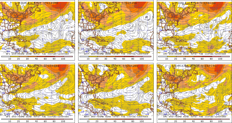
wxman57 wrote:Not NE shear, increased low-level flow I mentioned yesterday. Lower level winds now 25-35 kts south of the DR. That's disrupting convection. Have to wait for it to slow down by the Yucatan.


Wxman57 do you still think 90L has a chance at development.
0 likes   

User avatar
perk
Category 3
Category 3
Posts: 825
Joined: Mon Aug 09, 2004 9:35 am
Location: Richmond Texas

Re:

#502 Postby perk » Sun Jul 24, 2011 9:45 am

Dean4Storms wrote:Don't see anything becoming of it. Next!


Like wxman57 said, we should wait until it slows down around the Yucatan. That's where develop may take place.
0 likes   

User avatar
tailgater
S2K Supporter
S2K Supporter
Posts: 3339
Joined: Sun Jul 11, 2004 9:13 pm
Location: St. Amant La.

Re: ATL: INVEST 90L - Discussion

#503 Postby tailgater » Sun Jul 24, 2011 9:46 am

This still has a decent low level structure that is easily seen centered over Hispanola now that there are no T-storms in the way.

Image
0 likes   
The following post is NOT an official forecast and should not be used as such. It is just the opinion of the poster and may or may not be backed by sound meteorological data. It is NOT endorsed by any professional institution including storm2k.org For Official Information please refer to the NHC and NWS products.

User avatar
ConvergenceZone
Category 5
Category 5
Posts: 5194
Joined: Fri Jul 29, 2005 1:40 am
Location: Northern California

#504 Postby ConvergenceZone » Sun Jul 24, 2011 11:15 am

Wow, so it's not even an Invest anymore? I didn't expect development, but I also didn't expect the Invest going completely away..... Talk about obliterating into nothing.....
Moving on...........
0 likes   

User avatar
drezee
S2K Supporter
S2K Supporter
Posts: 3664
Joined: Mon Jun 09, 2003 12:49 pm
Location: FL

Re: ATL: INVEST 90L - Discussion

#505 Postby drezee » Sun Jul 24, 2011 11:16 am

It is not dead yet. It is still a match waiting for a powder keg. It may find it or it may get blown out by the Cuba mountains first.
0 likes   

User avatar
ConvergenceZone
Category 5
Category 5
Posts: 5194
Joined: Fri Jul 29, 2005 1:40 am
Location: Northern California

Re: ATL: INVEST 90L - Discussion

#506 Postby ConvergenceZone » Sun Jul 24, 2011 11:25 am

drezee wrote:It is not dead yet. It is still a match waiting for a powder keg. It may find it or it may get blown out by the Cuba mountains first.


but at least before there was something for it to develop "from" But now that "from" seems to be just about gone.....
The mountains will probably take care of whatever is left of it at the moment.
0 likes   

User avatar
HURAKAN
Professional-Met
Professional-Met
Posts: 46086
Age: 38
Joined: Thu May 20, 2004 4:34 pm
Location: Key West, FL
Contact:

#507 Postby HURAKAN » Sun Jul 24, 2011 11:26 am

OUTLOOK FOR SUCCEEDING DAY: POSSIBLE LOW LEVEL
INVEST NEAR 21.0N 84.0W AT 26/1800Z.
3. REMARK: BEGIN 6-HOURLY FIXES AT 27/00Z IF SYSTEM DEVELOPS.
0 likes   

User avatar
HURAKAN
Professional-Met
Professional-Met
Posts: 46086
Age: 38
Joined: Thu May 20, 2004 4:34 pm
Location: Key West, FL
Contact:

Re:

#508 Postby HURAKAN » Sun Jul 24, 2011 11:27 am

ConvergenceZone wrote:Wow, so it's not even an Invest anymore? I didn't expect development, but I also didn't expect the Invest going completely away..... Talk about obliterating into nothing.....
Moving on...........


It's still an invest because it hasn't been deactivated in the ATCF but I guess because no models have been run since yesterday it dropped from the map.

AL, 90, 2011072412, , BEST, 0, 175N, 700W, 25, 1013, DB
0 likes   

Sanibel
Category 5
Category 5
Posts: 10375
Joined: Mon Aug 30, 2004 11:06 pm
Location: Offshore SW Florida

Re: ATL: INVEST 90L - Discussion

#509 Postby Sanibel » Sun Jul 24, 2011 11:54 am

If it does re-fire it will be about as big a come-back as you can get.
0 likes   

jinftl
Category 5
Category 5
Posts: 4312
Joined: Tue Aug 31, 2004 4:47 pm
Location: fort lauderdale, fl

Re: ATL: INVEST 90L - Discussion

#510 Postby jinftl » Sun Jul 24, 2011 11:57 am

Agree, there have been fully developed hurricanes that have succumbed to the mountains of hispanola and extended landmass of cuba...this invest had no chance since there wasn't really much in the way of organization prior to encountering these landmass obstacles.

If any remnants make it west of 80w, then we will have to see if anything is there to get going...or if it runs into another landmass again, this time the yucatan. Probably it's legacy will be just something that enhances typical afternoon thunderstorms in the greater antilles and yucatan. One of many invests to come...can't even say that it could make a comeback....that is overvaluing what it actually was/is....


ConvergenceZone wrote:
drezee wrote:It is not dead yet. It is still a match waiting for a powder keg. It may find it or it may get blown out by the Cuba mountains first.


but at least before there was something for it to develop "from" But now that "from" seems to be just about gone.....
The mountains will probably take care of whatever is left of it at the moment.
0 likes   

User avatar
Rgv20
S2K Supporter
S2K Supporter
Posts: 2466
Age: 38
Joined: Wed Jan 05, 2011 5:42 pm
Location: Edinburg/McAllen Tx

#511 Postby Rgv20 » Sun Jul 24, 2011 12:02 pm

90L is still on schedule to slow down in the NW Caribbean where it will have the best shot at development during the day Tuesday.

Image
0 likes   
The following post is NOT an official forecast and should not be used as such. It is just the opinion of the poster and may or may not be backed by sound meteorological data. It is NOT endorsed by any professional institution including storm2k.org For Official Information please refer to the NHC and NWS products.

User avatar
Rgv20
S2K Supporter
S2K Supporter
Posts: 2466
Age: 38
Joined: Wed Jan 05, 2011 5:42 pm
Location: Edinburg/McAllen Tx

#512 Postby Rgv20 » Sun Jul 24, 2011 12:08 pm

12zNam dropped 90l after being so consistent with it. On the other hand 0zUKMET tries to close off a low in the NW Caribbean by 60hrs Tuesday July 26.

0zUKMET
Image
0 likes   
The following post is NOT an official forecast and should not be used as such. It is just the opinion of the poster and may or may not be backed by sound meteorological data. It is NOT endorsed by any professional institution including storm2k.org For Official Information please refer to the NHC and NWS products.

User avatar
blp
Category 5
Category 5
Posts: 2840
Age: 46
Joined: Thu Sep 09, 2004 7:51 pm
Location: Miami, FL
Contact:

Re: ATL: INVEST 90L - Discussion

#513 Postby blp » Sun Jul 24, 2011 12:15 pm

I think a couple of years ago the GFS would have been all over this. It tended to develop quite a few phantom storms, so it is interesting to see how the upgrades have changed the model. I will be curious to see if the model plays out more conservatively towards development as the season goes forward.
0 likes   

CYCLONE MIKE
Category 5
Category 5
Posts: 2183
Joined: Tue Aug 31, 2004 6:04 pm
Location: Gonzales, LA

Re: ATL: INVEST 90L - Discussion

#514 Postby CYCLONE MIKE » Sun Jul 24, 2011 1:11 pm

Have been laying low for a while, just watching things come and go. This system aroused my interest some earlier this week, thinking it may have a chance even while many were thinking it was all systems go when it was just east of the islands . Have to say though it did look like it could take become at least a depression for a moment there. And of course models tracking it into the gulf. Anyway must agree with CZ this morning. Its done. Time to move on and look elsewhere. Whatever is left come tomorrow should be eaten up by Cuba next. Should bring some higher rain chances to some parts of south Texas next week, but nothing else. If it even makes it that far north. Could get pushed due west into Mexico again. Just for arguements sake maybe could still give it a < 2% chance of doing something down the road.
0 likes   

User avatar
HURAKAN
Professional-Met
Professional-Met
Posts: 46086
Age: 38
Joined: Thu May 20, 2004 4:34 pm
Location: Key West, FL
Contact:

#515 Postby HURAKAN » Sun Jul 24, 2011 1:12 pm

A TROPICAL WAVE OVER THE CENTRAL CARIBBEAN SEA AND HISPANIOLA IS
PRODUCING A FEW DISORGANIZED SHOWERS AND THUNDERSTORMS. SIGNIFICANT
DEVELOPMENT OF THIS SYSTEM IS NOT EXPECTED AS IT MOVES GENERALLY
WESTWARD NEAR 20 MPH AND INTERACTS WITH THE LAND MASSES OF
HISPANIOLA AND CUBA OVER THE NEXT DAY OR TWO. THIS SYSTEM HAS
A LOW CHANCE...10 PERCENT...OF BECOMING A TROPICAL CYCLONE DURING
THE NEXT 48 HOURS. LOCALLY HEAVY RAINFALL AND GUSTY WINDS ARE
POSSIBLE OVER HISPANIOLA...JAMAICA...AND EASTERN CUBA DURING THE
NEXT DAY OR SO.
0 likes   

User avatar
sunnyday
Category 5
Category 5
Posts: 1590
Joined: Thu Sep 04, 2003 8:16 pm

Re: ATL: INVEST 90L - Discussion

#516 Postby sunnyday » Sun Jul 24, 2011 1:17 pm

I was not surprised to see it gone from the map this morning. What's up next? Is anything out there that may develop any time soon? 8-)
0 likes   

rockyman
Category 5
Category 5
Posts: 1967
Joined: Thu Jun 26, 2003 12:24 pm
Location: Dauphin Island, AL

Re: ATL: INVEST 90L - Discussion

#517 Postby rockyman » Sun Jul 24, 2011 1:35 pm

It's worth noting that NHC didn't drop to zero percent at 2pm
0 likes   

User avatar
Ivanhater
Storm2k Moderator
Storm2k Moderator
Posts: 11161
Age: 38
Joined: Fri Jul 01, 2005 8:25 am
Location: Pensacola

Re: ATL: INVEST 90L - Discussion

#518 Postby Ivanhater » Sun Jul 24, 2011 1:53 pm

It likes the day time

Image
0 likes   
Michael

User avatar
South Texas Storms
Professional-Met
Professional-Met
Posts: 4226
Joined: Thu Jun 24, 2010 12:28 am
Location: Houston, TX

Re: ATL: INVEST 90L - Discussion

#519 Postby South Texas Storms » Sun Jul 24, 2011 1:55 pm

:uarrow: Yeah it doesn't look that bad on satellite right now. I don't think this system's development chances are at 0% yet. It still could try to get its act together in a few days.
0 likes   

BigB0882
S2K Supporter
S2K Supporter
Posts: 2284
Joined: Thu Jul 03, 2003 12:08 am
Location: Baton Rouge, LA
Contact:

#520 Postby BigB0882 » Sun Jul 24, 2011 2:26 pm

Of course NHC will leave it at 10%. Why put it at 0% and possibly get burned? There seems to be a small window of good conditions in a couple of days so might as well wait it out until then.
0 likes   


Return to “2011”

Who is online

Users browsing this forum: No registered users and 28 guests