ATL: EMILY - Remnants

Moderator: S2k Moderators

Message
Author
User avatar
GCANE
S2K Supporter
S2K Supporter
Posts: 11540
Joined: Mon Oct 22, 2007 8:03 am

Re: ATL: EMILY - Tropical Storm - Discussion

#5761 Postby GCANE » Wed Aug 03, 2011 7:59 am

Looks like that hot-tower has developed a strong core cell centered just a hair above 15N.


Image

Image

Image
0 likes   

User avatar
KWT
Category 5
Category 5
Posts: 31415
Joined: Tue Aug 17, 2004 11:02 am
Location: UK!!!

Re: ATL: EMILY - Tropical Storm - Discussion

#5762 Postby KWT » Wed Aug 03, 2011 8:01 am

Evil Jeremy wrote:
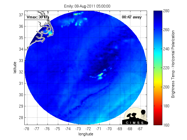
No one here is saying that the NHC is hopeless. This is tough for them to forecast. Emily has been fooling us all.


Indeed, the NHC have done a decent enough job thus with Emily and its not been that easy of a forecast neither.

I think they will need to shift abit west, but as Wxman57 said, still probably a little bit away from Florida.
0 likes   
Personal Forecast Disclaimer:
The posts in this forum are NOT official forecast and should not be used as such. They are just the opinion of the poster and may or may not be backed by sound meteorological data. They are NOT endorsed by any professional institution or storm2k.org. For official information, please refer to the NHC and NWS products

dwsqos2

Re: ATL: EMILY - Tropical Storm - Discussion

#5763 Postby dwsqos2 » Wed Aug 03, 2011 8:02 am

And now I see the weak LLC on the northwestern edge of the convection. My what a fascinating storm this is. I am not surprised, but stil.
0 likes   

User avatar
Bocadude85
Category 5
Category 5
Posts: 2990
Age: 38
Joined: Mon Apr 18, 2005 2:20 pm
Location: Honolulu,Hi

Re: ATL: EMILY - Tropical Storm - Discussion

#5764 Postby Bocadude85 » Wed Aug 03, 2011 8:02 am

Are we sure this will even be Emily tomorrow? Looks pretty pathetic to me..
0 likes   

Kory
Tropical Storm
Tropical Storm
Posts: 200
Age: 29
Joined: Tue Aug 02, 2011 11:32 am
Location: New Orleans, Louisiana

Re: ATL: EMILY - Tropical Storm - Discussion

#5765 Postby Kory » Wed Aug 03, 2011 8:03 am

Interesting to note, all of the BAM models have shifted whatever is left of Emily to the Southeast Gulf.
0 likes   

Kory
Tropical Storm
Tropical Storm
Posts: 200
Age: 29
Joined: Tue Aug 02, 2011 11:32 am
Location: New Orleans, Louisiana

Re: ATL: EMILY - Tropical Storm - Discussion

#5766 Postby Kory » Wed Aug 03, 2011 8:04 am

The BAM models are the green lines.

Image
0 likes   

User avatar
Bocadude85
Category 5
Category 5
Posts: 2990
Age: 38
Joined: Mon Apr 18, 2005 2:20 pm
Location: Honolulu,Hi

Re: ATL: EMILY - Tropical Storm - Discussion

#5767 Postby Bocadude85 » Wed Aug 03, 2011 8:05 am

Did the NHC change the track?? Go to this link and click Trop pts and look at the track.. that is not the current NHC track...

http://www.ssd.noaa.gov/goes/flt/t2/flash-vis.html

Now the track is back to the original track... just a second ago the track had this making landfall on the southern Haiti penisula..
Last edited by Bocadude85 on Wed Aug 03, 2011 8:09 am, edited 3 times in total.
0 likes   

User avatar
SFLcane
S2K Supporter
S2K Supporter
Posts: 10163
Age: 47
Joined: Sat Jun 05, 2010 1:44 pm
Location: Lake Worth Florida

Re: ATL: EMILY - Tropical Storm - Discussion

#5768 Postby SFLcane » Wed Aug 03, 2011 8:05 am

dwsqos2 wrote:And now I see the weak LLC on the northwestern edge of the convection. My what a fascinating storm this is. I am not surprised, but stil.


Nothing fascinating about this ugly tc...Right up there with fay as the most annoying storm to track.
0 likes   

User avatar
Evil Jeremy
S2K Supporter
S2K Supporter
Posts: 5463
Age: 32
Joined: Mon Apr 10, 2006 2:10 pm
Location: Los Angeles, CA

#5769 Postby Evil Jeremy » Wed Aug 03, 2011 8:06 am

Anyone know when the next recon is?
0 likes   
Frances 04 / Jeanne 04 / Katrina 05 / Wilma 05 / Fay 08 / Debby 12 / Andrea 13 / Colin 16 / Hermine 16 / Matthew 16 / Irma 17

Aric Dunn
Category 5
Category 5
Posts: 21238
Age: 42
Joined: Sun Sep 19, 2004 9:58 pm
Location: Ready for the Chase.
Contact:

#5770 Postby Aric Dunn » Wed Aug 03, 2011 8:07 am

The Gap is closing... latest cimss analysis.... better start turning soon..
0 likes   
Note: If I make a post that is brief. Please refer back to previous posts for the analysis or reasoning. I do not re-write/qoute what my initial post said each time.
If there is nothing before... then just ask :)

Space & Atmospheric Physicist, Embry-Riddle Aeronautical University,
I believe the sky is falling...

dwsqos2

Re: ATL: EMILY - Tropical Storm - Discussion

#5771 Postby dwsqos2 » Wed Aug 03, 2011 8:08 am

I guess sarcasm doesn't translate well.

Fay was glorious compared to this. Fay had an eye over central Florida and deepened to ~988 mb. This storm has barely ever has had a well-defined LLC. And now it gets to have even more severe shear issues.
0 likes   

User avatar
jdray
Category 3
Category 3
Posts: 853
Joined: Tue Aug 31, 2004 10:07 pm
Location: NE Florida

#5772 Postby jdray » Wed Aug 03, 2011 8:09 am

Models to the left, models to the right, Florida in between. Interesting patterns.

HWRF is a coast raker big time. UK Met and the Bamms would show some damage as well.
Looks like the trend is back west for now.
0 likes   

User avatar
KWT
Category 5
Category 5
Posts: 31415
Joined: Tue Aug 17, 2004 11:02 am
Location: UK!!!

#5773 Postby KWT » Wed Aug 03, 2011 8:10 am

Looks like either shear has picked up or the mid level flow has slowed down even more...

Either way not a healthy system, better hope it doesn't hit Hispaniola naked otherwise its game over...

That being said, looks like due west is carrying on, would be an amazing call from the Nogaps if it does end up dying out...
Last edited by KWT on Wed Aug 03, 2011 8:11 am, edited 1 time in total.
0 likes   
Personal Forecast Disclaimer:
The posts in this forum are NOT official forecast and should not be used as such. They are just the opinion of the poster and may or may not be backed by sound meteorological data. They are NOT endorsed by any professional institution or storm2k.org. For official information, please refer to the NHC and NWS products

User avatar
SFLcane
S2K Supporter
S2K Supporter
Posts: 10163
Age: 47
Joined: Sat Jun 05, 2010 1:44 pm
Location: Lake Worth Florida

Re: ATL: EMILY - Tropical Storm - Discussion

#5774 Postby SFLcane » Wed Aug 03, 2011 8:11 am

dwsqos2 wrote:I guess sarcasm doesn't translate well.

Fay was glorious compared to this. Fay had an eye over central Florida and deepened to ~988 mb. This storm has barely ever has had a well-defined LLC. And now it gets to have even more severe shear issues.


Hope this isn't a trend for this season.. :(
0 likes   

AHS2011
Tropical Storm
Tropical Storm
Posts: 134
Joined: Sun Jun 05, 2011 7:39 am

Re: ATL: EMILY - Tropical Storm - Discussion

#5775 Postby AHS2011 » Wed Aug 03, 2011 8:11 am

Is there a chance that Emily will not go over Hispaniola?
0 likes   
"People might not get all they work for in this world, but they must certainly work for all they get."- Frederick Douglass

Aric Dunn
Category 5
Category 5
Posts: 21238
Age: 42
Joined: Sun Sep 19, 2004 9:58 pm
Location: Ready for the Chase.
Contact:

#5776 Postby Aric Dunn » Wed Aug 03, 2011 8:11 am

the shift is coming at 12z..
0 likes   
Note: If I make a post that is brief. Please refer back to previous posts for the analysis or reasoning. I do not re-write/qoute what my initial post said each time.
If there is nothing before... then just ask :)

Space & Atmospheric Physicist, Embry-Riddle Aeronautical University,
I believe the sky is falling...

User avatar
cycloneye
Admin
Admin
Posts: 146021
Age: 69
Joined: Thu Oct 10, 2002 10:54 am
Location: San Juan, Puerto Rico

Re:

#5777 Postby cycloneye » Wed Aug 03, 2011 8:11 am

Evil Jeremy wrote:Anyone know when the next recon is?


Plane departs at 12:45 PM EDT.


Code: Select all

03/1800Z,04/0000Z       
       B. AFXXX 0805A EMILY     
       C. 03/1645Z                 
       D. 16.8N 69.3W             
       E. 03/1730Z TO 04/0000Z
       F. SFC TO 10,000 FT
0 likes   
Visit the Caribbean-Central America Weather Thread where you can find at first post web cams,radars
and observations from Caribbean basin members Click Here

User avatar
SouthFloridawx
S2K Supporter
S2K Supporter
Posts: 8346
Age: 46
Joined: Tue Jul 26, 2005 1:16 am
Location: Sarasota, FL
Contact:

Re:

#5778 Postby SouthFloridawx » Wed Aug 03, 2011 8:11 am

Or is it? :wink: Dun dun dunnnn...

KWT wrote:Looks like either shear has picked up or the mid level flow has slowed down even more...

Either way not a healthy system, better hope it doesn't hit Hispaniola naked otherwise its game over...
0 likes   

User avatar
KWT
Category 5
Category 5
Posts: 31415
Joined: Tue Aug 17, 2004 11:02 am
Location: UK!!!

Re: ATL: EMILY - Tropical Storm - Discussion

#5779 Postby KWT » Wed Aug 03, 2011 8:12 am

AHS2011 wrote:Is there a chance that Emily will not go over Hispaniola?


I think given the weakening trend Emily is showing, its certainly possible that it does just carry on to the W at 275/280...which would mean it will miss Hispaniola...
0 likes   
Personal Forecast Disclaimer:
The posts in this forum are NOT official forecast and should not be used as such. They are just the opinion of the poster and may or may not be backed by sound meteorological data. They are NOT endorsed by any professional institution or storm2k.org. For official information, please refer to the NHC and NWS products

User avatar
PTPatrick
Category 5
Category 5
Posts: 1831
Joined: Sat Jun 12, 2004 8:38 am

Re: ATL: EMILY - Models

#5780 Postby PTPatrick » Wed Aug 03, 2011 8:13 am

What I find funny is that a fair amount of the envelope has it going over a substantial portion of Cuba(granted, lots of bamms) but uk and canadian there too, yet the NHC barely covers the eastern tip. Just strange, normally their cone is almost dead on with the "cone" that is the spread of models. They seem really reluctant to shift west much, but then they generally only nudge the track a few miles at a time...much to the dismay of many STKers over the years, lol.
0 likes   


Return to “2011”

Who is online

Users browsing this forum: No registered users and 12 guests