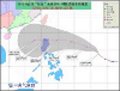
The sad thing is that we have so little time to prepare as 10w is already near.
What would steer this system from its current location toward Northern Luzon (as JTWC track suggest)?
WPAC: NOCK-TEN (Juaning) - Tropical Depression
Moderator: S2k Moderators
-
dhoeze
- Tropical Storm

- Posts: 130
- Age: 44
- Joined: Tue Oct 27, 2009 2:32 am
- Location: Manila, Philippines
Re: WPAC: TEN - Tropical Depression
0 likes
"Productivity is never an accident. It is always the result of a commitment to excellence, intelligent planning, and focused effort."
-
phwxenthusiast
- Category 2

- Posts: 637
- Joined: Wed Mar 24, 2010 3:10 am
- Location: Holbrook, NY (Long Island)
Re: WPAC: TEN - Tropical Depression
dhoeze wrote:The sad thing is that we have so little time to prepare as 10w is already near.
What would steer this system from its current location toward Northern Luzon (as JTWC track suggest)?
JTWC expects the STR to strengthen only after 10W reaches the latitude of N. Luzon... so basically if the ridge strengthens a little bit early, we could be seeing 10W track more westward, south of the JTWC track...
0 likes
-
dexterlabio
- Category 5

- Posts: 3505
- Joined: Sat Oct 24, 2009 11:50 pm
Re: WPAC: TEN - Tropical Depression
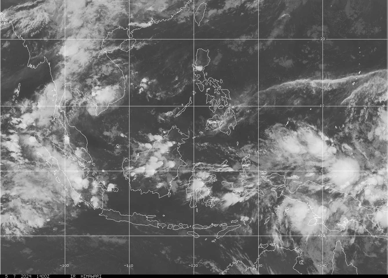
The center is definitely exposed right now, that's why I though the center was at the area with thick convection.
From NRL:
20110725.0701.mtsat2.x.ir1km_bw.10WTEN.30kts-1000mb-135N-1267E

Sat loop
http://www.goes.noaa.gov/sohemi/sohemiloops/vsmtsatw.html
From NRL:
20110725.0701.mtsat2.x.ir1km_bw.10WTEN.30kts-1000mb-135N-1267E
Sat loop
http://www.goes.noaa.gov/sohemi/sohemiloops/vsmtsatw.html
0 likes
Personal Forecast Disclaimer:
The posts in this forum are NOT official forecast and should not be used as such. They are just the opinion of the poster and may or may not be backed by sound meteorological data. They are NOT endorsed by any professional institution or storm2k.org. For official information, please refer to the NHC and NWS products.
The posts in this forum are NOT official forecast and should not be used as such. They are just the opinion of the poster and may or may not be backed by sound meteorological data. They are NOT endorsed by any professional institution or storm2k.org. For official information, please refer to the NHC and NWS products.
-
StormingB81

- S2K Supporter

- Posts: 5676
- Age: 44
- Joined: Thu Aug 27, 2009 1:45 am
- Location: Rockledge, Florida
-
dexterlabio
- Category 5
- Posts: 3505
- Joined: Sat Oct 24, 2009 11:50 pm
Re: WPAC: TEN - Tropical Depression
WTPN31 PGTW 250900
MSGID/GENADMIN/NAVMARFCSTCEN PEARL HARBOR HI/JTWC//
SUBJ/TROPICAL CYCLONE WARNING//
RMKS/
1. TROPICAL DEPRESSION 10W (TEN) WARNING NR 003
01 ACTIVE TROPICAL CYCLONE IN NORTHWESTPAC
MAX SUSTAINED WINDS BASED ON ONE-MINUTE AVERAGE
WIND RADII VALID OVER OPEN WATER ONLY
---
WARNING POSITION:
250600Z --- NEAR 13.5N 126.7E
MOVEMENT PAST SIX HOURS - 310 DEGREES AT 09 KTS
POSITION ACCURATE TO WITHIN 060 NM
POSITION BASED ON CENTER LOCATED BY SATELLITE
PRESENT WIND DISTRIBUTION:
MAX SUSTAINED WINDS - 030 KT, GUSTS 040 KT
WIND RADII VALID OVER OPEN WATER ONLY
REPEAT POSIT: 13.5N 126.7E
---
FORECASTS:
12 HRS, VALID AT:
251800Z --- 14.6N 125.6E
MAX SUSTAINED WINDS - 035 KT, GUSTS 045 KT
WIND RADII VALID OVER OPEN WATER ONLY
VECTOR TO 24 HR POSIT: 320 DEG/ 08 KTS
---
24 HRS, VALID AT:
260600Z --- 15.8N 124.5E
MAX SUSTAINED WINDS - 040 KT, GUSTS 050 KT
WIND RADII VALID OVER OPEN WATER ONLY
RADIUS OF 034 KT WINDS - 045 NM NORTHEAST QUADRANT
040 NM SOUTHEAST QUADRANT
035 NM SOUTHWEST QUADRANT
040 NM NORTHWEST QUADRANT
VECTOR TO 36 HR POSIT: 320 DEG/ 08 KTS
---
36 HRS, VALID AT:
261800Z --- 17.1N 123.4E
MAX SUSTAINED WINDS - 045 KT, GUSTS 055 KT
WIND RADII VALID OVER OPEN WATER ONLY
RADIUS OF 034 KT WINDS - 060 NM NORTHEAST QUADRANT
055 NM SOUTHEAST QUADRANT
050 NM SOUTHWEST QUADRANT
055 NM NORTHWEST QUADRANT
VECTOR TO 48 HR POSIT: 315 DEG/ 08 KTS
---
EXTENDED OUTLOOK:
48 HRS, VALID AT:
270600Z --- 18.2N 122.2E
MAX SUSTAINED WINDS - 050 KT, GUSTS 065 KT
WIND RADII VALID OVER OPEN WATER ONLY
RADIUS OF 034 KT WINDS - 070 NM NORTHEAST QUADRANT
065 NM SOUTHEAST QUADRANT
035 NM SOUTHWEST QUADRANT
070 NM NORTHWEST QUADRANT
VECTOR TO 72 HR POSIT: 305 DEG/ 08 KTS
---
72 HRS, VALID AT:
280600Z --- 20.0N 119.6E
MAX SUSTAINED WINDS - 055 KT, GUSTS 070 KT
WIND RADII VALID OVER OPEN WATER ONLY
RADIUS OF 050 KT WINDS - 015 NM NORTHEAST QUADRANT
015 NM SOUTHEAST QUADRANT
015 NM SOUTHWEST QUADRANT
015 NM NORTHWEST QUADRANT
RADIUS OF 034 KT WINDS - 080 NM NORTHEAST QUADRANT
075 NM SOUTHEAST QUADRANT
075 NM SOUTHWEST QUADRANT
080 NM NORTHWEST QUADRANT
VECTOR TO 96 HR POSIT: 305 DEG/ 09 KTS
---
LONG RANGE OUTLOOK:
NOTE...ERRORS FOR TRACK HAVE AVERAGED NEAR 250 NM
ON DAY 4 AND 350 NM ON DAY 5... AND FOR INTENSITY
NEAR 20 KT EACH DAY.
---
96 HRS, VALID AT:
290600Z --- 22.0N 116.4E
MAX SUSTAINED WINDS - 040 KT, GUSTS 050 KT
WIND RADII VALID OVER OPEN WATER ONLY
VECTOR TO 120 HR POSIT: 300 DEG/ 09 KTS
---
120 HRS, VALID AT:
300600Z --- 23.8N 112.8E
MAX SUSTAINED WINDS - 020 KT, GUSTS 030 KT
WIND RADII VALID OVER OPEN WATER ONLY
DISSIPATED AS A SIGNIFICANT TROPICAL CYCLONE OVER LAND
---
REMARKS:
250900Z POSITION NEAR 13.8N 126.4E.
TROPICAL DEPRESSION (TD) 10W (TEN), LOCATED APPROXIMATELY 335 NM
EAST OF MANILA, PHILIPPINES, HAS TRACKED NORTHWESTWARD AT 09 KNOTS
OVER THE PAST SIX HOURS. ANIMATED MULTISPECTRAL SATELLITE IMAGERY
(MSI) SHOWS THE LOW LEVEL CIRCULATION CENTER (LLCC) PARTIALLY
EXPOSED TO THE EAST OF THE CENTRAL CONVECTION. TIME LAPSE INFRARED
SATELLITE IMAGERY ANALYSIS REVEALS THE FORMATIVE BANDS FEEDING INTO
THE CYCLONE CONTINUE TO DEEPEN AND BECOME MORE ORGANIZED. THE
INITIAL POSITION IS BASED ON THE MSI ANIMATION WITH A FAIR DEGREE OF
CONFIDENCE. THE INITIAL INTENSITY IS DERIVED FROM A 240153Z ASCAT
PASS SHOWING 30 KNOT UNFLAGGED WINDS ALONG THE WEAK NORTHWEST
QUADRANT OF THE LLCC. UPPER LEVEL ANALYSIS INDICATES THE SYSTEM IS
IN THE VICINITY OF A RIDGE AXIS IN AN AREA OF LOW TO MODERATE
(10-20 KNOT) EASTERLY VERTICAL WIND SHEAR. ANIMATED WATER VAPOR
IMAGERY SHOWS AN EQUATORWARD OUTFLOW CHANNEL ON THE SOUTHWEST
PERIPHERY OF THE SYSTEM. TD 10W IS TRACKING ALONG THE SOUTHWEST
EXTENSION OF A DEEP-LAYERED SUBTROPICAL RIDGE ANCHORED EAST OF
JAPAN. IT IS EXPECTED TO SLOWLY INTENSIFY AS IT CONTINUES ALONG THIS
TRACK OVER THE NEXT 48 HOURS, AFTERWHICH, IT WILL PROCEED ON A
SLIGHTLY MORE WESTWARD DIRECTION AS THE STEERING RIDGE RECEDES,
EVENTUALLY MAKING LANDFALL NORTHEAST OF HONG KONG AFTER TAU 96. THE
AVAILABLE NUMERICAL GUIDANCE FANS OUT TO A 30-DEGREE SPREAD WITH
UKMET TO THE LEFT OF AND NOGAPS TO THE RIGHT OF THE ENVELOPE. THIS
TRACK FORECAST IS TO THE RIGHT OF CONSENSUS FAVORING A RECEDING STR.
NEXT WARNINGS AT 251500Z, 252100Z, 260300Z AND 260900Z.//
NNNN

Landfall still imminent at the NE portion of Luzon. Actually this is quite similar to Euro's 00z run.
JMA:
<Analyses at 25/06 UTC>
Scale -
Intensity -
TD
Center position N13°05'(13.1°)
E127°25'(127.4°)
Direction and speed of movement WNW 15km/h(8kt)
Central pressure 1002hPa
Maximum wind speed near the center 15m/s(30kt)
Maximum wind gust speed 23m/s(45kt)
<Forecast for 26/06 UTC>
Intensity -
Center position of probability circle N14°35'(14.6°)
E124°55'(124.9°)
Direction and speed of movement WNW 15km/h(7kt)
Central pressure 998hPa
Maximum wind speed near the center 18m/s(35kt)
Maximum wind gust speed 25m/s(50kt)
Radius of probability circle 220km(120NM)

MSGID/GENADMIN/NAVMARFCSTCEN PEARL HARBOR HI/JTWC//
SUBJ/TROPICAL CYCLONE WARNING//
RMKS/
1. TROPICAL DEPRESSION 10W (TEN) WARNING NR 003
01 ACTIVE TROPICAL CYCLONE IN NORTHWESTPAC
MAX SUSTAINED WINDS BASED ON ONE-MINUTE AVERAGE
WIND RADII VALID OVER OPEN WATER ONLY
---
WARNING POSITION:
250600Z --- NEAR 13.5N 126.7E
MOVEMENT PAST SIX HOURS - 310 DEGREES AT 09 KTS
POSITION ACCURATE TO WITHIN 060 NM
POSITION BASED ON CENTER LOCATED BY SATELLITE
PRESENT WIND DISTRIBUTION:
MAX SUSTAINED WINDS - 030 KT, GUSTS 040 KT
WIND RADII VALID OVER OPEN WATER ONLY
REPEAT POSIT: 13.5N 126.7E
---
FORECASTS:
12 HRS, VALID AT:
251800Z --- 14.6N 125.6E
MAX SUSTAINED WINDS - 035 KT, GUSTS 045 KT
WIND RADII VALID OVER OPEN WATER ONLY
VECTOR TO 24 HR POSIT: 320 DEG/ 08 KTS
---
24 HRS, VALID AT:
260600Z --- 15.8N 124.5E
MAX SUSTAINED WINDS - 040 KT, GUSTS 050 KT
WIND RADII VALID OVER OPEN WATER ONLY
RADIUS OF 034 KT WINDS - 045 NM NORTHEAST QUADRANT
040 NM SOUTHEAST QUADRANT
035 NM SOUTHWEST QUADRANT
040 NM NORTHWEST QUADRANT
VECTOR TO 36 HR POSIT: 320 DEG/ 08 KTS
---
36 HRS, VALID AT:
261800Z --- 17.1N 123.4E
MAX SUSTAINED WINDS - 045 KT, GUSTS 055 KT
WIND RADII VALID OVER OPEN WATER ONLY
RADIUS OF 034 KT WINDS - 060 NM NORTHEAST QUADRANT
055 NM SOUTHEAST QUADRANT
050 NM SOUTHWEST QUADRANT
055 NM NORTHWEST QUADRANT
VECTOR TO 48 HR POSIT: 315 DEG/ 08 KTS
---
EXTENDED OUTLOOK:
48 HRS, VALID AT:
270600Z --- 18.2N 122.2E
MAX SUSTAINED WINDS - 050 KT, GUSTS 065 KT
WIND RADII VALID OVER OPEN WATER ONLY
RADIUS OF 034 KT WINDS - 070 NM NORTHEAST QUADRANT
065 NM SOUTHEAST QUADRANT
035 NM SOUTHWEST QUADRANT
070 NM NORTHWEST QUADRANT
VECTOR TO 72 HR POSIT: 305 DEG/ 08 KTS
---
72 HRS, VALID AT:
280600Z --- 20.0N 119.6E
MAX SUSTAINED WINDS - 055 KT, GUSTS 070 KT
WIND RADII VALID OVER OPEN WATER ONLY
RADIUS OF 050 KT WINDS - 015 NM NORTHEAST QUADRANT
015 NM SOUTHEAST QUADRANT
015 NM SOUTHWEST QUADRANT
015 NM NORTHWEST QUADRANT
RADIUS OF 034 KT WINDS - 080 NM NORTHEAST QUADRANT
075 NM SOUTHEAST QUADRANT
075 NM SOUTHWEST QUADRANT
080 NM NORTHWEST QUADRANT
VECTOR TO 96 HR POSIT: 305 DEG/ 09 KTS
---
LONG RANGE OUTLOOK:
NOTE...ERRORS FOR TRACK HAVE AVERAGED NEAR 250 NM
ON DAY 4 AND 350 NM ON DAY 5... AND FOR INTENSITY
NEAR 20 KT EACH DAY.
---
96 HRS, VALID AT:
290600Z --- 22.0N 116.4E
MAX SUSTAINED WINDS - 040 KT, GUSTS 050 KT
WIND RADII VALID OVER OPEN WATER ONLY
VECTOR TO 120 HR POSIT: 300 DEG/ 09 KTS
---
120 HRS, VALID AT:
300600Z --- 23.8N 112.8E
MAX SUSTAINED WINDS - 020 KT, GUSTS 030 KT
WIND RADII VALID OVER OPEN WATER ONLY
DISSIPATED AS A SIGNIFICANT TROPICAL CYCLONE OVER LAND
---
REMARKS:
250900Z POSITION NEAR 13.8N 126.4E.
TROPICAL DEPRESSION (TD) 10W (TEN), LOCATED APPROXIMATELY 335 NM
EAST OF MANILA, PHILIPPINES, HAS TRACKED NORTHWESTWARD AT 09 KNOTS
OVER THE PAST SIX HOURS. ANIMATED MULTISPECTRAL SATELLITE IMAGERY
(MSI) SHOWS THE LOW LEVEL CIRCULATION CENTER (LLCC) PARTIALLY
EXPOSED TO THE EAST OF THE CENTRAL CONVECTION. TIME LAPSE INFRARED
SATELLITE IMAGERY ANALYSIS REVEALS THE FORMATIVE BANDS FEEDING INTO
THE CYCLONE CONTINUE TO DEEPEN AND BECOME MORE ORGANIZED. THE
INITIAL POSITION IS BASED ON THE MSI ANIMATION WITH A FAIR DEGREE OF
CONFIDENCE. THE INITIAL INTENSITY IS DERIVED FROM A 240153Z ASCAT
PASS SHOWING 30 KNOT UNFLAGGED WINDS ALONG THE WEAK NORTHWEST
QUADRANT OF THE LLCC. UPPER LEVEL ANALYSIS INDICATES THE SYSTEM IS
IN THE VICINITY OF A RIDGE AXIS IN AN AREA OF LOW TO MODERATE
(10-20 KNOT) EASTERLY VERTICAL WIND SHEAR. ANIMATED WATER VAPOR
IMAGERY SHOWS AN EQUATORWARD OUTFLOW CHANNEL ON THE SOUTHWEST
PERIPHERY OF THE SYSTEM. TD 10W IS TRACKING ALONG THE SOUTHWEST
EXTENSION OF A DEEP-LAYERED SUBTROPICAL RIDGE ANCHORED EAST OF
JAPAN. IT IS EXPECTED TO SLOWLY INTENSIFY AS IT CONTINUES ALONG THIS
TRACK OVER THE NEXT 48 HOURS, AFTERWHICH, IT WILL PROCEED ON A
SLIGHTLY MORE WESTWARD DIRECTION AS THE STEERING RIDGE RECEDES,
EVENTUALLY MAKING LANDFALL NORTHEAST OF HONG KONG AFTER TAU 96. THE
AVAILABLE NUMERICAL GUIDANCE FANS OUT TO A 30-DEGREE SPREAD WITH
UKMET TO THE LEFT OF AND NOGAPS TO THE RIGHT OF THE ENVELOPE. THIS
TRACK FORECAST IS TO THE RIGHT OF CONSENSUS FAVORING A RECEDING STR.
NEXT WARNINGS AT 251500Z, 252100Z, 260300Z AND 260900Z.//
NNNN
Landfall still imminent at the NE portion of Luzon. Actually this is quite similar to Euro's 00z run.
JMA:
<Analyses at 25/06 UTC>
Scale -
Intensity -
TD
Center position N13°05'(13.1°)
E127°25'(127.4°)
Direction and speed of movement WNW 15km/h(8kt)
Central pressure 1002hPa
Maximum wind speed near the center 15m/s(30kt)
Maximum wind gust speed 23m/s(45kt)
<Forecast for 26/06 UTC>
Intensity -
Center position of probability circle N14°35'(14.6°)
E124°55'(124.9°)
Direction and speed of movement WNW 15km/h(7kt)
Central pressure 998hPa
Maximum wind speed near the center 18m/s(35kt)
Maximum wind gust speed 25m/s(50kt)
Radius of probability circle 220km(120NM)
0 likes
Personal Forecast Disclaimer:
The posts in this forum are NOT official forecast and should not be used as such. They are just the opinion of the poster and may or may not be backed by sound meteorological data. They are NOT endorsed by any professional institution or storm2k.org. For official information, please refer to the NHC and NWS products.
The posts in this forum are NOT official forecast and should not be used as such. They are just the opinion of the poster and may or may not be backed by sound meteorological data. They are NOT endorsed by any professional institution or storm2k.org. For official information, please refer to the NHC and NWS products.
-
climateconcern23
- Tropical Low

- Posts: 35
- Age: 35
- Joined: Sat Mar 05, 2011 4:38 am
- Location: Philippines
- Contact:
-
Typhoon Hunter
- WesternPacificWeather.com

- Posts: 1222
- Joined: Wed Oct 11, 2006 11:37 am
- Location: Tokyo
- Contact:
Re: WPAC: TEN - Tropical Depression
JTWC still being pretty conservative with intensity compared to what recent model runs are showing. Indeed ECMWF going for quite a landfall on Guangdong later in the week:

Uploaded with ImageShack.us
The model spread is really quite big at the moment so all of Luzon really needs to be prepared for a soaking.

Uploaded with ImageShack.us
The model spread is really quite big at the moment so all of Luzon really needs to be prepared for a soaking.
0 likes
-
dexterlabio
- Category 5
- Posts: 3505
- Joined: Sat Oct 24, 2009 11:50 pm
Re: WPAC: TEN - Tropical Depression
Heavy precipitation over Bicol region.

0 likes
Personal Forecast Disclaimer:
The posts in this forum are NOT official forecast and should not be used as such. They are just the opinion of the poster and may or may not be backed by sound meteorological data. They are NOT endorsed by any professional institution or storm2k.org. For official information, please refer to the NHC and NWS products.
The posts in this forum are NOT official forecast and should not be used as such. They are just the opinion of the poster and may or may not be backed by sound meteorological data. They are NOT endorsed by any professional institution or storm2k.org. For official information, please refer to the NHC and NWS products.

Yeah ECM tucks this into a fairly decent looking system so its going to need rather close watching...
0 likes
Personal Forecast Disclaimer:
The posts in this forum are NOT official forecast and should not be used as such. They are just the opinion of the poster and may or may not be backed by sound meteorological data. They are NOT endorsed by any professional institution or storm2k.org. For official information, please refer to the NHC and NWS products
The posts in this forum are NOT official forecast and should not be used as such. They are just the opinion of the poster and may or may not be backed by sound meteorological data. They are NOT endorsed by any professional institution or storm2k.org. For official information, please refer to the NHC and NWS products
-
Typhoon Hunter
- WesternPacificWeather.com
- Posts: 1222
- Joined: Wed Oct 11, 2006 11:37 am
- Location: Tokyo
- Contact:
Sounds like a wet and wild evening in Bicol, just got this message from @bicolanodevil on Twitter, he lives near Mayon:
"@typhoonfury just got back home... heavy rains and strong winds. broken tree branches and small ones got uprooted already...."
"@typhoonfury just got back home... heavy rains and strong winds. broken tree branches and small ones got uprooted already...."
Last edited by Typhoon Hunter on Mon Jul 25, 2011 5:45 am, edited 1 time in total.
0 likes
Yeah looks like a good burst of convection over there at the moment.
Will be interesting to see exactly what track it takes and whether it can pull itself together in any meaningful fashion.
Will be interesting to see exactly what track it takes and whether it can pull itself together in any meaningful fashion.
0 likes
Personal Forecast Disclaimer:
The posts in this forum are NOT official forecast and should not be used as such. They are just the opinion of the poster and may or may not be backed by sound meteorological data. They are NOT endorsed by any professional institution or storm2k.org. For official information, please refer to the NHC and NWS products
The posts in this forum are NOT official forecast and should not be used as such. They are just the opinion of the poster and may or may not be backed by sound meteorological data. They are NOT endorsed by any professional institution or storm2k.org. For official information, please refer to the NHC and NWS products
-
alan1961

- Category 2
- Posts: 771
- Joined: Mon Mar 20, 2006 11:58 am
- Location: Derby, Derbyshire, England
- Contact:
Re: WPAC: TEN - Tropical Depression
GFS have this storm around Hainan Island at 144hrs..looks a decent one too...track i'm sure will have twists and turns as always though.


0 likes
So thats both the ECM and the GFS that develop a fairly healthy system, the ECM is much faster with regards to motion and further north-east but both are fairly strong. I think the JWTC may have to up thier intensity forecasts a little.
0 likes
Personal Forecast Disclaimer:
The posts in this forum are NOT official forecast and should not be used as such. They are just the opinion of the poster and may or may not be backed by sound meteorological data. They are NOT endorsed by any professional institution or storm2k.org. For official information, please refer to the NHC and NWS products
The posts in this forum are NOT official forecast and should not be used as such. They are just the opinion of the poster and may or may not be backed by sound meteorological data. They are NOT endorsed by any professional institution or storm2k.org. For official information, please refer to the NHC and NWS products
-
Typhoon Hunter
- WesternPacificWeather.com
- Posts: 1222
- Joined: Wed Oct 11, 2006 11:37 am
- Location: Tokyo
- Contact:
Re:
KWT wrote:So thats both the ECM and the GFS that develop a fairly healthy system, the ECM is much faster with regards to motion and further north-east but both are fairly strong. I think the JWTC may have to up thier intensity forecasts a little.
UKMET and CMC too. As I mentioned earlier JTWC are often hopelessly wrong with their intensity forecasts for storms entering SCS. Koppu, Molave and Conson perfect examples in last couple of years.
0 likes
How agressive are those two models TH?
No reason to think this won't become a TY, just depends on whether it ends up going so fast towards land that it runs out of time, its not going to weaken though like the JWTC think it will.
No reason to think this won't become a TY, just depends on whether it ends up going so fast towards land that it runs out of time, its not going to weaken though like the JWTC think it will.
0 likes
Personal Forecast Disclaimer:
The posts in this forum are NOT official forecast and should not be used as such. They are just the opinion of the poster and may or may not be backed by sound meteorological data. They are NOT endorsed by any professional institution or storm2k.org. For official information, please refer to the NHC and NWS products
The posts in this forum are NOT official forecast and should not be used as such. They are just the opinion of the poster and may or may not be backed by sound meteorological data. They are NOT endorsed by any professional institution or storm2k.org. For official information, please refer to the NHC and NWS products
-
Typhoon Hunter
- WesternPacificWeather.com
- Posts: 1222
- Joined: Wed Oct 11, 2006 11:37 am
- Location: Tokyo
- Contact:
Re:
KWT wrote:How agressive are those two models TH?
No reason to think this won't become a TY, just depends on whether it ends up going so fast towards land that it runs out of time, its not going to weaken though like the JWTC think it will.
UKMET 00z run had 77kts at 925hPa level - http://moe.met.fsu.edu/cyclonephase/ukm/fcst/archive/11072500/15.html
CMC 00z run peak at 80kts at 925hPa - http://moe.met.fsu.edu/cyclonephase/cmc/fcst/archive/11072500/26.html
NOGAPS a more conservative 53kts! - http://moe.met.fsu.edu/cyclonephase/ngp/fcst/archive/11072500/16.html
0 likes


Convectivly pretty active, looks like the convection has become a little more focused in recent hours.
0 likes
Personal Forecast Disclaimer:
The posts in this forum are NOT official forecast and should not be used as such. They are just the opinion of the poster and may or may not be backed by sound meteorological data. They are NOT endorsed by any professional institution or storm2k.org. For official information, please refer to the NHC and NWS products
The posts in this forum are NOT official forecast and should not be used as such. They are just the opinion of the poster and may or may not be backed by sound meteorological data. They are NOT endorsed by any professional institution or storm2k.org. For official information, please refer to the NHC and NWS products
Who is online
Users browsing this forum: No registered users and 13 guests