ATL: BRET - Remnants - Discussion
Moderator: S2k Moderators


Re: ATL: BRET - Tropical Storm - Discussion
Certainly a chance but it's too far out to tell. I am hoping the Euro verifies. We may see a significant shift west of the models tomorrow.[/quote]
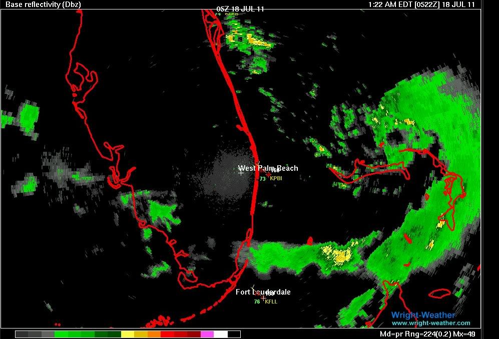
It shows Bret moving south of Florida into the Gulf. We'll have to wait and see. If Bret is still moving south in 12 hours the gulf coast may catch a surprise.[/quote]
Unless you are talking about an earlier run, the 0Z EURO is only out 24hrs and initialized at 1014MB which we know is not correct. Now the 12Z showed Cindy moving into the GOM at 240hrs....
0 likes
-
SouthDadeFish

- Professional-Met

- Posts: 2835
- Joined: Thu Sep 23, 2010 2:54 pm
- Location: Miami, FL
- Contact:
Re: ATL: BRET - Tropical Storm - Discussion
Ivanhater wrote:Well hot damn!
its got an eye!!! or an eyelike feature....
0 likes
-
MississippiWx

- S2K Supporter

- Posts: 1720
- Joined: Sat Aug 14, 2010 1:44 pm
- Location: Hattiesburg, Mississippi
Re: ATL: BRET - Tropical Storm - Discussion
With improving upper level conditions, Bret could push hurricane status. The waters underneath him are 30-32C, which is high-octane for any tropical system. Certainly an interesting drop in pressure tonight!
0 likes
This post is not an official forecast and should not be used as such. It is just the opinion of MississippiWx and may or may not be backed by sound meteorological data. It is not endorsed by any professional institution including storm2k.org. For Official Information please refer to the NHC and NWS products.
-
South Texas Storms

- Professional-Met
- Posts: 4257
- Joined: Thu Jun 24, 2010 12:28 am
- Location: Houston, TX
Re: ATL: BRET - Tropical Storm - Discussion
ROCK wrote:Certainly a chance but it's too far out to tell. I am hoping the Euro verifies. We may see a significant shift west of the models tomorrow.
It shows Bret moving south of Florida into the Gulf. We'll have to wait and see. If Bret is still moving south in 12 hours the gulf coast may catch a surprise.[/quote]
Unless you are talking about an earlier run, the 0Z EURO is only out 24hrs and initialized at 1014MB which we know is not correct. Now the 12Z showed Cindy moving into the GOM at 240hrs....[/quote]
Should we just throw out all of the models right now as they are initializing Bret to be much weaker than he really is?
0 likes
Re: ATL: BRET - Tropical Storm - Discussion
I wouldnt throw them out but I would like to see a decent run....
0 likes

000
URNT15 KNHC 180605
AF308 0202A BRET HDOB 22 20110718
055530 2708N 07654W 8494 01545 //// +164 //// 192041 041 029 001 05
055600 2710N 07654W 8491 01547 //// +161 //// 192041 041 029 002 01
055630 2712N 07654W 8492 01546 //// +157 //// 194043 043 028 004 01
055700 2714N 07654W 8494 01543 //// +153 //// 194042 043 029 003 01
055730 2716N 07654W 8494 01543 //// +154 //// 195043 043 030 004 05
055800 2718N 07654W 8494 01543 //// +150 //// 193042 043 033 005 01
055830 2720N 07654W 8494 01542 //// +145 //// 191040 041 038 007 05
055900 2721N 07654W 8493 01545 //// +139 //// 190041 042 038 008 01
055930 2723N 07654W 8491 01551 //// +143 //// 189043 044 038 009 01
060000 2725N 07654W 8488 01551 //// +140 //// 186043 044 040 010 05
060030 2727N 07654W 8485 01557 //// +131 //// 156039 041 051 027 05
060100 2729N 07653W 8494 01539 //// +128 //// 144039 041 049 036 01
060130 2731N 07653W 8500 01537 //// +126 //// 140043 047 051 025 01
060200 2733N 07653W 8479 01554 //// +134 //// 127046 048 049 025 05
060230 2735N 07653W 8489 01547 //// +129 //// 132039 043 045 026 01
060300 2737N 07653W 8480 01562 //// +129 //// 135038 038 033 012 05
060330 2738N 07653W 8499 01540 //// +141 //// 135037 038 032 011 05
060400 2740N 07653W 8492 01550 //// +149 //// 134034 035 025 006 05
060430 2742N 07653W 8492 01551 //// +150 //// 132033 034 026 005 01
060500 2744N 07653W 8493 01551 //// +149 //// 131032 032 025 007 01
$$
0 likes
-
Ivanhater

- Storm2k Moderator

- Posts: 11221
- Age: 39
- Joined: Fri Jul 01, 2005 8:25 am
- Location: Pensacola
Re: ATL: BRET - Tropical Storm - Discussion
You have this puppy trying to make a run at hurricane status and the global models still can't see it.....2011 is going to be a fun year...buckle up everyone!
0 likes
Michael
-
bamajammer4eva
- Category 4

- Posts: 907
- Joined: Sun Apr 18, 2010 3:21 am
- Location: Ozark, AL
Re: ATL: BRET - Tropical Storm - Discussion
If Bret strengthens deeper than forecast couldn't that make BAMD the correct model?

Uploaded with ImageShack.us

Uploaded with ImageShack.us
0 likes
Dropsonde Observations
--------------------------------------------------------------------------------
000
UZNT13 KNHC 180526
XXAA 68058 99271 70780 08078 99002 27624 22509 00021 27423 22510
92709 22208 23011 85447 20456 27010 88999 77999
31313 09608 80512
61616 AF308 0202A BRET OB 05
62626 EYE SPL 2714N07797W 0514 MBL WND 23510 AEV 20802 DLM WND 23
508 002849 WL150 23010 083 REL 2714N07797W 051229 SPG 2714N07797W
051417 =
XXBB 68058 99271 70780 08078 00002 27624 11927 22207 22904 23447
33850 20456 44849 20256
21212 00002 22509 11917 23511 22885 23504 33862 26004 44849 27011
31313 09608 80512
61616 AF308 0202A BRET OB 05
62626 EYE SPL 2714N07797W 0514 MBL WND 23510 AEV 20802 DLM WND 23
508 002849 WL150 23010 083 REL 2714N07797W 051229 SPG 2714N07797W
051417 =
;
0 likes
-
MississippiWx
- S2K Supporter
- Posts: 1720
- Joined: Sat Aug 14, 2010 1:44 pm
- Location: Hattiesburg, Mississippi
Re: ATL: BRET - Tropical Storm - Discussion
bamajammer4eva wrote:If Bret strengthens deeper than forecast couldn't that make BAMD the correct model?
Uploaded with ImageShack.us
The BAM models are normally used for weaker systems.
0 likes
This post is not an official forecast and should not be used as such. It is just the opinion of MississippiWx and may or may not be backed by sound meteorological data. It is not endorsed by any professional institution including storm2k.org. For Official Information please refer to the NHC and NWS products.
-
South Texas Storms
- Professional-Met
- Posts: 4257
- Joined: Thu Jun 24, 2010 12:28 am
- Location: Houston, TX
Re: ATL: BRET - Tropical Storm - Discussion
Well what model should we trust right now? I wouldn't trust any.
0 likes

00z euro shows Bret to stay put in the area through tomorrow night.
By Tuesday night it shows the low level center to be east of Jacksonville start weakening while the mid level vorticity stays behind.
By Wednesday night it shows that it continues to weaken as it nears strong 30-40 knt NE shear east of the Carolinas.
By Tuesday night it shows the low level center to be east of Jacksonville start weakening while the mid level vorticity stays behind.
By Wednesday night it shows that it continues to weaken as it nears strong 30-40 knt NE shear east of the Carolinas.
0 likes
-
SouthDadeFish
- Professional-Met
- Posts: 2835
- Joined: Thu Sep 23, 2010 2:54 pm
- Location: Miami, FL
- Contact:
Atlantic USAF High-Density Observations
--------------------------------------------------------------------------------
000
URNT15 KNHC 180615
AF308 0202A BRET HDOB 23 20110718
060530 2745N 07653W 8492 01551 //// +152 //// 132032 032 028 008 01
060600 2747N 07653W 8492 01551 //// +153 //// 133032 032 029 009 01
060630 2749N 07653W 8493 01550 //// +151 //// 135032 032 029 009 01
060700 2751N 07653W 8494 01550 //// +149 //// 137032 033 029 009 05
060730 2753N 07653W 8494 01551 //// +142 //// 134030 031 030 011 05
060800 2754N 07653W 8490 01553 //// +141 //// 131031 031 030 013 01
060830 2756N 07653W 8497 01548 //// +141 //// 125030 031 031 010 05
060900 2758N 07653W 8492 01552 //// +134 //// 114026 028 041 025 05
060930 2800N 07653W 8502 01542 //// +124 //// 111027 028 042 020 01
061000 2801N 07653W 8489 01552 //// +140 //// 112025 026 033 012 01
061030 2803N 07653W 8492 01547 //// +149 //// 116025 025 028 008 01
061100 2805N 07653W 8494 01542 //// +150 //// 117024 025 /// /// 05
061130 2805N 07655W 8494 01543 //// +150 //// 114023 024 /// /// 05
061200 2804N 07656W 8499 01537 //// +149 //// 116021 021 028 004 01
061230 2802N 07658W 8492 01545 //// +147 //// 114022 023 028 005 01
061300 2801N 07659W 8490 01546 //// +147 //// 114024 025 029 007 05
061330 2800N 07700W 8490 01547 //// +140 //// 104023 023 032 011 01
061400 2759N 07702W 8494 01542 //// +136 //// 112023 025 036 017 05
061430 2758N 07703W 8485 01544 //// +131 //// 104027 030 045 022 05
061500 2756N 07704W 8514 01518 //// +136 //// 110027 027 041 019 05
$$
;
0 likes
-
MississippiWx
- S2K Supporter
- Posts: 1720
- Joined: Sat Aug 14, 2010 1:44 pm
- Location: Hattiesburg, Mississippi
I think I was totally wrong about the BAM being used for weaker systems, so scratch what I said above. LOL.
0 likes
This post is not an official forecast and should not be used as such. It is just the opinion of MississippiWx and may or may not be backed by sound meteorological data. It is not endorsed by any professional institution including storm2k.org. For Official Information please refer to the NHC and NWS products.
Who is online
Users browsing this forum: No registered users and 18 guests