
ATL: IRENE - Remnants - Discussion
Moderator: S2k Moderators
-
Dave

- Retired Staff

- Posts: 13442
- Age: 75
- Joined: Tue Aug 01, 2006 3:57 pm
- Location: Milan Indiana
- Contact:
NOAA2
0 likes
This post is NOT AN OFFICIAL FORECAST and should not be used as such. It is just the opinion of the poster and may or may not be backed by sound meteorological data. It is NOT endorsed by any professional institution including storm2k.org. For Official Information please refer to the NHC and NWS products.
-
Ivanhater

- Storm2k Moderator

- Posts: 11221
- Age: 39
- Joined: Fri Jul 01, 2005 8:25 am
- Location: Pensacola
Re: ATL: IRENE - Hurricane - Discussion
She continues to build up massive amounts of water as she gets stronger and bigger which is looking more and more likely to be pumped into areas of D.C and NYC with the latest track. Very bad news
0 likes
Michael

Its becoming very large now at least in terms of cloud coverage, its pretty amazing it has to be said!
Looks to me like it has sped up its forward motion a little more as well in the last couple of hours.
Looks to me like it has sped up its forward motion a little more as well in the last couple of hours.
0 likes
Personal Forecast Disclaimer:
The posts in this forum are NOT official forecast and should not be used as such. They are just the opinion of the poster and may or may not be backed by sound meteorological data. They are NOT endorsed by any professional institution or storm2k.org. For official information, please refer to the NHC and NWS products
The posts in this forum are NOT official forecast and should not be used as such. They are just the opinion of the poster and may or may not be backed by sound meteorological data. They are NOT endorsed by any professional institution or storm2k.org. For official information, please refer to the NHC and NWS products
-
Dave
- Retired Staff
- Posts: 13442
- Age: 75
- Joined: Tue Aug 01, 2006 3:57 pm
- Location: Milan Indiana
- Contact:
000
URNT15 KWBC 252248
NOAA2 2309A IRENE HDOB 18 20110825
223900 2625N 07715W 7537 02322 9834 +150 //// 255076 076 /// /// 05
223930 2623N 07715W 7537 02327 9841 +148 //// 256076 076 /// /// 05
224000 2621N 07715W 7538 02333 9849 +148 //// 258075 076 /// /// 05
224030 2619N 07715W 7536 02343 9857 +151 +146 258077 078 /// /// 03
224100 2618N 07715W 7536 02349 9865 +149 +144 257073 075 /// /// 03
224130 2616N 07715W 7537 02354 9873 +146 +146 257072 072 /// /// 03
224200 2614N 07715W 7536 02360 9880 +144 +149 258072 072 /// /// 03
224230 2612N 07715W 7536 02363 9888 +141 +144 257070 071 /// /// 03
224300 2610N 07716W 7538 02366 9895 +138 //// 258067 068 /// /// 05
224330 2608N 07716W 7537 02369 9902 +137 +140 259067 068 /// /// 03
224400 2607N 07716W 7537 02375 9901 +143 +135 258066 067 /// /// 03
224430 2605N 07716W 7537 02379 9910 +137 +137 259065 066 /// /// 03
224500 2603N 07716W 7536 02383 9905 +148 +128 259067 067 /// /// 03
224530 2601N 07716W 7537 02388 9912 +147 +131 260067 068 /// /// 03
224600 2559N 07716W 7535 02394 9920 +142 //// 259064 065 /// /// 05
224630 2557N 07716W 7535 02398 9924 +142 +147 260062 062 /// /// 03
224700 2555N 07716W 7536 02401 9928 +143 +147 261064 066 /// /// 03
224730 2553N 07716W 7538 02402 9931 +143 +148 262064 065 /// /// 03
224800 2551N 07716W 7538 02406 9938 +139 +144 267059 060 /// /// 03
224830 2549N 07716W 7539 02406 9938 +142 +146 268062 063 /// /// 03
0 likes
This post is NOT AN OFFICIAL FORECAST and should not be used as such. It is just the opinion of the poster and may or may not be backed by sound meteorological data. It is NOT endorsed by any professional institution including storm2k.org. For Official Information please refer to the NHC and NWS products.
-
maryellen40
- Tropical Low

- Posts: 20
- Joined: Sun Aug 21, 2011 2:21 pm
- Location: Michigan
Re: ATL: IRENE - Hurricane - Discussion
Ivanhater wrote:She continues to build up massive amounts of water as she gets stronger and bigger which is looking more and more likely to be pumped into areas of D.C and NYC with the latest track. Very bad news
and NYC officals are waiting until Saturday morning to determine if they are going to madatory evac low lying areas of the city.
0 likes
-
Dave
- Retired Staff
- Posts: 13442
- Age: 75
- Joined: Tue Aug 01, 2006 3:57 pm
- Location: Milan Indiana
- Contact:
Re: ATL: IRENE - Recon Discussion
tolakram wrote:Woops, stepping away for 30 minutes, then I'll be glad to take over for a while.
That'll work...just hit me on the main thread...I'll see it faster there.
0 likes


Wicked image TB, that shows very nicely the large size of Emily at the moment, its pretty impressive in size!
0 likes
Personal Forecast Disclaimer:
The posts in this forum are NOT official forecast and should not be used as such. They are just the opinion of the poster and may or may not be backed by sound meteorological data. They are NOT endorsed by any professional institution or storm2k.org. For official information, please refer to the NHC and NWS products
The posts in this forum are NOT official forecast and should not be used as such. They are just the opinion of the poster and may or may not be backed by sound meteorological data. They are NOT endorsed by any professional institution or storm2k.org. For official information, please refer to the NHC and NWS products

The size of Irene is amazing. She would fill most of the GOM. I hope everyone is heeding the evacs and getting off the Outer Banks now. It will look like Bolivar after IKE.
0 likes
The following post is NOT an official forecast and should not be used as such. It is just the opinion of the poster and may or may not be backed by sound meteorological data. It is NOT endorsed by any professional institution including storm2k.org For Official Information please refer to the NHC and NWS products.
-
SNOW_JOKE
- Tropical Depression

- Posts: 98
- Age: 42
- Joined: Mon Aug 01, 2011 7:47 pm
- Location: United Kingdom
Re: ATL: IRENE - Hurricane - Discussion
Updates Mayor Bloomberg orders evacs of zone in NYC with 270,000 residents effected so far in Broad Channel, Midland Beach, and Battery Park City , Coney Island, Manhatten Beach. Hospitals in low lying areas evacuating patients... LIRR will shut down.
Transit Authority says Mass Transit cannot run in sustained winds OVER 39mph.
Transit Authority says Mass Transit cannot run in sustained winds OVER 39mph.
0 likes
For Official Information please refer to the NHC and NWS Websites.
-
littlevince

- S2K Supporter

- Posts: 768
- Joined: Fri Oct 21, 2005 10:45 am
- Location: Portugal
Re: ATL: IRENE - Recon
000
URNT15 KNHC 252305
AF306 2109A IRENE HDOB 46 20110825
225530 2705N 07646W 6965 02892 9748 +105 +042 211084 085 067 006 00
225600 2706N 07647W 6972 02881 9725 +122 +043 208081 083 066 008 00
225630 2708N 07648W 6966 02880 9710 +127 +043 208081 082 064 001 00
225700 2709N 07650W 6970 02869 9701 +127 +044 209083 083 065 001 00
225730 2710N 07651W 6965 02863 9696 +123 +045 208084 086 064 003 03
225800 2712N 07653W 6970 02852 9693 +117 +046 207084 085 066 001 00
225830 2713N 07654W 6962 02847 9672 +124 +047 206084 085 066 005 00
225900 2714N 07656W 6963 02833 9669 +112 +047 202081 082 069 011 00
225930 2716N 07657W 6966 02818 9642 +126 +047 201080 081 070 011 00
230000 2717N 07659W 6969 02799 9636 +119 +047 201081 083 071 019 00
230030 2718N 07700W 6973 02785 9629 +112 +048 200078 081 071 020 00
230100 2720N 07702W 6967 02777 9596 +129 +049 199076 077 076 008 00
230130 2721N 07703W 6966 02763 9574 +136 +048 197078 078 073 007 00
230200 2723N 07705W 6968 02746 9555 +137 +049 194076 077 073 007 00
230230 2724N 07707W 6963 02732 9548 +126 +050 189070 072 071 006 00
230300 2725N 07708W 6954 02729 9533 +126 +051 191055 062 069 015 03
230330 2726N 07710W 6978 02691 9505 +143 +051 186051 052 047 003 03
230400 2727N 07712W 6965 02697 9484 +155 +051 185040 043 041 001 00
230430 2727N 07714W 6968 02685 9472 +158 +052 188030 031 036 001 00
230500 2727N 07716W 6966 02680 9464 +158 +055 189022 025 033 000 00
$$
;
0 likes
-
TheEuropean

- Professional-Met

- Posts: 1797
- Age: 60
- Joined: Tue Sep 20, 2005 3:17 pm
- Location: Voerde, Germany
- Contact:
Re: ATL: IRENE - Hurricane - Discussion
TheBurn wrote:22:55Z VIS/IR...
Hi, what's the source of this image?
0 likes
-
Hurricaneman

- Category 5

- Posts: 7404
- Age: 45
- Joined: Tue Aug 31, 2004 3:24 pm
- Location: central florida
Re: ATL: IRENE - Hurricane - Discussion
This is one of the top 5 largest hurricanes I have ever in the atlantic basin, its absolutly massive
0 likes
-
SunnyThoughts
- Category 5
- Posts: 2263
- Joined: Wed Jul 09, 2003 12:42 pm
- Location: Pensacola, Florida
Re: ATL: IRENE - Hurricane - Discussion
Trishasmom wrote:You really should not drink water that comes out of the water heater, as it may contain sediment and possibly bacteria. That's one reason you never use water from the hot water tap for cooking. The best solution is something like "mywatersafe". They make plastic containers from 5gal to 65gal. The 65 gallon plastic bag fits in your bathtub and has a pump attached. http://www.mywatersafe.com
I wouldn't drink water from the heater but it could be used to flush the toilets. I'm afraid we aren't in a position to buy anything at this point so we have to use what we can.
Trish, just clean your bathtub really good with whatever you have to clean it with. Rinse it really good. Fill it up with water. You can use it to dip out what you need to wash clothes..flush toilets..etc. Also, if you have some empty gallon plastic milk containers and 2 ltr empty soda bottles..fill those up also and put them in your freezer.. They will keep what food you have in there colder for longer, and you can use it as drinking water as it starts to melt. WE had to make due with what we had when I was young and going through canes in the south...I know exactly how you feel.
0 likes
-
Dave
- Retired Staff
- Posts: 13442
- Age: 75
- Joined: Tue Aug 01, 2006 3:57 pm
- Location: Milan Indiana
- Contact:
NOAA2

0 likes
This post is NOT AN OFFICIAL FORECAST and should not be used as such. It is just the opinion of the poster and may or may not be backed by sound meteorological data. It is NOT endorsed by any professional institution including storm2k.org. For Official Information please refer to the NHC and NWS products.
Re:
KatDaddy wrote:The size of Irene is amazing. She would fill most of the GOM. I hope everyone is heeding the evacs and getting off the Outer Banks now. It will look like Bolivar after IKE.
It is huge, may yet get a touch bigger as it starts to interact with the upper trough and the northern side expands yet further. We've already seen this in play over the last 4hrs.
0 likes
Personal Forecast Disclaimer:
The posts in this forum are NOT official forecast and should not be used as such. They are just the opinion of the poster and may or may not be backed by sound meteorological data. They are NOT endorsed by any professional institution or storm2k.org. For official information, please refer to the NHC and NWS products
The posts in this forum are NOT official forecast and should not be used as such. They are just the opinion of the poster and may or may not be backed by sound meteorological data. They are NOT endorsed by any professional institution or storm2k.org. For official information, please refer to the NHC and NWS products
-
SNOW_JOKE
- Tropical Depression
- Posts: 98
- Age: 42
- Joined: Mon Aug 01, 2011 7:47 pm
- Location: United Kingdom
Re: ATL: IRENE - Hurricane - Discussion
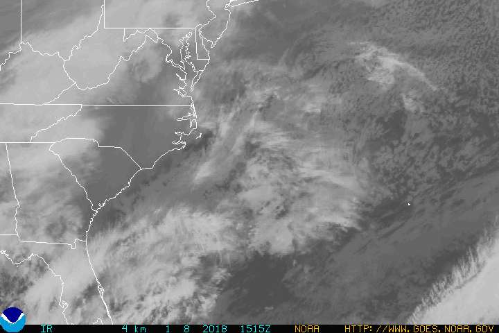
Irene on IR is already touching the Carolinas. http://www.goes.noaa.gov/GIFS/ECSTIR.JPG
0 likes
For Official Information please refer to the NHC and NWS Websites.
946.4mbs with some wind present according to the AF flight, looks like the center is just a touch to the north and the central pressure is probably a little lower then that.
0 likes
Personal Forecast Disclaimer:
The posts in this forum are NOT official forecast and should not be used as such. They are just the opinion of the poster and may or may not be backed by sound meteorological data. They are NOT endorsed by any professional institution or storm2k.org. For official information, please refer to the NHC and NWS products
The posts in this forum are NOT official forecast and should not be used as such. They are just the opinion of the poster and may or may not be backed by sound meteorological data. They are NOT endorsed by any professional institution or storm2k.org. For official information, please refer to the NHC and NWS products
-
Lowpressure

- S2K Supporter
- Posts: 2032
- Age: 59
- Joined: Sun Sep 14, 2003 9:17 am
- Location: Charlotte, North Carolina
Re:
KWT wrote:946.4mbs with some wind present according to the AF flight, looks like the center is just a touch to the north and the central pressure is probably a little lower then that.
Guessing next set is 945
0 likes
Who is online
Users browsing this forum: No registered users and 5 guests